
Ukinrek Maars
Encyclopedia
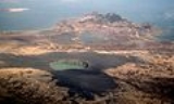
From Miller and others: "Ukinrek Maars are a pair of
phreatomagmatic explosion vents that formed on a low (less than 100 m high), 4-km-long, ridge in the Bering Sea
Lowland
1.5 km south of Becharof Lake
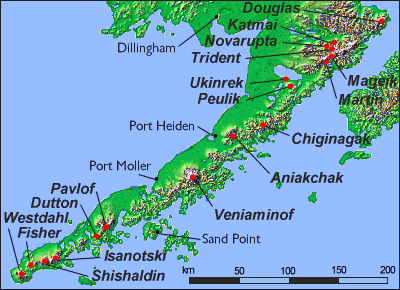
and 12 km northwest of Peulik Volcano
. West Maar, elliptical in shape and up to 170 m in diameter and 35 m deep,
formed on the northwest end of the ridge (Kienle and others, 1980). East Maar lies 600 m east of West Maar at a lower elevation. It is circular, up to 300 m in diameter and 70 m deep, and has a 49-m-high central lava dome that is now partly covered by a crater lake. Location of the maars apparently coincides with, and may be controlled by, the intersection of the Bruin Bay fault and regional structures (Kienle and others, 1980; Detterman and others, 1983)."
phreatomagmatic explosion vents that formed on a low (less than 100 m high), 4-km-long, ridge in the Bering Sea
Bering Sea
The Bering Sea is a marginal sea of the Pacific Ocean. It comprises a deep water basin, which then rises through a narrow slope into the shallower water above the continental shelves....
Lowland
Lowland
In physical geography, a lowland is any broad expanse of land with a general low level. The term is thus applied to the landward portion of the upward slope from oceanic depths to continental highlands, to a region of depression in the interior of a mountainous region, to a plain of denudation, or...
1.5 km south of Becharof Lake
Becharof Lake
Becharof Lake is a long lake on the Alaska Peninsula. It is located south-east of Egegik, in the Aleutian Range.-History:The lake was named in 1868 by naturalist W. H...
and 12 km northwest of Peulik Volcano
Ugashik-Peulik
Ugashik-Peulik is a stratovolcano in the U.S. state of Alaska. It is located to the south of Becharof Lake in Lake and Peninsula Borough on the Alaska Peninsula. It is part of the Aleutian Range. Its last eruption was in 1814.-Sources:* *...
. West Maar, elliptical in shape and up to 170 m in diameter and 35 m deep,
formed on the northwest end of the ridge (Kienle and others, 1980). East Maar lies 600 m east of West Maar at a lower elevation. It is circular, up to 300 m in diameter and 70 m deep, and has a 49-m-high central lava dome that is now partly covered by a crater lake. Location of the maars apparently coincides with, and may be controlled by, the intersection of the Bruin Bay fault and regional structures (Kienle and others, 1980; Detterman and others, 1983)."
Sources
- Volcanoes of the Alaska Peninsula and Aleutian Islands-Selected Photographs
- Miller, T. P., McGimsey, R. G., Richter, D. H., Riehle, J. R., Nye, C. J., Yount, M. E., and Dumoulin, J. A., 1998, Catalog of the historically active volcanoes of Alaska: U.S. Geological Survey Open-File Report OF 98-0582, 104 p. http://www.avo.alaska.edu/downloads/catalog.php
- Kienle, Juergen, Kyle, P. R., Self, Stephen, Motyka, R. J., and Lorenz, Volker, 1980, Ukinrek Maars, Alaska: I, April 1977 eruption sequence, petrology and tectonic setting: Journal of Volcanology and Geothermal Research, v. 7, n. 1, p. 11-37.
- Detterman, R. L., Case, J. E., Wilson, F. H., Yount, M. E., and Allaway, W. H. Jr., 1983, Generalized geologic map of the Ugashik, Bristol Bay, and part of the Karluk quadrangles, Alaska: U.S. Geological Survey Miscellaneous Field Studies Map MF 1539-A, unpaged, 1 sheet, scale 1:250,000.
- Alaska Volcano Observatory