
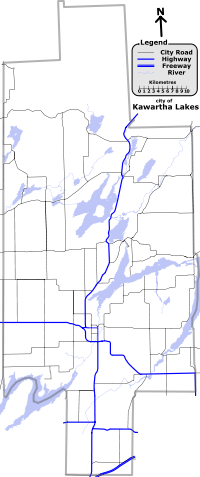
List of numbered roads in Kawartha Lakes, Ontario
Encyclopedia
Ontario
Ontario is a province of Canada, located in east-central Canada. It is Canada's most populous province and second largest in total area. It is home to the nation's most populous city, Toronto, and the nation's capital, Ottawa....
.The total length only counts concurrent
Concurrency (road)
A concurrency, overlap, or coincidence in a road network is an instance of one physical road bearing two or more different highway, motorway, or other route numbers...
roadways once. These roads include King's Highways that are signed and maintained by the province, as well as the Kawartha Lakes Roads under the jurisdiction of the city. The third type of existing roadway in the single-tier municipality of Kawartha Lakes
Kawartha Lakes
The city of Kawartha Lakes is a unitary municipality in Central Ontario, Canada. Although called a city, Kawartha Lakes is the size of a typical Ontarian county and is mostly rural....
is locally-maintained roads also called concession roads and sidelines, which are beyond the scope of this article. A fourth category of roads, secondary highways, have not existed within the region since 1998.
The 49 numbered highways provide year-round access to the mostly rural municipality. The longest of these roads is Highway 35
Highway 35 (Ontario)
King's Highway 35, also known as Highway 35, is a provincial highway in the Canadian province of Ontario, linking Highway 401 with Peterborough, Kawartha Lakes, and Algonquin Park. The highway travels from west of Newcastle, through Lindsay and the Kawarthas and into Haliburton before terminating...
, which stretches 86.7 kilometres (53.9 mi) across the municipality from the south to the north. The shortest numbered road is Kawartha Lakes Road 3, Hartley Road, a causeway
Causeway
In modern usage, a causeway is a road or railway elevated, usually across a broad body of water or wetland.- Etymology :When first used, the word appeared in a form such as “causey way” making clear its derivation from the earlier form “causey”. This word seems to have come from the same source by...
just less than a kilometre long crossing Mitchell Lake
Mitchell Lake (Ontario)
Mitchell Lake is a small, man-made lake in south-central Ontario, located in the former Eldon Township, of Victoria county...
.
Before 1998, several additional King's Highways and secondary highways were located in what was then known as Victoria County. These were transferred to the county in 1998. All county roads, including the former provincial highways, were renamed when Victoria County was abolished in 2001 and replaced with the City of Kawartha Lakes.
Types of roads
King's Highways
There are 168 kilometres (104.4 mi) of provincially maintained highways,There are 2.2 km (1.4 mi) of concurrent King's Highway, comprising Highway 35 and Highway 7A for 1.5 km (0.93205910497471 mi) and Highway 35 and Highway 7B for 0.7 km (0.434960915654865 mi). This means that the total of all the King's Highways is 170.2 kilometres (105.8 mi). termed "provincial highways" or "King's Highways" (a term adopted in 1930).Like the rest of Ontario, the provincially maintained highways in Kawartha Lakes are designated with a shield-shaped sign topped with a crown. The highway number is in the centre, with the word ONTARIO below. These signs are known as shields
Highway shield
A highway shield is a sign denoting the route number of a highway, usually in the form of a symbolic shape with the route number enclosed. As the focus of the sign, the route number is usually the sign's largest element, with other items on the sign rendered in smaller sizes or contrasting colours...
, but may be referred to as reassurance marker
Reassurance marker
A reassurance marker or road identification sign is a road sign that repeats the name or number of the current route. Typically posted at intervals alongside a numbered highway, the signs are intended to reassure drivers that they are traveling on the desired road .- North America :In the United...
s. Highway 7
Highway 7 (Ontario)
King's Highway 7, commonly referred to as Highway 7 and historically as the Northern Highway, is a provincially maintained highway in the Canadian province of Ontario...
, which is part of the Trans-Canada Highway
Trans-Canada Highway
The Trans-Canada Highway is a federal-provincial highway system that joins the ten provinces of Canada. It is, along with the Trans-Siberian Highway and Australia's Highway 1, one of the world's longest national highways, with the main route spanning 8,030 km...
, is also marked with a green maple leaf shield. Highways 7 and 35 together measure 140 km (87 mi) and account for 82.3% of the length of highways. The remaining 30.2 km (18.8 mi) comprises Highway 115, a controlled-access freeway in the southern corner of the city; Highway 7A, an alternate route to Highway 7 around the Lindsay area; and Highway 7B, a business route through Lindsay.
Provincially maintained highways generally have greater construction standards than municipally or locally maintained roads.
Although they are usually one lane in either direction, several short sections with two lanes in one direction as a passing lane
Passing lane
A passing lane or overtaking lane is the lane on a multi-lane highway or motorway closest to the center of the road ....
exist along the highways. The municipality's lone freeway, Highway 115
Highway 115 (Ontario)
King's Highway 115, commonly referred to as Highway 115 is a provincially maintained highway in the Canadian province of Ontario that connects Peterborough with Toronto via Highway 401...
, is two lanes in either direction for its entire length. There are three off ramps with Highway 115 in the region: One with at the southern boundary with Durham Region; one with ; and one with at the eastern boundary with Peterborough County.
City roads
There are 44 numbered city roads in Kawartha Lakes. Kawartha Lakes city roads are signed with a flowerpot-shaped sign, as are most regional and county roads in Ontario. The road number appears in the centre of the sign, with the word KAWARTHA above and the word LAKES below. Like King's Highways, these signs are known as shields.The total length of city roads is 739.3 kilometres (459.4 mi).There are 4 km (2.5 mi) of concurrent roadway. Routes 6 and 9 share 0.5 km (0.310686368324903 mi), 8 and 121 share 1.9 km (1.2 mi), 9 and 46 share 0.3 km (0.186411820994942 mi), 10 and 14 share 1.1 km (0.683510010314787 mi), and 45 and 121 share 0.2 km (0.124274547329961 mi). This means that the total of all the route lengths is 743.3 kilometres (461.9 mi).
History

Alongside this change, all Victoria County Roads received Kawartha Lakes Road designations, with unchanged numbers, and many new routes were established.
Prior to 1998, Victoria County contained twelve King's Highways. As part of a province-wide transfer of highways to municipal governments, known as downloading, seven were given new Victoria County designations following the prior provincial designations. The exceptions are Highway 35A which was renumbered to fill a gap in the route of Victoria County Road 8, and Highway 36B which was given the new designation of Victoria County Road 17.
The downloaded highways comprises Highway 35A, which was designated Victoria County Road 8; Highway 35B, incorporated into Highway 7B and Victoria County Road 15; Highway 36, designated as Victoria County Road 36; Highway 36B, designated as Victoria County Road 17; Highway 46, designated as Victoria County Road 46; Highway 48, designated as Victoria County Road 48; and Highway 121, designated as Victoria County Road 121.
Highway 7B was also shortened by several kilometres, and now only consists of the portion along Kent Street in Lindsay.
Secondary Highways
Three secondary highways, which existed in Victoria County prior to 1998, were also downloaded from the province to the county, and given new designations in addition to the downloading of King's Highways:- Highway 503, which ran from KirkfieldKirkfield, OntarioKirkfield is a village located in the city of Kawartha Lakes, in the Canadian province of Ontario. The unincorporated village was named in 1864 after the initial name, Novar, was rejected by the government. A list of 8 possible choices was then offered. The village, being predominantly Scottish at...
to KinmountKinmount, OntarioKinmount is a village with a population of approximately 500, located on the Burnt River in Ontario, Canada. The village is now part of the City of Kawartha Lakes. The village's hinterland covers large sections of both Haliburton and Peterborough counties for which it is a shopping and cultural...
, was renumbered as an extension of Victoria County Road 6 (Kirkfield to Sebright) and Victoria County Road 45 (Sebright to Kinmount). - Highway 505, which ran from near Victoria Road to in Uphill, was renumbered as an extension of Victoria County Road 35.
- Highway 649, which ran from BobcaygeonBobcaygeon, OntarioBobcaygeon is a community on the Trent-Severn Waterway in the City of Kawartha Lakes, east-central Ontario, Canada.Bobcaygeon was incorporated as village in 1876, and became known as the "Hub of the Kawarthas"...
north to Highway 121, was renumbered as Victoria County Road 49.
King's Highways
The following is a list of provincially-maintained highways in Kawartha Lakes. Communities are ordered by where the route encounters them (either from south to north or from west to east).| Route | Length | Western/Southern Terminus | Eastern/Northern Terminus | Communities | Comments | |
|---|---|---|---|---|---|---|
7 Highway 7 Ontario Highway 7 King's Highway 7, commonly referred to as Highway 7 and historically as the Northern Highway, is a provincially maintained highway in the Canadian province of Ontario... |
|
Kawartha Lakes Road 2 | Hayes Line | Manilla, Oakwood, Lindsay, Reaboro, Omemee | Part of the Trans-Canada Highway Trans-Canada Highway The Trans-Canada Highway is a federal-provincial highway system that joins the ten provinces of Canada. It is, along with the Trans-Siberian Highway and Australia's Highway 1, one of the world's longest national highways, with the main route spanning 8,030 km... |
|
| 8 | |
Kawartha Lakes–Durham Region Boundary | Dranoel Road | Bethany | ||
| 9 | |
Highway 7 | Kawartha Lakes Road 15 | Lindsay | Highway 7B and Highway 35B followed the same course, prior to the former being shortened to its current length, and the latter downloaded, in 1998; also known as Kent Street West | |
| 35 | |
Boundary Road | Laxton–Lutterworth Boundary Road | Lindsay, Cameron, Rosedale, Coboconk, Norland | ||
| 115 | |
Boundary Road | Glamorgan Road | Only freeway in the region | ||
| Note: All King's Highways, with the exception of 7B, continue in both directions into neighbouring counties and regions. | ||||||
City roads
The following is a list of the numbered city roads maintained by the City of Kawartha Lakes. Communities are ordered by where the route encounters them (either from south to north or from west to east).| Route | Name(s) | Length | Western/Southern Terminus | Eastern/Northern Terminus | Communities | Comments |
|---|---|---|---|---|---|---|
| 2 | Simcoe Street | 202High Park Road | 9 | Seagrave, Sonya Sonya, Ontario Sonya is a small hamlet in Durham Region and the City of Kawartha Lakes in Ontario, Canada. It is located 3 km north of Seagrave on Simcoe Street, also known as Regional Road 2.... , Manilla |
Signed and maintained by both the City of Kawartha Lakes and the Regional Municipality of Durham north of Seagrave | |
| 3 | Hartley Road | 48 | 203Robinson Avenue | Victoria Road Victoria Road, Ontario Victoria Road is an unincorporated community in the Canadian province of Ontario, located within the single-tier municipality of Kawartha Lakes. The village was built around a station on the Toronto and Nipissing Railway, which was constructed in 1872... |
Shortest city road in Kawartha Lakes | |
| 4 | Little Britain Road, Angeline Street, Thunder Bridge Road | 2 | 18 | Little Britain Little Britain, Ontario Little Britain is a community in the City of Kawartha Lakes, Ontario, Canada. It is located 15 km southwest of Lindsay. Formerly a part of Mariposa Township and Victoria County, Little Britain is now part of Ward 8, City of Kawartha Lakes.-History:... , Lindsay |
||
| 5 | Janetville Road | 57 | Janetville | |||
| 6 | Eldon Road, Kirkfield Road, Sadowa Road, Chisholm Trail, Black River Road |
28 | 52 | Little Britain, Oakwood, Kirkfield, Sebright, Sadowa | Prior to 1998, a segment was designated as ; concurrent with City Road 9 for 0.5 km (0.310686368324903 mi) | |
| 7 | Sturgeon Road, Thurstonia Road | 207Hazel Street (Sturgeon Lake) | Omemee, Downeyville, Dunsford | Ends at Sturgeon Lake Sturgeon Lake (Ontario) Sturgeon Lake is a lake in the Kawartha Lakes region of Ontario, Canada. It is part of the Trent-Severn Waterway. The lake is Y shaped and has the communities of Fenelon Falls, Lindsay, Sturgeon Point and Bobcaygeon at the north-west, south, central and north-east points of the Y respectively... , turning west and becoming Hazel Street |
||
| 8 | Glenarm Road, Victoria Road, Helen Street, Colborne Street, North Street, Duke Street | 2 | 36 | Argyle, Glenarm Glenarm, Ontario Glenarm is a community in the City of Kawartha Lakes of about 80 people. At one time the hamlet included a general store, restaurant, church, two taverns, a blacksmith shop, dance hall and a jail, although the general store has since closed. The church, Knox Presbytrian, used to have many people... , Fenelon Falls, Bobcaygeon |
Previously numbered as Highway 35A between Highway 35 and former Highway 121, prior to 1998; continues westward as ; concurrent with City Road 8 for 1.9 km (1.2 mi) | |
| 9 | Woodville Road, King Street, Cambray Road | 2 | Woodville Woodville, Ontario Woodville is a community in Kawartha Lakes, Ontario, Canada. It is located west of Lindsay. Population is approx. 900.-History:Known in the late 19th century as Irish Corners, the name of the town was changed to Woodville after the completion of the post office under postmaster John Morrison... , Cambray |
Concurrent with City Road 6 for 0.5 km (0.310686368324903 mi); concurrent with City Road 46 for 0.3 km (0.186411820994942 mi) | ||
| 10 | Emily Park Road, Centreline Road | 210Hayes Line | 17 | Emily | Continues southward as ; concurrent with City Road 17 for 1.1 km (0.683510010314787 mi) | |
| 11 | Pleasant Point Road | 36 | 211Sturgeon Lake | Pleasant Point | Ends at a dead end at the shores of Sturgeon Lake | |
| 12 | Pontypool Road | 212Glamorgan Road | Pontypool Pontypool, Ontario Pontypool is an unincorporated village within the southernmost part of the amalgamated city of Kawartha Lakes, Ontario.Prior to amalgamation, Pontypool was an unincorporated village within the township of Manvers, in the county of Victoria.... |
Continues eastward as | ||
| 14 | Peace Road, Yankee Line | 7 | 214Boundary Road | Emily | Continues eastward as | |
| 15 | Lindsay Street | 1 | 17 | Lindsay | Lindsay Street is the east-west divider for Lindsay, so many streets (including its terminus) are named differently on either side | |
| 16 | Ogemah Road, Cottage Road | 216Washburn Island Road | 28 | |||
| 17 | Colborne Street, William Street, Wellington Street, Lindsay Street, Verulam Street, Pigeon Lake Road | 36 | Lindsay | Concurrent with City Road 10 for 1.1 km (0.683510010314787 mi); formerly Highway 36B within Lindsay | ||
| 18 | Elm Tree Road | 28 | 9 | Valentia Valentia, Ontario Valentia is a small community founded in 1807, located in the city of Kawartha Lakes, just south of the town of Lindsay on County Road 18 northeast of Lake Scugog. During its bicentennial celebrations in August, 2007, it held its first Valentia Heritage Rodeo..... , Cambray |
Shares its southern/western terminus with the southern/eastern terminus of City Road 28 | |
| 19 | Mary Street | 4 | 15 | Lindsay | ||
| 20 | Boundary Road | 220Darlington–Manvers Townline Road | Follows the southern boundary of Kawartha Lakes; continues westward as | |||
| 21 | Killarney Bay Road | 8 | ||||
| 22 | Francis Street East | 222River Drive | 8 |
Fenelon Falls | ||
| 24 | Park Street, King Street | 36 | 36 | Dunsford, Bobcaygeon | ||
| 25 | Sturgeon Point Road | 225Irene Avenue | 8 | Sturgeon Point | ||
| 26 | Frank Hill Road | 14 | Fowlers Corners | |||
| 28 | Ramsey Road, Valentia Road | 2 | 18 | Valentia | City Road 28 shares its southern/eastern terminus with the southern/western terminus of City Road 18 | |
| 30 | Blythe Shore Road | 25 | 8 | |||
| 31 | Mount Horeb Road | Omemee | ||||
| 32 | Porter Road | Manvers | ||||
| 33 | Centennial Park Road | 48 | 6 | Rohallion | ||
| 34 | Long Beach Road, Cameron Road | 234Manor Road (Sturgeon Lake) | 8 | Long Beach, Cameron | ||
| 35 | Fennel Road, Victoria Road | 8 | 45 | Glenarm, Victoria Road Victoria Road, Ontario Victoria Road is an unincorporated community in the Canadian province of Ontario, located within the single-tier municipality of Kawartha Lakes. The village was built around a station on the Toronto and Nipissing Railway, which was constructed in 1872... , Uphill |
The northern 19.1 km (11.9 mi) were designated as , prior to 1997 | |
| 36 | Verulam Road, East Street | 49 | Lindsay, Dunsford, Bobcaygeon | Formerly , prior to 1997; continues eastward as | ||
| 37 | Bury's Green Road | 121 | 49 | Fell Station, Bury's Green | Formerly Victoria County Road 36, prior to 1998; renumbered Victoria County Road 37 by 1999 | |
| 38 | Ski Hill Road | Bethany, Franklin, Omemee | ||||
| 41 | Bexley–Laxton Township Line | 48 | 45 | Corsons, Bexley | ||
| 42 | Base Line Road | 45 | Coboconk, Dongola Dongola, Ontario Dongola is an unincorporated community in the Canadian province of Ontario, located within the single-tier municipality of Kawartha Lakes. The former post-office village contains several households and no businesses. Today, Dongola is all but a ghost town... |
|||
| 43 | 6th Concession Road, Northline Road, 7th Concession Road | 44 | Coboconk, Burnt River Burnt River, Ontario Burnt River is a hamlet located in the middle of the former Township of Somerville, in the City of Kawartha Lakes, Ontario, Canada. The community is on the Burnt River.-History:... |
|||
| 44 | Burnt River Road, Hillside Drive | 121 | 121 | Burnt River | A short bypass of City Road 121 through the village of Burnt River | |
| 45 | Monck Road | 6 | 245Bobcaygeon Road | Sebright, Ragged Rapids, Uphill, Norland, Dongola, Kinmount | Formerly , prior to 1997; continues westward as , eastward as | |
| 46 | Agnes Street, King Street, Nappadale Street | 48 | Woodville, Argyle, Bolsover Bolsover, Ontario Bolsover is a village located in the city of Kawartha Lakes, west of the village of Kirkfield on County Road 48. The village is located to the south of Canal Lake.-Notable residents:... |
Formerly , prior to 1997; concurrent with City Road 9 for 0.3 km (0.186411820994942 mi) | ||
| 47 | Mara–Carden Boundary Road, Brechin Road | 247Concession Road | 6 | Continues westward as | ||
| 48 | Portage Road | 248Eldon–Thorah Townline Road | Bolsover, Kirkfield, Victoria Road, Corsons, Coboconk | Formerly , prior to 1997; Continues westward as |
||
| 49 | East Street North | 36 | 121 | Bobcaygeon | Formerly , prior to 1997 | |
| 57 | Golf Course Road | 257Durham–Kawartha Lakes boundary | Janetville | Continues westward as | ||
| 121 | Lindsay Street, Colborne Street, Short Street, Snowdon Road | 299Boundary Road | Fenelon Falls, Burnt River, Kinmount | Formerly , prior to 1998; continues northward as ; concurrent with City Road 8 for 1.9 km (1.2 mi) |