

List of metropolitan areas in Mississippi
Encyclopedia
United States Census Bureau
The United States Census Bureau is the government agency that is responsible for the United States Census. It also gathers other national demographic and economic data...
as metropolitan. As of the 2000 census
United States Census, 2000
The Twenty-second United States Census, known as Census 2000 and conducted by the Census Bureau, determined the resident population of the United States on April 1, 2000, to be 281,421,906, an increase of 13.2% over the 248,709,873 persons enumerated during the 1990 Census...
, these counties had a combined population of 1,194,522 (42.0% of the state's total population). Based on a July 1, 2009 population estimate, that figure rose to 1,311,726 (44.4% of the state's total population).
Metropolitan areas
|
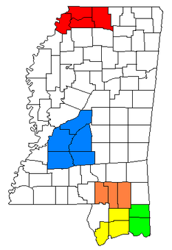
Memphis Metropolitan Area The Memphis Metropolitan Statistical Area, TN-MS-AR , more commonly known as The Mid-South, is the 41st largest among similarly designated areas in the United States. The metropolitan area covers eight counties in three states – Tennessee, Mississippi, and Arkansas...
Pascagoula metropolitan area The Pascagoula Metropolitan Statistical Area is a metropolitan area in the southeastern corner of Mississippi that covers two counties - Jackson and George. As of the 2000 census, the MSA had a population of 150,564. The area was significantly impacted by Hurricane Katrina in 2005. A July 1, 2009...
|
Population statistics
| Metropolitan Statistical Area | July 1, 2009 Estimate |
2000 Census |
Growth Rate (2000–2009) |
|---|---|---|---|
| Jackson MSA Jackson metropolitan area The Jackson Metropolitan Statistical Area is a metropolitan area in the central region of the U.S. state of Mississippi that covers five counties: Copiah, Hinds, Madison, Rankin, and Simpson. As of the 2000 census, the MSA had a population of 497,197... |
540,866 | 497,197 | 8.78% |
| Gulfport-Biloxi MSA Gulfport-Biloxi metropolitan area The Gulfport-Biloxi Metropolitan Statistical Area is a metropolitan area in the Mississippi Gulf Coast region that covers three counties - Hancock, Harrison, and Stone. As of the 2000 census, the MSA had a population of 246,190. The area was significantly impacted by Hurricane Katrina in 2005. A... 1 |
238,772 | 246,190 | –3.01% |
| Memphis, TN-AR-MS MSA Memphis Metropolitan Area The Memphis Metropolitan Statistical Area, TN-MS-AR , more commonly known as The Mid-South, is the 41st largest among similarly designated areas in the United States. The metropolitan area covers eight counties in three states – Tennessee, Mississippi, and Arkansas... 2 |
233,392 | 176,789 | 32.02% |
| Pascagoula MSA Pascagoula metropolitan area The Pascagoula Metropolitan Statistical Area is a metropolitan area in the southeastern corner of Mississippi that covers two counties - Jackson and George. As of the 2000 census, the MSA had a population of 150,564. The area was significantly impacted by Hurricane Katrina in 2005. A July 1, 2009... 1 |
155,603 | 150,564 | 3.35% |
| Hattiesburg MSA Hattiesburg metropolitan area The Hattiesburg Metropolitan Statistical Area is a metropolitan area in southeastern Mississippi that covers three counties - Forrest, Lamar, and Perry... |
143,093 | 123,812 | 15.57% |
| 1 The Gulfport-Biloxi and Pascagoula metropolitan areas were significantly impacted by Hurricane Katrina Effect of Hurricane Katrina on Mississippi Hurricane Katrina's winds and storm surge reached the Mississippi coastline on the afternoon of August 28, 2005,beginning a two-day path of destruction through central Mississippi; by 10 a.m. CDT on August 29, 2005, the eye of Katrina began travelling up the entire state, only slowing from... in 2005. Prior to the hurricane, both areas had experienced steady to moderate population growth. 2 Population figures are for the five Mississippi counties in the Memphis MSA only. |
|||
Combined Statistical Areas
United States Census Bureau
The United States Census Bureau is the government agency that is responsible for the United States Census. It also gathers other national demographic and economic data...
defines a Combined Statistical Area
Combined Statistical Area
The United States Office of Management and Budget defines micropolitan and metropolitan statistical areas. Metropolitan and micropolitan statistical areas consist of one or more counties...
(CSA) as an aggregate of adjacent Core Based Statistical Area
Core based statistical area
A Core Based Statistical Area is a U.S. geographic area defined by the Office of Management and Budget based around an urban center of at least 10,000 people and adjacent areas that are socioeconomically tied to the urban center by commuting. Areas defined on the basis of these standards applied...
s (CBSAs) that are linked by commuting ties. There are three combined statistical areas in Mississippi.
|
Population statistics
| Combined Statistical Area | July 1, 2009 Estimate |
2000 Census |
Growth Rate (2000–2009) |
|---|---|---|---|
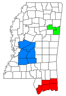
| Jackson-Yazoo City CSA Jackson-Yazoo City combined statistical area The Jackson-Yazoo City Combined Statistical Area is made up of six counties in central Mississippi. The statistical area consists of the Jackson Metropolitan Statistical Area and the Yazoo City Micropolitan Statistical Area. As of the 2000 census, the CSA had a population of 525,346... |
568,847 | 525,346 | 8.28% |
| Gulfport-Biloxi-Pascagoula CSA Gulfport-Biloxi-Pascagoula combined statistical area The Gulfport-Biloxi-Pascagoula Combined Statistical Area is made up of five counties in the Mississippi Gulf Coast region. The statistical area consists of the Gulfport-Biloxi Metropolitan Statistical Area and the Pascagoula Metropolitan Statistical Area. As of the 2000 census, the CSA had a... 1 |
394,375 | 396,754 | –0.60% |
| Columbus-West Point CSA Columbus-West Point combined statistical area The Columbus-West Point Combined Statistical Area is made up of two counties in northeastern Mississippi. The statistical area consists of the Columbus Micropolitan Statistical Area and the West Point Micropolitan Statistical Area... |
80,380 | 83,565 | –3.81% |
| 1 The Gulfport-Biloxi-Pascagoula CSA was significantly impacted by Hurricane Katrina Effect of Hurricane Katrina on Mississippi Hurricane Katrina's winds and storm surge reached the Mississippi coastline on the afternoon of August 28, 2005,beginning a two-day path of destruction through central Mississippi; by 10 a.m. CDT on August 29, 2005, the eye of Katrina began travelling up the entire state, only slowing from... in 2005. Prior to the hurricane, the area had experienced steady to moderate population growth. |
|||
See also
- List of micropolitan areas in Mississippi
- List of cities in Mississippi
- List of towns and villages in Mississippi
- Mississippi census statistical areasMississippi census statistical areasThe United States Census Bureau has defined 3 Combined Statistical Areas , 5 Metropolitan Statistical Areas , and 20 Micropolitan Statistical Areas in the State of Mississippi. The following table describes these areas with the following information:*The name of the Combined Statistical Area , if...
- Table of United States primary census statistical areas (PCSA)
- Table of United States Combined Statistical AreasTable of United States Combined Statistical Areasthumb|An enlargeable map of the 125 [[Combined Statistical Area]]s of the [[United States]]The United States Office of Management and Budget has defined 125 Combined Statistical Areas for the United States of America...
(CSA) - Table of United States Metropolitan Statistical AreasTable of United States Metropolitan Statistical Areasthumb|An enlargeable map of the 942 [[Core Based Statistical Area]]s of the [[United States]]. The 367 [[Metropolitan Statistical Area]]s are shown in red....
(MSA) - Table of United States Micropolitan Statistical AreasTable of United States Micropolitan Statistical Areasthumb|An enlargeable map of the 942 [[Core Based Statistical Area]]s of the [[United States]]. The 576 [[Micropolitan Statistical Area]]s are shown in blue....
(μSA)