

List of hill forts in Wales
Encyclopedia
Wales
Wales is a country that is part of the United Kingdom and the island of Great Britain, bordered by England to its east and the Atlantic Ocean and Irish Sea to its west. It has a population of three million, and a total area of 20,779 km²...
.
AngleseyAngleseyAnglesey , also known by its Welsh name Ynys Môn , is an island and, as Isle of Anglesey, a county off the north west coast of Wales...
- Caer y TwrCaer y TŵrCaer y Twr was a Roman-era hillfort atop the summit of the Holyhead Mountain in Anglesey, Wales. The hillfort, which is situated among rocky outcrops, is ideally placed for defence and likely served as a watchtower and possibly as a signal tower...
- Castell Bryn GwynCastell Bryn GwynCastell Bryn Gwyn is a prehistoric site on the Isle of Anglesey, west of Brynsiencyn. It is a circular clay and gravel bank covered with grass, still some 1.5m high and revetted externally by stone walls, which surround a level area some 54 metres in diameter. Its name means "White Hill Castle".The...
- Din Sylwy (Bwrdd Arthur)
- Dinas Gynfor, near LlanbadrigLlanbadrigLlanbadrig is a parish in the cwmwd of Talybolion, on the island of Anglesey, north Wales. The parish includes the township of Clygyrog and the little port of Cemaes . The region has extensive quarries of limestone and marble....
CarmarthenshireCarmarthenshireCarmarthenshire is a unitary authority in the south west of Wales and one of thirteen historic counties. It is the 3rd largest in Wales. Its three largest towns are Llanelli, Carmarthen and Ammanford...
- Carn Goch
- Castell Pen y Coed, near LlanddowrorLlanddowrorLlanddowror is a small, historic, relatively unspoilt village 2 miles from the town of St. Clears in Carmarthenshire in West Wales.- History & Amenities :...
- Llansteffan CastleLlansteffan CastleLlansteffan Castle is a castle overlooking the River Tywi as it enters Carmarthen Bay near the village of Llansteffan in Carmarthenshire, Wales.- Prehistoric site :...
, near CarmarthenCarmarthenCarmarthen is a community in, and the county town of, Carmarthenshire, Wales. It is sited on the River Towy north of its mouth at Carmarthen Bay. In 2001, the population was 14,648.... - Merlin's Hill (Bryn Myrddin)CarmarthenCarmarthen is a community in, and the county town of, Carmarthenshire, Wales. It is sited on the River Towy north of its mouth at Carmarthen Bay. In 2001, the population was 14,648....
- Top Castle, EglwyscumminEglwyscumminEglwyscummin is a Community Ward about southeast of Whitland in Carmarthenshire. It incorporates Marros, Cyfig and the village of Red Roses. It consists mostly of farmland and is crossed by a main road route to the once popular holiday resort of Pendine Sands and the main route to south...
CeredigionCeredigionCeredigion is a county and former kingdom in mid-west Wales. As Cardiganshire , it was created in 1282, and was reconstituted as a county under that name in 1996, reverting to Ceredigion a day later...
- Craig Gwrtheyrn, near LlandysulLlandysulLlandysul is a small town in the county of Ceredigion, Wales. The community of Pont Tyweli lies directly across the Teifi River in Carmarthenshire. It is in the valley of the River Teifi and is visited for its fishing and canoeing....
- Esgair Nantyrarian, near Devil's BridgeDevil's BridgeDevil’s Bridge is a term applied to dozens of ancient bridges, found primarily in Europe. Most of these bridges are stone or masonry arch bridges and represent a significant technological achievement...
- Hen Gaer
- Pen DinasPen DinasPen Dinas is the name of a hill south of Aberystwyth on the coast of Ceredigion, Wales, upon which an extensive Iron Age hill fort is situated....
- Pen Dinas Lochdyn, near LlangrannogLlangrannogLlangrannog is a small, coastal village and seaside resort in Ceredigion, Wales, seven miles south of New Quay. According to the United Kingdom Census 2001, the population of Llangrannog was then 796 people...
- Pen y Ffrwd Llwyd, near Ystrad MeurigYstrad MeurigYstrad Meurig is a village in Ceredigion, Wales. It lies on the B4340 road northwest of the town of Tregaron.- History & Amenities :...
- Pencoed y Foel
- Trawscoed fortTrawscoed fortTrawscoed fort is an iron-age auxiliary hill fort in Ceredigion, Wales, located near the modern town of Trawsgoed that was first built in the 70s AD. It overlooks the Roman bridge over the river Ystwyth, which is where the road from Pen-Ilwyn to Llanio crosses. In 1959, this site was initially...
ClwydClwydClwyd is a preserved county of Wales, situated in the north-east, bordering England with Cheshire to its east, Shropshire to the south-east, and the Welsh counties of Gwynedd to its immediate west and Powys to the south. It additionally shares a maritime border with the metropolitan county of...
- Allt Wen
- Bryn AlynBryn AlynBryn Alyn is a hill and Site of Special Scientific Interest in Denbighshire, North Wales, and forms part of the Clwydian Range Area of Outstanding Natural Beauty. Bryn Alyn lies to the east of the River Alyn, with the valley of Dyffryn Alyn separating it from the main range of the Clwydian hills...
- Bryn EurynBryn EurynBryn Euryn is a mountain which is a Site of Special Scientific Interest in the preserved county of Clwyd, north Wales; .- External link:*...
- Caer BachRowen, ConwyRowen is a small village on the western slopes of the Conwy valley in Conwy county borough, north Wales. It lies off the B5106 road, between Dolgarrog and Conwy....
- Caer Drewyn, near CorwenCorwenCorwen is a town and community in the county of Denbighshire in Wales; it was previously part of the county of Meirionnydd). Corwen stands on the banks of the River Dee beneath the Berwyn mountains. The town is situated west of Llangollen and south of Ruthin...
- Caer SeionMynydd y DrefMynydd y Dref or Conwy Mountain is a hilly area to the west of the town of Conwy, in North Wales. To the north it overlooks the sea of Conwy Bay, and to the south lie the foothills of the Carneddau range of Mountains, of which it forms a part...
- Castell CawrTan-y-GopaTan-y-Gopa is a heavily forested hill above the town of Abergele in Conwy county borough, Wales. On it is found the Iron Age hill fort Castell Cawr and caves where rare lesser horseshoe bats live. The woods are owned by the Woodland Trust. The hill rises to about 180 m above sea level.-External...
- Castell Dinas BranCastell Dinas BranCastell Dinas Brân is a medieval castle standing high on a hill above the town of Llangollen in Denbighshire, Wales. It is also the site of an Iron Age hill fort.-Early history:...
, near LlangollenLlangollenLlangollen is a small town and community in Denbighshire, north-east Wales, situated on the River Dee and on the edge of the Berwyn mountains. It has a population of 3,412.-History:... - Cerrig y Ddinas
- Moel ArthurClwydian RangeThe Clwydian Range is a series of hills and mountains in north east Wales that runs from Llandegla in the south to Prestatyn in the north, with the highest point being the popular Moel Famau...
- Moel Fenlli near RuthinRuthinRuthin is a community and the county town of Denbighshire in north Wales. Located around a hill in the southern part of the Vale of Clwyd - the older part of the town, the castle and Saint Peter's Square are located on top of the hill, while many newer parts of the town are on the floodplain of...
- Moel y GaerMoel y Gaer, BodfariMoel y Gaer is a prehistoric hill fort at the northern end of the Clwydian Range, located on a summit overlooking the valley of the River Wheeler, near the village of Bodfari, Denbighshire, Wales...
, near BodfariBodfariBodfari is a village in Denbighshire, Wales.- Location :Bodfari is located at approximate grid reference SJ093701. The village lies on the A541 road at the point where the road passes through a gap in the Clwydian Hills, the gap being part of the valley of the River Wheeler .The Offa's Dyke... - Moel y GaerMoel y Gaer, LlanbedrMoel y Gaer is an Iron Age hill fort located on a western spur of the Clwydian Range, near the village of Llanbedr, Denbighshire, Wales....
, near LlanbedrLlanbedrLlanbedr is a village in the Ardudwy area of Gwynedd, Wales.The village originally grew around the slate quarrying industry. Attractions in Llanbedr include Neolithic standing stones and Bronze Age hut circles. The Morfa Dyffryn sand dunes and Mochras lie nearby... - Moel y GaerMoel y Gaer, LlantysilioMoel y Gaer is an Iron Age hill fort on a summit of Llantysilio Mountain, northwest of the town of Llangollen, Denbighshire, Wales....
, on Llantysilio Mountain - Moel y GaerMoel y Gaer, RhosesmorMoel y Gaer is a prehistoric hill fort located on a summit of Halkyn Mountain, overlooking the village of Rhosesmor, Flintshire, Wales....
, near RhosesmorRhosesmorRhosesmor is a small village near Mold, Flintshire, in north-east Wales. The village lies near the parishes of Halkyn and Rhes-y-cae. The hamlet of Wern-y-Gaer is encompassed by the boundaries of the village.- History :... - Pen y Castell, near MaenanMaenanMaenan is a rural community in Conwy, Wales, located approximately 4 miles to the north of Llanrwst and 3 miles to the south of the village of Eglwysbach. The population of the area is approximately 300 people, and more than 75% of the population are Welsh speakers. Maenan shares a community...
- PenycloddiauPenycloddiauPenycloddiau is a hill in Denbighshire, North Wales and is the northernmost marilyn in the Clwydian Range.Offa's Dyke Path crosses the summit, and the Clwydian Way skirts the western slopes. Like Foel Fenlli further south, Penycloddiau has an iron-age hill fort around the summit area...
- Pen y Corddyn Mawr
- Pen y GaerPen y GaerPen y Gaer is the location of a Bronze Age hill fort near the village of Llanbedr-y-Cennin in the Conwy valley in North Wales....
, Llanbedr-y-cenninLlanbedr-y-CenninLlanbedr-y-Cennin is a small village in Conwy county borough, Wales.It lies in the foothills on the western side of the Conwy valley, in North Wales. The river Conwy runs through the valley, running into the sea to the north, at the town of Conwy, which is about five miles north of the village. ...
, Conwy Valley - Y Gardden
GlamorganGlamorganGlamorgan or Glamorganshire is one of the thirteen historic counties and a former administrative county of Wales. It was originally an early medieval kingdom of varying boundaries known as Glywysing until taken over by the Normans as a lordship. Glamorgan is latterly represented by the three...
- The Bulwark, Gower PeninsulaGower PeninsulaGower or the Gower Peninsula is a peninsula in south Wales, jutting from the coast into the Bristol Channel, and administratively part of the City and County of Swansea. Locally it is known as "Gower"...
- Burry HolmsBurry HolmsBurry Holms is a small tidal island located at the northern end of the Gower Peninsula, Wales. 9,000 years ago it was up to 12 miles away from the sea and inhabited by nomadic Mesolithic hunters...
, Gower PeninsulaGower PeninsulaGower or the Gower Peninsula is a peninsula in south Wales, jutting from the coast into the Bristol Channel, and administratively part of the City and County of Swansea. Locally it is known as "Gower"... - Caerau, CardiffCardiffCardiff is the capital, largest city and most populous county of Wales and the 10th largest city in the United Kingdom. The city is Wales' chief commercial centre, the base for most national cultural and sporting institutions, the Welsh national media, and the seat of the National Assembly for...
- Caerau, Rhiwsaeson
- Dinas Powys (Cwrt-yr-ala)Dinas Powys hillfortThe Dinas Powys hill fort is an Iron Age hill fort located in Cwrt-yr-Ala Park, a half-a-mile north of the village of Dinas Powys in Glamorgan, south Wales. It is just one of several thousand hillforts to have been constructed around Britain during the British Iron Age, for reasons that are still...
, near CardiffCardiffCardiff is the capital, largest city and most populous county of Wales and the 10th largest city in the United Kingdom. The city is Wales' chief commercial centre, the base for most national cultural and sporting institutions, the Welsh national media, and the seat of the National Assembly for... - Graig Llwyn
- Llwynda-ddu, PentyrchPentyrchPentyrch is a suburban community located on the western outskirts of Cardiff, the capital city of Wales. The village gives its name to a Cardiff local authority electoral ward, which covers the village and surrounding area.-Geography:...
GwentGwent (county)Gwent is a preserved county and a former local government county in south-east Wales. It was formed on 1 April 1974, under the Local Government Act 1972, and was named after the ancient Kingdom of Gwent....
- Gaer Fawr, LlangwmLlangwm, MonmouthshireLlangwm is a small rural parish and village in Monmouthshire, south east Wales, United Kingdom. It is located 3 miles east of Usk, on the B4235 Chepstow to Usk road. The main village is at Llangwm Uchaf , with a smaller and more dispersed settlement about 1 mile to the north-east at Llangwm Isaf...
- Llanmelin, Llanvair DiscoedLlanvair DiscoedLlanvair Discoed is a small village in Monmouthshire, south-east Wales, 6 miles west of Chepstow and 10 miles east of Newport.-History:The village is mentioned in the Domesday Book of 1086 as 'Lamecare'. The name means Mary's church under the wood . The 'd' at the start of Discoed only appears...
- Sudbrook Camp
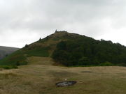
- TwmbarlwmTwmbarlwmTwmbarlwm also known as Twm Barlwm, Twyn Barlwm, or locally known as "The tump" in relation to the mound that lies on its summit, is a mountain situated 2 km to the northeast of Risca in South Wales. It is high and is a well known sight throughout the region...
- Wilcrick HillWilcrickWilcrick is a small village within the administrative boundary of the city of Newport, South Wales, just to the west of Magor. It is within the historic county of Monmouthshire.The name translates from the Welsh as "bare hill"...
GwyneddGwyneddGwynedd is a county in north-west Wales, named after the old Kingdom of Gwynedd. Although the second biggest in terms of geographical area, it is also one of the most sparsely populated...
- Bryn y Castell, near Llan FfestiniogLlan FfestiniogLlan Ffestiniog, also known as Ffestiniog or simply Llan is a village in Gwynedd , north Wales, lying south of Blaenau Ffestiniog....
- Caer Euni
- Castell Odo
- Craig y Dinas, near Dyffryn ArdudwyDyffryn ardudwyDyffryn Ardudwy is a village and community in the Ardudwy area of Gwynedd, Wales. It has a population of 1,654.The village of Dyffryn Ardudwy is situated on the A496 costal road between the towns of Harlech and Barmouth and at the foot of Moelfre, part of the Rhinogydd range.There are a number of...
- Craig yr AderynCraig yr AderynCraig yr Aderyn, , is a hill rising to a height of over above sea level on the south bank of the River Dysynni near Llanfihangel-y-pennant in the county of Gwynedd, north-west Wales....
- Dinas DinlleDinas DinlleDinas Dinlle is a small settlement in Gwynedd, north-west Wales, with a large sand and pebble beach with vast areas of sand from mid-tide level. The foreshore consists of natural pebble banks. The popular beach offers views towards the Llŷn Peninsula and towards Ynys Llanddwyn on Anglesey...
- Dinas Dinorwig, near Llanddeiniolen
- Dinas EmrysDinas EmrysDinas Emrys is a rocky and wooded hillock near Beddgelert in Gwynedd, north-west Wales. Rising some 250 ft above the floor of the Glaslyn river valley, it overlooks the southern end of Llyn Dinas in Snowdonia. Little remains of the castle structures that once stood here, save its stone...
, near BeddgelertBeddgelertBeddgelert, or in older English spelling often Bedgellert, is a village and community in the Snowdonia area of Gwynedd, Wales. It is reputed to be named after the legendary hound Gelert. Population 617.- History:... - Garn BoduanGarn BoduanGarn Boduan is an Iron Age hill fort near Nefyn, on the Llŷn Peninsula in Wales.In a survey in the 1950s the traces of over 170 round houses were identified on this site, and around 100 round houses are still visible on the ground. Between 100 and 400 people may have lived in this fort. The lower...
- Garn Fadryn, Llyn PeninsulaLlyn PeninsulaThe Llŷn Peninsula extends into the Irish Sea from north west Wales, south west of the Isle of Anglesey. It is part of the modern county and historic region of Gwynedd. The name is thought to be of Irish origin, and to have the same root Laigin in Irish as the word Leinster...
- Mynydd y Graig (Creigiau Gwineu)
- Pen y Dinas, near TalybontTalybont, BarmouthTalybont is a village north of the town of Barmouth in mid Wales.Talybont benefits from a railway station on the Cambrian Line and has many caravan sites, a hair dressers a village shop, a pub called the 'Ysgeithin Inn' and a restaurant.It is also home to the annual Dyffryn and Talybont Fun day,...
- Tre'r Ceiri, Yr EiflYr EiflYr Eifl is a mountain on the north coast of the Llŷn peninsula in Gwynedd, north-western Wales.It has three summits, each quite separate from the others, and this is often supposed to be the source of the English name The Rivals...
PembrokeshirePembrokeshirePembrokeshire is a county in the south west of Wales. It borders Carmarthenshire to the east and Ceredigion to the north east. The county town is Haverfordwest where Pembrokeshire County Council is headquartered....
- Carn Ingli
- Castell HenllysCastell HenllysCastell Henllys is an important archaeological site in north Pembrokeshire, Wales, between Newport and Cardigan....
- Foel DrygarnPreseli HillsThe Preseli Hills or Preseli Mountains are a range of hills in north Pembrokeshire, West Wales...
- Porth y Rhaw, near SolvaSolvaSolva is a village and community in Pembrokeshire, Wales, UK.-Location:Solva lies on the north side of St Bride's Bay, in North Pembrokeshire in the Pembrokeshire Coast National Park and on the Pembrokeshire Coast Path. It lies on a deep ravine at the mouth of the River Solva. In the ravine is...
- St. David's Head
PowysPowysPowys is a local-government county and preserved county in Wales.-Geography:Powys covers the historic counties of Montgomeryshire and Radnorshire, most of Brecknockshire , and a small part of Denbighshire — an area of 5,179 km², making it the largest county in Wales by land area.It is...
- Allt yr EsgairAllt yr EsgairAllt yr Esgair is a hill in the Brecon Beacons National Park in the county of Powys, south Wales. It is commonly referred to locally as simply 'The Allt'. The Welsh name signifies 'wooded slope of the ridge'. It takes the form of a northwest-southeast aligned ridge which rises to a height of 393m...
- Beacon RingLong Mountain (Powys)The Long Mountain is a hill to the east of Welshpool in Powys, Wales. It rises to a height of 408m at Beacon Ring, where there is a hill fort.The Long Mountain extends from Forden in the southwest to Vennington in Shropshire to the northeast...
- BreiddinBreidden HillBreidden Hill is an extinct volcanic hill, located on the border between Shropshire, England and Powys, Wales, near the town of Llandrinio. The peak of the hill reaches to 1199 ft...
- Burfa CampBurfa CastleBurfa Castle was a hillfort defensive fortification near the tiny town of Old Radnor in Radnorshire , Wales. It lies near the Burfa Bog Nature Reserve and an Iron Age barrow. Little remains of the hillfort today save a ditch above a steep bank...
- Castell DinasCastell DinasCastell Dinas is a hillfort and castle in southern Powys, Wales. At 450 m it has the highest castle in England and Wales. It is positioned to defend the Rhiangoll pass between Talgarth and Crickhowell....
, TalgarthTalgarthTalgarth is a small market town and community in southern Powys , Mid Wales, with a population of 1,645. Notable buildings in the town include its 14th-century parish church and 13th century Pele Tower, located in the town centre, now home to the Tourist Information and Resource Centre... - Castle Bank, near Gilwern HillGilwern Hill, PowysGilwern Hill is a hill about 3 mi / 5 km southeast of Llandrindod Wells in the county of Powys, Wales.-Geology:The hill is composed from a range of lower and middle Ordovician volcaniclastic rocks which form a part of the Builth Inlier...
- Cefn Carnedd, near CaerswsCaerswsCaersws is a village and community sitting on the River Severn, at miles west of Newtown, Powys, and halfway between Aberystwyth and Shrewsbury.- History & Amenities :...
- Craig Rhiwarth, near LlangynogLlangynogLlangynog lies at the confluence of the Afon Eirth and the Afon Tanat at the foot of the Berwyn range in Powys, Wales. Pop c.300It lies at the foot of the Milltir Cerrig mountain pass on the B4391 road, which runs between Llan Ffestiniog and Llanfyllin .It is surrounded by mountains and is a...
- Crug HywelCrug HywelCrug Hywel is a flat-topped hill at the southern edge of the Black Mountains in south-east Wales.It rises to 451 m above sea level, from the southern flank of Pen Cerrig-calch , and overlooks the town of Crickhowell , to which it gives its name.The summit of the hill is entirely taken up by...
, CrickhowellCrickhowellCrickhowell is a small town in Powys, Mid Wales.-Location:The name Crickhowell is taken from that of the nearby Iron Age hill fort of Crug Hywel above the town, the Welsh language name being anglicised by map-makers and local English-speaking people... - Ffridd FaldwynMontgomery-In France:* Sainte-Foy-de-Montgommery, a commune in département Calvados, Normandy* Saint-Germain-de-Montgommery, idem* Colleville-Montgomery, idem-In Pakistan:...
- Gaer Fawr, GuilsfieldGuilsfieldGuilsfield is a village and local government community in Powys, Wales. It lies beside Guilsfield Brook about three miles north of Welshpool. It is located on the B4392 road and a disused branch of the Montgomery Canal starts nearby...
- Llanymynech HillLlanymynechLlanymynech is a village straddling the border between Montgomeryshire/Powys, Wales and Shropshire, England about 9 miles north of the Welsh town of Welshpool. The name is Welsh for "Church of the Monks"....
- Llwyn Bryn Dinas, near LlangedwynLlangedwynLlangedwyn is a village in Powys, Wales at .It lies in the Tanat Valley near to the Wales/England border. It is approximately five miles from the small town of Llanfyllin and ten miles from the Shropshire market town of Oswestry. The Berwyn mountain range is nearby, as is Pistyll Rhaeadr waterfall...
- Pen y Clun, near LlanidloesLlanidloesLlanidloes is a town along the A470 road and B4518 road in Powys, within the historic county boundaries of Montgomeryshire , Mid Wales.It is the first town on the River Severn...
- Pen-y-crugPen-y-crugPen-y-crug is a hill in the Brecon Beacons National Park in the county of Powys, south Wales. It is commonly referred to locally as simply 'The Crug' . The Welsh name signifies 'top of the mound'. It slopes are moderately gently on three sides; only to the west do they steepen somewhat...
, near BreconBreconBrecon is a long-established market town and community in southern Powys, Mid Wales, with a population of 7,901. It was the county town of the historic county of Brecknockshire; although its role as such was eclipsed with the formation of Powys, it remains an important local centre... - Pen y Gaer, near LlanidloesLlanidloesLlanidloes is a town along the A470 road and B4518 road in Powys, within the historic county boundaries of Montgomeryshire , Mid Wales.It is the first town on the River Severn...
- Roundton Hill
- Slwch Camp, near BreconBreconBrecon is a long-established market town and community in southern Powys, Mid Wales, with a population of 7,901. It was the county town of the historic county of Brecknockshire; although its role as such was eclipsed with the formation of Powys, it remains an important local centre...
- Twyn y GaerGaer (Black Mountains)Gaer is the name of a hill in the Black Mountains of the Brecon Beacons National Park in Monmouthshire, south Wales. It lies at the southern end of the long ridge between the valley of the Grwyne Fawr and the Vale of Ewyas one mile to the north of Bryn Arw and 3 miles northeast of Sugarloaf. Its...