
.gif)
List of county routes in Rockland County, New York (1-38)
Encyclopedia
Rockland County, New York
Rockland County is a suburban county 15 miles to the northwest of Manhattan and part of the New York City Metropolitan Area, in the U.S. state of New York. It is the southernmost county in New York west of the Hudson River, and the smallest county in New York outside of New York City. The...
highway department. Across the county, routes are numbered such that odd-numbered routes are north–south and increase in number from east to west, while even-numbered routes are east–west and increase from south to north.
There are 24 routes in this segment, the lowest being Route 1 and the highest being Route 38. The farthest north route is Route 33 in Stony Point, while the farthest south is Route 4 in Palisades. The farthest west is Route 30 in Pearl River and the farthest east is Route 1 in Grand View-on-Hudson. The longest route is Route 33, stretching for 13.4 miles (21.6 km) while the shortest route is Route 33A at a short, .1 of a mile.
| Rockland (NY) County Routes (1–38) |
|---|
| CR 1 • CR 4 • CR 5 • CR 8 • CR 11 • CR 13 • CR 15 • CR 16 • CR 17 • CR 20 • CR 22 • CR 23 • CR 26 • CR 27 • CR 28 • CR 29 • CR 30 • CR 33 • CR 33A • CR 35 • CR 35A • CR 36 • CR 37 • CR 38 |
| Other lists: CRs 41–75 • CRs 76–118A |
Route 1
County Route 1 is a 1.6 miles (2.6 km) south–north county route in the eastern part of Rockland County.Route 1 begins at the Piermont village line, and ends at the South Nyack village line. CR 1 runs through Grand View-on-Hudson
Grand View-on-Hudson, New York
Grand View-on-Hudson is a village in Rockland County, New York, United States located north of Piermont; east of Orangeburg; south of South Nyack and west of the Hudson River. The population, one of the most affluent incorporated communities in the United States, was 284 at the 2000 census. The...
. CR 1 runs parallel to US 9W
U.S. Route 9W
U.S. Route 9W is a north–south U.S. Highway in the states of New Jersey and New York. It begins on Fletcher Avenue in Fort Lee, New Jersey as it crosses the US 1 & 9, US 46, and the Interstate 95 approaches to the George Washington Bridge, where it heads north up the west...
for the duration of its run. CR 1 gives the driver a beautiful view as runs right along the western banks of the Hudson River
Hudson River
The Hudson is a river that flows from north to south through eastern New York. The highest official source is at Lake Tear of the Clouds, on the slopes of Mount Marcy in the Adirondack Mountains. The river itself officially begins in Henderson Lake in Newcomb, New York...
. CR 1's northern terminus is just north of the Tappan Zee Bridge
Tappan Zee Bridge
The Governor Malcolm Wilson Tappan Zee Bridge, usually referred to as Tappan Zee Bridge, is a cantilever bridge in New York over the Hudson River at one of its widest points; the Tappan Zee is named for an American Indian tribe from the area called "Tappan"; and zee being the Dutch word for "sea"....
overpass, which carries the New York State Thruway
New York State Thruway
The New York State Thruway is a system of limited-access highways located within the state of New York in the United States. The system, known officially as the Governor Thomas E. Dewey Thruway for former New York Governor Thomas E. Dewey, is operated by the New York State Thruway Authority and...
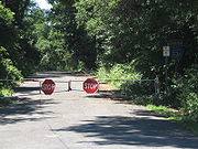
(I-87/I-287). CR 1 does not intersect any major roads during its run as it does not enter the village limits of Nyack or Piermont. In fact, CR 1 does not intersect any roads at all during its run, as it is only connected to Nyack and Piermont via the roads that continue on after the route's termini.
Route 4
County Route 4 is a 0.75 miles (1.2 km) west–east county route in the southern part of Rockland County, New YorkRockland County, New York
Rockland County is a suburban county 15 miles to the northwest of Manhattan and part of the New York City Metropolitan Area, in the U.S. state of New York. It is the southernmost county in New York west of the Hudson River, and the smallest county in New York outside of New York City. The...
.
Route 4 begins at the New Jersey border in Palisades and Rockleigh, New Jersey
Rockleigh, New Jersey
Rockleigh is a borough in Bergen County, New Jersey, United States. As of the United States 2010 Census, the borough population was 531.Rockleigh was incorporated as a borough by an Act of the New Jersey Legislature on March 13, 1923 from portions of Northvale.New Jersey Monthly magazine ranked...
, and ends at US 9W. CR 4 is located in Palisades. CR 4 crosses the Palisades Interstate Parkway
Palisades Interstate Parkway
The Palisades Interstate Parkway is a long limited-access highway in the U.S. states of New Jersey and New York. The parkway is a major commuter route into New York City from Rockland and Orange counties in New York and Bergen County in New Jersey...
, but does not intersect it. CR 4 is the southernmost Rockland County Route. The route does not intersect any other Rockland County Routes, and only a few CR 4 shields stand along the route. One junction shield stands on US 9W, and two at the New Jersey border with none in between.
Route 5
County Route 5 is a 3.88 miles (6.2 km) south–north county route in the eastern part of Rockland County, New YorkRockland County, New York
Rockland County is a suburban county 15 miles to the northwest of Manhattan and part of the New York City Metropolitan Area, in the U.S. state of New York. It is the southernmost county in New York west of the Hudson River, and the smallest county in New York outside of New York City. The...
.
Route 5 begins at US 9W in Piermont, and ends at CR 38 in Nyack. CR 5 runs through less developed areas of Piermont and Nyack. The first stretches of CR 5 runs parallel to US 9W, which is a very narrow, one-lane road without yellow center lines that carries two-way traffic. During this stretch, CR 5 provides the driver with an excellent view of the Hudson River and Piermont, which is much lower in elevation than CR 5. In this area there is a junction with Nike Lane, which leads to a disused Nike missile base and a county park. At its intersection with CR 28, CR 5 enters Blauvelt State Park where it runs until its northern terminus at CR 38 near Nyack College
Nyack College
Nyack College is a private, evangelical, liberal arts college affiliated with the Christian and Missionary Alliance and home to the Alliance Theological Seminary, one of the denomination's seminaries. The main campus is located in Nyack, New York...
.
Route 8
County Route 8 is a 1.9 miles (3.1 km) west–east county route in the southern part of Rockland County, New YorkRockland County, New York
Rockland County is a suburban county 15 miles to the northwest of Manhattan and part of the New York City Metropolitan Area, in the U.S. state of New York. It is the southernmost county in New York west of the Hudson River, and the smallest county in New York outside of New York City. The...
.
Route 8 begins at the New Jersey border in Tappan and Northvale, New Jersey
Northvale, New Jersey
Northvale is a borough in Bergen County, New Jersey, United States. As of the 2010 United States Census, the borough population was 4,640.Northvale was formed on March 15, 1916, from the remaining portions of Harrington Township, based on the results of a referendum held on April 4, 1916. With the...
, and ends at NY 340 in Sparkill. CR 8 runs through Tappan and Sparkill. CR 8 crosses NY 303
New York State Route 303
New York State Route 303 is a north–south state highway in eastern Rockland County, New York, in the United States. It begins at the New Jersey state line in the hamlet of Tappan and ends later at an intersection with U.S. Route 9W in Clarkstown...
and the Palisades Interstate Parkway
Palisades Interstate Parkway
The Palisades Interstate Parkway is a long limited-access highway in the U.S. states of New Jersey and New York. The parkway is a major commuter route into New York City from Rockland and Orange counties in New York and Bergen County in New Jersey...
, but does not intersect either of them. CR 8 is the only Rockland County Route to intersect with NY 340. Before CR 15 was extended to the New York/New Jersey border via Main Street, in Tappan, CR 8 used to travel along this route ending at the state border. CR 8 passes through historic Tappan, which has many historical Revolutionary War
American Revolutionary War
The American Revolutionary War , the American War of Independence, or simply the Revolutionary War, began as a war between the Kingdom of Great Britain and thirteen British colonies in North America, and ended in a global war between several European great powers.The war was the result of the...
landmarks. CR 8's eastern terminus in Sparkill is unsigned.
Route 11
County Route 11 is a 2.74 miles (4.4 km) south–north county route in the eastern part of Rockland County, New YorkRockland County, New York
Rockland County is a suburban county 15 miles to the northwest of Manhattan and part of the New York City Metropolitan Area, in the U.S. state of New York. It is the southernmost county in New York west of the Hudson River, and the smallest county in New York outside of New York City. The...
.
Route 11 begins at Mountainview Avenue in Orangeburg, and ends at the Clarkstown townline in West Nyack.
CR 11 runs through the villages of Orangeburg and Blauvelt. CR 11 is an alternate for NY 303
New York State Route 303
New York State Route 303 is a north–south state highway in eastern Rockland County, New York, in the United States. It begins at the New Jersey state line in the hamlet of Tappan and ends later at an intersection with U.S. Route 9W in Clarkstown...
for its entire run, and even runs with NY 303 for 0.2 mile (0.321868 km). That is because CR 11 is pushed west due to running along the western border of Blauvelt State Park
Blauvelt State Park
Blauvelt State Park is located in the Town of Orangetown in Rockland County, New York, not far from the Hudson River. The park is south of Nyack, New York.This is an undeveloped park with no facilities other than hiking trails and limited parking...
. In fact, CR 11 borders several protected areas including Clausland Mountain County Park, Tackamack Park, and Blauvelt State Park during its run. CR 11 ends at the Clarkstown townline, but Greenbush Road continues north. It passes yet another park in Buttermilk Falls County Park, before passing NY 59
New York State Route 59
New York State Route 59 is an east–west state highway in southern Rockland County, New York, in the United States. The route extends for from NY 17 in Hillburn to U.S. Route 9W in Nyack. In Suffern, it has a concurrency with US 202 for . NY 59 runs parallel to the New...
and ending just shy of the New York State Thruway
New York State Thruway
The New York State Thruway is a system of limited-access highways located within the state of New York in the United States. The system, known officially as the Governor Thomas E. Dewey Thruway for former New York Governor Thomas E. Dewey, is operated by the New York State Thruway Authority and...
in Central Nyack. CR 11's southern terminus is just east of NY 303 in Orangeburg, near NY 303's intersection with CR 20 and NY 340
New York State Route 340
New York State Route 340 is a state highway in southeastern Rockland County, New York, in the United States. Though it is signed as an east–west route, it actually follows a north–south alignment. The southern terminus of the route is at the New Jersey state line in Palisades,...
.
Route 13
County Route 13 is a 1.99 adj=on south–north county route in the eastern part of Rockland County, New YorkRockland County, New York
Rockland County is a suburban county 15 miles to the northwest of Manhattan and part of the New York City Metropolitan Area, in the U.S. state of New York. It is the southernmost county in New York west of the Hudson River, and the smallest county in New York outside of New York City. The...
.
Route 13 begins at the CSX railroad tracks just after Maple Avenue in Valley Cottage, and ends at CR 80 in Congers. CR 13 passes Kings Park along its route, and also provides a link to Congers Lake Park. Beyond CR 13's southern terminus, Kings Highway continues until its junction with "New" Lake Road at a traffic signal. Kings Highway then becomes Casper Hill Road, which ends less than a mile later at an angled intersection with NY 303 near Palisades Center
Palisades Center
The Palisades Center Mall, often referred to as the Palisades Mall, in West Nyack, New York is the eighth largest shopping mall in the United States by total area, and sixth largest by gross leasable space...
. Beyond CR 13's northern terminus, Kings Highway continues as Old Haverstraw Road, and stretches for about a mile to its terminus at NY 304 just short of NY 304's northern terminus at US 9W in Haverstraw
Haverstraw, New York
Haverstraw is the name of two locations in Rockland County, New York:*Haverstraw, New York, a town*Haverstraw , New York, a village located entirely within the townIt may also refer to:*West Haverstraw, New York*Haverstraw Bay*Haverstraw Indians...
. So, while CR 13 is only listed for part of the time, its corridor provides a link between NY 303, in West Nyack, and NY 304 in New City.
Route 15
County Route 15 is a 5.8 miles (9.3 km) south–north county route in the eastern part of Rockland County, New YorkRockland County, New York
Rockland County is a suburban county 15 miles to the northwest of Manhattan and part of the New York City Metropolitan Area, in the U.S. state of New York. It is the southernmost county in New York west of the Hudson River, and the smallest county in New York outside of New York City. The...
.
Route 15 begins at the New Jersey border in Tappan and Northvale, New Jersey
Northvale, New Jersey
Northvale is a borough in Bergen County, New Jersey, United States. As of the 2010 United States Census, the borough population was 4,640.Northvale was formed on March 15, 1916, from the remaining portions of Harrington Township, based on the results of a referendum held on April 4, 1916. With the...
, and ends at West Nyack Road just north of the NY 59 overpass in West Nyack, near Palisades Center
Palisades Center
The Palisades Center Mall, often referred to as the Palisades Mall, in West Nyack, New York is the eighth largest shopping mall in the United States by total area, and sixth largest by gross leasable space...
. CR 15 runs through Tappan, Orangeburg, Blauvelt, and West Nyack. CR 15 southern terminus has been extended twice in recent years. The route originally ended at Dominican College
Dominican College
There are several current and former institutions of higher learning named Dominican College.-Higher education:*Dominican College , a four-year private college in Orangeburg, New York...
at CR 20 (Orangeburg Road). CR 15 was extended to CR 8 (Old Tappan Road), near the New Jersey border. In fact, the CR 15 end sign still remains at the intersection, but it now continues along CR 8 for 0.3 mile (0.482802 km) before breaking south to the New Jersey border for another 0.3 mile (0.482802 km). The portion of CR 15 south of CR 8 is labelled as east–west. This is probably because CR 8 (an east–west route) used to travel along this route before it was re-routed to its current western terminus.
Route 15A
County Route 15A was a 0.2 mile (0.321868 km) route that began and ended at CR 15 along Old Western Highway in Blauvelt.Route 16
County Route 16, now just Hunt Road, was a 0.6 mile (0.965604 km) west–east county route in the southern part of Rockland County.Former Route 16 began at CR 20 (and former CR 22), and ended at CR 17. CR 16 ran exclusively in Orangeburg. CR 16 ran exclusively on the southern side of Veterans' Memorial Park. It also ran into heavy business areas of Orangeburg. Several companies such as Verizon Communications
Verizon Communications
Verizon Communications Inc. is a global broadband and telecommunications company and a component of the Dow Jones Industrial Average...
have headquarters off or near former CR 16.
Route 17
County Route 17 is a 0.7 miles (1.1 km) south–north county route in the southern part of Rockland County, New YorkRockland County, New York
Rockland County is a suburban county 15 miles to the northwest of Manhattan and part of the New York City Metropolitan Area, in the U.S. state of New York. It is the southernmost county in New York west of the Hudson River, and the smallest county in New York outside of New York City. The...
.
Route 17 begins at the New Jersey border in Orangeburg and Old Tappan, New Jersey
Old Tappan, New Jersey
As of the 2010 United States Census, there were 5,750 people. The population density was 1,725.7 people per square mile. The racial makeup of the borough was 74.8% Caucasian, 22.2% Asian, 0.7% African American, 0.1% Native American, 0.6% from other races, and 1.5% from two or more races. Hispanics...
, and ends at CR 20 near the Palisades Interstate Parkway
Palisades Interstate Parkway
The Palisades Interstate Parkway is a long limited-access highway in the U.S. states of New Jersey and New York. The parkway is a major commuter route into New York City from Rockland and Orange counties in New York and Bergen County in New Jersey...
(exit 6W). CR 17 runs exclusively in Orangeburg. CR 17 serves big industries that have branches in Orangeburg. Olympus Corporation
Olympus Corporation
is a Japan-based manufacturer of optics and reprography products. Olympus was established on 12 October 1919, initially specializing in microscope and thermometer businesses. Its global headquarters are in Shinjuku, Tokyo, Japan, while its USA operations are based in Center Valley, Pennsylvania,...
, the Keebler Company
Keebler Company
The Keebler Company is the largest cookie and cracker manufacturer in the United States. Founded in 1853, it has produced numerous baked snacks. Keebler has marketed its brands such as Cheez-Its , Chips Deluxe, Club Crackers, E.L...
, and Verizon Communications
Verizon Communications
Verizon Communications Inc. is a global broadband and telecommunications company and a component of the Dow Jones Industrial Average...
are a few of the companies that have offices on or just off CR 17. CR 17 passes Veterans Memorial Park between where it used to intersect former CR 16 (now Hunt Road), and its northern terminus. While CR 17 ends at the New York/New Jersey border, Bergen County Route 17 takes over proceeding along the eastern side of Lake Tappan
Lake Tappan
Lake Tappan is a reservoir that was formed by the Tappan Dam placed on the Hackensack River in 1967. It straddles the border between River Vale and Old Tappan, New Jersey...
, and ends near a strip mall about a mile south.
Route 20
County Route 20 is a 4.4 miles (7.1 km) west–east county route in the southern part of Rockland County, New YorkRockland County, New York
Rockland County is a suburban county 15 miles to the northwest of Manhattan and part of the New York City Metropolitan Area, in the U.S. state of New York. It is the southernmost county in New York west of the Hudson River, and the smallest county in New York outside of New York City. The...
.
Route 20 begins near the New Jersey border in Pearl River, and ends at NY 303, close to NY 340
New York State Route 340
New York State Route 340 is a state highway in southeastern Rockland County, New York, in the United States. Though it is signed as an east–west route, it actually follows a north–south alignment. The southern terminus of the route is at the New Jersey state line in Palisades,...
, in Orangeburg. CR 20 runs through Pearl River and Orangeburg. CR 20 includes an intersection with the Palisades Interstate Parkway
Palisades Interstate Parkway
The Palisades Interstate Parkway is a long limited-access highway in the U.S. states of New Jersey and New York. The parkway is a major commuter route into New York City from Rockland and Orange counties in New York and Bergen County in New Jersey...
(Exit 6E/6W). CR 20 is a four lane route for most of its run. CR 20 shares a concurrency with CR 23 when it splits upper and lower Lake Tappan
Lake Tappan
Lake Tappan is a reservoir that was formed by the Tappan Dam placed on the Hackensack River in 1967. It straddles the border between River Vale and Old Tappan, New Jersey...
in Pearl River. CR 20 passes Blue Hill Golf Course and Veterans Memorial Park along its route. CR 20 passes Dominican College
Dominican College
There are several current and former institutions of higher learning named Dominican College.-Higher education:*Dominican College , a four-year private college in Orangeburg, New York...
at its intersection with CR 15 in Orangeburg. CR 20 used to be the southern terminus for CR 15, before CR 15 was extended south to the New Jersey border.
Route 22
County Route 22, now just Old Orangeburg Road, was a 1 miles (1.6 km) west–east route in the southern part of Rockland County.Former Route 22 began at CR 20 (and former CR 16) and ended at CR 20. CR 22 ran exclusively in Orangeburg. CR 22 ran along the northern portion of Veteran's Memorial Drive. It also provided a link to residential areas of Orangeburg, as well as Blue Hill and Broadacres Golf Courses. Presently, construction along former CR 22 is heavy. Perhaps CR 22 will be re-designated at the completion of this project. CR 22's former eastern terminus was along Connector Road, which was a one-way road from CR 20 to CR 22.
Route 23
County Route 23 is an 9.3 miles (15 km) south–north county route in the eastern part of Rockland County, New YorkRockland County, New York
Rockland County is a suburban county 15 miles to the northwest of Manhattan and part of the New York City Metropolitan Area, in the U.S. state of New York. It is the southernmost county in New York west of the Hudson River, and the smallest county in New York outside of New York City. The...
.
Route 23 begins at the at New Jersey border, at Orangeburg Road (Bergen CR 2), in Orangeburg and Old Tappan, New Jersey
Old Tappan, New Jersey
As of the 2010 United States Census, there were 5,750 people. The population density was 1,725.7 people per square mile. The racial makeup of the borough was 74.8% Caucasian, 22.2% Asian, 0.7% African American, 0.1% Native American, 0.6% from other races, and 1.5% from two or more races. Hispanics...
, and ends at CR 90 just south of Hi-Tor State Park in the northern outskirts of New City, near the Haverstraw
Haverstraw, New York
Haverstraw is the name of two locations in Rockland County, New York:*Haverstraw, New York, a town*Haverstraw , New York, a village located entirely within the townIt may also refer to:*West Haverstraw, New York*Haverstraw Bay*Haverstraw Indians...
townline. CR 23 runs through residential and rural areas of Orangeburg, Pearl River, Blauvelt, West Nyack, and New City. CR 23 has junctions with a few state highways in the county. CR 23 runs past two notable New York State reservoirs. At its southern terminus, CR 23 immediately runs along a mile and a half stretch of Lake Tappan
Lake Tappan
Lake Tappan is a reservoir that was formed by the Tappan Dam placed on the Hackensack River in 1967. It straddles the border between River Vale and Old Tappan, New Jersey...
. Later, immediately after the "Four Corners", in West Nyack, a four-mile (6 km) stretch runs along on the western shore of Lake DeForest. CR 23 and CR 47 are the only two Rockland County routes that have two concurrencies
Concurrency (road)
A concurrency, overlap, or coincidence in a road network is an instance of one physical road bearing two or more different highway, motorway, or other route numbers...
with other county routes for a certain amount of time.
Route 23A
County Route 23A is a 0.2 mile (0.321868 km) private road that begins at a dead end and ends at CR 23 along West Blue Hill Road in Pearl River. This was the course of what is now Route 23 until that designation was routed onto a new alignment along the shore of Lake Tappan.Route 26
County Route 26 is a 2.8 miles (4.5 km) west–east county route in the southern part of Rockland County, New YorkRockland County, New York
Rockland County is a suburban county 15 miles to the northwest of Manhattan and part of the New York City Metropolitan Area, in the U.S. state of New York. It is the southernmost county in New York west of the Hudson River, and the smallest county in New York outside of New York City. The...
.
Route 26 begins at CR 20 in Pearl River, and ends at CR 15 in Blauvelt. CR 26 passes through Pearl River, Orangeburg, and Blauvelt along its route, and is an alternate for CR 20 throughout its run. CR 26 cuts through two northern sections of Lake Tappan
Lake Tappan
Lake Tappan is a reservoir that was formed by the Tappan Dam placed on the Hackensack River in 1967. It straddles the border between River Vale and Old Tappan, New Jersey...
, and runs north of Blue Hill Golf Course during its route. CR 26 also passes Pearl River Middle School near its western junction at CR 20. CR 26 used to end at CR 23, but was extended to its current eastern terminus. CR 26 now runs with CR 23 for 0.2 mile (0.321868 km), before branching off headed toward its eastern terminus near Dominican College
Dominican College
There are several current and former institutions of higher learning named Dominican College.-Higher education:*Dominican College , a four-year private college in Orangeburg, New York...
.
Route 27
County Route 27 is a 2.71 miles (4.4 km) south–north county route in the eastern part of Rockland County, New YorkRockland County, New York
Rockland County is a suburban county 15 miles to the northwest of Manhattan and part of the New York City Metropolitan Area, in the U.S. state of New York. It is the southernmost county in New York west of the Hudson River, and the smallest county in New York outside of New York City. The...
.
Route 27 begins at CR 23, at the "Four Corners" in West Nyack, and ends at NY 304 in New City. CR 27 runs through West Nyack and New City. CR 27 travels through educational areas of Clarkstown, including links to Clarkstown South High School and Felix V Festa Middle School. CR 27 also passes Germonds Town Pool along its route. Official county maps show CR 27 continuing past its present northern terminus to an ultimate end at CR 33
County Route 33 (Rockland County, New York)
County Route 33 is a south–north county route in the central part of Rockland County, New York. Prior to 1970, portions of CR 33 were designated as the old route of New York State Route 304. Today, CR 33 serves as an alternative route for NY 304 from Pearl River to New City...
/Little Tor Road in New City. That would make sense because this northern link is still part of Germonds Road which is CR 27 for its southern half. However, Germonds Road north of NY 304 is unsigned. Therefore, either the county has failed to update signage, or it is really not part of CR 27. The only sign that this may be true is at NY 304's intersection with CR 27, where junction shields show CR 27 going both ways. However, a CR 27 end shield exists at NY 304. Beyond CR 27's southern terminus, Germonds Road changes into Old Mill Road, which provides a link to CR 13 in Valley Cottage
Valley Cottage, New York
Valley Cottage is a hamlet , in the Town of Clarkstown Rockland County, New York, United States located north of West Nyack; east of New City; south of Congers and west of Upper Nyack...
.
Route 28
County Route 28 is a 2.01 miles (3.2 km) west–east county route in the eastern part of Rockland County, New YorkRockland County, New York
Rockland County is a suburban county 15 miles to the northwest of Manhattan and part of the New York City Metropolitan Area, in the U.S. state of New York. It is the southernmost county in New York west of the Hudson River, and the smallest county in New York outside of New York City. The...
.
Route 28 begins at NY 303 in Blauvelt, and ends at US 9W in Grand View-on-Hudson. CR 28 runs through Blauvelt and Grand View-on-Hudson, but runs along the southern border of Blauvelt State Park for a good portion of its route. In Blauvelt State Park
Blauvelt State Park
Blauvelt State Park is located in the Town of Orangetown in Rockland County, New York, not far from the Hudson River. The park is south of Nyack, New York.This is an undeveloped park with no facilities other than hiking trails and limited parking...
, CR 28 intersects CR 5. Both of the county routes spend a good deal of their route in this state park. Before its eastern terminus, CR 28 proceeds down Old Mountain Road with a beautiful view of the Hudson River
Hudson River
The Hudson is a river that flows from north to south through eastern New York. The highest official source is at Lake Tear of the Clouds, on the slopes of Mount Marcy in the Adirondack Mountains. The river itself officially begins in Henderson Lake in Newcomb, New York...
and the Tappan Zee Bridge
Tappan Zee Bridge
The Governor Malcolm Wilson Tappan Zee Bridge, usually referred to as Tappan Zee Bridge, is a cantilever bridge in New York over the Hudson River at one of its widest points; the Tappan Zee is named for an American Indian tribe from the area called "Tappan"; and zee being the Dutch word for "sea"....
.
Route 29
County Route 29 is a 2.94 miles (4.7 km) south–north county route in the eastern part of Rockland County, New YorkRockland County, New York
Rockland County is a suburban county 15 miles to the northwest of Manhattan and part of the New York City Metropolitan Area, in the U.S. state of New York. It is the southernmost county in New York west of the Hudson River, and the smallest county in New York outside of New York City. The...
.
Route 29 begins at CR 80 in downtown New City, and ends at CR 90, just south of Hi-Tor State Park, near the Haverstraw townline. CR 29 begins near the Rockland County Court House, and then proceeds toward high-class residential areas in North New City. While on Main Street, CR 29 is heavily signed, as there is a reassurance shield after almost every intersection. CR 29 turns east at Zukor Park, but keeps the north–south label. When CR 29 changes direction it comes in contact with three county/town parks. They include Kennedy Dells County Park, Zukor Park, and Dellwood Country Club. While CR 29 goes due west–east for a bit of time, it eventually turns northeast toward its northern terminus at CR 90. CR 29 shares a terminus with CR 90, as CR 29's northern terminus is also CR 90's western terminus. CR 29 is part of the original routing of NY 304
New York State Route 304
New York State Route 304 is a New York State Route that is entirely located in Central Rockland County. NY 304 begins at the New Jersey-New York border in Pearl River, New York, and ends at US 9W. Though it crosses both the New York State Thruway and the Palisades Interstate...
.
Route 30
County Route 30 is a 1.73 miles (2.8 km) west–east county route in the southern part of Rockland County, New YorkRockland County, New York
Rockland County is a suburban county 15 miles to the northwest of Manhattan and part of the New York City Metropolitan Area, in the U.S. state of New York. It is the southernmost county in New York west of the Hudson River, and the smallest county in New York outside of New York City. The...
.
Route 30 begins at the New Jersey border in Pearl River and Montvale, New Jersey
Montvale, New Jersey
Montvale is a borough in Bergen County, New Jersey, United States. As of the 2010 United States Census, the borough population was 7,844.Montvale was incorporated as a borough on August 31, 1894, from portions of Orvil Township and Washington Township, at the height of the "Boroughitis" craze then...
, and ends at NY 304. CR 30 runs exclusively through Pearl River. CR 30 is one of the newest Rockland County Routes. The last 0.5 mile (0.80467 km) of CR 30 used to be the southern end of CR 35. CR 30 was inserted in place of CR 35 because of the east–west direction, and that the county wanted to label Old Pascack Road a Rockland County route. After CR 30's western terminus at the New Jersey border, Summit Avenue continues providing a route to the Garden State Parkway
Garden State Parkway
The Garden State Parkway is a 172.4-mile limited-access toll parkway that stretches the length of New Jersey from the New York line at Montvale, New Jersey, to Cape May at New Jersey's southernmost tip. Its name refers to New Jersey's nickname, the "Garden State." Most New Jersey residents refer...
.
Route 33

Route 33A


Rockland County, New York
Rockland County is a suburban county 15 miles to the northwest of Manhattan and part of the New York City Metropolitan Area, in the U.S. state of New York. It is the southernmost county in New York west of the Hudson River, and the smallest county in New York outside of New York City. The...
.
Route 33A begins at CR 33, and ends at CR 46. CR 33A is located just south of downtown Nanuet. CR 33A is a spur for drivers to connect between CR 33 and CR 46 without going to the CR 33/CR 46 intersection. CR 33A used to run along the last 0.2 mile (0.321868 km) of CR 46. CR 33 had as many as three child routes at one time, but CR 33A is the only one that still exists. CR 33B was designated in New City, and CR 33C was designated in Stony Point.
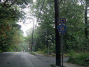
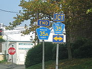
Route 35

Rockland County, New York
Rockland County is a suburban county 15 miles to the northwest of Manhattan and part of the New York City Metropolitan Area, in the U.S. state of New York. It is the southernmost county in New York west of the Hudson River, and the smallest county in New York outside of New York City. The...
.
Route 35 begins close to the New Jersey border at CR 30 in Pearl River, and ends at CR 60 in Nanuet. CR 35 runs through Pearl River, Chestnut Ridge, Spring Valley, and Nanuet. CR 35's southern terminus used to be a half-mile east of its current location. CR 35 followed the eastern portion of CR 30's route to NY 304
New York State Route 304
New York State Route 304 is a New York State Route that is entirely located in Central Rockland County. NY 304 begins at the New Jersey-New York border in Pearl River, New York, and ends at US 9W. Though it crosses both the New York State Thruway and the Palisades Interstate...
, but was replaced by an even numbered route because this stretch is east–west. The current portion of CR 30 west of CR 35 was not signed. After a long stretch through residential Chestnut Ridge, CR 35 enters a busy area in Spring Valley. Northbound Garden State Parkway
Garden State Parkway
The Garden State Parkway is a 172.4-mile limited-access toll parkway that stretches the length of New Jersey from the New York line at Montvale, New Jersey, to Cape May at New Jersey's southernmost tip. Its name refers to New Jersey's nickname, the "Garden State." Most New Jersey residents refer...
ends at the New York State Thruway
New York State Thruway
The New York State Thruway is a system of limited-access highways located within the state of New York in the United States. The system, known officially as the Governor Thomas E. Dewey Thruway for former New York Governor Thomas E. Dewey, is operated by the New York State Thruway Authority and...
, but has an alternate exit unto CR 35 for drivers heading into Spring Valley and Nanuet
Nanuet, New York
Nanuet is a hamlet , in the Town of Clarkstown Rockland County, New York, United States located north of Pearl River; south of New City; east of Spring Valley and west of West Nyack. It is 19 miles north of Manhattan, and 2 miles north of the New Jersey border...
. The GSP cannot be entered from CR 35, nor can southbound GSP drivers exit unto CR 35. CR 35 shares a terminus with CR 60 at the Smith Road/Pascack Road intersection. Pascack Road continues north for a bit before ending at CR 74
County Route 74 (Rockland County, New York)
County Route 74 is a long west–east county route in the central part of Rockland County, New York. CR 74 begins at US 202 in Montebello, near Harriman State Park, and ends at CR 35A in New City. CR 74 is an alternate route to County Route 80, as it runs...
.
CR 35 is part of the original routing of NY 304
New York State Route 304
New York State Route 304 is a New York State Route that is entirely located in Central Rockland County. NY 304 begins at the New Jersey-New York border in Pearl River, New York, and ends at US 9W. Though it crosses both the New York State Thruway and the Palisades Interstate...
.
CR 35 has three suffixed routes:
- CR 35A- The only child route that is longer than mere tenths of a mile.
- CR 35B- Route 35B was 0.1 mile (0.160934 km) route that began at CR 30 and ended at CR 35 along Old South Highland Avenue in Pearl River.
- CR 35C- Route 35C is a disputed 0.1 mile (0.160934 km) route that begins at CR 35 and ends at CR 35A along Perlman Drive. The reason CR 35C is disputed is because it is not signed, but in fact is still signed CR 35A. CR 35A used to run along Perlman Drive before being extended northward along West Clarkstown Road. County maps show Perlman Drive as CR 35C.
Route 35A

Rockland County, New York
Rockland County is a suburban county 15 miles to the northwest of Manhattan and part of the New York City Metropolitan Area, in the U.S. state of New York. It is the southernmost county in New York west of the Hudson River, and the smallest county in New York outside of New York City. The...
.
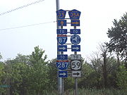
Route 35A begins at CR 35 in Spring Valley, and ends at CR 80 in New City. CR 35A runs through Spring Valley, Nanuet, and New City. CR 35A begins as a spur from CR 35 to NY 59 in a busy area of Spring Valley. This little spur has commuter lots on both sides. CR 35A then merges with NY 59, and shares an intersection with the northbound entrance/exit for Exit 14A of the New York State Thruway
New York State Thruway
The New York State Thruway is a system of limited-access highways located within the state of New York in the United States. The system, known officially as the Governor Thomas E. Dewey Thruway for former New York Governor Thomas E. Dewey, is operated by the New York State Thruway Authority and...
(I-87/I-287). At the next traffic light, CR 35A turns right, and proceeds north for the rest of its route. CR 35A is the longest child county route in Rockland County. Actually, CR 35A is the only child that is longer than one-tenth of a mile. Only as recently as the late 1990s was CR 35A extended south beyond NY 59 and north beyond the Spring Valley Market Place. In fact, CR 35A used to begin at NY 59, and turn left at Perlman Road at the first traffic light. CR 35A signs still remain on Perlman Road, which was formally the northern terminus of the route. County maps of Rockland County label this CR 35C even though CR 35A signs stand.
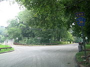
Route 36

Rockland County, New York
Rockland County is a suburban county 15 miles to the northwest of Manhattan and part of the New York City Metropolitan Area, in the U.S. state of New York. It is the southernmost county in New York west of the Hudson River, and the smallest county in New York outside of New York City. The...
.
Route 36 begins at CR 15, and ends at North Molson Road CR 36 runs exclusively through residential areas of Blauvelt. CR 36 eastern terminus is just 0.1 mile (0.160934 km) away from NY 303
New York State Route 303
New York State Route 303 is a north–south state highway in eastern Rockland County, New York, in the United States. It begins at the New Jersey state line in the hamlet of Tappan and ends later at an intersection with U.S. Route 9W in Clarkstown...
, but because the end of Leber Road is a one-way bridge it is not designated CR 36. Some Rockland County maps actually show CR 36 continuing over the bridge, crossing NY 303, and finally ending at CR 11 about a hundred feet later. However, a CR 36 end shield exists before the bridge. With Rockland County removing some of their routes in recent years, logic says CR 36 could be on the block. CR 36 is merely a side street serving a Blauvelt residential neighborhood, and it doesn't even have double yellow lines any more.
Route 37

Rockland County, New York
Rockland County is a suburban county 15 miles to the northwest of Manhattan and part of the New York City Metropolitan Area, in the U.S. state of New York. It is the southernmost county in New York west of the Hudson River, and the smallest county in New York outside of New York City. The...
. Known as South Central Avenue, the road was decommissioned and handed over to the town of Chestnut Ridge, New York
Chestnut Ridge, New York
Chestnut Ridge is a village in the Town of Ramapo Rockland County, New York, United States located north of the state of New Jersey; east of Monsey; south of Spring Valley and west of Nanuet. The population was 7,829 at the 2000 census....
.
Former Route 37 began at a curve with the Old Nyack Turnpike near the New York State Thruway
New York State Thruway
The New York State Thruway is a system of limited-access highways located within the state of New York in the United States. The system, known officially as the Governor Thomas E. Dewey Thruway for former New York Governor Thomas E. Dewey, is operated by the New York State Thruway Authority and...
. The road intersected with several local roads, some of which intersected other routes. CR 37 came to an end at NY 59.
Route 38


Rockland County, New York
Rockland County is a suburban county 15 miles to the northwest of Manhattan and part of the New York City Metropolitan Area, in the U.S. state of New York. It is the southernmost county in New York west of the Hudson River, and the smallest county in New York outside of New York City. The...
.
Route 38 begins at CR 11 in Blauvelt, and ends at the back entrance of Nyack College
Nyack College
Nyack College is a private, evangelical, liberal arts college affiliated with the Christian and Missionary Alliance and home to the Alliance Theological Seminary, one of the denomination's seminaries. The main campus is located in Nyack, New York...
. CR 38 runs through Blauvelt, along the northern border of Blauvelt State Park, and Nyack. CR 38's western terminus used to extend to NY 303
New York State Route 303
New York State Route 303 is a north–south state highway in eastern Rockland County, New York, in the United States. It begins at the New Jersey state line in the hamlet of Tappan and ends later at an intersection with U.S. Route 9W in Clarkstown...
, and only recently was shortened to begin at CR 11. In fact, Bradley Hill Road extends west beyond NY 303 for about a quarter-mile. After being truncated, CR 38 is one of the more hidden Rockland County routes.
See also
- List of county routes in Rockland County, New York
- List of county routes in Rockland County, New York (41–75)
- List of county routes in Rockland County, New York (76–118A)