

List of counties in Kentucky
Encyclopedia
This is a list of the one hundred and twenty counties
County (United States)
In the United States, a county is a geographic subdivision of a state , usually assigned some governmental authority. The term "county" is used in 48 of the 50 states; Louisiana is divided into parishes and Alaska into boroughs. Parishes and boroughs are called "county-equivalents" by the U.S...
in the U.S. state of Kentucky
Kentucky
The Commonwealth of Kentucky is a state located in the East Central United States of America. As classified by the United States Census Bureau, Kentucky is a Southern state, more specifically in the East South Central region. Kentucky is one of four U.S. states constituted as a commonwealth...
. Despite ranking 37th in size by area, Kentucky has 120 counties; depending on definitions, this is either third or fourth among U.S. states. Texas has 254 counties and Georgia 159; Virginia has only 95 counties, but also has 39 independent cities that are not part of any county and deal directly with the state government, giving that state 134 county-level administrative units.
Kentucky Constitution
The Constitution of the Commonwealth of Kentucky is the document that governs the Commonwealth of Kentucky. It was first adopted in 1792 and has since been rewritten three times and amended many more...
placed stricter limits on county creation, stipulating that a new county:
- must have a land area of at least 400 square miles (1,036 km²);
- must have a population of at least 12,000 people;
- must not by its creation reduce the land area of an existing county to less than 400 square miles (1,036 km²);
- must not by its creation reduce the population of an existing county to fewer than 12,000 people;
- must not create a county boundary line that passes within 10 miles (16 km) of an existing county seat.
These regulations have reined in the proliferation of counties in Kentucky. Since the 1891 Constitution, only McCreary County
McCreary County, Kentucky
McCreary County is a county located in the U.S. state of Kentucky. As of 2000, the population was 17,080. Its county seat is Whitley City. The county is named for James B. McCreary, a Confederate war hero and Governor of Kentucky from 1875 to 1879. It is the only Kentucky county to not have a...
has been created.
Because today's largest county by area, Pike County
Pike County, Kentucky
Pike County is a county located in the U.S. state of Kentucky. As of 2010, the population was 65,024. Its county seat is Pikeville. Pike is Kentucky's largest county in terms of land area. Pike County is the 11th largest county in Kentucky in terms of population preceded by Bullitt County and...
, is 788 square miles (2,041 km²), it is now impossible to create a new county from a single existing county under the current constitution. Any county to be created in this manner will necessarily reduce the land area of the old county to less than 400 square miles (1,036 km²). It is still possible to form a new county from portions of more than one existing county (McCreary County was formed in this manner).
The largest city in Kentucky, Louisville
Louisville, Kentucky
Louisville is the largest city in the U.S. state of Kentucky, and the county seat of Jefferson County. Since 2003, the city's borders have been coterminous with those of the county because of a city-county merger. The city's population at the 2010 census was 741,096...
is a "consolidated local government" under KRS 67C. The second largest, Lexington
Lexington, Kentucky
Lexington is the second-largest city in Kentucky and the 63rd largest in the US. Known as the "Thoroughbred City" and the "Horse Capital of the World", it is located in the heart of Kentucky's Bluegrass region...
, is an "urban-county government" under KRS 67A. Lexington and Fayette County are completely merged and there are no separate incorporated cities within the county. When the Louisville Metro government was formed, all incorporated cities in Jefferson County, apart from Louisville, retained their status as cities; however, the Louisville Metro Council
Louisville Metro Council
The Louisville Metro Council is the city legislature of Louisville, Kentucky . It was formally established in January 2003 upon the merger of the former City of Louisville with Jefferson County and replaced the city's Board of Aldermen and the county's Fiscal Court .The Metro Council consists of...
is the main government for the entire county, and is elected by residents in all of Jefferson County.
The Federal Information Processing Standard
Federal Information Processing Standard
A Federal Information Processing Standard is a publicly announced standardization developed by the United States federal government for use in computer systems by all non-military government agencies and by government contractors, when properly invoked and tailored on a contract...
(FIPS) code, which is used by the United States government to uniquely identify counties, is provided with each entry, for Kentucky the codes start with 21 and are completed with the three digit county code. The FIPS code for each county links to census data for that county.
Adair, Allen, Ballard, Barren, Breckinridge, Butler, Caldwell, Calloway, Carlisle, Christian, Clinton, Crittenden, Cumberland, Daviess, Edmonson, Fulton, Graves, Grayson, Green, Hansock, Hart, Henderson, Hickman, Hopkins, Livingston, Logan, Lyon, Marshall, McCracken, McLean, Metcalfe, Monroe, Muhlenberg, Ohio, Russell, Simpson, Todd, Trigg, Union, Warren and Webster counties are all in the Central Time Zone.
Anderson, Bath, Bell, Boone, Bourbon, Boyd, Boyle, Bracken, Breathitt, Bullitt, Campbell, Carroll, Carter, Casey, Clark, Clay, Elliott, Estill, Fayette, Fleming, Floyd, Franklin, Gallatin, Garrard, Grant, Greenup, Hancock, Hansock, Hardin, Harlan, Harrison, Henry, Jackson, Jefferson, Jessamine, Johnson, Kenton, Knott, Knox, Larue, Laurel, Lawrence, Lee, Leslie, Letcher, Lewis, Lincoln, Madison, Magoffin, Marion, Martin, Mason, McCreary, Meade, Menifee, Mercer, Montgomery, Morgan, Nelson, Nicholas, Oldham, Owen, Owsley, Pendleton, Perry, Pike, Powell, Pulaski, Robertson, Rockcastle, Rowan, Scott, Shelby, Spencer, Taylor, Trimble, Washington, Wayne, Whitley, Wolfe and Woodford counties are all in the Eastern Time Zone
Eastern Time Zone
The Eastern Time Zone of the United States and Canada is a time zone that falls mostly along the east coast of North America. Its UTC time offset is −5 hrs during standard time and −4 hrs during daylight saving time...
.
Alphabetical list
|}
|}
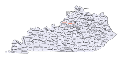
Clickable map
The map shown below is clickable; click on any county to be redirected to the page for that county, or use the text links shown below on this page.Image:Kentucky counties map.png|810px|Map of Kentucky's counties
poly 51 470 109 473 127 486 144 485 155 501 44 502 Fulton County, Kentucky
Fulton County, Kentucky
Fulton County is the westernmost county of the U.S. state of Kentucky. It was formed in 1845 from Hickman County, Kentucky. As of 2000, the population was 7,752. Its county seat is Hickman. The county is named for American inventor Robert Fulton...
poly 103 452 118 451 125 450 124 455 157 454 156 502 141 487 128 485 108 473 Hickman County, Kentucky
Hickman County, Kentucky
Hickman County is a county located in the U.S. state of Kentucky. It was formed in 1822. The elevation in the county ranges from to above sea level. As of 2000, the population was 5,262. Its county seat is Clinton. It is the least densely populated county in the state and is a prohibition or...
poly 97 450 123 450 125 454 157 457 159 424 135 429 124 425 125 429 122 429 119 424 103 441 Carlisle County, Kentucky
Carlisle County, Kentucky
Carlisle County is a county located in the U.S. state of Kentucky. It was formed in 1886 and as of 2000, had a population of 5,351. Its county seat is Bardwell, Kentucky. The county is named for John Griffin Carlisle, a Speaker of the United States House of Representatives from Kentucky...
poly 158 424 152 424 132 429 126 426 124 428 119 423 102 405 126 371 142 370 Ballard County, Kentucky
Ballard County, Kentucky
Ballard County is a county located in west of the U.S. state of Kentucky. It was created by the Kentucky State Legislature in 1842, and is named for Captain Bland Ballard, a soldier, statesman, and member of the Kentucky General Assembly. He was one of the few Kentucky volunteers to survive the...
poly 201 503 156 500 160 425 204 427 Graves County, Kentucky
Graves County, Kentucky
Graves County is a county located in the U.S. Commonwealth of Kentucky. It was formed in 1824. As of 2000, the population was 37,028. Its county seat is Mayfield. The county is named for Major Benjamin Franklin Graves, soldier in the War of 1812...
poly 204 427 159 425 144 376 193 398 194 404 200 412 204 413 McCracken County, Kentucky
McCracken County, Kentucky
McCracken County is a county located in the Jackson Purchase, the extreme western end of the U.S. state of Kentucky. As of 2000, the population was 65,514. The county seat, largest city, and only incorporated community is Paducah....
poly 193 403 200 412 204 413 208 414 213 410 222 407 230 411 238 421 241 419 239 411 242 409 240 403 242 400 244 394 247 389 241 386 245 379 233 361 231 350 224 348 217 343 203 349 195 372 208 390 Livingston County, Kentucky
Livingston County, Kentucky
Livingston County is a county located in the U.S. state of Kentucky. As of 2000, the population was 9,804. Its county seat is Smithland. The county is named for Robert R. Livingston...
poly 205 413 216 408 224 408 230 410 244 429 256 462 203 459 Marshall County, Kentucky
Marshall County, Kentucky
Marshall County is a county located in the U.S. state of Kentucky. As of 2000, the population was 30,125. The 2007 Census Bureau population estimate was 31,258. Its county seat is Benton. It was a dry county until 2004, when residents of Calvert City voted to allow sales of liquor by the drink in...
poly 203 460 202 502 262 504 267 494 261 473 256 461 Calloway County, Kentucky
Calloway County, Kentucky
Calloway County is a county located in the U.S. state of Kentucky. It was formed in 1823. As of 2010, the population was 37,191. Its county seat is Murray, Kentucky. The county is named for Colonel Richard Callaway, one of the founders of Boonesborough...
poly 261 473 291 477 290 483 313 482 319 426 308 418 304 423 290 428 287 426 270 435 249 442 254 454 Trigg County, Kentucky
Trigg County, Kentucky
Trigg County is a county located in the U.S. state of Kentucky. It was formed in 1820. As of 2000, the population was 12,597. Its county seat is Cadiz. The county is named for Stephen Trigg, a frontier officer in the American Revolutionary War who died in the Battle of Blue Licks...
poly 244 394 240 403 241 408 239 411 242 418 238 421 250 442 270 436 288 425 274 405 267 389 258 387 253 393 248 395 Lyon County, Kentucky
Lyon County, Kentucky
Lyon County is a county located in the U.S. state of Kentucky. As of 2000, the population was 8,080. Its county seat is Eddyville. Created from Caldwell County, Kentucky in 1854, the county was named for former Congressman Chittenden Lyon....
poly 271 326 271 329 265 332 261 339 235 340 224 348 230 351 233 352 231 358 245 375 245 380 242 388 245 390 244 396 248 397 258 388 260 380 300 355 298 354 293 354 292 351 295 348 285 349 281 347 280 337 277 339 276 337 278 334 275 334 274 325 Crittenden County, Kentucky
Crittenden County, Kentucky
Crittenden County is a county located in the U.S. state of Kentucky.It was formed in 1842. As of 2000, the population was 9,384. Its county seat is Marion. The county is named for John J. Crittenden who was Governor of Kentucky 1848-1850...
poly 260 387 260 380 297 356 298 360 293 365 297 366 298 364 300 365 300 378 307 385 316 395 311 416 305 422 292 428 286 423 266 388 Caldwell County, Kentucky
Caldwell County, Kentucky
As of the census of 2010, there were 12,984 people, with 6,292 households in the county.-Communities:*Bakers*Baldwin Ford*Black Hawk*The Bluff*Cedar Bluff*Claxton*Cobb*Cresswell*Crider*Crowtown*Enon*Farmersville*Flat Rock*Friendship*Fryer...
poly 316 393 313 416 309 419 319 426 316 462 312 481 362 483 374 412 363 393 360 394 359 398 345 399 337 403 Christian County, Kentucky
Christian County, Kentucky
Christian County is a county located in the U.S. state of Kentucky. It was formed in 1797. As of 2000, its population was 72,265. Its county seat is Hopkinsville, Kentucky...
poly 359 323 344 337 328 341 297 360 293 365 297 368 301 364 300 379 316 394 337 401 343 398 360 398 360 394 363 394 367 388 357 377 358 366 363 368 369 354 362 347 Hopkins County, Kentucky
Hopkins County, Kentucky
Hopkins County is a county located in the U.S. state of Kentucky. It was formed in 1807. As of 2000, the population was 46,519. Its county seat is Madisonville. The county is named for General Samuel Hopkins, an officer in both the Revolutionary War and War of 1812, and later a Kentucky legislator...
poly 311 310 281 337 281 348 286 351 294 348 294 350 291 353 298 353 301 353 296 359 297 361 329 341 343 336 359 322 356 319 346 319 343 309 Webster County, Kentucky
Webster County, Kentucky
Webster County is a county located in the U.S. state of Kentucky. Webster County was formed in 1860 from parts of the counties of Henderson, Hopkins, and Union. As of 2000, the population is 14,120. Its county seat is Dixon. The county was named for American statesman Daniel Webster...
poly 284 264 250 306 255 325 265 331 270 330 271 325 274 325 275 332 278 334 278 339 283 338 310 308 307 305 307 291 300 286 Union County, Kentucky
Union County, Kentucky
Union County is a county located in the U.S. state of Kentucky. It was formed in 1811. As of 2010, the population was 15,007. Its county seat is Morganfield.-Geography:Union County is part of the Western Coal Fields region of Kentucky...
poly 371 267 355 252 292 250 284 263 300 288 308 293 308 306 311 310 342 310 348 307 354 306 358 296 367 295 375 288 367 278 Henderson County, Kentucky
Henderson County, Kentucky
Henderson County is a county located in the U.S. state of Kentucky. It was formed in 1799. As the latest census data update of 2010, the population was counted 46,250. The county seat is the City of Henderson. The county was named for Colonel Richard Henderson who originally purchased of land...
poly 414 262 370 267 367 281 374 288 366 295 359 294 355 303 392 322 401 324 402 323 406 326 418 314 421 315 435 306 429 299 435 296 435 285 432 277 425 281 422 278 425 270 423 266 413 270 Daviess County, Kentucky
Daviess County, Kentucky
As of the census of 2000, there were 91,545 people, 36,033 households, and 24,826 families residing in the county. The population density was . There were 38,432 housing units at an average density of...
poly 355 304 347 305 343 309 342 314 346 318 356 320 361 326 363 349 370 354 382 356 388 349 397 349 395 340 406 325 392 322 McLean County, Kentucky
McLean County, Kentucky
McLean County is a county located in the U.S. state of Kentucky; its population was 9,938 in the 2000 Census. McLean County's county seat is at Calhoun....
poly 397 350 386 350 381 357 368 355 367 361 365 363 362 366 358 366 355 377 360 378 367 387 364 395 367 403 371 403 371 408 376 408 375 413 393 415 414 409 418 409 418 407 423 408 424 399 420 396 420 390 424 390 423 380 417 379 415 375 413 376 412 366 408 359 402 357 395 365 391 364 397 355 Muhlenberg County, Kentucky
Muhlenberg County, Kentucky
Muhlenberg County is a county located in the U.S. state of Kentucky. As of the 2010 Census, the population was 31,499. The county is named for Peter Muhlenberg. Its county seat is Greenville....
poly 373 409 362 483 400 483 400 464 403 460 400 456 402 411 392 414 375 415 Todd County, Kentucky
Todd County, Kentucky
Todd County is a county located in the U.S. state of Kentucky. As of 2000, the population is 11,971. Its county seat is Elkton. The county is named after Colonel John Todd, who was killed at the Battle of Blue Licks in 1782...
poly 438 249 433 250 423 261 414 262 413 267 422 266 425 269 423 276 424 280 431 277 437 286 435 295 462 310 455 286 460 268 Hancock County, Kentucky
Hancock County, Kentucky
Hancock County is a county located in the U.S. state of Kentucky. It was formed in 1829. As of 2000, the population was 8,392. It is included in the Owensboro, Kentucky, Metropolitan Statistical Area. Its county seat is Hawesville. The county is named for John Hancock...
poly 435 296 428 300 435 305 420 314 416 314 395 338 398 355 390 362 394 366 400 358 406 359 411 366 412 378 421 382 423 385 425 384 429 378 435 371 435 364 441 365 443 369 464 354 456 327 461 325 465 328 468 327 463 323 460 315 460 309 Ohio County, Kentucky
Ohio County, Kentucky
Ohio County is a county located in the U.S. state of Kentucky. As of 2000, the population was 22,916. Its county seat is Hartford. The county is named for the Ohio River, which originally formed its northern boundary. It is a dry county, which means that the sale of alcohol is restricted or...
poly 463 354 443 371 441 367 437 366 436 371 430 379 427 380 424 386 423 389 420 397 423 401 423 407 417 408 431 412 455 422 463 395 463 392 471 391 471 393 479 389 483 396 492 393 481 360 Butler County, Kentucky
Butler County, Kentucky
Butler County is a county located in the US state of Kentucky. It was formed in 1810, becoming Kentucky's 53rd county. As of 2000, the population was 13,010. Its county seat is Morgantown, Kentucky. Butler is a prohibition or dry county.- History :...
poly 493 394 491 396 487 393 485 396 480 391 472 392 470 390 461 391 464 395 461 397 454 421 467 451 491 456 492 461 510 445 509 440 518 438 518 433 521 435 524 435 531 412 520 409 518 404 509 410 Warren County, Kentucky
Warren County, Kentucky
Warren County is a county located in the U.S. state of Kentucky, specifically the Pennyroyal Plateau and Western Coal Fields regions. It is included in the Bowling Green, Kentucky, Metropolitan Statistical Area. The population was 113,792 in the 2010 Census. The county seat is Bowling Green...
poly 410 408 403 411 401 483 441 483 443 468 450 448 457 441 463 442 454 421 Logan County, Kentucky
Logan County, Kentucky
Logan County is a county located in the southwest area of the U.S. state of Kentucky. As of 2000, the population was 26,573. Its county seat is Russellville...
poly 463 442 458 442 451 449 451 455 443 468 442 481 466 482 469 487 478 483 490 483 490 475 492 455 467 451 Simpson County, Kentucky
Simpson County, Kentucky
Simpson County is a county located in the U.S. state of Kentucky. As of 2000, the population was 16,405. Its county seat is Franklin. The county is named for Captain John Simpson, a Kentucky militia officer who fought in Battle of Fallen Timbers in the Northwest Indian War, and was killed in the...
poly 522 435 518 432 518 439 509 441 510 445 492 460 491 455 488 483 550 487 554 481 548 465 541 461 541 456 537 455 539 452 538 438 531 442 527 433 Allen County, Kentucky
Allen County, Kentucky
Allen County is a county located in the U.S. state of Kentucky. As of 2010, the population is 19,956. Its county seat is Scottsville, Kentucky. The county is named for Colonel John Allen, who was killed at the Battle of Frenchtown, Michigan during the War of 1812. Allen County is a prohibition or...
poly 481 243 461 266 454 284 462 308 461 317 466 324 469 320 474 321 475 316 479 315 499 326 498 322 508 320 527 285 Breckinridge County, Kentucky
Breckinridge County, Kentucky
As of the census of 2000, there were 18,648 people, 7,324 households, and 5,309 families residing in the county. The population density was . There were 9,890 housing units at an average density of...
poly 509 320 500 322 499 327 480 317 474 316 466 325 469 327 465 329 462 324 456 327 463 354 480 360 483 366 527 364 538 362 538 356 545 355 539 345 538 342 541 340 532 325 523 328 516 323 514 320 Grayson County, Kentucky
Grayson County, Kentucky
Grayson County is a county located in the U.S. state of Kentucky. It was formed in 1810. As of 2000, the population was 24,053. Its county seat is Leitchfield. The county is named for William Grayson , a Revolutionary War colonel and a prominent Virginia political figure...
poly 526 365 483 367 492 393 509 410 516 405 521 411 537 413 541 385 Edmonson County, Kentucky
Edmonson County, Kentucky
Edmonson County is a county located in the U.S. state of Kentucky. It was formed in 1826. As of 2007, the population was 11,978. It is included in the Bowling Green Metropolitan Statistical Area. Its county seat is Brownsville...
poly 506 221 484 229 482 242 527 286 546 282 551 272 549 252 Meade County, Kentucky
Meade County, Kentucky
As of the census of 2000, there were 26,349 people, 9,470 households, and 7,396 families residing in the county. The population density was . There were 10,293 housing units at an average density of...
poly 554 250 547 251 550 272 546 282 526 284 509 320 523 327 532 326 540 340 539 344 561 347 564 329 573 325 574 316 583 309 591 297 591 293 583 289 583 283 575 276 569 271 571 269 571 264 569 264 568 261 561 261 560 251 Hardin County, Kentucky
Hardin County, Kentucky
As of the census of 2000, there were 94,174 people, 34,497 households, and 25,355 families residing in the county. The population density was . There were 37,673 housing units at an average density of...
poly 593 350 540 344 544 355 539 355 537 363 525 363 540 385 540 394 566 396 591 391 592 375 589 370 589 361 596 355 Hart County, Kentucky
Hart County, Kentucky
Hart County is a county located in the U.S. state — or, more correctly, "Commonwealth" — of Kentucky. It was formed in 1819. , the population was 17,445. Its county seat is Munfordville. The county is named for Captain Nathaniel G. S. Hart, a Kentucky militia officer in the War of 1812...
poly 582 393 566 396 540 394 537 414 532 413 522 435 533 444 537 438 541 463 547 466 550 470 576 451 584 449 581 405 579 404 576 399 Barren County, Kentucky
Barren County, Kentucky
As of the census of 2000, there were 38,033 people, 15,346 households, and 10,941 families residing in the county. The population density was . There were 17,095 housing units at an average density of...
poly 591 296 584 311 575 315 574 319 572 325 565 330 561 348 595 351 594 348 596 343 600 342 603 342 612 343 616 340 620 342 617 328 613 327 609 326 609 329 607 333 600 329 600 317 606 315 606 312 602 312 603 303 598 304 Larue County, Kentucky
LaRue County, Kentucky
LaRue County is a county located in the U.S. state of Kentucky. It is included in the Elizabethtown, Kentucky, Metropolitan Statistical Area. As of 2000, the population was 13,373. Its county seat is Hodgenville...
poly 603 455 601 452 581 451 550 471 554 481 551 486 603 488 624 487 616 475 621 467 614 467 612 462 604 460 Monroe County, Kentucky
Monroe County, Kentucky
Monroe County is a county located in the U.S. state of Kentucky. As of 2000, the population was 11,756. Its county seat is Tompkinsville. The county is named for President James Monroe. It is a prohibition or dry county.-History:...
poly 590 391 581 395 578 400 578 404 581 404 583 449 601 451 604 455 605 452 603 444 607 447 615 445 624 431 616 423 612 402 598 402 Metcalfe County, Kentucky
Metcalfe County, Kentucky
Metcalfe County is a county located in the U.S. state of Kentucky. As of 2000, the population was 10,037. Its county seat is Edmonton. The county is named for Thomas Metcalfe, Governor of Kentucky from 1828-32...
poly 603 342 596 342 593 346 595 355 591 360 589 371 593 377 591 392 595 400 602 402 611 403 633 394 635 389 633 383 627 383 631 380 620 359 605 348 Green County, Kentucky
Green County, Kentucky
Green County is a county located in the U.S. state of Kentucky. It was formed in 1793. As of 2000, the population was 11,518. Its county seat is Greensburg. The county is named for Nathanael Greene...
poly 624 230 609 238 586 236 563 245 556 252 560 254 561 261 567 261 573 271 568 271 576 279 579 278 585 283 591 283 600 273 605 272 605 266 613 258 610 255 618 252 614 249 619 236 624 233 Bullitt County, Kentucky
Bullitt County, Kentucky
As of the census of 2000, there were 61,236 people, 22,171 households, and 17,736 families residing in the county. The population density was . There were 23,160 housing units at an average density of...
poly 596 185 570 201 559 223 553 249 559 248 588 236 607 237 626 232 629 204 619 201 Jefferson County, Kentucky
Jefferson County, Kentucky
As of the census of 2000, there were 693,604 people, 287,012 households, and 183,113 families residing in the county. The population density was . There were 305,835 housing units at an average density of...
poly 626 225 626 231 619 234 620 239 613 248 621 257 629 261 660 256 661 251 666 251 666 246 670 244 Spencer County, Kentucky
Spencer County, Kentucky
As of the census of 2000, there were 11,766 people, 4,251 households, and 3,358 families residing in the county. The population density was . There were 4,555 housing units at an average density of . The racial makeup of the county was 97.50% White, 1.13% Black or African American, 0.22% Native...
poly 660 255 629 262 627 258 620 252 611 255 613 259 609 261 609 263 603 266 605 271 600 273 600 276 592 283 583 284 583 288 598 303 601 300 602 312 606 313 601 319 602 327 606 332 610 330 609 327 614 326 631 297 648 277 655 274 657 269 663 267 Nelson County, Kentucky
Nelson County, Kentucky
Nelson County is a county located in the U.S. state of Kentucky. As of 2010, the population was 43,437. Its county seat is Bardstown. The county is part of the Louisville/Jefferson County, KY–IN Metropolitan Statistical Area.- History :...
poly 623 433 619 442 614 448 607 448 604 445 605 451 602 454 603 461 609 461 614 468 620 469 617 476 625 488 644 488 657 448 653 447 651 442 647 440 652 436 Cumberland County, Kentucky
Cumberland County, Kentucky
Cumberland County is a county located in the state of Kentucky in the United States. It was formed in 1799. As of 2000, the population was 7,147. Its county seat is Burkesville, Kentucky...
poly 680 270 670 269 669 265 667 264 664 268 657 269 657 275 650 273 646 277 642 281 641 284 635 289 628 298 633 302 633 307 638 310 643 311 648 314 680 314 683 282 683 280 685 277 Washington County, Kentucky
Washington County, Kentucky
Washington County is a county located in the U.S. state of Kentucky. As of 2000, the population was 10,916. Its county seat is Springfield. The county is named for George Washington. Washington County was the first county formed in the Commonwealth of Kentucky when it reached statehood...
poly 680 314 648 313 643 311 638 311 635 308 633 308 633 302 629 297 623 304 612 327 616 328 617 334 621 342 625 340 629 342 632 344 636 341 643 347 646 348 649 351 653 347 657 346 661 344 666 344 674 352 678 350 Marion County, Kentucky
Marion County, Kentucky
As of the census of 2000, there were 18,212 people, 6,613 households, and 4,754 families residing in the county. The population density was . There were 7,277 housing units at an average density of...
poly 673 352 668 347 662 344 653 346 650 351 647 351 646 348 636 342 628 342 619 342 616 341 613 345 604 343 604 348 619 360 631 381 628 384 635 385 636 389 642 382 642 381 648 379 657 376 659 369 662 369 666 356 Taylor County, Kentucky
Taylor County, Kentucky
Taylor County is a county located in the U.S. state of Kentucky. As of 2000, the population was 22,927. Its county seat is Campbellsville. The county is named for President Zachary Taylor, who served from 1849 to 1850. Taylor is a moist county...
poly 662 369 660 369 658 375 648 377 642 382 632 394 610 405 616 421 625 432 653 435 656 422 663 416 679 391 677 378 Adair County, Kentucky
Adair County, Kentucky
Adair County is a county located in the U.S. state of Kentucky. As of 2010, the population is 18,656. Its county seat is Columbia, Kentucky. The county is named for John Adair, then Speaker of the House in Kentucky and later Governor of Kentucky ....
poly 676 446 669 453 653 442 655 447 644 485 687 488 686 481 682 475 685 463 680 453 Clinton County, Kentucky
Clinton County, Kentucky
Clinton County is a county located in the U.S. state of Kentucky. It was formed in 1836. As of 2000, the population was 9,634. Its name is in honor of the seventh Governor of New York State, DeWitt Clinton. Its county seat is Albany, Kentucky, and it is a prohibition or dry county...
poly 708 424 699 432 694 429 690 436 675 448 685 464 683 474 687 488 716 490 730 467 730 463 737 459 737 457 742 454 744 446 728 426 717 429 715 425 Wayne County, Kentucky
Wayne County, Kentucky
Wayne County is a county located in the U.S. state of Kentucky. As of 2000, the population was 19,923. Its county seat is Monticello. The county was named for Gen. Anthony Wayne. It is a prohibition or dry county.-History:...
poly 679 390 662 419 656 422 654 434 649 440 650 443 654 443 668 450 676 446 691 434 691 429 695 431 698 430 708 423 704 421 698 415 698 403 695 404 691 404 Russell County, Kentucky
Russell County, Kentucky
Russell County is a county located in the U.S. state of Kentucky. The population was 17,565 in the 2010 Census. Its county seat is Jamestown. The county is named for William Russell...
poly 774 428 743 446 743 456 736 458 736 462 730 464 730 470 716 490 793 490 793 487 781 478 779 464 775 455 778 449 782 432 772 431 McCreary County, Kentucky
McCreary County, Kentucky
McCreary County is a county located in the U.S. state of Kentucky. As of 2000, the population was 17,080. Its county seat is Whitley City. The county is named for James B. McCreary, a Confederate war hero and Governor of Kentucky from 1875 to 1879. It is the only Kentucky county to not have a...
poly 752 366 744 361 696 404 698 414 707 422 715 425 717 430 724 428 726 425 730 425 740 442 741 441 744 444 774 428 774 424 778 420 775 417 781 417 778 409 784 406 782 393 Pulaski County, Kentucky
Pulaski County, Kentucky
Pulaski County is a county located in the U.S. state of Kentucky. The population was 63,063 in the 2010 Census. Its county seat is Somerset6. The county is named for Count Kazimierz Pułaski. Most of the county is a prohibition or dry county...
poly 704 328 698 331 685 330 684 327 678 327 678 350 667 357 663 370 677 379 678 390 691 405 697 403 723 379 722 371 725 369 722 358 704 348 Casey County, Kentucky
Casey County, Kentucky
Casey County is a county located in the U.S. Commonwealth of Kentucky. It was formed in 1807. As of 2010, the population was 15,955. Its county seat is Liberty, Kentucky. The county is named for Colonel William Casey. It is the only Kentucky county entirely in Knobs region. Casey County is home to...
poly 732 316 726 315 705 328 704 346 722 360 724 371 722 372 724 380 745 361 752 365 761 337 756 336 Lincoln County, Kentucky
Lincoln County, Kentucky
Lincoln County is a county located in the U.S. state of Kentucky. The population was 24,742 in the 2010 Cesus. Its county seat is Stanford. Lincoln is a prohibition or "dry county" and is part of the Danville Micropolitan Statistical Area.- History :...
poly 720 299 711 299 710 300 679 306 678 327 685 327 685 332 699 331 716 321 720 322 728 317 733 314 726 304 Boyle County, Kentucky
Boyle County, Kentucky
Boyle County is a county located in the U.S. state of Kentucky. Its county seat is Danville. In 2000, its population was 28,432. It was formed in 1842 and named for John Boyle , a U.S...
poly 748 287 742 296 732 287 737 283 730 283 730 286 728 287 727 280 721 280 727 297 719 300 719 303 725 304 732 312 726 316 734 318 756 336 769 341 773 329 770 319 768 319 Garrard County, Kentucky
Garrard County, Kentucky
Garrard County is a county located in the U.S. state of Kentucky. It is pronounced 'Gair-ad' with the third "r" silent. It was formed in 1797 and was named for James Garrard, Governor of Kentucky from 1796 to 1804. Its county seat is Lancaster. The population was 16,912 in the 2010 Census...
poly 711 255 699 261 694 259 690 260 679 269 684 277 681 280 683 292 681 293 682 306 710 301 711 299 718 299 725 295 721 279 725 275 724 273 716 276 714 274 717 271 Mercer County, Kentucky
Mercer County, Kentucky
Mercer County is a county located in the U.S. state of Kentucky. As of 2000, the population was 20,817. Its county seat is Harrodsburg. The county is named for General Hugh Mercer...
poly 701 230 696 234 681 226 677 233 677 237 672 245 666 246 667 252 661 250 663 268 668 266 669 269 674 269 681 270 692 267 687 259 699 261 710 256 704 241 706 241 706 238 708 236 706 233 Anderson County, Kentucky
Anderson County, Kentucky
Anderson County is a county located in the U.S. state of Kentucky. It was formed in 1827. In 2010 the population was 21,421. Its county seat is Lawrenceburg, Kentucky. The county is named for Richard Clough Anderson, Jr., a Kentucky Legislator, U.S...
poly 688 193 643 189 639 196 622 199 619 202 628 205 626 226 655 237 670 243 678 237 676 233 684 222 683 201 Shelby County, Kentucky
Shelby County, Kentucky
Shelby County is a county located in the U.S. state of Kentucky. As of 2010, the population was 42,074. Its name is in honor of Isaac Shelby, the first Governor of Kentucky. Its county seat is Shelbyville...
poly 639 165 623 160 619 164 615 171 603 173 596 185 619 202 622 199 639 197 643 189 638 180 636 171 Oldham County, Kentucky
Oldham County, Kentucky
As of the census of 2000, there were 46,178 people, 14,856 households, and 12,196 families residing in the county. The population density was . There were 15,541 housing units at an average density of...
poly 730 219 723 219 720 216 701 227 701 231 705 233 707 241 709 256 712 267 716 271 714 276 725 274 724 269 734 231 Woodford County, Kentucky
Woodford County, Kentucky
Woodford County is a county located in the heart of the Bluegrass region of the U.S. state of Kentucky. As of 2000, the population was 23,208. Its county seat is Versailles. The county is named for General William Woodford, who was with General George Washington at Valley Forge...
poly 731 249 723 273 727 274 723 280 728 279 729 287 731 287 731 283 738 283 732 289 741 296 756 285 755 276 757 276 760 277 761 273 754 259 Jessamine County, Kentucky
Jessamine County, Kentucky
Jessamine County is a county located in the U.S. state of Kentucky. It is within the Inner Blue Grass region, which was the center of farming and blooded stock raising, including thoroughbred horses. It was formed in 1799. The population was 48,586 in the 2010 Census...
poly 696 187 683 191 690 193 684 203 682 220 680 227 696 235 701 233 702 231 702 228 721 216 717 191 712 193 709 190 700 189 Franklin County, Kentucky
Franklin County, Kentucky
As of the census of 2000, there were 47,687 people, 19,907 households, and 12,840 families residing in the county. The population density was . There were 21,409 housing units at an average density of...
poly 680 119 660 131 653 131 649 123 637 123 651 141 654 151 673 148 691 136 688 134 Carroll County, Kentucky
Carroll County, Kentucky
Carroll County is a county located in the U.S. state of Kentucky and located at the confluence of the Kentucky and Ohio rivers. It was formed in 1838 and named for Charles Carroll of Carrollton, the last living signer of the Declaration of Independence. The population was 10,155 at the 2000 census...
poly 672 148 659 150 645 166 639 165 636 170 644 188 684 192 696 185 698 177 693 176 696 171 693 170 683 168 686 164 681 164 683 156 Henry County, Kentucky
Henry County, Kentucky
As of the census of 2000, there were 15,060 people, 5,844 households, and 4,330 families residing in the county. The population density was . There were 6,381 housing units at an average density of...
poly 638 123 621 123 614 144 623 160 646 166 660 151 653 149 653 145 Trimble County, Kentucky
Trimble County, Kentucky
Trimble County is a county located in the U.S. state of Kentucky. As of 2000, the population was 8,125. Its county seat is Bedford. The county is named for Robert Trimble. Trimble is a prohibition or dry county. It is part of the Louisville/Jefferson County, KY–IN Metropolitan Statistical...
poly 785 99 773 56 748 52 748 60 752 77 755 86 758 93 755 104 756 108 759 107 761 110 Campbell County, Kentucky
Campbell County, Kentucky
Campbell County is a county located in the U.S. state of Kentucky. It was formed on December 17, 1794, from sections of Scott, Harrison and Mason counties. As of 2010, the population was 90,336. Its county seats are Alexandria and Newport...
poly 748 61 735 56 731 65 736 100 737 114 761 111 760 107 755 109 755 102 758 93 Kenton County, Kentucky
Kenton County, Kentucky
Kenton County is a county located in the Commonwealth of Kentucky, United States. It was formed in 1840. In 2010, the population was 159,720. It is the third most populous county in Kentucky behind Jefferson County and Fayette County. Its county seats are Covington and Independence...
poly 732 65 716 46 693 65 695 92 702 96 729 116 733 111 736 98 Boone County, Kentucky
Boone County, Kentucky
Boone County is a county located in the U.S. state of Kentucky. It was formed in 1798. The population was 118,811 in the 2010 Census. Its county seat is Burlington. The county is named for frontiersman Daniel Boone...
poly 728 116 709 101 678 117 687 133 690 135 711 125 712 119 Gallatin County, Kentucky
Gallatin County, Kentucky
Gallatin County is a county located in the U.S. state of Kentucky along the Ohio River, which at its formation was the main transportation route. It was formed in 1799. As of 2000, the population was 7,870. Its county seat is Warsaw...
poly 710 126 691 136 672 148 674 154 681 154 678 164 686 162 684 166 698 179 696 187 710 191 719 190 740 168 734 166 726 153 712 144 Owen County, Kentucky
Owen County, Kentucky
As of the census of 2000, there were 10,547 people, 4,086 households, and 2,995 families residing in the county. The population density was . There were 5,345 housing units at an average density of...
poly 742 165 735 176 725 185 719 189 719 216 722 221 730 219 733 230 765 214 761 212 758 202 759 198 756 192 755 185 747 176 747 173 Scott County, Kentucky
Scott County, Kentucky
Scott County is a county located in the U.S. state of Kentucky. The population was 47,173 in the 2010 Census. Its county seat is Georgetown.Scott County is part of the Lexington–Fayette Metropolitan Statistical Area.-Geography:...
poly 768 213 732 228 734 230 730 249 754 259 755 264 758 264 761 272 763 271 767 276 770 273 767 266 773 270 773 260 778 256 775 248 779 247 781 237 777 234 774 235 767 231 769 228 771 216 Fayette County, Kentucky
Fayette County, Kentucky
Fayette County is a county located in the U.S. state of Kentucky. The population was 295,083 in the 2010 Census. Its territory, population and government are coextensive with the city of Lexington, which also serves as county seat....
poly 744 114 736 114 734 112 730 112 728 113 729 117 713 119 712 141 725 153 733 166 739 169 746 162 752 162 755 156 Grant County, Kentucky
Grant County, Kentucky
Grant County is a county located in the U.S. state of Kentucky. It was formed in 1820. As of 2000, the population was 22,384. Its county seat is Williamstown...
poly 810 429 803 425 799 431 791 428 791 431 787 425 781 431 773 453 779 464 780 473 793 492 834 491 829 480 841 474 829 467 826 462 825 460 826 458 826 454 819 452 Whitley County, Kentucky
Whitley County, Kentucky
Whitley County is a county located in the state of Kentucky. 2005 census projections list its population at 38,029 . The county seat is at Williamsburg, though the largest city is Corbin, and the county's District Court sits in both cities...
poly 793 331 773 329 769 340 760 338 752 365 782 395 786 381 792 379 792 371 803 364 803 358 799 354 799 349 Rockcastle County, Kentucky
Rockcastle County, Kentucky
Rockcastle County is a county located in the U.S. state of Kentucky. As of 2000, the population was 16,582. Its county seat is Mt. Vernon. The county is named for the Rockcastle River which runs through it...
poly 805 363 798 369 792 373 792 381 787 380 781 392 782 405 778 408 779 415 778 422 773 426 773 432 782 431 788 428 790 430 792 428 799 430 803 427 811 429 818 422 829 423 833 414 840 410 837 406 841 404 838 400 833 401 827 391 830 385 829 377 819 377 814 373 Laurel County, Kentucky
Laurel County, Kentucky
Laurel County is a county in the U.S. state of Kentucky. The population was 58,849 in the 2010 Census. Its county seat is London.The London Micropolitan Statistical Area includes all of Laurel County....
poly 880 427 871 426 863 421 858 415 853 416 853 413 847 415 845 413 840 411 834 415 830 424 819 422 816 426 814 425 809 427 815 446 822 453 827 455 825 461 828 461 830 468 841 475 841 469 844 471 847 466 846 463 849 463 853 458 853 455 857 455 866 449 872 442 881 435 883 432 Knox County, Kentucky
Knox County, Kentucky
Knox County is a county located in the U.S. state of Kentucky. As of 2000, the population was 31,795. Its county seat is Barbourville. The county is named for General Henry Knox...
poly 890 377 889 374 883 374 881 368 876 368 869 359 865 362 852 360 851 363 845 363 839 367 835 376 829 375 831 387 825 391 831 395 831 401 838 400 843 405 838 408 840 410 847 415 853 414 852 417 858 416 865 423 873 427 891 431 888 419 889 418 885 410 885 405 886 401 884 398 884 389 889 383 886 379 Clay County, Kentucky
Clay County, Kentucky
- Demographics :As of the census of 2011, there were 21,000 people, 8,556 households, and 6,442 families residing in the county. The population density was 52 people per square mile . There were 9,439 housing units at an average density of 20 per square mile...
poly 894 433 890 431 890 429 879 427 881 434 873 439 873 443 866 444 867 449 863 449 858 454 852 455 851 462 848 465 847 468 842 470 840 476 830 482 830 482 835 491 866 491 898 477 898 477 898 469 894 467 892 464 893 456 890 451 894 444 893 437 891 436 Bell County, Kentucky
Bell County, Kentucky
Bell County is a county located in the U.S. state of Kentucky. It was formed August 1, 1867, from parts of Knox and Harlan Counties and augmented from Knox County in 1872. As of 2010 the population was 69,060. Its county seat is Pineville...
poly 878 331 873 331 873 327 868 327 864 332 858 330 855 335 845 336 837 331 837 339 842 344 851 360 865 362 866 357 870 358 876 369 881 369 882 374 887 374 886 370 884 368 884 361 886 361 882 353 885 347 883 343 884 340 Owsley County, Kentucky
Owsley County, Kentucky
Owsley County is a county located in the U.S. state of Kentucky. As of 2000, the population was 4,858. Its county seat is Booneville. The county is named for William Owsley, the Governor of Kentucky from 1844 to 1848. It is a prohibition or dry county...
poly 986 426 969 414 959 420 958 421 955 421 940 426 940 421 944 418 938 415 933 416 928 417 926 423 905 432 907 436 893 437 894 444 890 451 893 457 892 465 898 470 898 477 908 477 945 464 978 438 Harlan County, Kentucky
Harlan County, Kentucky
Harlan County is a county located in the U.S. state of Kentucky. It was formed in 1819. As of 2000, the population was 33,200. Its county seat is Harlan...
poly 1020 382 1010 373 1003 377 996 369 982 370 982 370 976 376 962 387 960 383 953 389 955 391 951 398 954 406 950 410 953 412 950 417 944 417 940 421 939 425 958 420 969 415 985 425 1003 410 1019 383 1019 380 Letcher County, Kentucky
Letcher County, Kentucky
Letcher County is a county located in the U.S. state of Kentucky. As of 2000, the population was 25,277. Its county seat is Whitesburg. The county is named for Robert P...
poly 941 349 931 347 929 342 916 354 912 353 908 359 903 360 897 354 892 355 884 362 883 370 886 372 889 378 894 375 894 373 892 372 894 369 898 369 901 365 904 366 908 367 911 369 914 379 918 379 923 384 933 389 928 394 936 400 937 407 935 415 946 419 953 414 953 410 950 410 952 406 953 401 951 396 951 396 954 391 953 388 960 384 960 384 956 382 951 380 950 376 946 375 945 378 942 377 941 368 943 366 943 355 942 349 Perry County, Kentucky
Perry County, Kentucky
Perry County is a county located in the U.S. state of Kentucky. As of 2000, the population was 29,390. Its county seat is Hazard. The county is named for Commodore Oliver Hazard Perry, a naval hero in the War of 1812.- Geography :...
poly 904 364 900 369 894 369 892 372 892 374 887 379 890 384 885 390 886 401 888 414 891 432 895 438 905 438 905 431 926 421 928 418 935 417 935 404 936 401 928 393 931 389 924 383 921 383 914 378 913 372 911 367 907 366 Leslie County, Kentucky
Leslie County, Kentucky
Leslie County is a county located in the U.S. state of Kentucky. As of 2000, the population was 12,401. Its county seat is Hyden. The county is named for Preston H. Leslie, Governor of Kentucky...
poly 1102 319 1047 375 1019 384 1011 374 1003 378 996 370 1003 364 1008 356 1004 352 1009 350 1014 336 1014 329 1009 329 1012 305 1010 302 1019 297 1032 299 1038 298 1041 295 1037 293 1037 291 1041 288 1057 287 1107 318 Pike County, Kentucky
Pike County, Kentucky
Pike County is a county located in the U.S. state of Kentucky. As of 2010, the population was 65,024. Its county seat is Pikeville. Pike is Kentucky's largest county in terms of land area. Pike County is the 11th largest county in Kentucky in terms of population preceded by Bullitt County and...
poly 969 335 965 331 953 330 951 327 944 328 945 331 940 338 944 359 943 366 942 377 945 377 950 375 951 379 959 383 962 388 971 382 976 377 976 374 984 372 996 369 999 367 996 363 992 363 991 356 992 347 990 343 987 343 986 344 984 346 980 346 982 338 981 336 Knott County, Kentucky
Knott County, Kentucky
Knott County is a county located in the U.S. state of Kentucky. It was formed in 1884. As of 2000, the population was 17,649. Its county seat is Hindman. The county is named for James Proctor Knott, Governor of Kentucky . It is a prohibition or dry county. Notable inhabitants include U.S....
poly 922 302 909 302 903 299 899 301 895 310 889 312 889 309 885 310 879 333 883 342 885 348 883 355 885 359 882 362 888 360 892 354 897 354 902 360 906 360 912 354 915 354 929 342 932 347 941 349 940 339 945 332 945 328 951 328 953 330 965 331 965 328 959 327 956 323 955 323 955 318 950 316 945 310 939 314 937 310 933 307 928 307 Breathitt County, Kentucky
Breathitt County, Kentucky
Breathitt County is a county located in the U.S. state of Kentucky. It was formed in 1839.The population was 13,878 in the 2010 Census. Its county seat is Jackson, Kentucky. The county is named for John Breathitt who was Governor of Kentucky from 1832 to 1834...
poly 834 327 828 321 822 321 815 324 800 324 793 332 794 338 799 348 798 354 802 357 803 364 806 364 808 370 814 372 815 375 820 378 829 377 830 376 835 376 839 370 839 367 841 368 845 363 851 363 851 361 846 355 845 349 842 343 839 342 837 334 836 330 834 326 Jackson County, Kentucky
Jackson County, Kentucky
Jackson County is a county located in the Commonwealth of Kentucky. It was formed in 1858 and was named for President Andrew Jackson. As of 2000, the population was 13,495. Its county seat is McKee. It is a prohibition or dry county...
poly 861 297 854 297 847 305 844 305 844 308 847 310 846 311 842 311 839 314 839 318 833 327 837 331 839 332 844 336 856 335 856 332 857 331 861 332 864 332 868 328 872 327 873 332 880 332 886 309 873 305 Lee County, Kentucky
Lee County, Kentucky
Lee County is a county located in the U.S. state of Kentucky. As of 2000, the population was 7,916. Its county seat is Beattyville. It is a prohibition or dry county.-History:...
poly 819 276 813 277 810 279 809 276 805 278 803 281 805 282 810 282 804 286 809 289 809 293 807 295 807 306 802 310 809 324 816 324 827 321 833 327 840 317 839 314 843 311 847 311 847 310 845 306 855 297 858 297 859 295 853 293 850 290 847 290 844 292 845 289 840 289 839 291 834 290 825 283 825 275 819 275 Estill County, Kentucky
Estill County, Kentucky
Estill County is a county located in the U.S. state of Kentucky. It was formed in 1808. As of 2000, the population was 15,307. Its county seat is Irvine, Kentucky. Formed in 1808, the county is named after Captain James Estill, a Kentucky militia officer killed in the Battle of Little Mountain...
poly 783 264 774 269 773 270 768 266 767 268 771 274 767 277 765 272 761 272 760 277 758 277 755 274 754 276 754 279 757 284 754 283 752 287 748 288 756 301 763 312 770 319 773 329 780 331 784 333 794 332 799 325 809 324 802 311 809 305 807 295 809 293 809 288 806 288 805 285 810 283 809 281 803 282 803 280 805 277 809 276 809 273 807 273 805 274 802 272 797 273 796 270 790 273 788 269 785 270 Madison County, Kentucky
Madison County, Kentucky
Madison County is a county located in the U.S. state of Kentucky. As of 2008, the population was 82,192. Its county seat is Richmond. The county is named for Virginia statesman James Madison, who later became the fourth President of the United States. This is also where famous pioneer Daniel...
poly 786 99 762 111 744 114 753 157 761 157 760 153 790 149 Pendleton County, Kentucky
Pendleton County, Kentucky
Pendleton County is a county located in the U.S. state of Kentucky. As of 2000, the population was 14,390. Its county seat is Falmouth.- Geography :...
poly 956 269 951 265 948 268 944 265 938 263 941 269 932 275 932 277 928 278 926 282 920 286 924 290 920 294 924 299 922 302 927 307 933 307 939 313 947 308 950 316 955 317 956 318 956 324 964 328 966 332 968 334 974 325 969 305 969 305 966 301 965 293 963 290 963 279 958 277 959 272 Magoffin County, Kentucky
Magoffin County, Kentucky
Magoffin County is a county located in the U.S. state of Kentucky which was formed from parts of Floyd, Johnson, and Morgan Counties and officially created on 22 February 1860. As of 2000, the population was 13,332. Its county seat is Salyersville...
poly 1015 296 1006 291 990 287 973 291 969 295 965 293 964 300 970 304 971 308 973 323 972 328 969 334 981 337 981 346 984 344 990 343 994 351 993 357 998 367 1005 364 1006 355 1004 352 1005 349 1010 350 1016 336 1014 329 1009 328 1009 324 1011 302 1009 301 Floyd County, Kentucky
Floyd County, Kentucky
Floyd County is a county located in the U.S. state of Kentucky. It was formed in 1800. As of 2000, the population was 42,441. Its county seat is Prestonsburg. The county is named for Colonel John Floyd .-History:...
poly 889 271 884 272 884 277 876 277 871 275 870 279 861 296 871 303 886 309 889 307 890 313 895 310 899 302 899 300 904 299 909 303 922 303 923 298 919 294 917 291 911 288 911 285 906 281 904 282 904 279 897 278 897 276 892 273 Wolfe County, Kentucky
Wolfe County, Kentucky
Wolfe County is a county located in the U.S. state of Kentucky. As of 2000, the population was 7,065. Its county seat is Campton. The county is named for Nathaniel Wolfe.- Geography :...
poly 851 262 847 266 837 265 824 262 821 263 819 273 815 271 819 277 825 276 825 283 836 291 843 290 844 292 850 289 861 297 870 277 865 276 863 272 853 267 Powell County, Kentucky
Powell County, Kentucky
Powell County is a county located in the U.S. state of Kentucky. As of 2000, the population is 13,237. Its county seat is Stanton. The county was formed January 7, 1852, by Kentucky Governor Lazarus W. Powell...
poly 809 229 780 239 780 244 782 247 775 249 778 256 774 261 773 269 783 262 784 269 787 268 790 272 796 269 798 274 802 271 806 275 808 273 810 278 820 274 821 261 824 260 Clark County, Kentucky
Clark County, Kentucky
Clark County is a county located in the U.S. state of Kentucky. It was formed in 1793. The population was 35,613 in the 2010 Census. Its county seat is Winchester, Kentucky...
poly 791 186 779 196 776 196 774 200 767 199 760 202 762 213 768 214 771 217 768 221 768 230 773 234 776 234 781 238 809 229 822 217 822 214 813 211 810 205 803 203 795 189 Bourbon County, Kentucky
Bourbon County, Kentucky
Bourbon County is a county located in the U.S. state of Kentucky. It is the remnant of what was previously a much larger Bourbon County, established as part of Virginia in 1785, and comprising what are now thirty-four modern Kentucky counties...
poly 822 217 808 228 824 260 836 263 845 265 852 262 849 258 849 251 852 249 852 247 846 241 843 233 834 225 828 222 Montgomery County, Kentucky
Montgomery County, Kentucky
Montgomery County is a county located in the U.S. state of Kentucky. The population was 26,499. Its county seat is Mount Sterling. With regard to the sale of alcohol, it is classified as a moist county—a county in which alcohol sales are prohibited , but containing a "wet" city where package...
poly 789 149 760 154 760 158 753 158 752 162 746 163 742 166 746 171 747 175 756 184 757 193 760 198 759 201 768 201 774 199 778 196 780 196 792 185 806 170 802 167 797 164 793 164 793 158 794 157 797 158 796 153 789 155 788 152 Harrison County, Kentucky
Harrison County, Kentucky
Harrison County is a county located in the U.S. state of Kentucky. It was formed in 1794. As of 2010, the population was 18,846. Its county seat is Cynthiana...
poly 830 116 786 106 788 149 789 154 798 154 807 145 817 148 Bracken County, Kentucky
Bracken County, Kentucky
Bracken County is a county located in the U.S. state of Kentucky. It was formed in 1797. The population was 8,488 in the 2010 Census. Its county seat is Brooksville, Kentucky.-History:...
poly 819 146 806 146 801 153 795 154 793 163 797 166 804 170 809 169 815 172 818 176 821 173 820 169 828 163 823 156 822 148 Robertson County, Kentucky
Robertson County, Kentucky
Robertson County is a county located in the U.S. state of Kentucky. As of 2010, the population was 2,282. Its county seat is Mount Olivet, Kentucky. The county is named for George Robertson, a Kentucky Congressman from 1817 to 1821. Robertson is a prohibition or dry county...
poly 866 157 837 170 828 164 820 170 820 173 824 175 829 185 836 187 840 195 844 200 846 197 854 198 859 205 860 211 866 217 876 210 885 200 884 198 888 191 886 188 893 181 875 173 875 171 871 161 869 161 Fleming County, Kentucky
Fleming County, Kentucky
Fleming County is a county located in the U.S. state of Kentucky. It was formed in 1798. As of 2000, the population was 13,792. Its county seat is Flemingsburg. The county is named for Colonel John Fleming. It's a prohibition or dry county...
poly 825 175 805 170 792 185 795 188 803 201 811 206 812 210 821 211 822 214 841 195 837 187 830 185 Nicholas County, Kentucky
Nicholas County, Kentucky
Nicholas County is a county located in the U.S. state of Kentucky. As of 2000, the population was 6,813. Its county seat is Carlisle. The county is named for George Nicholas, the "Father of the Kentucky Constitution".- Geography :...
poly 855 199 844 200 841 196 822 215 823 221 835 225 844 234 846 242 852 248 865 245 866 242 869 244 872 246 877 245 877 238 888 238 892 234 892 231 884 233 883 230 884 227 879 227 879 224 876 223 873 225 870 222 875 217 871 215 866 218 864 213 860 211 860 203 Bath County, Kentucky
Bath County, Kentucky
Bath County is a county located in the U.S. state of Kentucky. It was formed in 1811. As of 2010 the population is 11,591. Its county seat is Owingsville, Kentucky...
poly 888 238 877 238 876 245 870 245 868 243 865 243 853 247 850 252 852 260 854 266 864 272 870 278 870 276 876 278 883 277 884 273 888 271 888 264 895 258 896 242 Menifee County, Kentucky
Menifee County, Kentucky
Menifee County is a county located in the U.S. state of Kentucky. As of 2000, the population was 6,556. Its county seat is Frenchburg. The county is named for Richard Hickman Menefee, U.S. Congressman, although the spelling has changed. It is a prohibition or dry county.Menifee County is located...
poly 866 137 830 114 819 148 822 149 822 156 828 165 838 171 866 157 868 144 Mason County, Kentucky
Mason County, Kentucky
Mason County is a county located in the U.S. state of Kentucky. As of 2000, the population was 16,800. Its county seat is Maysville. The county is named for George Mason, a Virginia delegate to the U.S. Constitutional Convention, known as the "Father of the Bill of Rights"...
poly 1018 250 1014 252 1011 258 1010 262 1002 269 1005 274 1001 280 1004 282 1006 291 1015 297 1026 296 1033 300 1039 298 1040 294 1037 292 1040 287 1049 287 1057 279 1039 259 Martin County, Kentucky
Martin County, Kentucky
Martin County is a county located in the U.S. state of Kentucky. As of 2010, the population was 12,929. Its county seat is Inez. The county is named for Congressman John Preston Martin...
poly 1025 252 1031 245 1008 202 1007 198 998 197 988 204 985 204 981 203 978 205 979 208 974 212 970 212 966 215 967 221 970 225 964 230 962 236 957 238 952 244 952 249 957 253 960 247 963 246 979 250 994 260 1008 265 1010 262 1010 258 1013 256 1013 251 1019 250 1026 254 Lawrence County, Kentucky
Lawrence County, Kentucky
Lawrence County is a county located in the U.S. state of Kentucky. As of 2000, the population was 15,569. Its county seat is Louisa. The county is named for James Lawrence, and co-founded by Isaac Bolt, who served as a Lawrence County Commissioner and Justice of the Peace. It is the home of...
poly 1008 264 994 260 979 250 961 245 956 252 960 260 961 263 958 263 958 268 955 269 958 273 958 278 963 281 964 293 971 296 975 292 990 288 1006 292 1003 282 1000 281 1004 273 1002 270 1009 264 Johnson County, Kentucky
Johnson County, Kentucky
Johnson County is a county located in the U.S. state of Kentucky. It was formed in 1843. As of 2000, the population was 23,445. Its county seat is Paintsville...
poly 953 244 928 243 918 235 919 228 903 237 897 240 895 257 889 266 888 268 889 271 896 279 903 279 910 283 912 289 921 296 923 290 921 285 940 270 938 264 943 264 948 269 951 266 956 271 957 264 962 262 957 251 953 251 Morgan County, Kentucky
Morgan County, Kentucky
Morgan County is a county located in the U.S. state of Kentucky. As of 2000, the population was 13,948. Its county seat is West Liberty. The county is among the dry counties, which means that the sale of alcohol is restricted or prohibited.- Geography :...
poly 946 125 881 126 867 131 864 139 869 144 865 158 872 161 875 174 888 177 893 182 898 179 908 193 911 188 917 190 922 188 921 174 926 170 925 168 929 165 927 162 931 160 938 151 943 142 943 139 945 134 948 128 Lewis County, Kentucky
Lewis County, Kentucky
Lewis County is a county located in the U.S. state of Kentucky. As of 2000, the population was 14,092. Its county seat is Vanceburg. The county is named for Meriwether Lewis.Lewis County is part of the Maysville Micropolitan Statistical Area.-Geography:...
poly 998 156 968 115 963 115 956 120 947 120 947 125 949 127 942 138 943 143 940 148 930 158 938 163 947 166 956 177 959 178 964 176 979 180 979 176 985 169 Greenup County, Kentucky
Greenup County, Kentucky
Greenup County is a county located in the U.S. state of Kentucky. It was formed in 1804. As of 2000, the population was 36,891. Its county seat is Greenup. The county is named in honor of Christopher Greenup....
poly 898 179 891 182 885 187 887 192 885 197 884 199 869 215 874 218 871 222 871 226 877 222 880 224 880 227 884 227 884 232 885 235 892 232 889 238 894 242 899 238 918 226 923 224 927 217 920 215 913 209 907 192 Rowan County, Kentucky
Rowan County, Kentucky
Rowan County is a county located in the U.S. state of Kentucky. As of 2010, the population was 23,333. Its county seat is Morehead. The county was created in 1856 from adjacent counties originally part of Mason county, and named for John Rowan, who represented Kentucky in the U.S...
poly 966 215 961 217 954 213 951 210 947 214 942 206 936 206 933 200 930 200 926 204 922 211 920 215 926 216 924 225 918 227 918 236 923 237 929 244 937 246 941 244 952 246 956 240 962 236 968 225 Elliott County, Kentucky
Elliott County, Kentucky
Elliott County is a county located in the U.S. state of Kentucky. It was formed in 1869. As of 2000, the population is 6,748. Its county seat is Sandy Hook, Kentucky. The county is named for John Milton Elliott, U.S. Congressman; Confederate Justice of the Kentucky Court of Appeals...
poly 984 182 963 176 955 178 946 166 929 159 927 161 928 166 921 173 922 187 917 190 911 189 909 192 913 210 921 215 926 205 931 201 937 206 943 207 946 213 952 210 958 215 965 215 970 210 974 212 979 209 978 205 983 203 Carter County, Kentucky
Carter County, Kentucky
Carter County is a county located in the U.S. state of Kentucky. It was formed in 1838 and was named for William Grayson Carter, a state senator at the time of its creation. The county seat is named for his uncle, Robert Grayson. As of 2000, the population was 26,889. Its county seat is Grayson,...
poly 1012 201 1013 163 998 156 979 180 984 182 982 202 988 205 996 200 1006 198 1008 200 Boyd County, Kentucky
Boyd County, Kentucky
Boyd County is a county located in the U.S. state of Kentucky. It was formed in 1860. Its are found at the northeastern edge of the state the near the Ohio River and Big Sandy River, nestled in the verdant rolling hills of Appalachia. The county seat is Catlettsburg. Its largest municipality is...
desc top-left
See also
- KentuckyKentuckyThe Commonwealth of Kentucky is a state located in the East Central United States of America. As classified by the United States Census Bureau, Kentucky is a Southern state, more specifically in the East South Central region. Kentucky is one of four U.S. states constituted as a commonwealth...
- County (United States)County (United States)In the United States, a county is a geographic subdivision of a state , usually assigned some governmental authority. The term "county" is used in 48 of the 50 states; Louisiana is divided into parishes and Alaska into boroughs. Parishes and boroughs are called "county-equivalents" by the U.S...
- Lists of U.S. county name etymologies
External links
- Kentucky Atlas and County Formation Maps, n2genealogy.com website
- Kentucky County Formation Chart, Kentucky Department for Libraries and Archives
- Origins of Kentucky's County Names, Kentucky Department for Libraries and Archives