

List of beaches in New England
Encyclopedia

New England
New England is a region in the northeastern corner of the United States consisting of the six states of Maine, New Hampshire, Vermont, Massachusetts, Rhode Island, and Connecticut...
sorted by state then town. Beaches are not exclusively all on seashores but may also be located on lakes, rivers or other bodies of water.
Connecticut
ConnecticutConnecticut
Connecticut is a state in the New England region of the northeastern United States. It is bordered by Rhode Island to the east, Massachusetts to the north, and the state of New York to the west and the south .Connecticut is named for the Connecticut River, the major U.S. river that approximately...
's southern shore with 618 miles (994.6 km) of tidal coastline offers many beaches on the Long Island Sound
Long Island Sound
Long Island Sound is an estuary of the Atlantic Ocean, located in the United States between Connecticut to the north and Long Island, New York to the south. The mouth of the Connecticut River at Old Saybrook, Connecticut, empties into the sound. On its western end the sound is bounded by the Bronx...
and inland:
- BridgeportBridgeport, ConnecticutBridgeport is the most populous city in the U.S. state of Connecticut. Located in Fairfield County, the city had an estimated population of 144,229 at the 2010 United States Census and is the core of the Greater Bridgeport area...
- Pleasure BeachPleasure BeachPleasure Beach is the Bridgeport portion of a Connecticut barrier beach that extends 2-1/2 miles westerly from Point No Point...
- Seaside ParkSeaside Park (Connecticut)Seaside Park, located in Bridgeport, Connecticut, is a long crescent-shaped park bordering Bridgeport Harbor, Long Island Sound, and Black Rock Harbor. The park lies partly within Bridgeport's South End neighborhood.-History:...
- Pleasure Beach
- ClintonClinton, ConnecticutClinton is a town located on Long Island Sound in Middlesex County, Connecticut, United States. The population was 13,094 at the 2000 census. The town center along the shore line was listed as a census-designated place by the U.S...
- Clinton Town Beach
- ColchesterColchester, ConnecticutColchester is a town in New London County, Connecticut, United States. The population was 14,551 at the 2000 census. In 2005 it was ranked 57th on the "100 Best Places to Live" in all of the United States, conducted by CNN...
- Day Pond State Park (not on shoreline)
- CoventryCoventry, ConnecticutCoventry is a town in Tolland County, Connecticut, United States. The population was 11,504 at the 2000 census. The birthplace of Captain Nathan Hale, Coventry is home to the Nathan Hale Homestead, which is now a museum open to the public....
- Lisicke Beach
- Patriot's Park
- East LymeEast Lyme, ConnecticutEast Lyme is a town in New London County, Connecticut, United States. The population was 18,118 at the 2000 census. The latitude of East Lyme is 41.353N...
- Rocky Neck State ParkRocky Neck State ParkRocky Neck State Park is a state park and beach in East Lyme, Connecticut. It includes the Rocky Neck Pavilion which is listed on the National Register of Historic Places.-History:...
- McCook's Beach
- Hole in the Wall Beach
- Crescent Beach
- Rocky Neck State Park
- EllingtonEllington, ConnecticutEllington is a town in Tolland County, Connecticut, United States. Ellington was incorporated in May, 1786, from East Windsor. As of the 2000 census, the town population was 12,921...
- Sandy Beach on Crystal Lake
- FairfieldFairfield, ConnecticutFairfield is a town located in Fairfield County, Connecticut, United States. It is bordered by the towns of Bridgeport, Trumbull, Easton, Redding and Westport along the Gold Coast of Connecticut. As of the 2010 census, the town had a population of 59,404...
- Jennings Beach
- Lake Mohegan
- Penfield Beach
- GriswoldGriswold, ConnecticutGriswold is a town in New London County, Connecticut, United States. The population was 10,807 at the 2000 census. Griswold contains one borough, Jewett City, and also contains the villages of Doaneville,Rixtown, Glasgo, Hopeville, and Pachaug...
- Hopeville Pond State Park (not on shoreline)
- GuilfordGuilford, ConnecticutGuilford is a town in New Haven County, Connecticut, United States, that borders Madison, Branford, North Branford and Durham, and is situated on I-95 and the coast. The population was 21,398 at the 2000 census...
- Lake Quonnipaug
- Jacob's Beach
- GrotonGroton, ConnecticutGroton is a town located on the Thames River in New London County, Connecticut, United States. The population was 39,907 at the 2000 census....
- Bluff Point Beach
- Eastern Point Beach
- MadisonMadison, ConnecticutMadison is a town in the southeastern corner of New Haven County, Connecticut, occupying a central location on Connecticut's Long Island Sound shoreline. The population was 18,812 at the 2000 census....
- Hammonasset Beach State ParkHammonasset Beach State ParkHammonasset Beach State Park is a state park located in Madison, a town in New Haven County, Connecticut, United States.It is Connecticut's largest shoreline park, with over two miles of beach. Activities include bicycling, boating, fishing, hiking, picnicking and swimming. The park has over 550...
- Hammonasset Beach State Park
- MilfordMilford, ConnecticutMilford is a coastal city in southwestern New Haven County, Connecticut, United States, located between Bridgeport and New Haven. The population was 52,759 at the 2010 census...
- Gulf Beach
- Silver Sands State ParkSilver Sands State ParkSilver Sands State Park is a Connecticut State park in Milford, Connecticut, USA which offers facilities for swimming in the Long Island Sound, picnicking, trails, boardwalks and opportunities for bird-watching. It includes the bird sanctuary of Charles Island, which is rumored to be the site of...
- New HavenNew Haven, ConnecticutNew Haven is the second-largest city in Connecticut and the sixth-largest in New England. According to the 2010 Census, New Haven's population increased by 5.0% between 2000 and 2010, a rate higher than that of the State of Connecticut, and higher than that of the state's five largest cities, and...
- Lighthouse Point Park
- New LondonNew London, ConnecticutNew London is a seaport city and a port of entry on the northeast coast of the United States.It is located at the mouth of the Thames River in New London County, southeastern Connecticut....
- Ocean Beach Park
- New FairfieldNew Fairfield, ConnecticutNew Fairfield is a town in Fairfield County, Connecticut, United States. The population was 13,881 at the 2010 census. The town is considered part of the greater New York Metropolitan Area and lies approximately from New York City...
- New Fairfield Town Park
- NorwalkNorwalk, ConnecticutNorwalk is a city in Fairfield County, Connecticut, United States. According to the 2010 U.S. Census, the population of the city is 85,603, making Norwalk sixth in population in Connecticut, and third in Fairfield County...
- Calf Pasture BeachCalf Pasture BeachCalf Pasture Beach is an historically significant park and beach in East Norwalk, Connecticut along Long Island Sound.The area of the park lands is approximately ....
- Calf Pasture Beach
- Old LymeOld Lyme, ConnecticutOld Lyme is a town in New London County, Connecticut, United States. The Main Street of the town is a historic district. The town has long been a popular summer resort and artists' colony...
- Sound View Beach
- Old SaybrookOld Saybrook, ConnecticutOld Saybrook is a town in Middlesex County, Connecticut, United States. The population was 10,367 at the 2000 census. It contains the incorporated borough of Fenwick, as well as the census-designated places of Old Saybrook Center and Saybrook Manor.-History:...
- Harvey's Beach
- StratfordStratford, ConnecticutStratford is a town in Fairfield County, Connecticut, United States, located on Long Island Sound at the mouth of the Housatonic River. It was founded by Puritans in 1639....
- Long Beach
- Short Beach
- West HavenWest Haven, ConnecticutWest Haven is a city in New Haven County, Connecticut, United States. According to 2006 Census Bureau estimates, the population of the city is 52,721.-History:...
- West Haven Beaches (Bradley Point, Morse Beach, Oak Street Beach, Sandy Point)
- WestportWestport, Connecticut-Neighborhoods:* Saugatuck – around the Westport railroad station near the southwestern corner of the town – a built-up area with some restaurants, stores and offices....
- Sherwood Island State ParkSherwood Island State ParkSherwood Island State Park is a park on the shore of Long Island Sound, in the Greens Farms section of Westport, Connecticut.It covers of beach, wetlands and woodlands...
- Sherwood Island State Park
Maine
MaineMaine
Maine is a state in the New England region of the northeastern United States, bordered by the Atlantic Ocean to the east and south, New Hampshire to the west, and the Canadian provinces of Quebec to the northwest and New Brunswick to the northeast. Maine is both the northernmost and easternmost...
's coast offers sandy beaches on the Atlantic Ocean
Atlantic Ocean
The Atlantic Ocean is the second-largest of the world's oceanic divisions. With a total area of about , it covers approximately 20% of the Earth's surface and about 26% of its water surface area...
between 3478 miles (5,597.3 km) of tidal shoreline:
- Scarborough
- Higgins BeachHiggins BeachHiggins Beach is a small beach located in the state of Maine in the United States. It is located in the town of Scarborough in Cumberland County. The beach is north of Prouts Neck and Old Orchard Beach and south of Crescent Beach State Park....
- Higgins Beach
- YorkYork, MaineYork is a town in York County, Maine, United States at the southwest corner of the state. The population in the 2000 census was 12,854. Situated beside the Atlantic Ocean on the Gulf of Maine, York is a well-known summer resort. It is home to three 18-hole golf clubs, three sandy beaches, and...
- Long Sands Beach
- Short Sands Beach
- York Harbor Beach
- Old Orchard BeachOld Orchard Beach, MaineOld Orchard Beach is a town and census-designated place in York County, Maine, United States. The population was 8,856 at the 2000 census. It is part of the Portland–South Portland–Biddeford, Maine Metropolitan Statistical Area....
- Old Orchard BeachOld Orchard Beach, MaineOld Orchard Beach is a town and census-designated place in York County, Maine, United States. The population was 8,856 at the 2000 census. It is part of the Portland–South Portland–Biddeford, Maine Metropolitan Statistical Area....
- Old Orchard Beach
- Wells, MaineWells, MaineWells is a town in York County, Maine, United States. Founded in 1643, it is the third-oldest town in Maine. The population was 9,400 at the 2000 census. Wells Beach is a popular summer destination.-History:...
- Wells Beach
- LincolnvilleLincolnville, MaineLincolnville is a town in Waldo County, Maine, United States. The population was 2,042 at the 2000 census. Lincolnville is the mainland terminal for state ferry service to Islesboro.-History:...
- Lincolnville Beach
- GeorgetownGeorgetown, MaineGeorgetown is a town in Sagadahoc County, Maine, United States. The population was 1,020 at the 2000 census. Home to Reid State Park, the town is part of the Portland–South Portland–Biddeford, Maine Metropolitan Statistical Area...
- Reid State ParkReid State ParkReid State Park is a state park on Georgetown Island, in Sagadahoc County, Maine. There are several naturally sandy beaches which contrast with the usually rocky coast of Maine. The conditions make for excellent swimming during the summer months, with a natural inlet providing a somewhat warmer...
- Reid State Park
Massachusetts
Salt-water beaches in MassachusettsMassachusetts
The Commonwealth of Massachusetts is a state in the New England region of the northeastern United States of America. It is bordered by Rhode Island and Connecticut to the south, New York to the west, and Vermont and New Hampshire to the north; at its east lies the Atlantic Ocean. As of the 2010...
are entirely in the eastern part of the state, concentrated in particular in Cape Cod
Cape Cod
Cape Cod, often referred to locally as simply the Cape, is a cape in the easternmost portion of the state of Massachusetts, in the Northeastern United States...
and islands along its 1519 miles (2,444.6 km) of coastline:
- BarnstableBarnstable, MassachusettsBarnstable is a city, referred to as the Town of Barnstable, in the U.S. state of Massachusetts and the county seat of Barnstable County. Barnstable is the largest community, both in land area and population, on Cape Cod. The town contains seven villages within its boundaries...
- Bone Hill
- Bridge Street
- Cordwood
- Covells Beach
- Craigville BeachCraigville Beach, BarnstableCraigville Beach is part of Vineyard Sound.It is located in Craigville and is a very popular tourist hot spot on Cape Cod. Unlike many private Cape beaches which offer parking to residents only, Craigville is a public beach area, available to non-residents for a daily parking fee...
- Crockers Neck
- Cross Street
- Dowses Beach
- East Beach
- Estey Avenue Beach
- Fifth Ave
- Fifth Ave (boat launch)
- Indian Trail
- Kalmus Ocean
- Kalmus Yacht
- Kennedy Memorial
- Keyes Beach
- Little River
- Loops Beach
- Millway
- Oregon Beach
- Oyster Place Road
- Prince Cove
- Ropes Beach
- Sandy Neck
- Scudder Lane
- Veterans Beach
- Wianno Avenue
- BeverlyBeverly, MassachusettsBeverly is a city in Essex County, Massachusetts, United States. The population was 39,343 on , which differs by no more than several hundred from the 39,862 obtained in the 2000 census. A resort, residential and manufacturing community on the North Shore, Beverly includes Beverly Farms and Prides...
- Brackenbury
- Dane Street
- Dane Street Bathhouse
- Dane Street Jetty
- Dane Street Outfall
- Goat Hill
- Independence
- Lynch Park
- Mingo
- Ober Park
- Rice Beach
- Rice Outfall
- Sandy Point
- West BeachWest Beach, Beverly, Massachusetts-Location: The Beach is open for the summer season from Memorial Day to Labor Day.During the nine month off-season the property is open to the general public.West Beach is a small private beach on the North Shore of Massachusetts located...
- Woodbury
- BostonBostonBoston is the capital of and largest city in Massachusetts, and is one of the oldest cities in the United States. The largest city in New England, Boston is regarded as the unofficial "Capital of New England" for its economic and cultural impact on the entire New England region. The city proper had...
- Carson BeachCarson Beach, South BostonCarson Beach is a public beach in the South Boston neighborhood of Boston, Massachusetts. It is maintained by the state's Department of Conservation and Recreation. The bathhouse has been recently renovated...
, Old Harbor Reservation - City Point Beach, Old Harbor Reservation
- City Point Beach at Farragut
- Constitution Beach, Belle Isle Reservation
- Constitution Beach at Middle Site
- Constitution Beach at North Site
- Constitution Beach at Recreation Center
- Harbor Islands Reservation
- Bumpkin IslandBumpkin IslandBumpkin Island, also known as Round Island, Bomkin Island, Bumkin Island or Ward's Island, is an island in the Hingham Bay area of the Boston Harbor. Since 1996 it is part of the Boston Harbor Islands National Recreation Area. The island has an area of , plus an intertidal zone of a further...
- Lovell's Island BeachLovells IslandLovells Island, or Lovell's Island, is a island in the Boston Harbor Islands National Recreation Area, in Massachusetts. The island is across The Narrows from Georges Island and some offshore of downtown Boston. It is named after Captain William Lovell, who was an early settler of nearby Dorchester...
- Spectacle Island
- Bumpkin Island
- M Street Beach, Old Harbor Reservation
- M Street Beach at M Street
- Malibu Beach, Dorchester Shores Reservation
- Pleasure Bay, Old Harbor Reservation
- Savin Hill BeachSavin Hill BeachSavin Hill Beach is a public beach in the Dorchester neighborhood of Boston, Massachusetts. It is proximate to Malibu Beach.The closest subway stop is Savin Hill on the MBTA Red Line....
, Dorchester Shores Reservation- Savin Hill at Bayside
- Tenean Beach, Dorchester Shores Reservation
- Tenean Beach at Middle Site
- Carson Beach
- BourneBourne, MassachusettsBourne is a town in Barnstable County, Massachusetts, United States. The population was 18,721 at the 2000 census.For geographic and demographic information on specific parts of the town of Bourne, please see the articles on Bourne , Buzzards Bay, Monument Beach, Pocasset, Sagamore, and Sagamore...
- Barlows Landing
- Cataumet Harbor
- Electric Avenue
- Gray Gables
- Monument Beach
- Patiusset Beach
- Sagamore Beach
- Scenic Park
- BraintreeBraintree, MassachusettsThe Town of Braintree is a suburban city in Norfolk County, Massachusetts, United States. Although officially known as a town, Braintree adopted a municipal charter, effective 2008, with a mayor-council form of government and is considered a city under Massachusetts law. The population was 35,744...
- Smith Beach
- BrewsterBrewster, MassachusettsBrewster is a town in Barnstable County, Massachusetts, United States, Barnstable County being coextensive with Cape Cod. The population of Brewster was 9,820 at the 2010 census.Brewster is twinned with the town of Budleigh Salterton in the United Kingdom....
- Breakwater
- Cliff Pond Beach, Nickerson State Park
- Crosby
- Ellis
- Flax Pond Beach, Nickerson State Park
- Linnell Landing Beach
- Little Cliff Pond, Nickerson State Park
- Paines Creek
- Point of Rocks
- Robbins Hill
- Saints
- CarverCarver, MassachusettsCarver is a town in Plymouth County, Massachusetts, United States. The population was 11,163 at the 2000 census, with an estimated 2008 population of 11,574. It is named for John Carver, the first governor of the Plymouth Colony.- Demographics :...
- Barretts Pond, Myles Standish State Forest
- ChathamChatham, MassachusettsChatham is a town in Barnstable County, Massachusetts, United States, Barnstable County being coextensive with Cape Cod. The population was 6,625 at the 2000 census...
- Andrew Hardings Lane Beach
- Bucks Creek
- Cockle Cove Beach
- Cockle Cove Creek at Parking Lot
- Cockle Cove Creek at Ridgevale Bridge
- Forest Street Beach
- Hardings Beach East
- Hardings Beach West
- Jacknife Harbor Beach
- Lighthouse Beach
- Oyster Pond Beach
- Pleasant Street Beach
- Ridgevale Beach
- Scatteree Town Landing
- ChilmarkChilmark, MassachusettsChilmark is a town located on Martha's Vineyard in Dukes County, Massachusetts, United States. The population was 843 at the 2000 census. The fishing village of Menemsha is located on the northern end of town along its border with the neighboring town of Aquinnah...
- Chilmark Pond Preserve
- Great Rock Bight
- Lucy Vincent Beach
- Lucy Vincent Beach - Chilmark Pond
- Lucy Vincent Beach - Ocean
- Menemsha Beach
- Menemsha Pond
- Squibnocket Beach
- CohassetCohasset, MassachusettsCohasset is a town in Norfolk County, Massachusetts, United States, though it is not contiguous with the main body of the county. The population was 7,542 at the 2010 census.- History :...
- Black Rock Beach
- Little Harbor
- Sailing Club
- Sandy Beach
- Sandy Cove
- Yacht Club
- ConcordConcord, MassachusettsConcord is a town in Middlesex County, Massachusetts, in the United States. As of the 2010 census, the town population was 17,668. Although a small town, Concord is noted for its leading roles in American history and literature.-History:...
- Walden PondWalden PondWalden Pond is a 31-metre-deep lake in Massachusetts . It is in area and around, located in Concord, Massachusetts, in the United States...
, Walden Pond State Reservation
- Walden Pond
- DanversDanvers, MassachusettsDanvers is a town in Essex County, Massachusetts, United States. Located on the Danvers River near the northeastern coast of Massachusetts, Danvers is most widely known for its association with the 1692 Salem witch trials, and for its famous asylum, the Danvers State Hospital.-17th century:The land...
- Sandy Beach East
- Sandy Beach West
- DartmouthDartmouth, MassachusettsDartmouth is a town in Bristol County, Massachusetts, United States established in 1664. The population was 30,665 at the 2000 census. It is the location of the University of Massachusetts Dartmouth....
- Anthonys
- Apponagansett Town Beach
- Barneys Joy
- Bayview
- Demarest Lloyd Beach, Demarest Lloyd State Park
- Hidden Bay
- Jones Town Beach
- Moses Creek
- Nonquitt
- Oak Hill Shores
- Round Hill
- Salters Point East
- Salters Point South
- DennisDennis, MassachusettsDennis is a town in Barnstable County, Massachusetts, United States; located near the center of Cape Cod. The population was 14,207 at the 2010 census.The town encompasses five distinct villages, each of which has its own post office...
- Bayview
- Chapin Memorial Beach
- Cold Storage
- Corporation
- Crowes Pasture Beach
- Follins Pond
- Glendon Road
- Haigis
- Harborview
- Howes Street
- Inman
- Mayflower
- Raycroft
- Sea Street
- Sea Street (Dennisport)
- Sea Street (East Dennis)
- South Village
- Sullivan
- Trotting Park
- West Dennis
- West Dennis (Residential)
- West Dennis (W. of Snack Bar)
- West Dennis (West)
- Duxbury
- Duxbury BeachDuxbury BeachDuxbury Beach is a beach in the town of Duxbury, Massachusetts. It is four miles long and is accessed by the Powder Point Bridge from Duxbury.It is a barrier beach, defined by sand dunes, rosa ragusa, and beach grass...
- Hardin Hill
- Howlands Landing
- Landing Road
- Residents Beach
- Shipyard Lane
- West End
- Duxbury Beach
- EasthamEastham, MassachusettsEastham is a town in Barnstable County, Massachusetts, United States, Barnstable County being coextensive with Cape Cod. The population was 5,453 at the 2000 census....
- Boat Meadow
- Campground
- Coast Guard Beach, Cape Cod National SeashoreCape Cod National SeashoreThe Cape Cod National Seashore , created on August 7, 1961 by President John F. Kennedy, encompasses on Cape Cod, Massachusetts. It includes ponds, woods and beachfront of the Atlantic coastal pine barrens ecoregion...
- Coast Guard Beach 1
- Coast Guard Beach 2
- Cole Road
- Cooks Brook
- Dyer Prince
- First Encounter
- First Encounter (Beach)
- First Encounter (Spit River)
- Kingsbury
- Nauset Light Beach, Cape Cod National SeashoreCape Cod National SeashoreThe Cape Cod National Seashore , created on August 7, 1961 by President John F. Kennedy, encompasses on Cape Cod, Massachusetts. It includes ponds, woods and beachfront of the Atlantic coastal pine barrens ecoregion...
- Nauset Light Beach 1
- Nauset Light Beach 2
- Nauset Light Beach 3
- South Sunken Meadow
- Thumpertown
- Town Cove
- EdgartownEdgartown, MassachusettsEdgartown is a town located on Martha's Vineyard in Dukes County, Massachusetts, United States. The population was 3,779 at the 2000 census. It is the county seat of Dukes County. Edgartown has the largest population and area in the entire Dukes County and Martha's Vineyard.- History :In 1642....
- Bend-in-the-Road Beach
- Chappy Point Beach
- East Beach
- East Beach (Chappy)
- Edgartown Great Pond
- Felix Neck
- Fuller Street
- Joseph Sylvia Big Bridge
- Joseph Sylvia Sound
- Norton Point Beach
- Norton Point Beach - east Katama Bay
- Norton Point Beach - east ocean
- Norton Point Beach - west bay (boat launch)
- Norton Point Beach - west ocean
- South Beach State Park
- South Beach State Park - Middle
- South Beach State Park - Right Fork West
- Wasque Swim Beach
- EssexEssex, MassachusettsEssex is a town in Essex County, Massachusetts, north of Boston. The population was 3,504 at the 2010 census.Part of the town comprises the census-designated place of Essex.- History :...
- Clammers Beach
- Front Beach
- FairhavenFairhaven, MassachusettsFairhaven is a town in Bristol County, Massachusetts, in the United States. It is located on the south coast of Massachusetts where the Acushnet River flows into Buzzards Bay, an arm of the Atlantic Ocean...
- Fort Phoenix, Fort Phoenix State Reservation
- Knollmere
- Manhattan Avenue
- Raymond Street
- West Island
- West Island - Causeway
- West Island - Towns Beach
- Weeden Rd
- FalmouthFalmouth, MassachusettsFalmouth is a town in Barnstable County, Massachusetts, United States; Barnstable County is coextensive with Cape Cod. The population was 31,531 at the 2010 census....
- Bristol Beach
- Chappaquoit Beach
- Falmouth Heights Beach
- Megansett Beach
- Menauhant Beach
- Old Silver Beach
- Surf Drive Beach
- Woodneck Beach
- FreetownFreetown, MassachusettsFreetown is a town in Bristol County, Massachusetts, United States. The population was 8,870 at the 2010 census.Freetown is one of the oldest communities in the United States, having been settled by the Pilgrims and their descendants in the latter half of the 17th century. The town once included...
- AssonetAssonet, MassachusettsAssonet is one of two villages in the town of Freetown, Massachusetts in Bristol County, Massachusetts, United States. An original part of the town, Assonet was settled in 1659 along with the city of Fall River, then a part of Freetown. It rests on the banks of the Assonet River...
:- Assonet Bay Shores Association Beach (private)
- Porter Pastures Beach
- East FreetownEast Freetown, MassachusettsEast Freetown is one of two villages in the town of Freetown, Bristol County, Massachusetts, United States. Added to the town in 1747, East Freetown was originally an outpost settlement of Tiverton, Rhode Island, then a part of Massachusetts. It rests on the shore of Long Pond.- History :East...
:- Town Beach
- Assonet
- GloucesterGloucester, MassachusettsGloucester is a city on Cape Ann in Essex County, Massachusetts, in the United States. It is part of Massachusetts' North Shore. The population was 28,789 at the 2010 U.S. Census...
- Coffins Beach
- Cressy's Beach
- Good Harbor Beach
- Half Moon Beach
- Magnolia Beach
- Niles Beach
- Pavillion Beach
- Plum Cove Beach
- Wingaersheek BeachWingaersheek BeachWingaersheek Beach is a long beach located on the Annisquam River in West Gloucester, Massachusetts, USA.According to the USGS the name is a corruption of the earlier Dutch name "Wyngaerts Hoeck", which was derived from "Wyngaerton" ....
- HullHull, MassachusettsHull is a peninsula town in Plymouth County, Massachusetts, United States. The population was 10,293 at the 2010 census. Hull is the smallest town by land area in Plymouth County and the fourth smallest in the state...
- Nantasket BeachNantasket BeachNantasket Beach is a beach in Hull, Massachusetts. The shore has fine, light gray sand and is one of the busiest beaches in Greater Boston. At low tide, there are acres of tide pools.-Name:...
, Nantasket Reservation
- Nantasket Beach
- IpswichIpswich, MassachusettsIpswich is a coastal town in Essex County, Massachusetts, United States. The population was 12,987 at the 2000 census. Home to Willowdale State Forest and Sandy Point State Reservation, Ipswich includes the southern part of Plum Island...
- Clark Beach
- Crane BeachCrane BeachCrane Beach is a conservation and recreation property located in Ipswich, Massachusetts, immediately north of Cape Ann. It consists of a four mile long sandy beachfront, dunes, and a maritime pitch pine forest...
- Pavilion Beach
- Steep Hill Beach
- LynnLynn, MassachusettsLynn is a city in Essex County, Massachusetts, United States. The population was 89,050 at the 2000 census. An old industrial center, Lynn is home to Lynn Beach and Lynn Heritage State Park and is about north of downtown Boston.-17th century:...
- Kings Beach, Lynn Shores Reservation
- Manchester-by-the-SeaManchester-by-the-Sea, MassachusettsManchester-by-the-Sea is a town on Cape Ann, in Essex County, Massachusetts, in the United States. As of the 2000 census, the town population was 5,228.-History:...
- Singing Beach
- MashpeeMashpee, MassachusettsMashpee is a town in Barnstable County, Massachusetts, United States. The population was 14,006 as of 2010.For geographic and demographic information on specific parts of the town of Mashpee, please see the articles on Mashpee Neck, Monomoscoy Island, New Seabury, Popponesset, Popponesset Island,...
- South Cape Beach, South Cape Beach State Park
- MiltonMilton, MassachusettsMilton is a town in Norfolk County, Massachusetts, United States and part of the Greater Boston area. The population was 27,003 at the 2010 census. Milton is the birthplace of former U.S. President George H. W. Bush and architect Buckminster Fuller. Milton also has the highest percentage of...
- Houghton's PondHoughton's PondHoughton's Pond is a spring-fed kettle hole pond in Milton, Massachusetts, south of Boston. Like many ponds and lakes in the United States, it was formed by receding glaciers about 10,000 years ago...
, Blue Hills ReservationBlue Hills ReservationBlue Hills Reservation is a state park in Norfolk County, Massachusetts. Managed by the Massachusetts Department of Conservation and Recreation, it extends into Milton, Quincy, Braintree, Canton, Randolph, and Dedham south of Boston.-Description:...
- Houghton's Pond
- NahantNahant, MassachusettsNahant is a town in Essex County, Massachusetts, United States. The population was 3,632 at the 2000 census. With just of land area, it is the smallest municipality by area in the state...
- Nahant Beach, Lynn Shores Reservation
- NantucketNantucket, MassachusettsNantucket is an island south of Cape Cod, Massachusetts, in the United States. Together with the small islands of Tuckernuck and Muskeget, it constitutes the town of Nantucket, Massachusetts, and the coterminous Nantucket County, which are consolidated. Part of the town is designated the Nantucket...
- Brant Point
- Children's Beach
- Cisco Beach
- Dionis Beach
- Francis Street
- Jetties Beach
- Madaket Beach
- Siasconset Beach
- Surfside Beach
- NatickNatick, MassachusettsNatick is a town in Middlesex County, Massachusetts, United States. Natick is located near the center of the MetroWest region of Massachusetts, with a population of 33,006 at the 2010 census. Only west from Boston, Natick is considered part of the Greater Boston area...
- Cochituate Lake Beach, Cochituate State Park
- North AndoverNorth Andover, MassachusettsNorth Andover is a town in Essex County, Massachusetts, United States. North Andover is the home of Merrimack College, a private, Catholic four-year institution ....
- Berry Pond Beach, Harold Parker State Forest
- Frye Pond Beach, Harold Parker State Forest
- OrleansOrleans, MassachusettsOrleans is a town in Barnstable County, Massachusetts, United States. Barnstable County is coextensive with Cape Cod. The population was 5,890 at the 2010 census....
- Nauset Beach
- Plymouth
- Charge Pond Beach, Myles Standish State Forest
- College Pond Beach, Myles Standish State Forest
- Curlew Pond Beach, Myles Standish State Forest
- Fearings Pond Beach, Myles Standish State Forest
- ProvincetownProvincetown, MassachusettsProvincetown is a New England town located at the extreme tip of Cape Cod in Barnstable County, Massachusetts, United States. The population was 3,431 at the 2000 census, with an estimated 2007 population of 3,174...
- Herring Cove, Cape Cod National SeashoreCape Cod National SeashoreThe Cape Cod National Seashore , created on August 7, 1961 by President John F. Kennedy, encompasses on Cape Cod, Massachusetts. It includes ponds, woods and beachfront of the Atlantic coastal pine barrens ecoregion...
- Race Point, Cape Cod National SeashoreCape Cod National SeashoreThe Cape Cod National Seashore , created on August 7, 1961 by President John F. Kennedy, encompasses on Cape Cod, Massachusetts. It includes ponds, woods and beachfront of the Atlantic coastal pine barrens ecoregion...
- Herring Cove, Cape Cod National Seashore
- QuincyQuincy, MassachusettsQuincy is a city in Norfolk County, Massachusetts, United States. Its nicknames are "City of Presidents", "City of Legends", and "Birthplace of the American Dream". As a major part of Metropolitan Boston, Quincy is a member of Boston's Inner Core Committee for the Metropolitan Area Planning Council...
- Wollaston BeachWollaston BeachWollaston Beach is a public beach located along Quincy Shore Drive in the Wollaston, section of Quincy, Massachusetts. It is located on Quincy Bay, part of Boston Harbor. It is cared for by the Friends of Wollaston Beach , and the Massachusetts Department of Conservation and Recreation . At its...
, Quincy Shores Reservation
- Wollaston Beach
- RevereRevere, MassachusettsRevere is a city in Suffolk County, Massachusetts, United States, and located approximately from downtown Boston. It is named after the American patriot Paul Revere. As of the 2010 census, the city population was 51,755.- History :...
- Revere BeachRevere BeachRevere Beach is a public beach in Revere, Massachusetts. Located about 4 miles north of downtown Boston, the beach, founded in 1895, is the first public beach in the country. In the past, it was known as the Coney Island of New England...
, Revere Beach Reservation
- Revere Beach
- RockportRockport, MassachusettsRockport is a town in Essex County, Massachusetts, United States. The population was 6,952 at the 2010 census. Rockport is located approximately 25 miles northeast of Boston at the tip of the Cape Ann peninsula...
- Cape Hedge Beach
- Front Beach/Back Beach
- Long Beach
- SalisburySalisbury, MassachusettsSalisbury is a town in Essex County, Massachusetts, United States. The population was 7,827 at the 2000 census. The community is a popular summer resort beach town situated on the Atlantic Ocean north of Boston on the New Hampshire border....
- Salisbury Beach, Salisbury Beach State ReservationSalisbury Beach State ReservationSalisbury Beach State Reservation is a Massachusetts state park located in Salisbury. The park is managed by the Department of Conservation and Recreation.-Description:...
- Salisbury Beach, Salisbury Beach State Reservation
- SandwichSandwich, MassachusettsSandwich is a town in Barnstable County, Massachusetts, United States. The population was 20,675 at the 2010 census. The Town Hall is located right next to the Dexter Grist Mill, in the historic district of town....
- Scusset Beach, Scusset Beach State ReservationScusset Beach State ReservationScusset Beach State Reservation is a Massachusetts state park located in Sandwich in Barnstable County at the east end of the Cape Cod Canal. Unlike most of Sandwich, this section is on the mainland side of the Cape Cod Canal...
- Scusset Beach, Scusset Beach State Reservation
- SaugusSaugus, MassachusettsSaugus is a town in Essex County, Massachusetts, United States, in the Greater Boston area. The population was 26,628 at the 2010 census.-History:Saugus was first settled in 1629. Saugus is an Indian name believed to mean "great" or "extended"...
- Pearce Lake, Breakheart ReservationBreakheart ReservationBreakheart Reservation is a Massachusetts state park located in Saugus and Wakefield. The park is managed by the Department of Conservation and Recreation.-Description:...
- Peckham Pond, Breakheart ReservationBreakheart ReservationBreakheart Reservation is a Massachusetts state park located in Saugus and Wakefield. The park is managed by the Department of Conservation and Recreation.-Description:...
- Pearce Lake, Breakheart Reservation
- ScituateScituate, MassachusettsScituate is a seacoast town in Plymouth County, Massachusetts, United States, on the South Shore, midway between Boston and Plymouth. The population was 18,133 at the 2010 census....
- Humarock Beach
- SwampscottSwampscott, MassachusettsSwampscott is a town in Essex County, Massachusetts, United States located 15 miles up the coast from Boston in an area known as the North Shore. The population is 13,787...
- Eismans Beach
- Fishermans Beach
- Kings Beach
- Phillips Beach
- TauntonTaunton, MassachusettsTaunton is a city in Bristol County, Massachusetts, United States. It is the seat of Bristol County and the hub of the Greater Taunton Area. The city is located south of Boston, east of Providence, north of Fall River and west of Plymouth. The City of Taunton is situated on the Taunton River...
- Middle Pond Beach, Massasoit State ParkMassasoit State ParkMassasoit State Park is a Massachusetts state park located in Taunton and Lakeville. The park is managed by the Department of Conservation and Recreation .-Description:...
- Watson Pond Beach, Watson Pond State ParkWatson Pond State ParkWatson Pond State Park is a small state park in Taunton, Massachusetts, USA. It comprises Watson Pond, an unofficially-designated dirt beach area, a parking lot off Bay Street, restroom facilities and a picnic area....
- Middle Pond Beach, Massasoit State Park
- TruroTruro, MassachusettsTruro is a town in Barnstable County, Massachusetts, United States, comprising two villages: Truro and North Truro. Located two hours outside Boston, it is a summer vacation community just south of the northern tip of Cape Cod, in an area known as the "Outer Cape"...
- Beach PointBeach PointBeach Point is the northeast tip of Thule Island, in the South Sandwich Islands, made conspicuous by a bare rock ridge and a narrow beach of boulders and pebbles. It was charted and named in 1930 by DI personnel on the Discovery II who made a landing there....
- Coast Guard Beach aka "Highland Beach"
- Fisher Beach
- Head of the Meadow, Cape Cod National SeashoreCape Cod National SeashoreThe Cape Cod National Seashore , created on August 7, 1961 by President John F. Kennedy, encompasses on Cape Cod, Massachusetts. It includes ponds, woods and beachfront of the Atlantic coastal pine barrens ecoregion...
- High Head Beach
- Longnook Beach
- Noon's Landing
- Beach Point
- WellfleetWellfleet, MassachusettsWellfleet is a New England town in Barnstable County, Massachusetts, United States. Located halfway between the "tip" and "elbow" of Cape Cod, Massachusetts, the town had a population of 2,749 at the 2000 census, which swells nearly sixfold during the summer...
- Marconi BeachMarconi beachMarconi Beach is part of the Cape Cod National Seashore in Massachusetts. The beach is named for Italian inventor Guglielmo Marconi. In 1903, the first transatlantic wireless communication originating in the United States was successfully transmitted from nearby Marconi Station, a message from U.S...
, Cape Cod National SeashoreCape Cod National SeashoreThe Cape Cod National Seashore , created on August 7, 1961 by President John F. Kennedy, encompasses on Cape Cod, Massachusetts. It includes ponds, woods and beachfront of the Atlantic coastal pine barrens ecoregion...
- Marconi Beach
- WestportWestport, MassachusettsWestport is a town in Bristol County, Massachusetts, United States. The population was 15,532 at the 2010 census.The village of North Westport lies in the town.- History :...
- Horseneck Beach, Horseneck Beach State ReservationHorseneck Beach State ReservationThe Horseneck Beach State Reservation is a large public state beach reservation on Westport River, Westport Harbor, Horseneck Channel, The Let, Rhode Island Sound, and Buzzards Bay, in the southern portion of the town of Westport, Massachusetts, USA....
- Horseneck Beach, Horseneck Beach State Reservation
- WinchesterWinchester, MassachusettsWinchester is a town located in Middlesex County, Massachusetts, eight miles north of Boston. With its agricultural roots having mostly disappeared, it is now an affluent suburb...
- Sandy Beach, Mystic River ReservationMystic River ReservationThe Mystic River Reservation is a publicly owned nature preserve located along the Mystic River in Massachusetts, United States. It forms part of the Mystic River Watershed, and runs through the towns of Arlington, Medford, Somerville, Everett, and Chelsea....
- Sandy Beach, Mystic River Reservation
- WinthropWinthrop, MassachusettsThe Town of Winthrop is a municipality in Suffolk County, Massachusetts, United States. The population of Winthrop was 17,497 at the 2010 U.S. Census. It is an oceanside suburban community in Greater Boston situated at the north entrance to Boston Harbor and is very close to Logan International...
- Short Beach, Belle Isle Reservation
- Winthrop Beach, Belle Isle Reservation
New Hampshire

New Hampshire
New Hampshire is a state in the New England region of the northeastern United States of America. The state was named after the southern English county of Hampshire. It is bordered by Massachusetts to the south, Vermont to the west, Maine and the Atlantic Ocean to the east, and the Canadian...
has at least 10 oceanfront beaches:
- HamptonHampton, New HampshireHampton is a town in Rockingham County, New Hampshire, United States. The population was 14,976 at the 2010 census. Located beside the Atlantic Ocean, Hampton is home to Hampton Beach, a summer tourist destination....
- Hampton BeachHampton Beach, New HampshireHampton Beach is a village district, census-designated place, and beach resort within the town of Hampton, in the U.S. state of New Hampshire, located on the Atlantic Ocean. Its population at the 2010 census was 2,275. Hampton Beach is located in Rockingham County, approximately south of Portsmouth...
, Hampton Beach State Park - North Beach
- Hampton Beach
- New CastleNew Castle, New HampshireNew Castle is a town in Rockingham County, New Hampshire, United States. The population was 968 at the 2010 census. It is the smallest town in New Hampshire, and the only one located entirely on islands. It is home to Fort Constitution Historic Site, Fort Stark Historic Site, and the New Castle...
- Great Island Common
- North HamptonNorth Hampton, New HampshireNorth Hampton is a town in Rockingham County, New Hampshire, United States. The population was 4,301 at the 2010 census. While the majority of the town is inland, North Hampton includes a part of New Hampshire's limited Atlantic seacoast.-History:...
- North Hampton Beach State Park
- RyeRye, New HampshireRye is a town in Rockingham County, New Hampshire, United States. The population was 5,298 at the 2010 census.-History:The first settlement in New Hampshire, originally named Pannaway, was established in 1623 at Odiorne's Point. The first settler in Rye was William Berry...
- Bass Beach
- Jenness Beach State Park
- Rye BeachRye Beach, New HampshireRye Beach is a community along the Atlantic Ocean in Rye, New Hampshire in the United States. It is located along New Hampshire Route 1A near the southern border of the town of Rye, directly south of Jenness Beach State Park and north of Little Boar's Head .The Ocean House built in 1844 was owned...
- Rye North Beach
- Wallis Sands State Park
- SeabrookSeabrook, New HampshireSeabrook is a town in Rockingham County, New Hampshire, United States. The population was 8,693 at the 2010 census. Located at the southern end of the coast of New Hampshire on the border with Massachusetts, Seabrook is noted as the location of the Seabrook Nuclear Power Station, the third-most...
- Seabrook BeachSeabrook Beach, New HampshireSeabrook Beach is a census-designated place in the town of Seabrook and partially in the town of Hampton in Rockingham County, New Hampshire. It had a population of 992 at the 2010 census....
- Seabrook Beach
Rhode Island
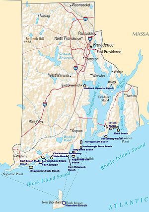
Rhode Island
The state of Rhode Island and Providence Plantations, more commonly referred to as Rhode Island , is a state in the New England region of the United States. It is the smallest U.S. state by area...
's beaches line the 384 miles (618 km) of tidal shoreline across the Narragansett Bay
Narragansett Bay
Narragansett Bay is a bay and estuary on the north side of Rhode Island Sound. Covering 147 mi2 , the Bay forms New England's largest estuary, which functions as an expansive natural harbor, and includes a small archipelago...
:
- Block IslandBlock IslandBlock Island is part of the U.S. state of Rhode Island and is located in the Atlantic Ocean approximately south of the coast of Rhode Island, east of Montauk Point on Long Island, and is separated from the Rhode Island mainland by Block Island Sound. The United States Census Bureau defines Block...
(New ShorehamNew Shoreham, Rhode IslandNew Shoreham is the town located on Block Island in Washington County, Rhode Island, United States. The population was 1,051 at the 2010 census...
)- Crescent Beach
- Surfers Beach
- Mansion Beach
- CharlestownCharlestown, Rhode IslandCharlestown is a town in Washington County, Rhode Island, United States. The population was 7,827 at the 2010 census.-History:Charlestown is named after King Charles II, and was incorporated in 1738. The area was formerly part of the town of Westerly...
- Burlingame State Park (beach area), Burlingame State Park
- Charlestown Breachway State Beach, Charlestown Breachway
- East Beach State Beach, Ninigret Conservation Area
- MiddletownMiddletown, Rhode IslandMiddletown is a town in Newport County, Rhode Island, United States. The population was 16,150 at the 2010 census. It lies to the south of Portsmouth and to the north of Newport on Aquidneck Island, hence the name "Middletown."-Geography:...
- Sachuest Beach (Second Beach)
- Third Beach
- NarragansettNarragansett, Rhode IslandNarragansett is a town in Washington County, Rhode Island, United States. The population was 15,868 at the 2010 census, but there is a greater population in the summer. The nickname for the town is "Gansett". The town of Narragansett occupies a narrow strip of land running along the eastern bank...
- Narragansett Town Beach
- Roger Wheeler State Beach
- Salty Brine State Beach
- Scarborough State Beach Complex - North & South
- NewportNewport, Rhode IslandNewport is a city on Aquidneck Island in Newport County, Rhode Island, United States, about south of Providence. Known as a New England summer resort and for the famous Newport Mansions, it is the home of Salve Regina University and Naval Station Newport which houses the United States Naval War...
- Easton's Beach (First Beach)
- Fort Adams State Beach, Fort Adams State Park
- Gooseberry BeachGooseberry BeachGooseberry Beach is a beach located in Newport, Rhode Island off Ocean Drive. It is a private beach, but also open to the public. The beach is located between Bailey's Beach and Hazard's Beach....
- South KingstownSouth Kingstown, Rhode IslandSouth Kingstown is a town in Washington County, Rhode Island, United States. The population was 30,639 at the 2010 census.South Kingstown includes the villages of Kingston, West Kingston, Wakefield, Peace Dale, Snug Harbor, Tuckertown, East Matunuck, Matunuck, Green Hill, and Perryville. Peace...
- East Matunuck State Beach
- Tiverton
- Grinnell's Beach
- Fogland Beach
- WarwickWarwick, Rhode IslandWarwick is a city in Kent County, Rhode Island, United States. It is the second largest city in the state, with a population of 82,672 at the 2010 census. Its mayor has been Scott Avedisian since 2000...
- Goddard Memorial State Beach, Goddard Memorial State Park
- Westerly
- Misquamicut State BeachMisquamicut State BeachMisquamicut State Beach is a state park in Westerly Rhode Island. It is a part of Misquamicut Beach which is a seven mile length of beach that stretches from Weekapaug in the east, westward to Watch Hill, which was called Noyes Beach after Reverend James Noyes from the 18th century to the late...
- Misquamicut State Beach
Vermont
Lake ChamplainLake Champlain
Lake Champlain is a natural, freshwater lake in North America, located mainly within the borders of the United States but partially situated across the Canada—United States border in the Canadian province of Quebec.The New York portion of the Champlain Valley includes the eastern portions of...
Beaches
- BurlingtonBurlington, VermontBurlington is the largest city in the U.S. state of Vermont and the shire town of Chittenden County. Burlington lies south of the U.S.-Canadian border and some south of Montreal....
- North Beach
- ColchesterColchester, VermontColchester is a town in Chittenden County, Vermont, United States. The population was 17,067 at the 2010 census. It is the fourth-largest municipality and second-largest town in Vermont by population.-Geography:...
- Mallets Bay
- ShelburneShelburne, VermontShelburne is a town in southwestern Chittenden County, Vermont, United States, along the shores of Lake Champlain. The population was 7,144 at the 2010 census.-History:...
- Shelburne Bay