

List of airports in the San Francisco Bay area
Encyclopedia
San Francisco Bay
San Francisco Bay is a shallow, productive estuary through which water draining from approximately forty percent of California, flowing in the Sacramento and San Joaquin rivers from the Sierra Nevada mountains, enters the Pacific Ocean...
, including the major cities of San Jose
San Jose, California
San Jose is the third-largest city in California, the tenth-largest in the U.S., and the county seat of Santa Clara County which is located at the southern end of San Francisco Bay...
, San Francisco
San Francisco, California
San Francisco , officially the City and County of San Francisco, is the financial, cultural, and transportation center of the San Francisco Bay Area, a region of 7.15 million people which includes San Jose and Oakland...
, and Oakland
Oakland, California
Oakland is a major West Coast port city on San Francisco Bay in the U.S. state of California. It is the eighth-largest city in the state with a 2010 population of 390,724...
, as well as surrounding communities. This list includes only public-use and/or government-owned airports in the eleven counties (the nine counties that border the bay, plus Santa Cruz and San Benito Counties) that make up the Census Bureau's San Jose-San Francisco-Oakland, CA Combined Statistical Area, also known as the San Francisco Bay Area.
International airportInternational airportAn international airport is any airport that can accommodate flights from other countries and are typically equipped with customs and immigration facilities to handle these flights to and from other countries...
s
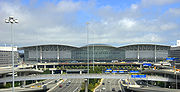
- San Francisco International AirportSan Francisco International AirportSan Francisco International Airport is a major international airport located south of downtown San Francisco, California, United States, near the cities of Millbrae and San Bruno in unincorporated San Mateo County. It is often referred to as SFO...
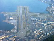
(KSFO) - Class B airspace - Oakland International AirportOakland International AirportOakland International Airport , also known as Metropolitan Oakland International Airport, is a public airport located south of the central business district of Oakland, a city in Alameda County, California, United States...
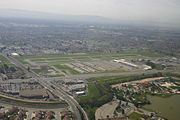
(KOAK) - Class C airspace - Norman Y. Mineta San José International AirportSan Jose International AirportNorman Y. Mineta San Jose International Airport is a city-owned public-use airport serving the city of San Jose in Santa Clara County, California, United States. It is named for San Jose native Norman Yoshio Mineta, who was Transportation Secretary in the Cabinet of George W...
(KSJC) - Class C airspace
Federal airports
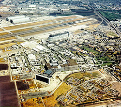
- Moffett Federal AirfieldMoffett Federal AirfieldMoffett Federal Airfield , also known as Moffett Field, is a joint civil-military airport located between northern Mountain View and northern Sunnyvale, California, USA. The airport is near the south end of San Francisco Bay, northwest of San Jose. Formerly a United States Navy facility, the former...
(KNUQ) in Mountain View and Sunnyvale, Santa Clara County - Travis Air Force BaseTravis Air Force BaseTravis Air Force Base is a United States Air Force air base under the operational control of the Air Mobility Command , located three miles east of the central business district of Fairfield, in Solano County, California, United States. The base is named for Brigadier General Robert F...
(KSUU) in Fairfield, Solano County
General AviationGeneral aviationGeneral aviation is one of the two categories of civil aviation. It refers to all flights other than military and scheduled airline and regular cargo flights, both private and commercial. General aviation flights range from gliders and powered parachutes to large, non-scheduled cargo jet flights...
towered airports
Control tower
A control tower, or more specifically an Air Traffic Control Tower , is the name of the airport building from which the air traffic control unit controls the movement of aircraft on and around the airport. Control towers are also used to control the traffic for other forms of transportation such...
. These airports have Class D airspace.
- Concord/Buchanan Field Airport (KCCR) in Concord, Contra Costa County
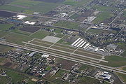
- Hayward Executive AirportHayward Executive AirportHayward Executive Airport is a general aviation towered airport located in Hayward, California, USA, near the eastern shore of San Francisco Bay.- History :...
(KHWD) in Hayward, Alameda County - Livermore Municipal AirportLivermore Municipal AirportLivermore Municipal Airport is located in Livermore, California, USA, east of the San Francisco Bay between San Jose and Oakland.Sierra Academy of Aeronautics operated one of its training centers on the north ramp until December 2007. Other flight schools at Livermore Municipal Airport are Ahart...
(KLVK) in Livermore, Alameda County - Napa County AirportNapa County AirportNapa County Airport , also known as Napa Valley Airport, is a public airport located five miles south of Napa, in Napa County, California, USA. It has three runways....
(KAPC) in Napa, Napa County - Palo Alto Airport (KPAO) in Palo Alto, Santa Clara County
- Reid-Hillview Airport (KRHV) in San Jose, Santa Clara County
- San Carlos AirportSan Carlos AirportSan Carlos Airport is a county-owned public use airport in San Mateo County, California, United States. It is located two nautical miles northeast of the central business district of San Carlos, California. The FAA's National Plan of Integrated Airport Systems classifies San Carlos as a reliever...
(KSQL) in San Carlos, San Mateo County - Charles M. Schulz - Sonoma County AirportCharles M. Schulz - Sonoma County AirportCharles M. Schulz – Sonoma County Airport is a county-owned public-use airport located 6 nautical miles northwest of downtown Santa Rosa, a city in Sonoma County, California, United States. It serves the county and surrounding areas of Wine Country in California.The airport is named after Charles M...
(KSTS) in Santa Rosa, Sonoma County - served by a commercial airline, Horizon AirHorizon AirHorizon Air Industries, Inc. is a regional low-cost airline based in SeaTac, Washington, United States. It is the eighth largest regional airline in the USA, serving 52 cities in the United States, Canada and Mexico....
General Aviation non-towered airports
Instrument approach
For aircraft operating under instrument flight rules , an instrument approach or instrument approach procedure is a series of predetermined maneuvers for the orderly transfer of an aircraft under instrument flight conditions from the beginning of the initial approach to a landing, or to a point...
, or Class G airspace otherwise.
- Angwin-Parrett FieldAngwin-Parrett FieldAngwin-Parrett Field is a public use airport located one nautical mile east of the central business district of Angwin, in Napa County, California, United States. It is owned by Pacific Union College.It is also known as Virgil O. Parrett Field...
(2O3) in Angwin, Napa County - Byron AirportByron AirportByron Airport is a county-owned public-use airport located two miles south of the central business district of Byron, a community in Contra Costa County, California, United States...
(C83) in Byron, Contra Costa County - Cloverdale Municipal AirportCloverdale Municipal AirportCloverdale Municipal Airport is a public airport located three miles southeast of Cloverdale, serving Sonoma County, California, USA. The airport is mostly used for general aviation...
(O60) in Cloverdale, Sonoma County - Gnoss FieldGnoss FieldMarin County Airport or Gnoss Field , formerly O56, is a public airport located two miles northeast of Novato, serving Marin County, California, USA. The airport covers and has one runway and one helipad. It is used mostly for general aviation.Although most U.S...
(KDVO) in Novato, Marin County - Half Moon Bay AirportHalf Moon Bay AirportHalf Moon Bay Airport is a county-owned public use airport in San Mateo County, California, United States. It is located five nautical miles northwest of the central business district of Half Moon Bay, California. The airport is on the Pacific Coast, south of San Francisco.-History:The Half Moon...
(KHAF) in Half Moon Bay, San Mateo County - Healdsburg Municipal AirportHealdsburg Municipal AirportHealdsburg Municipal Airport is a public airport located three miles northwest of Healdsburg, serving Sonoma County, California, USA...
(KHES) in Healdsburg, Sonoma County - Hollister Municipal AirportHollister Municipal AirportHollister Municipal Airport is a city-owned public-use airport located three nautical miles north of the central business district of Hollister, a city in San Benito County, California, United States.Although most U.S...
(KCVH) in Hollister, San Benito County - Nut Tree AirportNut Tree AirportNut Tree Airport is a county-owned public-use airport located two nautical miles northeast of the central business district of Vacaville, in Solano County, California, United States.The airport is near the junction of Interstates 80 and 505...
(KVCB) in Vacaville, Solano County - Petaluma Municipal AirportPetaluma Municipal AirportPetaluma Municipal Airport is a public airport located one mile northeast of the central business district of Petaluma, a city in Sonoma County, California, USA. The airport covers and has one runway 3601 x 75 feet. It is mostly used for general aviation.-External links:*-See also:*List of...
(O69) in Petaluma, Sonoma County - Rio Vista Municipal AirportRio Vista Municipal AirportRio Vista Municipal Airport was a public airport located three miles northwest of Rio Vista, serving Solano County, California, USA. This general aviation airport covers and has two runways and one helipad. The airport is the current base of operations for the...
(O88) in Rio Vista, Solano County - Sonoma SkyparkSonoma SkyparkSonoma Skypark is a public-use airport located three miles southeast of the central business district of Sonoma, a city in Sonoma County, California, United States...
(0Q9) in Sonoma, Sonoma County - Sonoma Valley AirportSonoma Valley AirportSonoma Valley Airport is a public-use airstrip opened on August 1959 in Schellville, Sonoma, California, USA. Located south of central district of Sonoma and north of San Francisco , the airfield offers two asphalt runways, of which the 17/35 is restricted, with prior permission required.Open...
(0Q3) in Sonoma, Sonoma County - South County AirportSouth County AirportSouth County Airport of Santa Clara County, colloquially South County Airport, is a public non-towered airport located one mile east of San Martin, serving Santa Clara County, California, U.S.A. This general aviation airport covers and has one runway. A self-service fueling facility offers...
(E16) in San Martin, Santa Clara County - Watsonville Municipal AirportWatsonville Municipal AirportWatsonville Municipal Airport is a public airport located three miles northwest of the central business district of Watsonville, a city in Santa Cruz County, California, USA. The airport covers and has two runways...
(KWVI) in Watsonville, Santa Cruz County
Notable historical airports
- Naval Air Station AlamedaNaval Air Station AlamedaNaval Air Station Alameda was a United States Navy Naval Air Station in Alameda, California, on San Francisco Bay.NAS Alameda had two runways: 07-25 and 13-31...
in Alameda, Alameda County (closed 1997) - Alum Rock AirportAlum Rock AirportThe Alum Rock Airport was an early airport in the town of Alum Rock, California. It was in an area now in the city limits of San Jose near the intersection of Alum Rock Avenue and Capitol Avenue. The airport was established in 1919 by Reserve Lieutenant Johnny Johnston after returning from World...
in San Jose, Santa Clara County (closed approximately 1936) - Crissy FieldCrissy FieldCrissy Field is a former airfield, now a part of the Golden Gate National Parks Conservancy in San Francisco, California, United States. Historically a part of the Presidio of San Francisco, Crissy Field was closed as an airfield and eventually the National Park Service took control over it...
in the City and County of San Francisco (airfield closed 1974) - Hamilton Air Force BaseHamilton Air Force BaseHamilton Air Force Base was a United States Air Force base located along the western shore of San Pablo Bay, south of Novato, California.-History:...
in Novato, Marin County (closed 1996) - Santa Cruz Sky ParkSanta Cruz Sky ParkSanta Cruz Sky Park was an airport located in Scotts Valley, California, within Santa Cruz County.-Historical Timeline:-Sources:* 1 Appendix A Santa Cruz Sky Park was an airport located in Scotts Valley, California, within Santa Cruz County.-Historical Timeline:-Sources:* 1 Appendix A Santa Cruz...
in Scotts Valley, Santa Cruz County (closed 1983)