

List of Ultras in the Caribbean
Encyclopedia
The following is a sortable table of the seven ultra prominent mountain peaks
on the islands of the Caribbean Sea
. There are five Ultra
s on Hispaniola
and one each on Jamaica
and Cuba
.
Topographic elevation is the vertical distance above the reference geoid
, a precise mathematical model of the Earth's
sea level
as an equipotential
gravitational surface
. Topographic prominence
is the elevation difference between the summit
and the highest or key col to a higher summit. Topographic isolation
is the minimum great circle
distance to a point of higher elevation.
This article defines a significant summit as a summit with at least 100 meters (328.1 feet) of topographic prominence, and a major summit as a summit with at least 500 meters (1640.4 feet) of topographic prominence. An ultra-prominent summit is a summit with at least 1500 meters (4921.3 feet) of topographic prominence.
Ultra prominent peak
An ultra prominent peak, or Ultra for short, is a mountain with a topographic prominence of or more. There are a total of roughly 1,524 such peaks in the world. Some are famous even to non-climbers, such as Mount Everest, Aconcagua, and Mount McKinley , while others are much more obscure...
on the islands of the Caribbean Sea
Caribbean Sea
The Caribbean Sea is a sea of the Atlantic Ocean located in the tropics of the Western hemisphere. It is bounded by Mexico and Central America to the west and southwest, to the north by the Greater Antilles, and to the east by the Lesser Antilles....
. There are five Ultra
Ultra
Ultra was the designation adopted by British military intelligence in June 1941 for wartime signals intelligence obtained by "breaking" high-level encrypted enemy radio and teleprinter communications at the Government Code and Cypher School at Bletchley Park. "Ultra" eventually became the standard...
s on Hispaniola
Hispaniola
Hispaniola is a major island in the Caribbean, containing the two sovereign states of the Dominican Republic and Haiti. The island is located between the islands of Cuba to the west and Puerto Rico to the east, within the hurricane belt...
and one each on Jamaica
Jamaica
Jamaica is an island nation of the Greater Antilles, in length, up to in width and 10,990 square kilometres in area. It is situated in the Caribbean Sea, about south of Cuba, and west of Hispaniola, the island harbouring the nation-states Haiti and the Dominican Republic...
and Cuba
Cuba
The Republic of Cuba is an island nation in the Caribbean. The nation of Cuba consists of the main island of Cuba, the Isla de la Juventud, and several archipelagos. Havana is the largest city in Cuba and the country's capital. Santiago de Cuba is the second largest city...
.
Topographic elevation is the vertical distance above the reference geoid
Geoid
The geoid is that equipotential surface which would coincide exactly with the mean ocean surface of the Earth, if the oceans were in equilibrium, at rest , and extended through the continents . According to C.F...
, a precise mathematical model of the Earth's
Earth
Earth is the third planet from the Sun, and the densest and fifth-largest of the eight planets in the Solar System. It is also the largest of the Solar System's four terrestrial planets...
sea level
Sea level
Mean sea level is a measure of the average height of the ocean's surface ; used as a standard in reckoning land elevation...
as an equipotential
Equipotential
Equipotential or isopotential in mathematics and physics refers to a region in space where every point in it is at the same potential. This usually refers to a scalar potential , although it can also be applied to vector potentials...
gravitational surface
Surface
In mathematics, specifically in topology, a surface is a two-dimensional topological manifold. The most familiar examples are those that arise as the boundaries of solid objects in ordinary three-dimensional Euclidean space R3 — for example, the surface of a ball...
. Topographic prominence
Topographic prominence
In topography, prominence, also known as autonomous height, relative height, shoulder drop , or prime factor , categorizes the height of the mountain's or hill's summit by the elevation between it and the lowest contour line encircling it and no higher summit...
is the elevation difference between the summit
Summit (topography)
In topography, a summit is a point on a surface that is higher in elevation than all points immediately adjacent to it. Mathematically, a summit is a local maximum in elevation...
and the highest or key col to a higher summit. Topographic isolation
Topographic isolation
The topographic isolation of a summit is the minimum horizontal distance to the nearest point of higher elevation. Topographic isolation represents a radius of dominance in which the summit is the highest point. Topographic isolation can be calculated for small hills and islands as well as for...
is the minimum great circle
Great circle
A great circle, also known as a Riemannian circle, of a sphere is the intersection of the sphere and a plane which passes through the center point of the sphere, as opposed to a general circle of a sphere where the plane is not required to pass through the center...
distance to a point of higher elevation.
This article defines a significant summit as a summit with at least 100 meters (328.1 feet) of topographic prominence, and a major summit as a summit with at least 500 meters (1640.4 feet) of topographic prominence. An ultra-prominent summit is a summit with at least 1500 meters (4921.3 feet) of topographic prominence.
Most prominent summits
| Rank Ranking A ranking is a relationship between a set of items such that, for any two items, the first is either 'ranked higher than', 'ranked lower than' or 'ranked equal to' the second.... |
Mountain Peak Summit (topography) In topography, a summit is a point on a surface that is higher in elevation than all points immediately adjacent to it. Mathematically, a summit is a local maximum in elevation... |
Country Caribbean The Caribbean is a crescent-shaped group of islands more than 2,000 miles long separating the Gulf of Mexico and the Caribbean Sea, to the west and south, from the Atlantic Ocean, to the east and north... |
Island | Elevation | Prominence Topographic prominence In topography, prominence, also known as autonomous height, relative height, shoulder drop , or prime factor , categorizes the height of the mountain's or hill's summit by the elevation between it and the lowest contour line encircling it and no higher summit... |
Isolation Topographic isolation The topographic isolation of a summit is the minimum horizontal distance to the nearest point of higher elevation. Topographic isolation represents a radius of dominance in which the summit is the highest point. Topographic isolation can be calculated for small hills and islands as well as for... |
|---|---|---|---|
| 1 | Pico Duarte Pico Duarte Pico Duarte is the highest peak in all the Caribbean islands. It lies in the Cordillera Central range, the greatest of the Dominican Republic's mountain chains. The Cordillera Central extends from the plains between San Cristóbal and Baní to the northwestern peninsula of Haiti, where it is known as... |
Island of Hispaniola |
|
| 2 | Pic la Selle Pic la Selle Pic la Selle , also called Morne La Selle, is the highest peak in Haiti with a height of 2,680 meters above sea level. The mountain is part of the Chaîne de la Selle mountain range. It is located in the Ouest administrative department.... |
Island of Hispaniola |
|
| 3 | Blue Mountain Peak Blue Mountain Peak Blue Mountain Peak is the highest mountain in Jamaica at 2,256 metres . It is the home of Blue Mountain coffee and their famous tours. Blue Mountain Peak is the second highest peak in the Caribbean after Pico Duarte of the Dominican Republic... |
Island of Jamaica |
|
| 4 | Pic Macaya Pic Macaya Pic Macaya is the second highest mountain in Haiti and the fifth highest in the Caribbean, rising to an elevation of 2,347 meters above sea level.The mountain is located in the Pic Macaya National Park.... |
Island of Hispaniola |
|
| 5 | Pico Real del Turquino | Island of Cuba |
|
| 6 | Loma Gajo en Medio | Island of Hispaniola |
|
| 7 | Loma Alto de la Bandera | Island of Hispaniola |
|
See also
- CaribbeanCaribbeanThe Caribbean is a crescent-shaped group of islands more than 2,000 miles long separating the Gulf of Mexico and the Caribbean Sea, to the west and south, from the Atlantic Ocean, to the east and north...
- Geography of the Caribbean
- Islands of the Caribbean
- :Category:Mountains of the Caribbean
- commons:Category:Mountains of the Caribbean
- :Category:Mountains of the Caribbean
- Islands of the Caribbean
- Geography of the Caribbean
- Physical geographyPhysical geographyPhysical geography is one of the two major subfields of geography. Physical geography is that branch of natural science which deals with the study of processes and patterns in the natural environment like the atmosphere, biosphere and geosphere, as opposed to the cultural or built environment, the...
- TopographyTopographyTopography is the study of Earth's surface shape and features or those ofplanets, moons, and asteroids...
- Topographic elevation
- Topographic isolationTopographic isolationThe topographic isolation of a summit is the minimum horizontal distance to the nearest point of higher elevation. Topographic isolation represents a radius of dominance in which the summit is the highest point. Topographic isolation can be calculated for small hills and islands as well as for...
- Topographic prominenceTopographic prominenceIn topography, prominence, also known as autonomous height, relative height, shoulder drop , or prime factor , categorizes the height of the mountain's or hill's summit by the elevation between it and the lowest contour line encircling it and no higher summit...
- Topographic summit
- Topography
- Lists of mountains
- Mountain peaks of greater North America
- The 356 Ultra-prominent mountain peaks of greater North America
- The 39 Ultra-prominent mountain peaks of Greenland
- The 142 Ultra-prominent mountain peaks of Canada
- The 129 Ultra-prominent mountain peaks of the United States
- The 65 Ultra-prominent mountain peaks of Alaska
- The 9 Ultra-prominent mountain peaks of California
- The 3 Ultra-prominent mountain peaks of Colorado
- The 28 Ultra-prominent mountain peaks of México
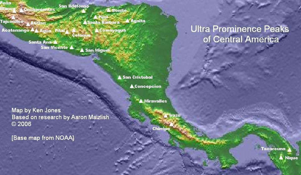
- The 23 Ultra-prominent mountain peaks of Central America
- The 7 Ultra-prominent mountain peaks of the Caribbean
- The 356 Ultra-prominent mountain peaks of greater North America
- Mountain peaks of GreenlandMountain peaks of GreenlandThis article comprises three sortable tables of major mountain peaks of Greenland. For this article, Greenland includes all of Kalaallit Nunaat including the Island of Greenland and surrounding islands....
- Mountain peaks of CanadaMountain peaks of CanadaThis article comprises three sortable tables of major mountain peaks of Canada.Topographic elevation is the vertical distance above the reference geoid, a precise mathematical model of the Earth's sea level as an equipotential gravitational surface. Topographic prominence is the elevation...
- Mountain peaks of the Rocky MountainsMountain peaks of the Rocky MountainsThis article comprises three sortable tables of major mountain peaks of the Rocky Mountains of North America.Topographic elevation is the vertical distance above the reference geoid, a precise mathematical model of the Earth's sea level as an equipotential gravitational surface...
- Mountain peaks of the United StatesMountain peaks of the United StatesThis article comprises three sortable tables of the major mountain peaks of the United States of America.Topographic elevation is the vertical distance above the reference geoid, a precise mathematical model of the Earth's sea level as an equipotential gravitational surface...
- Mountain peaks of AlaskaMountain peaks of AlaskaThis article comprises three sortable tables of mountain peaks of the U.S. State of Alaska.Topographic elevation is the vertical distance above the reference geoid, a precise mathematical model of the Earth's sea level as an equipotential gravitational surface. Topographic prominence is the...
- Mountain peaks of CaliforniaMountain peaks of CaliforniaThis article comprises three sortable tables of major mountain peaks of the U.S. State of California.Topographic elevation is the vertical distance above the reference geoid, a precise mathematical model of the Earth's sea level as an equipotential gravitational surface...
- Mountain peaks of ColoradoMountain peaks of ColoradoThis article comprises three sortable tables of the major mountain peaks of the U.S. State of Colorado.Topographic elevation is the vertical distance above the reference geoid, a precise mathematical model of the Earth's sea level as an equipotential gravitational surface...
- Mountain peaks of Alaska
- Mountain peaks of MéxicoMountain peaks of MexicoThis article comprises three sortable tables of the major mountain peaks of Mexico.Topographic elevation is the vertical distance above the reference geoid, a precise mathematical model of the Earth's sea level as an equipotential gravitational surface. Topographic prominence is the elevation...
- Mountain peaks of Central AmericaMountain peaks of Central AmericaThis article comprises three sortable tables of major mountain peaks of Central America. This article defines Central America as the seven nations of Belize, Costa Rica, El Salvador, Guatemala, Honduras, Nicaragua, and Panama....
- Mountain peaks of the CaribbeanMountain peaks of the CaribbeanThis article comprises three sortable tables of major mountain peaks of the islands of the Caribbean Sea.Topographic elevation is the vertical distance above the reference geoid, a precise mathematical model of the Earth's sea level as an equipotential gravitational surface...
- The 7 Ultra-prominent mountain peaks of the Caribbean
- Mountain peaks of greater North America