

List of San Francisco Municipal Railway lines
Encyclopedia
San Francisco Municipal Railway
The San Francisco Municipal Railway is the public transit system for the city and county of San Francisco, California. In 2006, it served with an operating budget of about $700 million...
(Muni) is the public transit system for San Francisco, California
California
California is a state located on the West Coast of the United States. It is by far the most populous U.S. state, and the third-largest by land area...
. A part of the San Francisco Municipal Transportation Agency, it served 47.35 square miles (123 km²) with an operating budget of $810 million in 2010. Muni is the eighth-largest transit system in the United States
United States
The United States of America is a federal constitutional republic comprising fifty states and a federal district...
, with 229,715,700 riders in 2009.
Muni began service on December 28, 1912, when the A Geary-Park line was inaugurated, running between the Financial District and the Richmond District on the western side of the city. Expansion of the system and consolidation with other transit companies eventually made Muni the city's sole public transit operator in 1952, when it acquired the bankrupt California Street Cable Railroad
California Street Cable Railroad
The California Street Cable Railroad was a long-serving cable car operator in San Francisco, founded by Leland Stanford. The company's first line opened on California Street in 1878 and is still in operation, being the oldest cable car line still in operation.The company remained independent until...
. Subsequent changes and adjustments to the system gave rise to the lines in use today.
The system consists of 84 routes serving the city and some parts of Daly City
Daly City, California
Daly City is the largest city in San Mateo County, California, United States, with a 2010 population of 101,123. Located immediately south of San Francisco, it is named in honor of businessman and landowner John Daly.-History:...
and Marin County
Marin County, California
Marin County is a county located in the North San Francisco Bay Area of the U.S. state of California, across the Golden Gate Bridge from San Francisco. As of 2010, the population was 252,409. The county seat is San Rafael and the largest employer is the county government. Marin County is well...
. The names of all Muni routes, except those of cable car
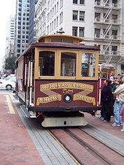
San Francisco cable car system
The San Francisco cable car system is the world's last permanently operational manually operated cable car system, in the US sense of a tramway whose cars are pulled along by cables embedded in the street. It is an icon of San Francisco, California...
lines, have two parts: a number or letter and a street, neighborhood, or landmark, for example, the "1 California" line. The bus and trolleybus lines have number designations, the rail lines have letters, and the cable car lines are typically referred to only by name (Powell-Mason, Powell-Hyde and California). However, Muni maps abbreviate the cable car route names to PM, PH and C, and they are given route numbers 59, 60, and 61, respectively, for use in Muni internal operations. The direction traveled on bus, trolleybus, and rail lines is identified as "inbound" or "outbound"; the inbound direction generally goes toward downtown and the outbound direction heads away from downtown.
Cable car lines
| Line | Termini | Neighborhoods served | Links | |
|---|---|---|---|---|
| California (C) | California and Market | California and Van Ness Van Ness Avenue (San Francisco) Van Ness Avenue is a north-south thoroughfare in San Francisco, California, running from Market St north to the Bay. Originally named Marlette Street, the street was renamed Van Ness Avenue in honor of the city's seventh mayor, James Van Ness. Van Ness Avenue begins at Market Street near the Civic... |
Financial District, Nob Hill | Schedule Route map (PDF) |
| Powell-Hyde (PH) | Powell and Market | Hyde and Beach | Union Square, Chinatown, Russian Hill, Fisherman's Wharf | Schedule Route map (PDF) |
| Powell-Mason (PM) | Powell and Market | Taylor and Bay | Union Square, Chinatown, North Beach, Fisherman's Wharf | Schedule Route map (PDF) |
Muni Metro and historic streetcar lines
| Line | Termini | Neighborhoods served | Links | |
|---|---|---|---|---|
| 2F Market & Wharves | Jones and Beach Jones and Beach Station Jones and Beach Station is a light rail station in San Francisco, California, serving as the terminus of the San Francisco Municipal Railway's F Market & Wharves heritage railway line. It is located on Jones Street between Beach and Jefferson Streets.... |
Market and Castro | The Castro, Civic Center, Financial District, Embarcadero, Fisherman's Wharf | Schedule Route map (PDF) |
| 3J Church J Church The J Church is a Muni Metro railway line in San Francisco, California mainly serving the Noe Valley and Balboa Park neighborhoods, connecting them to downtown. It began as one of San Francisco's streetcar lines in 1917, and was converted to modern light rail operation with the creation of the Muni... |
Embarcadero Station Embarcadero Station Embarcadero is a BART and Muni Metro station in the Financial District of San Francisco. The easternmost stop on the Market Street Subway, Embarcadero acts as a major hub for passenger movement throughout the San Francisco Bay Area... |
Balboa Park Station | Financial District, Civic Center, Noe Valley Noe Valley, San Francisco, California -Location:Its borders are generally considered to be 22nd Street to the north, Randall Street to the south, Dolores Street to the east, and Grand View Avenue to the west. These borders are understood to be somewhat flexible, particularly by real estate agents... , Balboa Park |
Schedule Route map (PDF) |
| 4K Ingleside K Ingleside The K Ingleside is a Muni Metro line in San Francisco, California, mainly serving the West Portal and Ingleside neighborhoods. It was one of San Francisco's streetcar lines in the early 20th century, and was converted to modern light rail operation with the creation of the Muni Metro system in the... |
Embarcadero Station Outbound terminal |
Balboa Park Station | Financial District, Civic Center, The Castro, Forest Hill Forest Hill, San Francisco, California -Location:Forest Hill is located near the middle of the city, south of the Inner Sunset and northeast of West Portal. Boundaries are roughly Seventh Avenue/Laguna Honda Boulevard to the east, Taraval Street to the south, and 14th Avenue to the west.-History:... , West Portal West Portal, San Francisco, California West Portal is a small neighborhood in San Francisco, California. Like adjacent Forest Hill and St. Francis Wood, West Portal is an affluent, primarily residential area of the City... , St. Francis Wood St. Francis Wood, San Francisco, California St. Francis Wood is an affluent residential neighborhood located in southwestern San Francisco, California, south of the West Portal neighborhood and west of Mount Davidson.... , Ingleside, Balboa Park |
Schedule Route map (PDF) |
| West Portal Station West Portal Station West Portal Station is a Muni Metro station in the West Portal neighborhood in San Francisco, California. It is built around the entrance to the Twin Peaks Tunnel, which connects with the Market Street Subway and runs through the city to the Embarcadero... Inbound terminal |
||||
| 5L Taraval L Taraval The L Taraval is a Muni Metro line in San Francisco, California, mainly serving the Parkside District, an area which is immediately south of the Sunset District and which is regarded by some as the southern part of the Sunset District... |
Embarcadero Station | 46th Ave. and Wawona 46th Avenue and Wawona 46th Avenue and Wawona is a station on the San Francisco Municipal Railway light rail network's L Taraval line. It is located in the Sunset District neighborhood. The terminus of the line, this stop is meant to serve the San Francisco Zoo... San Francisco Zoo San Francisco Zoo The San Francisco Zoo, housing more than 260 animal species, is a zoo located in the southwestern corner of San Francisco, California, between Lake Merced and the Pacific Ocean along the Great Highway... |
Financial District, Civic Center, The Castro, Forest Hill Forest Hill, San Francisco, California -Location:Forest Hill is located near the middle of the city, south of the Inner Sunset and northeast of West Portal. Boundaries are roughly Seventh Avenue/Laguna Honda Boulevard to the east, Taraval Street to the south, and 14th Avenue to the west.-History:... , West Portal West Portal, San Francisco, California West Portal is a small neighborhood in San Francisco, California. Like adjacent Forest Hill and St. Francis Wood, West Portal is an affluent, primarily residential area of the City... , Sunset |
Schedule Route map (PDF) |
| 6M Ocean View | Embarcadero Station | Balboa Park Station | Financial District, Civic Center, The Castro, Forest Hill Forest Hill, San Francisco, California -Location:Forest Hill is located near the middle of the city, south of the Inner Sunset and northeast of West Portal. Boundaries are roughly Seventh Avenue/Laguna Honda Boulevard to the east, Taraval Street to the south, and 14th Avenue to the west.-History:... , West Portal West Portal, San Francisco, California West Portal is a small neighborhood in San Francisco, California. Like adjacent Forest Hill and St. Francis Wood, West Portal is an affluent, primarily residential area of the City... , Stonestown Galleria Stonestown Galleria Stonestown Galleria is a shopping mall in San Francisco, California, anchored by Nordstrom, Macy's, and Ode Books, formerly Borders Books & Music... , Parkmerced, Balboa Park |
Schedule Route map (PDF) |
| 7N Judah N Judah The N Judah is a Muni Metro line in San Francisco, California, so called as it runs along Judah Street for much of its length, named after railroad engineer Theodore Judah. It links downtown San Francisco to the Cole Valley and Sunset neighborhoods. It is the busiest line in the Muni Metro system... |
4th St. and King San Francisco 4th and King Street Station San Francisco 4th and King Street or 4th and King station or Caltrain Depot is the northern terminus of the Caltrain commuter rail line that serves San Francisco Peninsula and Santa Clara Valley, and is a major regional transit hub... Weekdays |
Judah and La Playa Judah and La Playa Judah and La Playa is a station on the San Francisco Municipal Railway light rail network's N Judah line. It is located in the Sunset District neighborhood. It provides access to the surfing hotspot of Ocean Beach and the popular recreational trails along the Great Highway... Ocean Beach Ocean Beach, San Francisco, California Ocean Beach is a beach that runs along the west coast of San Francisco, California, United States, at the Pacific Ocean. It is adjacent to Golden Gate Park, the Richmond District and the Sunset District. The Great Highway runs alongside the beach, and Cliff House and the site of the former Sutro... |
Mission Bay Mission Bay, San Francisco, California Mission Bay is a neighborhood in San Francisco, California.-Location:Mission Bay is roughly bounded by Townsend Street on the north, Third Street and San Francisco Bay on the east, Mariposa Street on the south, and 7th Street and Interstate 280 on the west.-History:It was created in 1998 by the... , Embarcadero, Financial District, Civic Center, Duboce Triangle Duboce Triangle, San Francisco, California The Duboce Triangle neighborhood is located near the center of San Francisco, just below the hilly slopes of Buena Vista between the neighborhoods of the Castro/Eureka Valley, the Mission District, and the Lower Haight.... , Sunset |
Schedule Route map (PDF) |
| Embarcadero Station Weekends |
||||
| 8S Castro Shuttle S Castro Shuttle The S Castro Shuttle is a Muni Metro line in San Francisco, California. It runs from Embarcadero Station downtown to the Castro Street Station during peak periods on weekdays... Game days only |
Embarcadero Station | Castro Street Station Castro Street Station Castro Street Station is a Muni Metro station at the intersection of Market Street, Castro Street, and 17th Street in The Castro district of San Francisco, California... |
The Castro, Civic Center, Financial District, Embarcadero | Schedule |
| 9T Third Street | West Portal Station West Portal Station West Portal Station is a Muni Metro station in the West Portal neighborhood in San Francisco, California. It is built around the entrance to the Twin Peaks Tunnel, which connects with the Market Street Subway and runs through the city to the Embarcadero... Inbound terminal |
Sunnydale Station Sunnydale Station Sunnydale Station is an island platform light rail station of the San Francisco Municipal Railway's Muni Metro system located in the median of Bayshore Boulevard at Sunnydale Avenue in Visitacion Valley, San Francisco, California. This is the terminal for the T Third Street Muni Metro line... |
West Portal West Portal, San Francisco, California West Portal is a small neighborhood in San Francisco, California. Like adjacent Forest Hill and St. Francis Wood, West Portal is an affluent, primarily residential area of the City... , Forest Hill Forest Hill, San Francisco, California -Location:Forest Hill is located near the middle of the city, south of the Inner Sunset and northeast of West Portal. Boundaries are roughly Seventh Avenue/Laguna Honda Boulevard to the east, Taraval Street to the south, and 14th Avenue to the west.-History:... , The Castro, Civic Center, Financial District, Embarcadero, Mission Bay Mission Bay, San Francisco, California Mission Bay is a neighborhood in San Francisco, California.-Location:Mission Bay is roughly bounded by Townsend Street on the north, Third Street and San Francisco Bay on the east, Mariposa Street on the south, and 7th Street and Interstate 280 on the west.-History:It was created in 1998 by the... , Potrero Hill Potrero Hill, San Francisco, California Potrero Hill is a hilly neighborhood in San Francisco, California.-Location:Potrero Hill is located on the eastern side of the city, east of the Mission District and south of SOMA and the newly designated district . It is roughly bordered by 16th Street to the north, Potrero Avenue and U.S... , Bayview-Hunters Point, Visitacion Valley Visitacion Valley, San Francisco, California Visitacion Valley is a neighborhood located in the south eastern quadrant of San Francisco, California.-Location:Visitacion Valley is roughly defined by McLaren Park and Gleneagles Golf Course to the West, Mansell Blvd to the North, Bayview Hill and Candlestick Cove to the East, and the San... |
Schedule Route map (PDF) |
| Embarcadero Station Embarcadero Station Embarcadero is a BART and Muni Metro station in the Financial District of San Francisco. The easternmost stop on the Market Street Subway, Embarcadero acts as a major hub for passenger movement throughout the San Francisco Bay Area... Outbound terminal |
Local bus lines
| † | Trolleybus Trolleybus A trolleybus is an electric bus that draws its electricity from overhead wires using spring-loaded trolley poles. Two wires and poles are required to complete the electrical circuit... |
| * | Peak hours only |
| ** | Sundays and holidays only |
| Line | Termini | Neighborhoods served | Links | |
|---|---|---|---|---|
| 11 California† | Clay and Drumm | Geary Geary Boulevard Geary Boulevard is a major east-west thoroughfare in San Francisco, California, beginning downtown at Market Street near Market Street's intersection with Montgomery Street, and running westbound through downtown, the Civic Center area, the Western Addition, and running for most of its length... and 33rd Ave. |
Financial District, Chinatown, Nob Hill, Pacific Heights, Laurel Heights Laurel Heights, San Francisco, California Laurel Heights is a neighborhood to the south of the Presidio of San Francisco and east of the Richmond District. It is bordered by Geary Boulevard or the University of San Francisco campus to the south, Arguello Boulevard to the west, California Street to the north and Presidio Avenue to the east... , Richmond |
Schedule Route map (PDF) |
| 22 Clement | Steuart and Market Ferry Plaza |
Clement and Park Presidio | Financial District, Japantown Japantown, San Francisco, California comprises about six square city blocks in San Francisco, California, USA. San Francisco's Japantown is the largest and oldest such enclave in the United States.-Location:... , Western Addition Western Addition, San Francisco, California The Western Addition is a neighborhood in San Francisco, California, United States.-Location:The Western Addition is sandwiched between Van Ness Avenue, Golden Gate Park, the Upper and Lower Haight neighborhoods, and Pacific Heights.... , Laurel Heights Laurel Heights, San Francisco, California Laurel Heights is a neighborhood to the south of the Presidio of San Francisco and east of the Richmond District. It is bordered by Geary Boulevard or the University of San Francisco campus to the south, Arguello Boulevard to the west, California Street to the north and Presidio Avenue to the east... , Richmond |
Schedule Route map (PDF) |
| 33 Jackson† | Sutter and Sansome | Presidio and California | Financial District, Japantown Japantown, San Francisco, California comprises about six square city blocks in San Francisco, California, USA. San Francisco's Japantown is the largest and oldest such enclave in the United States.-Location:... , Western Addition Western Addition, San Francisco, California The Western Addition is a neighborhood in San Francisco, California, United States.-Location:The Western Addition is sandwiched between Van Ness Avenue, Golden Gate Park, the Upper and Lower Haight neighborhoods, and Pacific Heights.... , Pacific Heights |
Schedule Route map (PDF) |
| 55 Fulton† | Transbay Terminal San Francisco Transbay Terminal San Francisco Transbay Transit Terminal, or simply Transbay Terminal, was a transportation complex in San Francisco, California, USA, located roughly in the center of the rectangle bounded north–south by Mission Street and Howard Street, and east–west by Beale Street and 2nd Street... |
Cabrillo and La Playa | Financial District, Civic Center, Western Addition Western Addition, San Francisco, California The Western Addition is a neighborhood in San Francisco, California, United States.-Location:The Western Addition is sandwiched between Van Ness Avenue, Golden Gate Park, the Upper and Lower Haight neighborhoods, and Pacific Heights.... , University of San Francisco University of San Francisco The University of San Francisco , is a private, Jesuit/Catholic university located in San Francisco, California. Founded in 1855, USF was established as the first university in San Francisco. It is the second oldest institution for higher learning in California and the tenth-oldest university of... , Golden Gate Park Golden Gate Park Golden Gate Park, located in San Francisco, California, is a large urban park consisting of of public grounds. Configured as a rectangle, it is similar in shape but 20% larger than Central Park in New York, to which it is often compared. It is over three miles long east to west, and about half a... , Richmond, Ocean Beach Ocean Beach, San Francisco, California Ocean Beach is a beach that runs along the west coast of San Francisco, California, United States, at the Pacific Ocean. It is adjacent to Golden Gate Park, the Richmond District and the Sunset District. The Great Highway runs alongside the beach, and Cliff House and the site of the former Sutro... |
Schedule Route map (PDF) |
| 66 Parnassus† | Steuart and Market Ferry Plaza |
Quintara and 14th Ave. | Financial District, Civic Center, Lower Haight Lower Haight, San Francisco, California The Lower Haight is a neighborhood, sometimes referred to as Haight-Fillmore, in San Francisco, California.-Location:The Lower Haight lies generally along Haight Street east of Divisadero Street, and between Oak Street on the north, and Duboce Avenue on south. The eastern boundary is variously... , UCSF, Haight-Ashbury, Cole Valley Cole Valley, San Francisco, California Cole Valley is a small neighborhood in San Francisco.-Location:Its boundaries are usually considered to be Hillway Street to the west, Carmel Street to the south, Clayton Street to the east, and Waller Street to the north... , Inner Sunset |
Schedule Route map (PDF) |
| 99 San Bruno | Main and Mission Mission Street Mission Street is a north-south arterial thoroughfare in San Francisco, California that runs from the city's southern border to its northeast corner. The street and the Mission District through which it runs were named for the Spanish Mission Dolores, several blocks away from the modern route. Only... Weekday daytime |
McLaren Park McLaren Park McLaren Park is a park in south-eastern San Francisco. McLaren Park is the second largest park in San Francisco after Golden Gate Park. The park is surrounded mostly by the Excelsior, Crocker-Amazon, Visitacion Valley, Portola and University Mound neighborhoods.-History:McLaren Park was once a... Weekday daytime |
Financial District, Civic Center, Mission District Mission District, San Francisco, California The Mission District, also commonly called "The Mission", is a neighborhood in San Francisco, California, USA, originally known as "the Mission lands" meaning the lands belonging to the sixth Alta California mission, Mission San Francisco de Asis... , Portola, Visitacion Valley Visitacion Valley, San Francisco, California Visitacion Valley is a neighborhood located in the south eastern quadrant of San Francisco, California.-Location:Visitacion Valley is roughly defined by McLaren Park and Gleneagles Golf Course to the West, Mansell Blvd to the North, Bayview Hill and Candlestick Cove to the East, and the San... , McLaren Park McLaren Park McLaren Park is a park in south-eastern San Francisco. McLaren Park is the second largest park in San Francisco after Golden Gate Park. The park is surrounded mostly by the Excelsior, Crocker-Amazon, Visitacion Valley, Portola and University Mound neighborhoods.-History:McLaren Park was once a... |
Schedule Route map (PDF) |
| Market and 2nd St. Evenings and weekends |
Geneva and Rio Verde Cow Palace Cow Palace Cow Palace is an indoor arena, in Daly City, California, situated on the city's border with neighboring San Francisco, notable as a sporting arena.-History:... Evenings and weekends |
|||
| 1010 Townsend | Jackson and Fillmore Weekdays |
24th St. and Potrero San Francisco General Hospital San Francisco General Hospital is the main public hospital in San Francisco, California, and the only Level I Trauma Center serving San Francisco and northern San Mateo County... |
Pacific Heights, Nob Hill, Financial District, South of Market, Mission Bay Mission Bay, San Francisco, California Mission Bay is a neighborhood in San Francisco, California.-Location:Mission Bay is roughly bounded by Townsend Street on the north, Third Street and San Francisco Bay on the east, Mariposa Street on the south, and 7th Street and Interstate 280 on the west.-History:It was created in 1998 by the... , Potrero Hill Potrero Hill, San Francisco, California Potrero Hill is a hilly neighborhood in San Francisco, California.-Location:Potrero Hill is located on the eastern side of the city, east of the Mission District and south of SOMA and the newly designated district . It is roughly bordered by 16th Street to the north, Potrero Avenue and U.S... |
Schedule Route map (PDF) |
| Jackson and Van Ness Van Ness Avenue (San Francisco) Van Ness Avenue is a north-south thoroughfare in San Francisco, California, running from Market St north to the Bay. Originally named Marlette Street, the street was renamed Van Ness Avenue in honor of the city's seventh mayor, James Van Ness. Van Ness Avenue begins at Market Street near the Civic... Weekends |
||||
| 1212 Folsom/Pacific | Van Ness Van Ness Avenue (San Francisco) Van Ness Avenue is a north-south thoroughfare in San Francisco, California, running from Market St north to the Bay. Originally named Marlette Street, the street was renamed Van Ness Avenue in honor of the city's seventh mayor, James Van Ness. Van Ness Avenue begins at Market Street near the Civic... and Pacific |
24th Street Mission BART 24th Street Mission (BART station) 24th Street Mission Station is a Bay Area Rapid Transit station in the Mission District of San Francisco, California. It is an underground station with an island platform located below the intersection of Mission Street and 24th Street.... |
Pacific Heights, Nob Hill, Chinatown, Financial District, South of Market, Mission District Mission District, San Francisco, California The Mission District, also commonly called "The Mission", is a neighborhood in San Francisco, California, USA, originally known as "the Mission lands" meaning the lands belonging to the sixth Alta California mission, Mission San Francisco de Asis... |
Schedule Route map (PDF) |
| 1414 Mission† | Steuart and Mission Mission Street Mission Street is a north-south arterial thoroughfare in San Francisco, California that runs from the city's southern border to its northeast corner. The street and the Mission District through which it runs were named for the Spanish Mission Dolores, several blocks away from the modern route. Only... |
Mission and San Jose | Financial District, South of Market, Mission District Mission District, San Francisco, California The Mission District, also commonly called "The Mission", is a neighborhood in San Francisco, California, USA, originally known as "the Mission lands" meaning the lands belonging to the sixth Alta California mission, Mission San Francisco de Asis... , Bernal Heights Bernal Heights, San Francisco, California -Location:Bernal Heights lies to the south of San Francisco's Mission District. Its most prominent feature is the open parkland and microwave tower on its large rocky hill, Bernal Heights Summit... , Excelsior, Crocker-Amazon, Daly City Daly City, California Daly City is the largest city in San Mateo County, California, United States, with a 2010 population of 101,123. Located immediately south of San Francisco, it is named in honor of businessman and landowner John Daly.-History:... |
Schedule Route map (PDF) |
| 1717 Parkmerced | West Portal Station West Portal Station West Portal Station is a Muni Metro station in the West Portal neighborhood in San Francisco, California. It is built around the entrance to the Twin Peaks Tunnel, which connects with the Market Street Subway and runs through the city to the Embarcadero... |
Arballo and Acevedo | West Portal West Portal, San Francisco, California West Portal is a small neighborhood in San Francisco, California. Like adjacent Forest Hill and St. Francis Wood, West Portal is an affluent, primarily residential area of the City... , Stonestown Galleria Stonestown Galleria Stonestown Galleria is a shopping mall in San Francisco, California, anchored by Nordstrom, Macy's, and Ode Books, formerly Borders Books & Music... , Parkmerced |
Schedule Route map (PDF) |
| 1818 46th Avenue | Palace of the Legion of Honor California Palace of the Legion of Honor The California Palace of the Legion of Honor is a fine art museum in San Francisco, California... |
19th Ave. and Winston | Richmond, Ocean Beach Ocean Beach, San Francisco, California Ocean Beach is a beach that runs along the west coast of San Francisco, California, United States, at the Pacific Ocean. It is adjacent to Golden Gate Park, the Richmond District and the Sunset District. The Great Highway runs alongside the beach, and Cliff House and the site of the former Sutro... , Sunset, Lake Merced Lake Merced Lake Merced is a freshwater lake in the southwest corner of San Francisco. It is surrounded by three golf courses , as well as residential areas, Lowell High School, San Francisco State University, Fort Funston and the Pacific Ocean... , Stonestown Galleria Stonestown Galleria Stonestown Galleria is a shopping mall in San Francisco, California, anchored by Nordstrom, Macy's, and Ode Books, formerly Borders Books & Music... |
Schedule Route map (PDF) |
| 1919 Polk | Larkin and Beach | Manseau and Hussey Daytime |
Fisherman's Wharf, Polk Gulch, Civic Center, South of Market, Potrero Hill Potrero Hill, San Francisco, California Potrero Hill is a hilly neighborhood in San Francisco, California.-Location:Potrero Hill is located on the eastern side of the city, east of the Mission District and south of SOMA and the newly designated district . It is roughly bordered by 16th Street to the north, Potrero Avenue and U.S... , Bayview-Hunters Point |
Schedule Route map (PDF) |
| Evans and Keith Evenings |
||||
| 2121 Hayes† | Steuart and Market Ferry Plaza |
Fulton and Schrader | Financial District, Civic Center, Hayes Valley Hayes Valley, San Francisco, California Hayes Valley is a fashionable neighborhood in San Francisco, California, between the historical districts of Alamo Square and Civic Center. Victorian, Queen Anne, and Edwardian townhouses rub shoulders with boutiques, restaurants, and public housing complexes.... , Golden Gate Park Golden Gate Park Golden Gate Park, located in San Francisco, California, is a large urban park consisting of of public grounds. Configured as a rectangle, it is similar in shape but 20% larger than Central Park in New York, to which it is often compared. It is over three miles long east to west, and about half a... |
Schedule Route map (PDF) |
| 2222 Fillmore† | Fillmore and Bay | 20th St. and Third Third Street (San Francisco) Third Street, formerly Kentucky Street in the Dogpatch and Railroad Avenue in the Bayview, is a north-south street running through the Downtown, Mission Bay, Potrero Point, Dogpatch, and the Bayview-Hunters Point neighborhood in San Francisco, California which turns into Kearny Street north of... |
Marina Marina District, San Francisco, California The Marina District is a neighborhood located in San Francisco, California. The neighborhood sits on the site of the 1915 Panama-Pacific International Exposition, staged after the 1906 San Francisco earthquake to celebrate the reemergence of the city... , Pacific Heights, Japantown Japantown, San Francisco, California comprises about six square city blocks in San Francisco, California, USA. San Francisco's Japantown is the largest and oldest such enclave in the United States.-Location:... , Fillmore District Fillmore District, San Francisco, California The Fillmore District, also called The Fillmore, The Fill, The Moe, or Fillmoe, is a neighborhood in San Francisco, California.-Location:... , Western Addition Western Addition, San Francisco, California The Western Addition is a neighborhood in San Francisco, California, United States.-Location:The Western Addition is sandwiched between Van Ness Avenue, Golden Gate Park, the Upper and Lower Haight neighborhoods, and Pacific Heights.... , Lower Haight Lower Haight, San Francisco, California The Lower Haight is a neighborhood, sometimes referred to as Haight-Fillmore, in San Francisco, California.-Location:The Lower Haight lies generally along Haight Street east of Divisadero Street, and between Oak Street on the north, and Duboce Avenue on south. The eastern boundary is variously... , Mission District Mission District, San Francisco, California The Mission District, also commonly called "The Mission", is a neighborhood in San Francisco, California, USA, originally known as "the Mission lands" meaning the lands belonging to the sixth Alta California mission, Mission San Francisco de Asis... , Potrero Hill Potrero Hill, San Francisco, California Potrero Hill is a hilly neighborhood in San Francisco, California.-Location:Potrero Hill is located on the eastern side of the city, east of the Mission District and south of SOMA and the newly designated district . It is roughly bordered by 16th Street to the north, Potrero Avenue and U.S... |
Schedule Route map (PDF) |
| 2323 Monterey | Palou and Third Third Street (San Francisco) Third Street, formerly Kentucky Street in the Dogpatch and Railroad Avenue in the Bayview, is a north-south street running through the Downtown, Mission Bay, Potrero Point, Dogpatch, and the Bayview-Hunters Point neighborhood in San Francisco, California which turns into Kearny Street north of... |
Sloat and 47th Ave. San Francisco Zoo San Francisco Zoo The San Francisco Zoo, housing more than 260 animal species, is a zoo located in the southwestern corner of San Francisco, California, between Lake Merced and the Pacific Ocean along the Great Highway... |
Bayview-Hunters Point, Bernal Heights Bernal Heights, San Francisco, California -Location:Bernal Heights lies to the south of San Francisco's Mission District. Its most prominent feature is the open parkland and microwave tower on its large rocky hill, Bernal Heights Summit... , Sunnyside, Merced Manor Merced Manor, San Francisco, California Merced Manor is a neighborhood in southwestern San Francisco, between Stern Grove and Lake Merced. It is bordered by 19th Avenue to the east, Sloat Boulevard to the north, 26th Avenue to the west and Eucalyptus Drive to the south. Lowell High School is located on Eucalyptus Drive, and the Merced... , Sunset, St. Francis Wood St. Francis Wood, San Francisco, California St. Francis Wood is an affluent residential neighborhood located in southwestern San Francisco, California, south of the West Portal neighborhood and west of Mount Davidson.... |
Schedule Route map (PDF) |
| 2424 Divisadero† | Jackson and Fillmore | Third Third Street (San Francisco) Third Street, formerly Kentucky Street in the Dogpatch and Railroad Avenue in the Bayview, is a north-south street running through the Downtown, Mission Bay, Potrero Point, Dogpatch, and the Bayview-Hunters Point neighborhood in San Francisco, California which turns into Kearny Street north of... and Palou |
Pacific Heights, Western Addition Western Addition, San Francisco, California The Western Addition is a neighborhood in San Francisco, California, United States.-Location:The Western Addition is sandwiched between Van Ness Avenue, Golden Gate Park, the Upper and Lower Haight neighborhoods, and Pacific Heights.... , Duboce Triangle Duboce Triangle, San Francisco, California The Duboce Triangle neighborhood is located near the center of San Francisco, just below the hilly slopes of Buena Vista between the neighborhoods of the Castro/Eureka Valley, the Mission District, and the Lower Haight.... , The Castro, Eureka Valley Eureka Valley, San Francisco, California Eureka Valley is a neighborhood in San Francisco, bounded by Market Street, Dolores Street, Sixteenth Street, and Noe Street.-History:In 1845 José de Jesús Noé was granted Rancho San Miguel, four thousand acres stretching from Twin Peaks into Noe and Eureka valleys. In 1854 John M... , Noe Valley Noe Valley, San Francisco, California -Location:Its borders are generally considered to be 22nd Street to the north, Randall Street to the south, Dolores Street to the east, and Grand View Avenue to the west. These borders are understood to be somewhat flexible, particularly by real estate agents... , Bernal Heights Bernal Heights, San Francisco, California -Location:Bernal Heights lies to the south of San Francisco's Mission District. Its most prominent feature is the open parkland and microwave tower on its large rocky hill, Bernal Heights Summit... , Bayview-Hunters Point |
Schedule Route map (PDF) |
| 2727 Bryant | Jackson and Van Ness Van Ness Avenue (San Francisco) Van Ness Avenue is a north-south thoroughfare in San Francisco, California, running from Market St north to the Bay. Originally named Marlette Street, the street was renamed Van Ness Avenue in honor of the city's seventh mayor, James Van Ness. Van Ness Avenue begins at Market Street near the Civic... |
Cesar Chavez and Mission Mission Street Mission Street is a north-south arterial thoroughfare in San Francisco, California that runs from the city's southern border to its northeast corner. The street and the Mission District through which it runs were named for the Spanish Mission Dolores, several blocks away from the modern route. Only... |
Nob Hill, Tenderloin, South of Market, Mission District Mission District, San Francisco, California The Mission District, also commonly called "The Mission", is a neighborhood in San Francisco, California, USA, originally known as "the Mission lands" meaning the lands belonging to the sixth Alta California mission, Mission San Francisco de Asis... |
Schedule Route map (PDF) |
| 2828 19th Avenue | Fort Mason Fort Mason Fort Mason, once known as San Francisco Port of Embarkation, US Army, in San Francisco, California, is a former United States Army post located in the northern Marina District, alongside San Francisco Bay. Fort Mason served as an Army post for more than 100 years, initially as a coastal defense... |
Daly City BART Daly City (BART station) Daly City Station is a Bay Area Rapid Transit station located in extreme northern San Mateo County, California, in suburban Daly City, less than one block outside the San Francisco city and county limits. Interstate 280 and California Route 1 run along the immediate west side of the station... |
Marina Marina District, San Francisco, California The Marina District is a neighborhood located in San Francisco, California. The neighborhood sits on the site of the 1915 Panama-Pacific International Exposition, staged after the 1906 San Francisco earthquake to celebrate the reemergence of the city... , Presidio Presidio of San Francisco The Presidio of San Francisco is a park on the northern tip of the San Francisco Peninsula in San Francisco, California, within the Golden Gate National Recreation Area... , Richmond, Golden Gate Park Golden Gate Park Golden Gate Park, located in San Francisco, California, is a large urban park consisting of of public grounds. Configured as a rectangle, it is similar in shape but 20% larger than Central Park in New York, to which it is often compared. It is over three miles long east to west, and about half a... , Sunset, Stonestown Galleria Stonestown Galleria Stonestown Galleria is a shopping mall in San Francisco, California, anchored by Nordstrom, Macy's, and Ode Books, formerly Borders Books & Music... , Daly City Daly City, California Daly City is the largest city in San Mateo County, California, United States, with a 2010 population of 101,123. Located immediately south of San Francisco, it is named in honor of businessman and landowner John Daly.-History:... |
Schedule Route map (PDF) |
| 2929 Sunset | Bowley and Lincoln The Presidio |
Fitzgerald and Third Third Street (San Francisco) Third Street, formerly Kentucky Street in the Dogpatch and Railroad Avenue in the Bayview, is a north-south street running through the Downtown, Mission Bay, Potrero Point, Dogpatch, and the Bayview-Hunters Point neighborhood in San Francisco, California which turns into Kearny Street north of... |
Presidio Presidio of San Francisco The Presidio of San Francisco is a park on the northern tip of the San Francisco Peninsula in San Francisco, California, within the Golden Gate National Recreation Area... , Richmond, Golden Gate Park Golden Gate Park Golden Gate Park, located in San Francisco, California, is a large urban park consisting of of public grounds. Configured as a rectangle, it is similar in shape but 20% larger than Central Park in New York, to which it is often compared. It is over three miles long east to west, and about half a... , Sunset, Lake Merced Lake Merced Lake Merced is a freshwater lake in the southwest corner of San Francisco. It is surrounded by three golf courses , as well as residential areas, Lowell High School, San Francisco State University, Fort Funston and the Pacific Ocean... , Stonestown Galleria Stonestown Galleria Stonestown Galleria is a shopping mall in San Francisco, California, anchored by Nordstrom, Macy's, and Ode Books, formerly Borders Books & Music... , Ingleside, Balboa Park, Excelsior, McLaren Park McLaren Park McLaren Park is a park in south-eastern San Francisco. McLaren Park is the second largest park in San Francisco after Golden Gate Park. The park is surrounded mostly by the Excelsior, Crocker-Amazon, Visitacion Valley, Portola and University Mound neighborhoods.-History:McLaren Park was once a... , Portola, Candlestick Park |
Schedule Route map (PDF) |
| 3030 Stockton† | Townsend and 4th St. Caltrain station San Francisco 4th and King Street Station San Francisco 4th and King Street or 4th and King station or Caltrain Depot is the northern terminus of the Caltrain commuter rail line that serves San Francisco Peninsula and Santa Clara Valley, and is a major regional transit hub... |
Broderick and Beach | Mission Bay Mission Bay, San Francisco, California Mission Bay is a neighborhood in San Francisco, California.-Location:Mission Bay is roughly bounded by Townsend Street on the north, Third Street and San Francisco Bay on the east, Mariposa Street on the south, and 7th Street and Interstate 280 on the west.-History:It was created in 1998 by the... , South of Market, Union Square, Chinatown, North Beach, Fisherman's Wharf, Marina Marina District, San Francisco, California The Marina District is a neighborhood located in San Francisco, California. The neighborhood sits on the site of the 1915 Panama-Pacific International Exposition, staged after the 1906 San Francisco earthquake to celebrate the reemergence of the city... |
Schedule Route map (PDF) |
| 3131 Balboa† | Steuart and Mission Mission Street Mission Street is a north-south arterial thoroughfare in San Francisco, California that runs from the city's southern border to its northeast corner. The street and the Mission District through which it runs were named for the Spanish Mission Dolores, several blocks away from the modern route. Only... |
Cabrillo and La Playa Ocean Beach Ocean Beach, San Francisco, California Ocean Beach is a beach that runs along the west coast of San Francisco, California, United States, at the Pacific Ocean. It is adjacent to Golden Gate Park, the Richmond District and the Sunset District. The Great Highway runs alongside the beach, and Cliff House and the site of the former Sutro... |
Financial District, Tenderloin, Cathedral Hill Cathedral Hill, San Francisco, California -Location:Its northern border is Post Street, the eastern border is Van Ness Avenue, the southern border is Eddy Street and the western border is Laguna Street.-Attractions and characteristics:... , Western Addition Western Addition, San Francisco, California The Western Addition is a neighborhood in San Francisco, California, United States.-Location:The Western Addition is sandwiched between Van Ness Avenue, Golden Gate Park, the Upper and Lower Haight neighborhoods, and Pacific Heights.... , University of San Francisco University of San Francisco The University of San Francisco , is a private, Jesuit/Catholic university located in San Francisco, California. Founded in 1855, USF was established as the first university in San Francisco. It is the second oldest institution for higher learning in California and the tenth-oldest university of... , Anza Vista Anza Vista, San Francisco, California Anza Vista is a neighborhood in San Francisco, California, United States. It is located between Geary Boulevard to the north, Turk Street to the south, Masonic Avenue to the west and Divisadero Street to the east, although some of the surrounding areas between The Presidio, Golden Gate Park, the... , Richmond |
Schedule Route map (PDF) |
| 3333 Stanyan† | Sacramento and Cherry | Potrero and 25th St. | Laurel Heights Laurel Heights, San Francisco, California Laurel Heights is a neighborhood to the south of the Presidio of San Francisco and east of the Richmond District. It is bordered by Geary Boulevard or the University of San Francisco campus to the south, Arguello Boulevard to the west, California Street to the north and Presidio Avenue to the east... , Richmond, Haight-Ashbury, Eureka Valley Eureka Valley, San Francisco, California Eureka Valley is a neighborhood in San Francisco, bounded by Market Street, Dolores Street, Sixteenth Street, and Noe Street.-History:In 1845 José de Jesús Noé was granted Rancho San Miguel, four thousand acres stretching from Twin Peaks into Noe and Eureka valleys. In 1854 John M... , The Castro, Mission District Mission District, San Francisco, California The Mission District, also commonly called "The Mission", is a neighborhood in San Francisco, California, USA, originally known as "the Mission lands" meaning the lands belonging to the sixth Alta California mission, Mission San Francisco de Asis... |
Schedule Route map (PDF) |
| 3535 Eureka | Market and Castro | loop route | The Castro, Eureka Valley Eureka Valley, San Francisco, California Eureka Valley is a neighborhood in San Francisco, bounded by Market Street, Dolores Street, Sixteenth Street, and Noe Street.-History:In 1845 José de Jesús Noé was granted Rancho San Miguel, four thousand acres stretching from Twin Peaks into Noe and Eureka valleys. In 1854 John M... , Noe Valley Noe Valley, San Francisco, California -Location:Its borders are generally considered to be 22nd Street to the north, Randall Street to the south, Dolores Street to the east, and Grand View Avenue to the west. These borders are understood to be somewhat flexible, particularly by real estate agents... , Diamond Heights Diamond Heights, San Francisco, California Diamond Heights is a neighborhood in the middle part of San Francisco, California, roughly bordered by Diamond Heights Boulevard and Noe Valley on the east side and Glen Canyon Park on the west side.-History:... , Glen Park Glen Park, San Francisco, California Glen Park is a small neighborhood in San Francisco, California, named for the adjacent Glen Canyon Park.-Location:It is at the southern edge of the hills in the interior of the city, to the south of Diamond Heights and Noe Valley, west of Bernal Heights, and east of Glen Canyon Park... |
Schedule Route map (PDF) |
| 3636 Teresita | Forest Hill Station | Cesar Chavez and Valencia | Twin Peaks, Mount Davidson, Sunnyside, Glen Park Glen Park, San Francisco, California Glen Park is a small neighborhood in San Francisco, California, named for the adjacent Glen Canyon Park.-Location:It is at the southern edge of the hills in the interior of the city, to the south of Diamond Heights and Noe Valley, west of Bernal Heights, and east of Glen Canyon Park... , Bernal Heights Bernal Heights, San Francisco, California -Location:Bernal Heights lies to the south of San Francisco's Mission District. Its most prominent feature is the open parkland and microwave tower on its large rocky hill, Bernal Heights Summit... |
Schedule Route map (PDF) |
| 3737 Corbett | Haight and Masonic | Parkridge and Burnett | Haight-Ashbury, Cole Valley Cole Valley, San Francisco, California Cole Valley is a small neighborhood in San Francisco.-Location:Its boundaries are usually considered to be Hillway Street to the west, Carmel Street to the south, Clayton Street to the east, and Waller Street to the north... , Buena Vista Park Buena Vista Park Buena Vista Park is a park in the Haight-Ashbury and Buena Vista Heights neighborhoods of San Francisco, California, United States. It is the oldest official park in San Francisco, established in 1867 as Hill Park and renamed Buena Vista in 1894. It is bounded by Haight Street to the north, and... , Duboce Triangle Duboce Triangle, San Francisco, California The Duboce Triangle neighborhood is located near the center of San Francisco, just below the hilly slopes of Buena Vista between the neighborhoods of the Castro/Eureka Valley, the Mission District, and the Lower Haight.... , The Castro, Twin Peaks |
Schedule Route map (PDF) |
| 3838 Geary | Transbay Terminal San Francisco Transbay Terminal San Francisco Transbay Transit Terminal, or simply Transbay Terminal, was a transportation complex in San Francisco, California, USA, located roughly in the center of the rectangle bounded north–south by Mission Street and Howard Street, and east–west by Beale Street and 2nd Street... |
33rd Ave. and Balboa; Fort Miley Hospital Weekdays and Sunday daytime |
Financial District, Union Square, Japantown Japantown, San Francisco, California comprises about six square city blocks in San Francisco, California, USA. San Francisco's Japantown is the largest and oldest such enclave in the United States.-Location:... , Western Addition Western Addition, San Francisco, California The Western Addition is a neighborhood in San Francisco, California, United States.-Location:The Western Addition is sandwiched between Van Ness Avenue, Golden Gate Park, the Upper and Lower Haight neighborhoods, and Pacific Heights.... , Laurel Heights Laurel Heights, San Francisco, California Laurel Heights is a neighborhood to the south of the Presidio of San Francisco and east of the Richmond District. It is bordered by Geary Boulevard or the University of San Francisco campus to the south, Arguello Boulevard to the west, California Street to the north and Presidio Avenue to the east... , Richmond |
Schedule Route map (PDF) |
| Point Lobos and 48th Ave. All day |
||||
| 3939 Coit | Stockton and Beach | Coit Tower Coit Tower Coit Tower is a tower in the Telegraph Hill neighborhood of San Francisco, California. The tower, in the city's Pioneer Park, was built in 1933 at the request of Lillie Hitchcock Coit to beautify the city of San Francisco; Coit bequeathed one-third of her estate to the city "to be expended in an... |
Fisherman's Wharf, North Beach, Telegraph Hill Telegraph Hill, San Francisco Telegraph Hill refers to a neighborhood in San Francisco, California. It is one of San Francisco's 44 hills, and one of its original "Seven Hills."-Location:... |
Schedule (PDF) |
| 4141 Union†* | Howard and Main Street | Lyon and Greenwich | Financial District, Chinatown, North Beach, Russian Hill, Cow Hollow | Schedule Route map (PDF) |
| 4343 Masonic | Chestnut and Fillmore | Geneva and Munich | Marina Marina District, San Francisco, California The Marina District is a neighborhood located in San Francisco, California. The neighborhood sits on the site of the 1915 Panama-Pacific International Exposition, staged after the 1906 San Francisco earthquake to celebrate the reemergence of the city... , Presidio Presidio of San Francisco The Presidio of San Francisco is a park on the northern tip of the San Francisco Peninsula in San Francisco, California, within the Golden Gate National Recreation Area... , Haight-Ashbury, Cole Valley Cole Valley, San Francisco, California Cole Valley is a small neighborhood in San Francisco.-Location:Its boundaries are usually considered to be Hillway Street to the west, Carmel Street to the south, Clayton Street to the east, and Waller Street to the north... , Inner Sunset, Forest Hill Forest Hill, San Francisco, California -Location:Forest Hill is located near the middle of the city, south of the Inner Sunset and northeast of West Portal. Boundaries are roughly Seventh Avenue/Laguna Honda Boulevard to the east, Taraval Street to the south, and 14th Avenue to the west.-History:... , Laguna Honda, Sunnyside, Balboa Park, Crocker-Amazon |
Schedule Route map (PDF) |
| 4444 O'Shaughnessy | California and 6th Ave. | Third Third Street (San Francisco) Third Street, formerly Kentucky Street in the Dogpatch and Railroad Avenue in the Bayview, is a north-south street running through the Downtown, Mission Bay, Potrero Point, Dogpatch, and the Bayview-Hunters Point neighborhood in San Francisco, California which turns into Kearny Street north of... and Evans |
Richmond, Golden Gate Park Golden Gate Park Golden Gate Park, located in San Francisco, California, is a large urban park consisting of of public grounds. Configured as a rectangle, it is similar in shape but 20% larger than Central Park in New York, to which it is often compared. It is over three miles long east to west, and about half a... , Inner Sunset, Forest Hill Forest Hill, San Francisco, California -Location:Forest Hill is located near the middle of the city, south of the Inner Sunset and northeast of West Portal. Boundaries are roughly Seventh Avenue/Laguna Honda Boulevard to the east, Taraval Street to the south, and 14th Avenue to the west.-History:... , Laguna Honda, Glen Park Glen Park, San Francisco, California Glen Park is a small neighborhood in San Francisco, California, named for the adjacent Glen Canyon Park.-Location:It is at the southern edge of the hills in the interior of the city, to the south of Diamond Heights and Noe Valley, west of Bernal Heights, and east of Glen Canyon Park... , Excelsior District, Portola, Bayview-Hunters Point |
Schedule Route map (PDF) |
| 4545 Union-Stockton† | Townsend and 4th St. Caltrain station San Francisco 4th and King Street Station San Francisco 4th and King Street or 4th and King station or Caltrain Depot is the northern terminus of the Caltrain commuter rail line that serves San Francisco Peninsula and Santa Clara Valley, and is a major regional transit hub... |
Lyon and Greenwich | Mission Bay Mission Bay, San Francisco, California Mission Bay is a neighborhood in San Francisco, California.-Location:Mission Bay is roughly bounded by Townsend Street on the north, Third Street and San Francisco Bay on the east, Mariposa Street on the south, and 7th Street and Interstate 280 on the west.-History:It was created in 1998 by the... , South of Market, Chinatown, North Beach, Russian Hill, Cow Hollow |
Schedule Route map (PDF) |
| 4747 Van Ness | Powell and Beach | 4th St. and Townsend Caltrain station San Francisco 4th and King Street Station San Francisco 4th and King Street or 4th and King station or Caltrain Depot is the northern terminus of the Caltrain commuter rail line that serves San Francisco Peninsula and Santa Clara Valley, and is a major regional transit hub... |
Mission Bay Mission Bay, San Francisco, California Mission Bay is a neighborhood in San Francisco, California.-Location:Mission Bay is roughly bounded by Townsend Street on the north, Third Street and San Francisco Bay on the east, Mariposa Street on the south, and 7th Street and Interstate 280 on the west.-History:It was created in 1998 by the... , South of Market, Civic Center, Fisherman's Wharf |
Schedule Route map (PDF) |
| 4848 Quintara-24th Street | 20th St. and Third Third Street (San Francisco) Third Street, formerly Kentucky Street in the Dogpatch and Railroad Avenue in the Bayview, is a north-south street running through the Downtown, Mission Bay, Potrero Point, Dogpatch, and the Bayview-Hunters Point neighborhood in San Francisco, California which turns into Kearny Street north of... |
West Portal Station West Portal Station West Portal Station is a Muni Metro station in the West Portal neighborhood in San Francisco, California. It is built around the entrance to the Twin Peaks Tunnel, which connects with the Market Street Subway and runs through the city to the Embarcadero... Regular |
Potrero Hill Potrero Hill, San Francisco, California Potrero Hill is a hilly neighborhood in San Francisco, California.-Location:Potrero Hill is located on the eastern side of the city, east of the Mission District and south of SOMA and the newly designated district . It is roughly bordered by 16th Street to the north, Potrero Avenue and U.S... , Mission District Mission District, San Francisco, California The Mission District, also commonly called "The Mission", is a neighborhood in San Francisco, California, USA, originally known as "the Mission lands" meaning the lands belonging to the sixth Alta California mission, Mission San Francisco de Asis... , Noe Valley Noe Valley, San Francisco, California -Location:Its borders are generally considered to be 22nd Street to the north, Randall Street to the south, Dolores Street to the east, and Grand View Avenue to the west. These borders are understood to be somewhat flexible, particularly by real estate agents... , Laguna Honda, West Portal West Portal, San Francisco, California West Portal is a small neighborhood in San Francisco, California. Like adjacent Forest Hill and St. Francis Wood, West Portal is an affluent, primarily residential area of the City... , Sunset |
Schedule Route map (PDF) |
| Great Highway Great Highway The Great Highway is a road in San Francisco that forms the city's western edge along the Pacific coast. It runs for approximately next to Ocean Beach... and Rivera Peak hours |
||||
| 4949 Van Ness-Mission† | Van Ness Van Ness Avenue (San Francisco) Van Ness Avenue is a north-south thoroughfare in San Francisco, California, running from Market St north to the Bay. Originally named Marlette Street, the street was renamed Van Ness Avenue in honor of the city's seventh mayor, James Van Ness. Van Ness Avenue begins at Market Street near the Civic... and North Point |
Ocean and Lee City College City College of San Francisco City College of San Francisco, or CCSF, is a two-year community college in San Francisco, California. The Ocean Avenue campus, in the Ingleside neighborhood, is the college's primary location... |
Fisherman's Wharf, Civic Center, Mission District Mission District, San Francisco, California The Mission District, also commonly called "The Mission", is a neighborhood in San Francisco, California, USA, originally known as "the Mission lands" meaning the lands belonging to the sixth Alta California mission, Mission San Francisco de Asis... , Bernal Heights Bernal Heights, San Francisco, California -Location:Bernal Heights lies to the south of San Francisco's Mission District. Its most prominent feature is the open parkland and microwave tower on its large rocky hill, Bernal Heights Summit... , Excelsior, Balboa Park |
Schedule Route map (PDF) |
| 5252 Excelsior | Forest Hill Station | Dublin and La Grande | Laguna Honda, Diamond Heights Diamond Heights, San Francisco, California Diamond Heights is a neighborhood in the middle part of San Francisco, California, roughly bordered by Diamond Heights Boulevard and Noe Valley on the east side and Glen Canyon Park on the west side.-History:... , Glen Park Glen Park, San Francisco, California Glen Park is a small neighborhood in San Francisco, California, named for the adjacent Glen Canyon Park.-Location:It is at the southern edge of the hills in the interior of the city, to the south of Diamond Heights and Noe Valley, west of Bernal Heights, and east of Glen Canyon Park... , Excelsior |
Schedule Route map (PDF) |
| 5454 Felton | Hudson and Newhall | Daly City BART Daly City (BART station) Daly City Station is a Bay Area Rapid Transit station located in extreme northern San Mateo County, California, in suburban Daly City, less than one block outside the San Francisco city and county limits. Interstate 280 and California Route 1 run along the immediate west side of the station... |
Bayview-Hunters Point, Portola, Excelsior, Crocker-Amazon, Balboa Park, Ingleside, Daly City Daly City, California Daly City is the largest city in San Mateo County, California, United States, with a 2010 population of 101,123. Located immediately south of San Francisco, it is named in honor of businessman and landowner John Daly.-History:... |
Schedule Route map (PDF) |
| 5656 Rutland | McLaren Park McLaren Park McLaren Park is a park in south-eastern San Francisco. McLaren Park is the second largest park in San Francisco after Golden Gate Park. The park is surrounded mostly by the Excelsior, Crocker-Amazon, Visitacion Valley, Portola and University Mound neighborhoods.-History:McLaren Park was once a... /Visitacion Valley Middle School |
Executive Park and Thomas Mellon Circle Weekday daytime |
Visitacion Valley Visitacion Valley, San Francisco, California Visitacion Valley is a neighborhood located in the south eastern quadrant of San Francisco, California.-Location:Visitacion Valley is roughly defined by McLaren Park and Gleneagles Golf Course to the West, Mansell Blvd to the North, Bayview Hill and Candlestick Cove to the East, and the San... |
Schedule Route map (PDF) |
| Arleta and Bayshore After 6pm daily |
||||
| 6666 Quintara | 9th Ave. and Judah | 30th Ave. and Vicente | Sunset | Schedule Route map (PDF) |
| 6767 Bernal Heights | 24th Street Mission BART 24th Street Mission (BART station) 24th Street Mission Station is a Bay Area Rapid Transit station in the Mission District of San Francisco, California. It is an underground station with an island platform located below the intersection of Mission Street and 24th Street.... |
Ellsworth and Crescent | Bernal Heights Bernal Heights, San Francisco, California -Location:Bernal Heights lies to the south of San Francisco's Mission District. Its most prominent feature is the open parkland and microwave tower on its large rocky hill, Bernal Heights Summit... , Mission District Mission District, San Francisco, California The Mission District, also commonly called "The Mission", is a neighborhood in San Francisco, California, USA, originally known as "the Mission lands" meaning the lands belonging to the sixth Alta California mission, Mission San Francisco de Asis... |
Schedule Route map (PDF) |
| 7171 Haight-Noriega | Transbay Terminal San Francisco Transbay Terminal San Francisco Transbay Transit Terminal, or simply Transbay Terminal, was a transportation complex in San Francisco, California, USA, located roughly in the center of the rectangle bounded north–south by Mission Street and Howard Street, and east–west by Beale Street and 2nd Street... |
Ortega and 48th Ave. | Financial District, Civic Center, Lower Haight Lower Haight, San Francisco, California The Lower Haight is a neighborhood, sometimes referred to as Haight-Fillmore, in San Francisco, California.-Location:The Lower Haight lies generally along Haight Street east of Divisadero Street, and between Oak Street on the north, and Duboce Avenue on south. The eastern boundary is variously... , Haight-Ashbury, Golden Gate Park Golden Gate Park Golden Gate Park, located in San Francisco, California, is a large urban park consisting of of public grounds. Configured as a rectangle, it is similar in shape but 20% larger than Central Park in New York, to which it is often compared. It is over three miles long east to west, and about half a... , Sunset |
Schedule Route map (PDF) |
| 7676 Marin Headlands** | 4th St. and Townsend Caltrain station San Francisco 4th and King Street Station San Francisco 4th and King Street or 4th and King station or Caltrain Depot is the northern terminus of the Caltrain commuter rail line that serves San Francisco Peninsula and Santa Clara Valley, and is a major regional transit hub... |
Fort Cronkhite Marin Headlands Marin Headlands The Marin Headlands is a hilly area at the southernmost end of Marin County, California, just north of the Golden Gate Bridge. The Headlands are located just north of San Francisco, immediately across the Golden Gate Bridge. The entire area is part of the Golden Gate National Recreation Area... |
Mission Bay Mission Bay, San Francisco, California Mission Bay is a neighborhood in San Francisco, California.-Location:Mission Bay is roughly bounded by Townsend Street on the north, Third Street and San Francisco Bay on the east, Mariposa Street on the south, and 7th Street and Interstate 280 on the west.-History:It was created in 1998 by the... , South of Market, Financial District, Marina Marina District, San Francisco, California The Marina District is a neighborhood located in San Francisco, California. The neighborhood sits on the site of the 1915 Panama-Pacific International Exposition, staged after the 1906 San Francisco earthquake to celebrate the reemergence of the city... , Marin Headlands Marin Headlands The Marin Headlands is a hilly area at the southernmost end of Marin County, California, just north of the Golden Gate Bridge. The Headlands are located just north of San Francisco, immediately across the Golden Gate Bridge. The entire area is part of the Golden Gate National Recreation Area... , Fort Cronkhite |
Schedule Route map (PDF) |
| 108108 Treasure Island | Transbay Terminal San Francisco Transbay Terminal San Francisco Transbay Transit Terminal, or simply Transbay Terminal, was a transportation complex in San Francisco, California, USA, located roughly in the center of the rectangle bounded north–south by Mission Street and Howard Street, and east–west by Beale Street and 2nd Street... |
13th and Gateview Treasure Island Treasure Island, California Treasure Island is an artificial island in the San Francisco Bay between San Francisco and Oakland, and an emerging neighborhood of San Francisco.... |
South of Market, Treasure Island Treasure Island, California Treasure Island is an artificial island in the San Francisco Bay between San Francisco and Oakland, and an emerging neighborhood of San Francisco.... |
Schedule Route map (PDF) |
Limited bus lines
Limited bus lines run through five major corridors through the city. These lines more or less follow the corresponding local bus line, but make only a few limited stops on their routes. Asterisked (*) lines indicate that they run only during peak hoursRush hour
A rush hour or peak hour is a part of the day during which traffic congestion on roads and crowding on public transport is at its highest. Normally, this happens twice a day—once in the morning and once in the evening, the times during when the most people commute...
.
| Line | Termini | Neighborhoods served | Links | |
|---|---|---|---|---|
| 99L San Bruno Limited Weekdays daytime service only |
Main and Mission Mission Street Mission Street is a north-south arterial thoroughfare in San Francisco, California that runs from the city's southern border to its northeast corner. The street and the Mission District through which it runs were named for the Spanish Mission Dolores, several blocks away from the modern route. Only... |
Bayshore and Arleta | Financial District, Civic Center, Mission District Mission District, San Francisco, California The Mission District, also commonly called "The Mission", is a neighborhood in San Francisco, California, USA, originally known as "the Mission lands" meaning the lands belonging to the sixth Alta California mission, Mission San Francisco de Asis... , Portola, Visitacion Valley Visitacion Valley, San Francisco, California Visitacion Valley is a neighborhood located in the south eastern quadrant of San Francisco, California.-Location:Visitacion Valley is roughly defined by McLaren Park and Gleneagles Golf Course to the West, Mansell Blvd to the North, Bayview Hill and Candlestick Cove to the East, and the San... |
Schedule Route map (PDF) |
| 1414L Mission Limited | Mission Mission Street Mission Street is a north-south arterial thoroughfare in San Francisco, California that runs from the city's southern border to its northeast corner. The street and the Mission District through which it runs were named for the Spanish Mission Dolores, several blocks away from the modern route. Only... and Main |
Mission and San Jose | Financial District, South of Market, Mission District Mission District, San Francisco, California The Mission District, also commonly called "The Mission", is a neighborhood in San Francisco, California, USA, originally known as "the Mission lands" meaning the lands belonging to the sixth Alta California mission, Mission San Francisco de Asis... , Bernal Heights Bernal Heights, San Francisco, California -Location:Bernal Heights lies to the south of San Francisco's Mission District. Its most prominent feature is the open parkland and microwave tower on its large rocky hill, Bernal Heights Summit... , Excelsior, Crocker-Amazon, Daly City Daly City, California Daly City is the largest city in San Mateo County, California, United States, with a 2010 population of 101,123. Located immediately south of San Francisco, it is named in honor of businessman and landowner John Daly.-History:... |
Schedule Route map (PDF) |
| 2828L 19th Avenue Limited* | Park Presidio and California | Daly City BART Daly City (BART station) Daly City Station is a Bay Area Rapid Transit station located in extreme northern San Mateo County, California, in suburban Daly City, less than one block outside the San Francisco city and county limits. Interstate 280 and California Route 1 run along the immediate west side of the station... |
Richmond, Golden Gate Park Golden Gate Park Golden Gate Park, located in San Francisco, California, is a large urban park consisting of of public grounds. Configured as a rectangle, it is similar in shape but 20% larger than Central Park in New York, to which it is often compared. It is over three miles long east to west, and about half a... , Sunset, Stonestown Galleria Stonestown Galleria Stonestown Galleria is a shopping mall in San Francisco, California, anchored by Nordstrom, Macy's, and Ode Books, formerly Borders Books & Music... , Daly City Daly City, California Daly City is the largest city in San Mateo County, California, United States, with a 2010 population of 101,123. Located immediately south of San Francisco, it is named in honor of businessman and landowner John Daly.-History:... |
Schedule Route map (PDF) |
| 3838L Geary Limited | Transbay Terminal | Point Lobos and 48th Ave. | Financial District, Union Square, Japantown Japantown, San Francisco, California comprises about six square city blocks in San Francisco, California, USA. San Francisco's Japantown is the largest and oldest such enclave in the United States.-Location:... , Western Addition Western Addition, San Francisco, California The Western Addition is a neighborhood in San Francisco, California, United States.-Location:The Western Addition is sandwiched between Van Ness Avenue, Golden Gate Park, the Upper and Lower Haight neighborhoods, and Pacific Heights.... , Laurel Heights Laurel Heights, San Francisco, California Laurel Heights is a neighborhood to the south of the Presidio of San Francisco and east of the Richmond District. It is bordered by Geary Boulevard or the University of San Francisco campus to the south, Arguello Boulevard to the west, California Street to the north and Presidio Avenue to the east... , Richmond |
Schedule Route map (PDF) |
| 7171L Haight-Noriega Limited* | Transbay Terminal San Francisco Transbay Terminal San Francisco Transbay Transit Terminal, or simply Transbay Terminal, was a transportation complex in San Francisco, California, USA, located roughly in the center of the rectangle bounded north–south by Mission Street and Howard Street, and east–west by Beale Street and 2nd Street... |
Ortega and 48th Ave. | South of Market, Financial District, Civic Center, Lower Haight Lower Haight, San Francisco, California The Lower Haight is a neighborhood, sometimes referred to as Haight-Fillmore, in San Francisco, California.-Location:The Lower Haight lies generally along Haight Street east of Divisadero Street, and between Oak Street on the north, and Duboce Avenue on south. The eastern boundary is variously... , Haight-Ashbury, Golden Gate Park Golden Gate Park Golden Gate Park, located in San Francisco, California, is a large urban park consisting of of public grounds. Configured as a rectangle, it is similar in shape but 20% larger than Central Park in New York, to which it is often compared. It is over three miles long east to west, and about half a... , Sunset |
Schedule Route map (PDF) |
Express bus lines
Express linesExpress bus
An express bus service is a bus service that is intended to run faster than normal bus services between the same two commuter points....
run between the outskirts of the city and downtown or between major rail stations
Train station
A train station, also called a railroad station or railway station and often shortened to just station,"Station" is commonly understood to mean "train station" unless otherwise qualified. This is evident from dictionary entries e.g...
and other points in the city. These lines typically run only during peak hours
Rush hour
A rush hour or peak hour is a part of the day during which traffic congestion on roads and crowding on public transport is at its highest. Normally, this happens twice a day—once in the morning and once in the evening, the times during when the most people commute...
, going inbound in the morning and outbound in the evening, except the 8X Bayshore Express, which runs all day. Asterisked (*) lines indicate that they run only during morning peak hours.
| Line | Termini | Neighborhoods served | Links | |
|---|---|---|---|---|
| 11AX California 'A' Express | Davis and Pine | Geary Geary Boulevard Geary Boulevard is a major east-west thoroughfare in San Francisco, California, beginning downtown at Market Street near Market Street's intersection with Montgomery Street, and running westbound through downtown, the Civic Center area, the Western Addition, and running for most of its length... & 33rd Ave. |
Financial District, Richmond | Schedule Route map (PDF) |
| 21BX California 'B' Express | Davis and Pine | California and 6th Ave. | Financial District, Laurel Heights Laurel Heights, San Francisco, California Laurel Heights is a neighborhood to the south of the Presidio of San Francisco and east of the Richmond District. It is bordered by Geary Boulevard or the University of San Francisco campus to the south, Arguello Boulevard to the west, California Street to the north and Presidio Avenue to the east... , Richmond |
Schedule Route map (PDF) |
| 38X Bayshore Express | Kearny and North Point | Ocean and Lee City College City College of San Francisco City College of San Francisco, or CCSF, is a two-year community college in San Francisco, California. The Ocean Avenue campus, in the Ingleside neighborhood, is the college's primary location... |
Fisherman's Wharf, North Beach, Chinatown, Financial District, South of Market, Portola, Visitacion Valley Visitacion Valley, San Francisco, California Visitacion Valley is a neighborhood located in the south eastern quadrant of San Francisco, California.-Location:Visitacion Valley is roughly defined by McLaren Park and Gleneagles Golf Course to the West, Mansell Blvd to the North, Bayview Hill and Candlestick Cove to the East, and the San... , Excelsior, Crocker-Amazon |
Schedule Route map (PDF) |
| 48AX Bayshore 'A' Express | Kearny and Pacific | Geneva and Schwerin | North Beach, Chinatown, Financial District, South of Market, Portola, Visitacion Valley Visitacion Valley, San Francisco, California Visitacion Valley is a neighborhood located in the south eastern quadrant of San Francisco, California.-Location:Visitacion Valley is roughly defined by McLaren Park and Gleneagles Golf Course to the West, Mansell Blvd to the North, Bayview Hill and Candlestick Cove to the East, and the San... |
Schedule Route map (PDF) |
| 58BX Bayshore 'B' Express | Kearny and North Point | Ocean and Lee City College City College of San Francisco City College of San Francisco, or CCSF, is a two-year community college in San Francisco, California. The Ocean Avenue campus, in the Ingleside neighborhood, is the college's primary location... |
Fisherman's Wharf, North Beach, Chinatown, Financial District, South of Market, Visitacion Valley Visitacion Valley, San Francisco, California Visitacion Valley is a neighborhood located in the south eastern quadrant of San Francisco, California.-Location:Visitacion Valley is roughly defined by McLaren Park and Gleneagles Golf Course to the West, Mansell Blvd to the North, Bayview Hill and Candlestick Cove to the East, and the San... , Excelsior, Crocker-Amazon |
Schedule Route map (PDF) |
| 614X Mission Express | Steuart and Mission Mission Street Mission Street is a north-south arterial thoroughfare in San Francisco, California that runs from the city's southern border to its northeast corner. The street and the Mission District through which it runs were named for the Spanish Mission Dolores, several blocks away from the modern route. Only... |
Mission and San Jose | Financial District, South of Market, Excelsior, Crocker-Amazon, Daly City Daly City, California Daly City is the largest city in San Mateo County, California, United States, with a 2010 population of 101,123. Located immediately south of San Francisco, it is named in honor of businessman and landowner John Daly.-History:... |
Schedule Route map (PDF) |
| 716X Noriega Express | Market and 4th St. Morning terminal |
Ortega and 48th Ave. | Tenderloin, Civic Center, Golden Gate Park Golden Gate Park Golden Gate Park, located in San Francisco, California, is a large urban park consisting of of public grounds. Configured as a rectangle, it is similar in shape but 20% larger than Central Park in New York, to which it is often compared. It is over three miles long east to west, and about half a... , Sunset |
Schedule Route map (PDF) |
| Cyril Magnin and Eddy Afternoon terminal |
||||
| 930X Marina Express | Howard and Steuart | Scott and Beach | Financial District, Marina Marina District, San Francisco, California The Marina District is a neighborhood located in San Francisco, California. The neighborhood sits on the site of the 1915 Panama-Pacific International Exposition, staged after the 1906 San Francisco earthquake to celebrate the reemergence of the city... |
Schedule Route map (PDF) |
| 1031AX Balboa 'A' Express | Davis and Pine | Cabrillo and La Playa Ocean Beach Ocean Beach, San Francisco, California Ocean Beach is a beach that runs along the west coast of San Francisco, California, United States, at the Pacific Ocean. It is adjacent to Golden Gate Park, the Richmond District and the Sunset District. The Great Highway runs alongside the beach, and Cliff House and the site of the former Sutro... |
Financial District, Richmond | Schedule Route map (PDF) |
| 1131BX Balboa 'B' Express | Davis and Pine | Balboa and Park Presidio | Financial District, Richmond | Schedule Route map (PDF) |
| 1238AX Geary 'A' Express | Davis and Pine | Point Lobos and 48th Ave. | Financial District, Richmond | Schedule Route map (PDF) |
| 1338BX Geary 'B' Express | Davis and Pine | Geary Geary Boulevard Geary Boulevard is a major east-west thoroughfare in San Francisco, California, beginning downtown at Market Street near Market Street's intersection with Montgomery Street, and running westbound through downtown, the Civic Center area, the Western Addition, and running for most of its length... and 25th Ave. |
Financial District, Laurel Heights Laurel Heights, San Francisco, California Laurel Heights is a neighborhood to the south of the Presidio of San Francisco and east of the Richmond District. It is bordered by Geary Boulevard or the University of San Francisco campus to the south, Arguello Boulevard to the west, California Street to the north and Presidio Avenue to the east... , Richmond |
Schedule Route map (PDF) |
| 1480X Gateway Express* | 4th St. and King San Francisco 4th and King Street Station San Francisco 4th and King Street or 4th and King station or Caltrain Depot is the northern terminus of the Caltrain commuter rail line that serves San Francisco Peninsula and Santa Clara Valley, and is a major regional transit hub... |
Sacramento and Battery | Mission Bay Mission Bay, San Francisco, California Mission Bay is a neighborhood in San Francisco, California.-Location:Mission Bay is roughly bounded by Townsend Street on the north, Third Street and San Francisco Bay on the east, Mariposa Street on the south, and 7th Street and Interstate 280 on the west.-History:It was created in 1998 by the... , Financial District |
Schedule Route map (PDF) |
| 1581X Caltrain Express* | 4th St. and King San Francisco 4th and King Street Station San Francisco 4th and King Street or 4th and King station or Caltrain Depot is the northern terminus of the Caltrain commuter rail line that serves San Francisco Peninsula and Santa Clara Valley, and is a major regional transit hub... |
Beale and Howard | Mission Bay Mission Bay, San Francisco, California Mission Bay is a neighborhood in San Francisco, California.-Location:Mission Bay is roughly bounded by Townsend Street on the north, Third Street and San Francisco Bay on the east, Mariposa Street on the south, and 7th Street and Interstate 280 on the west.-History:It was created in 1998 by the... , Financial District |
Schedule Route map (PDF) |
| 1682X Levi Plaza Express | 4th St. and King San Francisco 4th and King Street Station San Francisco 4th and King Street or 4th and King station or Caltrain Depot is the northern terminus of the Caltrain commuter rail line that serves San Francisco Peninsula and Santa Clara Valley, and is a major regional transit hub... |
Sansome and Filbert | Mission Bay Mission Bay, San Francisco, California Mission Bay is a neighborhood in San Francisco, California.-Location:Mission Bay is roughly bounded by Townsend Street on the north, Third Street and San Francisco Bay on the east, Mariposa Street on the south, and 7th Street and Interstate 280 on the west.-History:It was created in 1998 by the... , Financial District, Telegraph Hill Telegraph Hill, San Francisco Telegraph Hill refers to a neighborhood in San Francisco, California. It is one of San Francisco's 44 hills, and one of its original "Seven Hills."-Location:... |
Schedule Route map (PDF) |
| 1788 BART Shuttle | Balboa Park Station | Cayuga and Sickles Morning terminal |
Crocker-Amazon, Balboa Park | Schedule Route map (PDF) |
| Mission and Acton Afternoon terminal |
||||
| 18NX Judah Express Six-month pilot service beginning June 13, 2011 |
Bush and Montgomery Montgomery Street Montgomery Street is a north-south thoroughfare in San Francisco, California, in the United States.It runs about 16 blocks from the Telegraph Hill neighborhood south through downtown, terminating at Market Street. South of Columbus Avenue, Montgomery Street runs through the heart of San Francisco's... Morning terminal |
Judah and 48th Ave. Ocean Beach Ocean Beach, San Francisco, California Ocean Beach is a beach that runs along the west coast of San Francisco, California, United States, at the Pacific Ocean. It is adjacent to Golden Gate Park, the Richmond District and the Sunset District. The Great Highway runs alongside the beach, and Cliff House and the site of the former Sutro... |
Financial District, Sunset | Schedule Route map (PDF) |
| Sutter and Sansome Afternoon terminal |
Owl bus lines
Owl lines provide night busNight bus
A night bus service or owl service is a public transport bus service which operates through the night time hours. Many cities operate such services, either in addition to or in substitution for ordinary daytime bus services or rapid transit rail services which may shut for maintenance or due to...
service from 1am to 5am daily (including holidays), with two routes (90 and 91) being a combination of many daytime routes.
| Line | Termini | Neighborhoods served | Links | |
|---|---|---|---|---|
| 15 Fulton | Jones and McAllister | Cabrillo and La Playa | Civic Center, Western Addition Western Addition, San Francisco, California The Western Addition is a neighborhood in San Francisco, California, United States.-Location:The Western Addition is sandwiched between Van Ness Avenue, Golden Gate Park, the Upper and Lower Haight neighborhoods, and Pacific Heights.... , Golden Gate Park Golden Gate Park Golden Gate Park, located in San Francisco, California, is a large urban park consisting of of public grounds. Configured as a rectangle, it is similar in shape but 20% larger than Central Park in New York, to which it is often compared. It is over three miles long east to west, and about half a... , Richmond |
Schedule Route map (PDF) |
| 214 Mission | Steuart and Mission Mission Street Mission Street is a north-south arterial thoroughfare in San Francisco, California that runs from the city's southern border to its northeast corner. The street and the Mission District through which it runs were named for the Spanish Mission Dolores, several blocks away from the modern route. Only... |
Mission and San Jose | Financial District, South of Market, Mission District Mission District, San Francisco, California The Mission District, also commonly called "The Mission", is a neighborhood in San Francisco, California, USA, originally known as "the Mission lands" meaning the lands belonging to the sixth Alta California mission, Mission San Francisco de Asis... , Bernal Heights Bernal Heights, San Francisco, California -Location:Bernal Heights lies to the south of San Francisco's Mission District. Its most prominent feature is the open parkland and microwave tower on its large rocky hill, Bernal Heights Summit... , Excelsior, Crocker-Amazon, Daly City Daly City, California Daly City is the largest city in San Mateo County, California, United States, with a 2010 population of 101,123. Located immediately south of San Francisco, it is named in honor of businessman and landowner John Daly.-History:... |
Schedule Route map (PDF) |
| 322 Fillmore | Fillmore and Bay | 20th St. and Third Third Street (San Francisco) Third Street, formerly Kentucky Street in the Dogpatch and Railroad Avenue in the Bayview, is a north-south street running through the Downtown, Mission Bay, Potrero Point, Dogpatch, and the Bayview-Hunters Point neighborhood in San Francisco, California which turns into Kearny Street north of... |
Marina Marina District, San Francisco, California The Marina District is a neighborhood located in San Francisco, California. The neighborhood sits on the site of the 1915 Panama-Pacific International Exposition, staged after the 1906 San Francisco earthquake to celebrate the reemergence of the city... , Pacific Heights Pacific Heights, San Francisco, California Pacific Heights is a neighborhood of San Francisco, California.-Location:Pacific Heights is located in one of the most scenic and park-like settings in Northern California, offering panoramic views of the Golden Gate Bridge, the San Francisco Bay, Alcatraz and the Presidio... , Japantown Japantown, San Francisco, California comprises about six square city blocks in San Francisco, California, USA. San Francisco's Japantown is the largest and oldest such enclave in the United States.-Location:... , Western Addition Western Addition, San Francisco, California The Western Addition is a neighborhood in San Francisco, California, United States.-Location:The Western Addition is sandwiched between Van Ness Avenue, Golden Gate Park, the Upper and Lower Haight neighborhoods, and Pacific Heights.... , Fillmore District Fillmore District, San Francisco, California The Fillmore District, also called The Fillmore, The Fill, The Moe, or Fillmoe, is a neighborhood in San Francisco, California.-Location:... , Lower Haight Lower Haight, San Francisco, California The Lower Haight is a neighborhood, sometimes referred to as Haight-Fillmore, in San Francisco, California.-Location:The Lower Haight lies generally along Haight Street east of Divisadero Street, and between Oak Street on the north, and Duboce Avenue on south. The eastern boundary is variously... , Mission District Mission District, San Francisco, California The Mission District, also commonly called "The Mission", is a neighborhood in San Francisco, California, USA, originally known as "the Mission lands" meaning the lands belonging to the sixth Alta California mission, Mission San Francisco de Asis... , Potrero Hill Potrero Hill, San Francisco, California Potrero Hill is a hilly neighborhood in San Francisco, California.-Location:Potrero Hill is located on the eastern side of the city, east of the Mission District and south of SOMA and the newly designated district . It is roughly bordered by 16th Street to the north, Potrero Avenue and U.S... |
Schedule Route map (PDF) |
| 424 Divisadero | Divisadero and Sutter | Cortland and Bayshore | Western Addition Western Addition, San Francisco, California The Western Addition is a neighborhood in San Francisco, California, United States.-Location:The Western Addition is sandwiched between Van Ness Avenue, Golden Gate Park, the Upper and Lower Haight neighborhoods, and Pacific Heights.... , Duboce Triangle Duboce Triangle, San Francisco, California The Duboce Triangle neighborhood is located near the center of San Francisco, just below the hilly slopes of Buena Vista between the neighborhoods of the Castro/Eureka Valley, the Mission District, and the Lower Haight.... , The Castro, Eureka Valley Eureka Valley, San Francisco, California Eureka Valley is a neighborhood in San Francisco, bounded by Market Street, Dolores Street, Sixteenth Street, and Noe Street.-History:In 1845 José de Jesús Noé was granted Rancho San Miguel, four thousand acres stretching from Twin Peaks into Noe and Eureka valleys. In 1854 John M... , Noe Valley Noe Valley, San Francisco, California -Location:Its borders are generally considered to be 22nd Street to the north, Randall Street to the south, Dolores Street to the east, and Grand View Avenue to the west. These borders are understood to be somewhat flexible, particularly by real estate agents... , Bernal Heights Bernal Heights, San Francisco, California -Location:Bernal Heights lies to the south of San Francisco's Mission District. Its most prominent feature is the open parkland and microwave tower on its large rocky hill, Bernal Heights Summit... |
Schedule Route map (PDF) |
| 538 Geary | Transbay Terminal San Francisco Transbay Terminal San Francisco Transbay Transit Terminal, or simply Transbay Terminal, was a transportation complex in San Francisco, California, USA, located roughly in the center of the rectangle bounded north–south by Mission Street and Howard Street, and east–west by Beale Street and 2nd Street... |
Point Lobos and 48th Ave. | Financial District, Union Square, Japantown Japantown, San Francisco, California comprises about six square city blocks in San Francisco, California, USA. San Francisco's Japantown is the largest and oldest such enclave in the United States.-Location:... , Western Addition Western Addition, San Francisco, California The Western Addition is a neighborhood in San Francisco, California, United States.-Location:The Western Addition is sandwiched between Van Ness Avenue, Golden Gate Park, the Upper and Lower Haight neighborhoods, and Pacific Heights.... , Richmond, Ocean Beach Ocean Beach, San Francisco, California Ocean Beach is a beach that runs along the west coast of San Francisco, California, United States, at the Pacific Ocean. It is adjacent to Golden Gate Park, the Richmond District and the Sunset District. The Great Highway runs alongside the beach, and Cliff House and the site of the former Sutro... |
Schedule Route map (PDF) |
| 690 Owl | Van Ness Van Ness Avenue (San Francisco) Van Ness Avenue is a north-south thoroughfare in San Francisco, California, running from Market St north to the Bay. Originally named Marlette Street, the street was renamed Van Ness Avenue in honor of the city's seventh mayor, James Van Ness. Van Ness Avenue begins at Market Street near the Civic... and North Point |
San Bruno and Bayshore | Fisherman's Wharf, Civic Center, Mission District Mission District, San Francisco, California The Mission District, also commonly called "The Mission", is a neighborhood in San Francisco, California, USA, originally known as "the Mission lands" meaning the lands belonging to the sixth Alta California mission, Mission San Francisco de Asis... , Portola, Visitacion Valley Visitacion Valley, San Francisco, California Visitacion Valley is a neighborhood located in the south eastern quadrant of San Francisco, California.-Location:Visitacion Valley is roughly defined by McLaren Park and Gleneagles Golf Course to the West, Mansell Blvd to the North, Bayview Hill and Candlestick Cove to the East, and the San... |
Schedule Route map (PDF) |
| 791 Owl | 19th Ave. and Holloway | West Portal Station West Portal Station West Portal Station is a Muni Metro station in the West Portal neighborhood in San Francisco, California. It is built around the entrance to the Twin Peaks Tunnel, which connects with the Market Street Subway and runs through the city to the Embarcadero... |
Stonestown Galleria Stonestown Galleria Stonestown Galleria is a shopping mall in San Francisco, California, anchored by Nordstrom, Macy's, and Ode Books, formerly Borders Books & Music... , Sunset, Golden Gate Park Golden Gate Park Golden Gate Park, located in San Francisco, California, is a large urban park consisting of of public grounds. Configured as a rectangle, it is similar in shape but 20% larger than Central Park in New York, to which it is often compared. It is over three miles long east to west, and about half a... , Richmond, Presidio Presidio of San Francisco The Presidio of San Francisco is a park on the northern tip of the San Francisco Peninsula in San Francisco, California, within the Golden Gate National Recreation Area... , Marina Marina District, San Francisco, California The Marina District is a neighborhood located in San Francisco, California. The neighborhood sits on the site of the 1915 Panama-Pacific International Exposition, staged after the 1906 San Francisco earthquake to celebrate the reemergence of the city... , Fisherman's Wharf, North Beach, Chinatown, South of Market, Mission Bay Mission Bay, San Francisco, California Mission Bay is a neighborhood in San Francisco, California.-Location:Mission Bay is roughly bounded by Townsend Street on the north, Third Street and San Francisco Bay on the east, Mariposa Street on the south, and 7th Street and Interstate 280 on the west.-History:It was created in 1998 by the... , Potrero Hill Potrero Hill, San Francisco, California Potrero Hill is a hilly neighborhood in San Francisco, California.-Location:Potrero Hill is located on the eastern side of the city, east of the Mission District and south of SOMA and the newly designated district . It is roughly bordered by 16th Street to the north, Potrero Avenue and U.S... , Bayview-Hunters Point, Visitacion Valley Visitacion Valley, San Francisco, California Visitacion Valley is a neighborhood located in the south eastern quadrant of San Francisco, California.-Location:Visitacion Valley is roughly defined by McLaren Park and Gleneagles Golf Course to the West, Mansell Blvd to the North, Bayview Hill and Candlestick Cove to the East, and the San... , Crocker-Amazon, Excelsior, Balboa Park, Ingleside, St. Francis Wood St. Francis Wood, San Francisco, California St. Francis Wood is an affluent residential neighborhood located in southwestern San Francisco, California, south of the West Portal neighborhood and west of Mount Davidson.... , West Portal West Portal, San Francisco, California West Portal is a small neighborhood in San Francisco, California. Like adjacent Forest Hill and St. Francis Wood, West Portal is an affluent, primarily residential area of the City... |
Schedule Route map (PDF) |
| 8108 Treasure Island | Transbay Terminal San Francisco Transbay Terminal San Francisco Transbay Transit Terminal, or simply Transbay Terminal, was a transportation complex in San Francisco, California, USA, located roughly in the center of the rectangle bounded north–south by Mission Street and Howard Street, and east–west by Beale Street and 2nd Street... |
13th and Gateview Treasure Island Treasure Island, California Treasure Island is an artificial island in the San Francisco Bay between San Francisco and Oakland, and an emerging neighborhood of San Francisco.... |
South of Market, Treasure Island Treasure Island, California Treasure Island is an artificial island in the San Francisco Bay between San Francisco and Oakland, and an emerging neighborhood of San Francisco.... |
Schedule Route map (PDF) |
| 9L Owl | Steuart and Market | 46th Ave. and Wawona San Francisco Zoo San Francisco Zoo The San Francisco Zoo, housing more than 260 animal species, is a zoo located in the southwestern corner of San Francisco, California, between Lake Merced and the Pacific Ocean along the Great Highway... |
Financial District, Civic Center, The Castro, Twin Peaks, Laguna Honda, Forest Hill Forest Hill, San Francisco, California -Location:Forest Hill is located near the middle of the city, south of the Inner Sunset and northeast of West Portal. Boundaries are roughly Seventh Avenue/Laguna Honda Boulevard to the east, Taraval Street to the south, and 14th Avenue to the west.-History:... , West Portal West Portal, San Francisco, California West Portal is a small neighborhood in San Francisco, California. Like adjacent Forest Hill and St. Francis Wood, West Portal is an affluent, primarily residential area of the City... , Sunset |
Schedule Route map (PDF) |
| 10N Owl | 4th St. and Townsend Caltrain station San Francisco 4th and King Street Station San Francisco 4th and King Street or 4th and King station or Caltrain Depot is the northern terminus of the Caltrain commuter rail line that serves San Francisco Peninsula and Santa Clara Valley, and is a major regional transit hub... |
Judah and La Playa Ocean Beach Ocean Beach, San Francisco, California Ocean Beach is a beach that runs along the west coast of San Francisco, California, United States, at the Pacific Ocean. It is adjacent to Golden Gate Park, the Richmond District and the Sunset District. The Great Highway runs alongside the beach, and Cliff House and the site of the former Sutro... |
Mission Bay Mission Bay, San Francisco, California Mission Bay is a neighborhood in San Francisco, California.-Location:Mission Bay is roughly bounded by Townsend Street on the north, Third Street and San Francisco Bay on the east, Mariposa Street on the south, and 7th Street and Interstate 280 on the west.-History:It was created in 1998 by the... , Embarcadero Financial District, Civic Center, Lower Haight Lower Haight, San Francisco, California The Lower Haight is a neighborhood, sometimes referred to as Haight-Fillmore, in San Francisco, California.-Location:The Lower Haight lies generally along Haight Street east of Divisadero Street, and between Oak Street on the north, and Duboce Avenue on south. The eastern boundary is variously... , Haight-Ashbury, Cole Valley Cole Valley, San Francisco, California Cole Valley is a small neighborhood in San Francisco.-Location:Its boundaries are usually considered to be Hillway Street to the west, Carmel Street to the south, Clayton Street to the east, and Waller Street to the north... , Sunset |
Schedule Route map (PDF) |
Candlestick Park lines
The four Candlestick Express lines connect Candlestick Park with other points throughout the city. These lines run before and after San Francisco 49ersSan Francisco 49ers
The San Francisco 49ers are a professional American football team based in San Francisco, California, playing in the West Division of the National Football Conference in the National Football League . The team was founded in 1946 as a charter member of the All-America Football Conference and...
games and have special fares. The 86 and 87 Candlestick Shuttles run before, during, and after the game and have regular fares.
| Line | Termini | Neighborhoods served | Links | |
|---|---|---|---|---|
| 7575X Candlestick Express | Balboa Park Station | Candlestick Park | Balboa Park | Route map (PDF) |
| 7777X Candlestick Express | California and Van Ness Van Ness Avenue (San Francisco) Van Ness Avenue is a north-south thoroughfare in San Francisco, California, running from Market St north to the Bay. Originally named Marlette Street, the street was renamed Van Ness Avenue in honor of the city's seventh mayor, James Van Ness. Van Ness Avenue begins at Market Street near the Civic... Pre-game |
Candlestick Park | South of Market, Civic Center | Route map (PDF) |
| Van Ness Van Ness Avenue (San Francisco) Van Ness Avenue is a north-south thoroughfare in San Francisco, California, running from Market St north to the Bay. Originally named Marlette Street, the street was renamed Van Ness Avenue in honor of the city's seventh mayor, James Van Ness. Van Ness Avenue begins at Market Street near the Civic... and North Point Post-game |
||||
| 7878X Candlestick Express | Funston and California | Candlestick Park | Richmond, Golden Gate Park Golden Gate Park Golden Gate Park, located in San Francisco, California, is a large urban park consisting of of public grounds. Configured as a rectangle, it is similar in shape but 20% larger than Central Park in New York, to which it is often compared. It is over three miles long east to west, and about half a... , Sunset, Stonestown Galleria Stonestown Galleria Stonestown Galleria is a shopping mall in San Francisco, California, anchored by Nordstrom, Macy's, and Ode Books, formerly Borders Books & Music... , Crocker-Amazon, Excelsior, Balboa Park |
Route map (PDF) |
| 7979X Candlestick Express | Sutter and Sansome | Candlestick Park | Financial District, South of Market | Route map (PDF) |
| 8686 Candlestick Shuttle | Bacon and San Bruno | Candlestick Park | Portola | Route map (PDF) |
| 8787 Candlestick Shuttle | Gilman and Third Third Street (San Francisco) Third Street, formerly Kentucky Street in the Dogpatch and Railroad Avenue in the Bayview, is a north-south street running through the Downtown, Mission Bay, Potrero Point, Dogpatch, and the Bayview-Hunters Point neighborhood in San Francisco, California which turns into Kearny Street north of... |
Candlestick Park | Bayview-Hunters Point | Route map (PDF) |