

List of Registered Historic Places in Hawaii
Encyclopedia

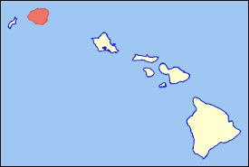
Hawaii
Hawaii is the newest of the 50 U.S. states , and is the only U.S. state made up entirely of islands. It is the northernmost island group in Polynesia, occupying most of an archipelago in the central Pacific Ocean, southwest of the continental United States, southeast of Japan, and northeast of...
listed on the National Register of Historic Places
National Register of Historic Places
The National Register of Historic Places is the United States government's official list of districts, sites, buildings, structures, and objects deemed worthy of preservation...
. A total of 327 NRHP listings appear on all but one of Hawaii's main islands (Niihau
Niihau
Niihau or Niihau is the seventh largest of the inhabited Hawaiian Islands in the U.S. state of Hawaii, having an area of . Niihau lies southwest of Kauai across the Kaulakahi Channel. Several intermittent playa lakes provide wetland habitats for the Hawaiian Coot, the Black-winged Stilt, and the...
being the exception) and the Northwestern Islands
Northwestern Hawaiian Islands
The Northwestern Hawaiian Islands or the Leeward Islands are the small islands and atolls in the Hawaiian island chain located northwest of the islands of Kauai and Niihau. They are administered by the U.S. state of Hawaii except Midway Atoll, which has temporary residential facilities and is...
, and in all of its five counties. Included are houses, schools, archeological sites, ships, shipwrecks and various other types of listings. These properties and districts are listed by island, beginning at the northwestern end of the chain.
Current listings by island and county
The following are approximate tallies of current listings by island and county. These counts are based on entries in the National Register Information Database as of April 24, 2008 and new weekly listings posted since then on the National Register of Historic Places web site, all of which list properties simply by county; they are here divided by island for the sake of easier navigation. There are frequent additions to the listings and occasional delistings, and the counts here are approximate and not official. New entries are added to the official Register on a weekly basis. Also, the counts in this table exclude boundary increase and decrease listings which modify the area covered by an existing property or district and which carry a separate National Register reference number. The number of NRHP listings on each island are documented by tables in each of the individual island lists, and the number of listings in each county is determined by adding the totals of the islands in that county. KalawaoKalawao County, Hawaii
-Demographics:As of the census of 2000, there were 147 people, 115 households, and 21 families residing in the county. The population density was 11 people per square mile . There were 172 housing units at an average density of 13 per square mile...
and Maui
Maui County, Hawaii
-National protected areas:* Haleakala National Park* Kakahaia National Wildlife Refuge* Kealia Pond National Wildlife Refuge- Demographics :As of the 2000 Census, there were 128,094 people, 43,507 households, and 29,889 families residing in the county. The population density was 110 people per...
counties are the sole exception: Kalawao County is a peninsula on Molokai
Molokai
Molokai or Molokai is an island in the Hawaiian archipelago. It is 38 by 10 miles in size with a land area of , making it the fifth largest of the main Hawaiian Islands and the 27th largest island in the United States. It lies east of Oahu across the 25-mile wide Kaiwi Channel and north of...
, which is otherwise a part of Maui County.

| Island | # of Sites | |
|---|---|---|
| 1 | Northwestern Hawaiian Islands | 2 |
| 2 | Kauai | 37 |
| 3 | Oahu National Register of Historic Places listings in Oahu This is a list of properties and districts on the Hawaiian island of Oahu that are listed on the National Register of Historic Places. Oahu is the only major island in Honolulu County. The location of the city of Honolulu, Oahu is the most populous island in the state. There are 149 properties and... |
150 |
| 4 | Molokai | 27 |
| 6 | Lanai | 2 |
| 5 | Maui | 35 |
| 7 | Kahoolawe | 1 |
| 8 | Hawaii National Register of Historic Places listings on the island of Hawaii This is a list of properties and districts on the island of Hawaii in the U.S. state of Hawaii that are listed on the National Register of Historic Places. The island is coterminous with Hawaii County, the state's only county that covers exactly one island... |
73 |
| TOTAL | 327 | |
| County | # of Sites | |
|---|---|---|
| 1 | Hawaii | 73 |
| 2 | Honolulu | 152 |
| 3 | Kalawao | 2 |
| 4 | Kauai | 37 |
| 5 | Maui | 63 |
| TOTAL | 327 | |
Northwestern Hawaiian IslandsNorthwestern Hawaiian IslandsThe Northwestern Hawaiian Islands or the Leeward Islands are the small islands and atolls in the Hawaiian island chain located northwest of the islands of Kauai and Niihau. They are administered by the U.S. state of Hawaii except Midway Atoll, which has temporary residential facilities and is...

Honolulu County, Hawaii
The City and County of Honolulu is a consolidated city–county located in the U.S. state of Hawaii. The municipality and county includes both the urban district of Honolulu and the rest of the island of Oahu, as well as several minor outlying islands, including all of the Northwestern Hawaiian...
, despite the vast distance between them and Oahu.
| Landmark name | Image | Date listed | Location | Community | Summary | |
|---|---|---|---|---|---|---|
| 1 | Necker Island Archeological District | 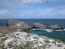 |
Address Restricted 23°34′N 164°42′W |
Necker Island | Part or all of the island | |
| 2 | Nihoa Island Archeological District | 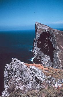 |
Address Restricted 23°3′41.076"N 161°55′31.548"W |
Nihoa Island Nihoa Nihoa , also known as Bird Island or Moku Manu, is the largest and tallest of ten islands and atolls in the uninhabited Northwestern Hawaiian Islands . The island is located at the southern end of the NWHI chain, southeast of Necker Island... |
Part or all of the island |
KauaiKauaiKauai or Kauai, known as Tauai in the ancient Kaua'i dialect, is geologically the oldest of the main Hawaiian Islands. With an area of , it is the fourth largest of the main islands in the Hawaiian archipelago, and the 21st largest island in the United States. Known also as the "Garden Isle",...
Niihau
Niihau or Niihau is the seventh largest of the inhabited Hawaiian Islands in the U.S. state of Hawaii, having an area of . Niihau lies southwest of Kauai across the Kaulakahi Channel. Several intermittent playa lakes provide wetland habitats for the Hawaiian Coot, the Black-winged Stilt, and the...
, the westernmost. Together with Niihau, it forms Kauai County
Kauai County, Hawaii
Kauai County is a county located in the U.S. state of Hawaii. It consists of the islands of Kauai, Niihau, Lehua, and Kaula, in the state of Hawaii. As of 2000 Census the population was 58,463...
.
| Landmark name | Image | Date listed | Location | Community | Summary | |
|---|---|---|---|---|---|---|
| 1 | Bishop National Bank of Hawaii | Hawaii Route 50 Hawaii Route 50 Route 50 is a road that stretches from Route 56 at the junction of Rice Street in Lihue to a point approximately 1/5 mile north of the northernmost entrance of the Pacific Missile Range Facility on the western shore of Kauai. It is the longest numbered road on the island of Kauai is named... 21°57′34"N 159°40′9"W |
Waimea Waimea, Kauai County, Hawaii Waimea is a census-designated place in Kauai County, Hawaii, United States. The population was 1,787 at the 2000 census... |
Now First Hawaiian Bank, 4525 Panako Rd., Waimea | ||
| 2 | Camp Sloggett | Southwest of Hawaii Route 550 Hawaii Route 550 Route 550 is a fourteen mile road stretching from Route 50 in Waimea to Kōkeʻe State Park on the island of Kauai.-Route description:... 22°7′36"N 159°39′11"W |
Koke'e State Park Koke'e State Park Kōkee State Park is located in northwestern Kauai in the Hawaiian Islands. It includes a museum at the marker on State Road 550, which focuses on the weather, vegetation, and bird life; a lodge which serves food and sells gifts; cabins for rent; and hiking trails... |
Now YWCA Camp | ||
| 3 | Civilian Conservation Corps Camp in Koke'e State Park | Hawaii Route 550 Hawaii Route 550 Route 550 is a fourteen mile road stretching from Route 50 in Waimea to Kōkeʻe State Park on the island of Kauai.-Route description:... at Kokee State Park Headquarters 22°7′59"N 159°39′44"W |
Koke'e State Park Koke'e State Park Kōkee State Park is located in northwestern Kauai in the Hawaiian Islands. It includes a museum at the marker on State Road 550, which focuses on the weather, vegetation, and bird life; a lodge which serves food and sells gifts; cabins for rent; and hiking trails... |
|||
| 4 | Cook Landing Site Cook Landing Site (Waimea, Hawai'i) The Cook Landing Site in Waimea on Kauai island in Hawaii, is where Captain James Cook landed at the mouth of the Waimea River on January 20, 1778... |
 |
2 miles (3.2 km) southwest of Hawaii Route 50 Hawaii Route 50 Route 50 is a road that stretches from Route 56 at the junction of Rice Street in Lihue to a point approximately 1/5 mile north of the northernmost entrance of the Pacific Missile Range Facility on the western shore of Kauai. It is the longest numbered road on the island of Kauai is named... |
Waimea Waimea, Kauai County, Hawaii Waimea is a census-designated place in Kauai County, Hawaii, United States. The population was 1,787 at the 2000 census... |
||
| 5 | Charles Gay House | Gay Rd. 21°58′26"N 159°39′46"W |
Waimea Waimea, Kauai County, Hawaii Waimea is a census-designated place in Kauai County, Hawaii, United States. The population was 1,787 at the 2000 census... |
|||
| 6 | Grove Farm Grove Farm (Lihue, Hawaii) -History:German immigrant Hermann A. Widemann started one of the first sugar plantations in Hawaii known as Grove Farm in 1854.During the American Civil War, the demand for Hawaii sugar grew, but Widemann supported the Confederate States.... |
On Hawaii Route 58 Hawaii Route 58 Route 58 is a two mile road that stretches from Route 50 in Lihue to the junction of Wapaa Road with Hawaii 51 near Nawiliwili Harbor on Kauai island.- Route description :... , about 1 miles (1.6 km) southeast of Lihue 21°58′4"N 159°22′1"W |
Lihue | Homestead of plantation owner George N. Wilcox, built 1864, converted to museum in 1978 | ||
| 7 | Grove Farm Company Locomotives | Off Hawaii Route 50 Hawaii Route 50 Route 50 is a road that stretches from Route 56 at the junction of Rice Street in Lihue to a point approximately 1/5 mile north of the northernmost entrance of the Pacific Missile Range Facility on the western shore of Kauai. It is the longest numbered road on the island of Kauai is named... 21°58′6"N 159°23′50"W |
Puhi Puhi, Hawaii Puhi is a census-designated place in Kauai County, Hawaii, United States. The population was 1,186 at the 2000 census.-Geography:Puhi is located at .... |
|||
| 8 | Gulick-Rowell House | Missionary Row (now Huakai Rd.) 21°57′41"N 159°40′19"W |
Waimea Waimea, Kauai County, Hawaii Waimea is a census-designated place in Kauai County, Hawaii, United States. The population was 1,787 at the 2000 census... |
Across from Waimea Canyon Middle School, on way to Kauai Veterans Memorial Hospital, first built 1829 by Rev. Peter Johnson Gulick Peter Johnson Gulick Peter Johnson Gulick was a missionary to the Kingdom of Hawaii and Japan. He was patriarch of a family that also carried on the tradition of missionary work, and included several scientists.-Life:... , completed by Rev. George Rowell in 1846 |
||
| 9 | Haena Archeological Complex | Beyond Ha'ena State Park Ha'ena State Park Hāena State Park is a state park located on the north shore of the Hawaiian island of Kauai. It is often referred to as the "end of the road" and marks the end point of the Kuhio Highway. The park provides access to beaches, trails, and several ancient Hawaiian sites, including sea caves estimated... at end of Hawaii Route 560 Hawaii Route 560 Route 560 or Kaua'i Belt Road-North Shore section, is a ten-mile scenic road on the northern shore of the island of Kauai in Hawaii. The entire belt road is signed as the Kuhio Highway and Hawaii Route 56 was once signed on this route before it was downgraded to become Hawaii Route 560... between high cliffs and rocky shore of Kēē Bay |
Hanalei Hanalei, Hawaii Hanalei is a census-designated place in Kauai County, Hawaii, United States. The population was 478 at the 2000 census. Hanalei means "lei making" in Hawaiian... |
Sites: (1) house of high chief Lohiau (lover of Hi'iaka Hi'iaka In Hawaiian mythology, Hiiaka is a daughter of Haumea and Kāne. She was the patron goddess of Hawaii and the hula dancers, and takes on the task of bearing the clouds - variously, those of storms and those produced by her sister's volcanos, and lived in a grove of Lehua trees which are sacred to... ); (2) Ke-ahu-a-Laka hālau hula Halau hula A hālau hula is a school in which the ancient Hawaiian dance form called hula is taught. The term comes from hālau, a workshed, and hula, the traditional dance of the Hawaiian Islands. Prior to European contact, the Hawaiian language had no word for "school," as children learned from their parents,... platform; (3) Ka-ulu-a-paoa heiau Heiau A heiau is a Hawaiian temple. Many types of heiau existed, including heiau to treat the sick , offer first fruits, offer first catch, start rain, stop rain, increase the population, ensure health of the nation, achieve success in distant voyaging, reach peace, and achieve success in war . Only the... platform |
||
| 10 | Hanalei Elementary School | 5-5161 Kuhio Hwy. 22°12′27"N 159°29′54"W |
Hanalei Hanalei, Hawaii Hanalei is a census-designated place in Kauai County, Hawaii, United States. The population was 478 at the 2000 census. Hanalei means "lei making" in Hawaiian... |
Built 1911 | ||
| 11 | Hanalei Pier Hanalei Pier Hanalei Pier is a pier built into Hanalei Bay on the northern shore of island of Kauai in the state of Hawaii.-History:The wetlands of Hanalei Bay were used to grow taro by ancient Hawaiians... |
Hanalei Bay Hanalei Bay Hanalei Bay is the largest bay on the north shore of Kauai island in Hawaii. The town of Hanalei is at the mid-point of the bay.Hanalei Bay consists of nearly two miles of beach, surrounded by mountains. In the summer, the bay offers excellent mooring for sailboats, stand up paddle boarding and... 22°13′2"N 159°30′2"W |
Hanalei Hanalei, Hawaii Hanalei is a census-designated place in Kauai County, Hawaii, United States. The population was 478 at the 2000 census. Hanalei means "lei making" in Hawaiian... |
|||
| 12 | Hanapepe Town Lot No. 18 | Hanapepe Rd. west of its junction with Ko Rd. 21°54′53"N 159°35′24"W |
Hanapepe Hanapepe, Hawaii Hanapepe is a census-designated place in Kauai County, Hawaii, United States... |
Former pool hall | ||
| 13 | Haraguchi Rice Mill | Ohiki Rd. 22°12′35"N 159°28′36"W |
Hanalei Hanalei, Hawaii Hanalei is a census-designated place in Kauai County, Hawaii, United States. The population was 478 at the 2000 census. Hanalei means "lei making" in Hawaiian... |
In Hanalei Valley, one of four former rice mills | ||
| 14 | Kaua'i Belt Road-North Shore section | Hawaii Route 560 Hawaii Route 560 Route 560 or Kaua'i Belt Road-North Shore section, is a ten-mile scenic road on the northern shore of the island of Kauai in Hawaii. The entire belt road is signed as the Kuhio Highway and Hawaii Route 56 was once signed on this route before it was downgraded to become Hawaii Route 560... 22°12′43"N 159°31′40"W |
Princeville Princeville, Hawaii Princeville is a census-designated place on the north shore of the island of Kauai in Kauai County, Hawaii, United States. The population was 1,698 at the 2000 census.-Geography:Princeville is located at .... |
All or part of Hawaii Route 560 Hawaii Route 560 Route 560 or Kaua'i Belt Road-North Shore section, is a ten-mile scenic road on the northern shore of the island of Kauai in Hawaii. The entire belt road is signed as the Kuhio Highway and Hawaii Route 56 was once signed on this route before it was downgraded to become Hawaii Route 560... |
||
| 15 | Kikiaola Kikiaola Kīkīaola is a historic irrigation ditch located near Waimea on the island of Kauai in the U.S. state of Hawaii. Also known as "Menehune Ditch" or "Peekauai Ditch," it was added to the National Register of Historic Places on November 16, 1984... |
Menehune Rd., Waimea 21°58′31"N 159°39′35"W |
Waimea Waimea, Kauai County, Hawaii Waimea is a census-designated place in Kauai County, Hawaii, United States. The population was 1,787 at the 2000 census... |
A historic ditch purportedly built by the Menehune Menehune In Hawaiian mythology, the Menehune [pronounced meh-neh-HOO-neh] are said to be a people, sometimes described as dwarfs in size, who live in the deep forests and hidden valleys of the Hawaiian Islands, far from the eyes of normal humans. Their favorite food is the maia , but they also like... |
||
| 16 | Kilauea Plantation Head Bookkeeper's House | 2421 Kolo Rd. 22°12′30"N 159°24′46"W |
Kilauea Kilauea, Hawaii Kīlauea, on the Island of Kauai, shares the name of the active volcano, Mt. Kilauea. The name literally translates to "spewing" or '"much spreading" in Hawaiian. Kilauea, the town, is a census-designated place in Kauai County, Hawaii, United States.... |
|||
| 17 | Kilauea Plantation Head Luna's House | 2457 Kolo Rd. 22°12′30"N 159°24′46"W |
Kilauea Kilauea, Hawaii Kīlauea, on the Island of Kauai, shares the name of the active volcano, Mt. Kilauea. The name literally translates to "spewing" or '"much spreading" in Hawaiian. Kilauea, the town, is a census-designated place in Kauai County, Hawaii, United States.... |
|||
| 18 | Kilauea Plantation Manager's House | 4591 Kuawa Rd. 22°12′20"N 159°24′44"W |
Kilauea Kilauea, Hawaii Kīlauea, on the Island of Kauai, shares the name of the active volcano, Mt. Kilauea. The name literally translates to "spewing" or '"much spreading" in Hawaiian. Kilauea, the town, is a census-designated place in Kauai County, Hawaii, United States.... |
|||
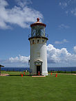
| 19 | Kilauea Point Light Station Kilauea Light Kīlauea Lighthouse is located on Kīlauea Point on the island of Kauai, Hawaii in the Kīlauea Point National Wildlife Refuge.-History:Kīlauea Point, a narrow, lava peninsula protruding from the northern shore of Kauai, was purchased from the Kīlauea Sugar Plantation Company in 1909 for one US... |
|
Kilauea Point National Wildlife Refuge Kilauea Point National Wildlife Refuge Kīlauea Point National Wildlife Refuge is a National Wildlife Refuge on the northwest coast of the island of Kauai in Hawaii.-History:Kīlauea Lighthouse was built in 1913. In 1976, the Coast Guard deactivated the lighthouse and replaced it with an automatic beacon... |
Kilauea Kilauea, Hawaii Kīlauea, on the Island of Kauai, shares the name of the active volcano, Mt. Kilauea. The name literally translates to "spewing" or '"much spreading" in Hawaiian. Kilauea, the town, is a census-designated place in Kauai County, Hawaii, United States.... |
A lighthouse located on a narrow peninsula on Kauai's northern coast | |
| 20 | Kilauea School | 2440 Kolo Rd. 22°12′39"N 159°24′44"W |
Kilauea Kilauea, Hawaii Kīlauea, on the Island of Kauai, shares the name of the active volcano, Mt. Kilauea. The name literally translates to "spewing" or '"much spreading" in Hawaiian. Kilauea, the town, is a census-designated place in Kauai County, Hawaii, United States.... |
Est. 1882 | ||
| 21 | Kong Lung Store | 2484 Keneke Street, on Kilauea Lighthouse Rd., half-mile north of Hawaii Route 56 Hawaii Route 56 Route 56, also known as Kuhio Highway, is the main highway on the north and east shore of Kauaii island.-Route description :Route 56 runs , stretching from Hawaii Route 50 at the junction of Rice Street in Lihue, Hawaii to the junction of Hawaii Route 560 in Princeville on the island of Kauaii... 22°12′55"N 159°24′35"W |
Kilauea Kilauea, Hawaii Kīlauea, on the Island of Kauai, shares the name of the active volcano, Mt. Kilauea. The name literally translates to "spewing" or '"much spreading" in Hawaiian. Kilauea, the town, is a census-designated place in Kauai County, Hawaii, United States.... |
Originally built to be the Kilauea Plantation store | ||
| 22 | Kukui Heiau | At Alakukui Point on north shore of Wailua Bay (accessible via public right-of-way between the Kauai Sands and Lae Nani Condominium) | Wailua Wailua, Hawaii Wailuā is a census-designated place in Kauai County, Hawaii, United States. The population was 2,083 at the 2000 census.-Geography:... |
On state land donated by neighboring condo developers; now landscaped, but retains facing walls and offers good view of Wailua Bay | ||
| 23 | Lihue Civic Center Historic District | Off Hawaii Route 50 Hawaii Route 50 Route 50 is a road that stretches from Route 56 at the junction of Rice Street in Lihue to a point approximately 1/5 mile north of the northernmost entrance of the Pacific Missile Range Facility on the western shore of Kauai. It is the longest numbered road on the island of Kauai is named... 21°58′47"N 159°22′11"W |
Lihue | |||
| 24 | Lihue Hongwanji Mission | North of Lihue at Hawaii Route 56 Hawaii Route 56 Route 56, also known as Kuhio Highway, is the main highway on the north and east shore of Kauaii island.-Route description :Route 56 runs , stretching from Hawaii Route 50 at the junction of Rice Street in Lihue, Hawaii to the junction of Hawaii Route 560 in Princeville on the island of Kauaii... 21°59′44"N 159°22′8"W |
Lihue | At 3-3556-A Kuhio Highway, a branch of Honpa Hongwanji Mission of Hawaii | ||
| 25 | Menehune Fishpond |  |
On the Hulēia River south of Lihue (viewable from lookout on south side of Puhi Road) 21°57′9"N 159°22′31"W |
Lihue | Also called Alekoko or Niamalu Pond, bounded by wall 900 yards long at large bend in Hulēia River Huleia National Wildlife Refuge The Hulēia National Wildlife Refuge is a National Wildlife Refuge on the island of Kauai in Hawaii. It is adjacent to the Menehune Fish Pond, a registered National Historic Landmark, on the southeast side of the island. The Hulēia Refuge is approximately of bottomlands and wooded slopes along the... |
|
| 26 | Na Pali Coast Archeological District | Address Restricted | Hanalei Hanalei, Hawaii Hanalei is a census-designated place in Kauai County, Hawaii, United States. The population was 478 at the 2000 census. Hanalei means "lei making" in Hawaiian... |
|||
| 27 | Old Sugar Mill of Koloa Old Sugar Mill of Koloa The Old Sugar Mill of Kōloa was part of the first commercially successful sugar plantation in Hawaii, which was founded in Kōloa in 1835 by Ladd & Company. This was the beginning of what would become Hawaii's largest industry. The building was designated a National Historic Landmark on December... |
Maluhia and Koloa Rds. 21°54′35"N 159°28′9"W |
Koloa Koloa, Hawaii Kōloa is a census-designated place in Kauai County, Hawaii, United States. The population was 1,942 at the 2000 census. Kōloa is often incorrectly translated as native duck, which is the correct translation for the similar-looking koloa . Kōloa has no known translation... |
The mill for Hawaii's first commercially successful sugar plantation Sugar plantations in Hawaii Sugarcane was introduced to Hawaii by its first inhabitants in approximately 600 AD and was observed by Captain Cook upon arrival in the islands in 1778. Sugar quickly turned into a big business and generated rapid population growth in the islands with 337,000 people immigrating over the span of a... |
||
| 28 | Opaekaa Road Bridge Opaekaa Road Bridge The Opaekaa Road Bridge is a steel truss bridge listed on the National Register of Historic Places located along Opaekaa Road in the Wailua Homesteads neighborhood of Kapaa, on the island of Kauai, in the state of Hawaii, United States. The one-lane bridge spans Opaekaa Stream... |
Ōpaekaa Rd. 22°3′49"N 159°22′51"W |
Kapaa Kapa'a, Hawai'i Kapaa is a census-designated place in Kauai County, Hawaii, United States. The population was 9,472 at the 2000 census.... |
First built 1890 | ||
| 29 | Pu'u'opae Bridge Pu'u'opae Bridge The Puuōpae Bridge is a one-lane, single-span, concrete-encased steel bridge across Kalama Stream located along Puuōpae Road between Kalama and Kīpapa Roads in the Wailua Homesteads area near Kapaa in Kauai, Hawaii, United States... |
Puuōpae Bridge between Kalama and Kipapa Rds. 22°4′11"N 159°22′23"W |
Kapaa Kapa'a, Hawai'i Kapaa is a census-designated place in Kauai County, Hawaii, United States. The population was 9,472 at the 2000 census.... |
One-lane, concrete-encased steel bridge on Puuōpae Rd. at Kipapa Rd. | ||
| 30 | Russian Fort Russian Fort Elizabeth Russian Fort Elizabeth is a fort on the island of Kauai in Hawaii. It was the last remaining Russian fort on the Hawaiian islands, built in the early 19th century by the Russian-American Company as the result of an alliance with High Chief Kaumualii to gain influence in Hawaii... |
 |
On Hawaii Route 50 Hawaii Route 50 Route 50 is a road that stretches from Route 56 at the junction of Rice Street in Lihue to a point approximately 1/5 mile north of the northernmost entrance of the Pacific Missile Range Facility on the western shore of Kauai. It is the longest numbered road on the island of Kauai is named... , 200 yards southwest of the bridge over the Waimea River 21°57′23"N 159°40′3"W |
Waimea Waimea, Kauai County, Hawaii Waimea is a census-designated place in Kauai County, Hawaii, United States. The population was 1,787 at the 2000 census... |
||
| 31 | Seto Building Seto Building The Seto Building at 4-1435 Kuhio Highway in Kapaa, Kauai, was earlier known as the Quality Market and then the Big Save Building. It was built in 1929 to serve as the first general food market on the island of Kauai, with the latest refrigeration methods to store a variety of fresh meat and produce... |
4-1435 Kuhio Highway 22°7′7"N 159°19′11"W |
Kapaa Kapa'a, Hawai'i Kapaa is a census-designated place in Kauai County, Hawaii, United States. The population was 9,472 at the 2000 census.... |
|||
| 32 | US Post Office-Lihue | 4441 Rice St. 21°58′46"N 159°22′19"W |
Lihue | Zipcode 96766 | ||
| 33 | Wailua Complex of Heiaus Wailua River State Park Wailua River State Park and the Wailua Complex of Heiaus, which it includes, are located on the eastern side of the Hawaiian island of Kauai. The park consists primarily of the Wailua River valley, which is the only navigable river in Hawaii. Visitors to this park can kayak, take riverboat cruises... |
At the mouth of the Wailua River Wailua River The Wailuā River is a river on the island of Kauai in the U.S. state of Hawaii. It is formed by the confluence of its North and South forks just west of Wailua and enters the Pacific Ocean at . It is the only navigable river in the Hawaiian Islands... in the Lihue District, on the eastern coast of Kauai |
Wailua Wailua, Hawaii Wailuā is a census-designated place in Kauai County, Hawaii, United States. The population was 2,083 at the 2000 census.-Geography:... |
Many ruins of old heiau Heiau A heiau is a Hawaiian temple. Many types of heiau existed, including heiau to treat the sick , offer first fruits, offer first catch, start rain, stop rain, increase the population, ensure health of the nation, achieve success in distant voyaging, reach peace, and achieve success in war . Only the... , ancient Hawaiian temples |
||
| 34 | Waioli Mission District Waioli Mission District The Waioli Mission District at Hanalei Bay, on Route 560 along the north shore of the island of Kauai, is the site of a historic mission. The first permanent missionaries to the area arrived in 1834, and the district was added to the National Register of Historic Places in 1973.-Description:Wai oli... |
Off Hawaii Route 560 Hawaii Route 560 Route 560 or Kaua'i Belt Road-North Shore section, is a ten-mile scenic road on the northern shore of the island of Kauai in Hawaii. The entire belt road is signed as the Kuhio Highway and Hawaii Route 56 was once signed on this route before it was downgraded to become Hawaii Route 560... 22°12′4"N 159°30′4"W |
Hanalei Hanalei, Hawaii Hanalei is a census-designated place in Kauai County, Hawaii, United States. The population was 478 at the 2000 census. Hanalei means "lei making" in Hawaiian... |
Established 1834; Mission Hall, built in 1841, is oldest extant church building Church Building The Church Building is located at the corner of Main and Market Streets in downtown Poughkeepsie, New York, United States, just across Market Street from the Dutchess County Court House, and north of the Bardavon Theater... on the island; was Congregational, now United Church of Christ United Church of Christ The United Church of Christ is a mainline Protestant Christian denomination primarily in the Reformed tradition but also historically influenced by Lutheranism. The Evangelical and Reformed Church and the Congregational Christian Churches united in 1957 to form the UCC... |
||
| 35 | Albert Spencer Wilcox Beach House Albert Spencer Wilcox Beach House The Albert Spencer Wilcox Beach House was a home of Albert Spencer Wilcox. Located on Weke Road in Hanalei, Hawaii, it was listed on the National Register of Historic Places in 1993. It is a "Folk Victorian"-style building. A property, including five contributing buildings and four other... |
4943 Weke Rd. 22°12′53"N 159°29′54"W |
Hanalei Hanalei, Hawaii Hanalei is a census-designated place in Kauai County, Hawaii, United States. The population was 478 at the 2000 census. Hanalei means "lei making" in Hawaiian... |
|||
| 36 | Albert Spencer Wilcox Building Albert Spencer Wilcox Building The Albert Spencer Wilcox Building, was originally a library and then converted to the Kauai Museum, which displays exhibits on the history of the island of Kauai in Hawaii.-Library:... |
4428 Rice St. 21°58′47"N 159°22′13"W |
Lihue | Designed by Hart Wood Hart Wood Hart Wood was an American architect who flourished during the "Golden Age" of Hawaiian architecture. He was one of the principal proponents of a distinctive "Hawaiian style" of architecture appropriate to the local environment and reflective of the cultural heritage of the islands... in 1922, opened as public library Public library A public library is a library that is accessible by the public and is generally funded from public sources and operated by civil servants. There are five fundamental characteristics shared by public libraries... in 1924, converted to Kauai Museum in 1970 |
||
| 37 | Yamase Building Yamase Building The Yamase Building at the corner of Moana Road and Kaumualii Highway in Waimea, Kauai, was built around 1921 by an itinerant Japanese temple architect for Seiichi Yamase, a nisei son of Japanese immigrants... |
4493 Moana Rd. 21°57′37"N 159°40′18"W |
Waimea Waimea, Kauai County, Hawaii Waimea is a census-designated place in Kauai County, Hawaii, United States. The population was 1,787 at the 2000 census... |
OahuOahuOahu or Oahu , known as "The Gathering Place", is the third largest of the Hawaiian Islands and most populous of the islands in the U.S. state of Hawaii. The state capital Honolulu is located on the southeast coast...
Honolulu County, Hawaii
The City and County of Honolulu is a consolidated city–county located in the U.S. state of Hawaii. The municipality and county includes both the urban district of Honolulu and the rest of the island of Oahu, as well as several minor outlying islands, including all of the Northwestern Hawaiian...
. The location of the city of Honolulu, Oahu is the most populous island in the state.
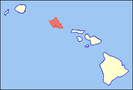
MolokaiMolokaiMolokai or Molokai is an island in the Hawaiian archipelago. It is 38 by 10 miles in size with a land area of , making it the fifth largest of the main Hawaiian Islands and the 27th largest island in the United States. It lies east of Oahu across the 25-mile wide Kaiwi Channel and north of...
Molokai is the northernmost of the islands of Maui CountyMaui County, Hawaii
-National protected areas:* Haleakala National Park* Kakahaia National Wildlife Refuge* Kealia Pond National Wildlife Refuge- Demographics :As of the 2000 Census, there were 128,094 people, 43,507 households, and 29,889 families residing in the county. The population density was 110 people per...
. Unlike every other island in the state, it is divided between two counties: Kalawao County
Kalawao County, Hawaii
-Demographics:As of the census of 2000, there were 147 people, 115 households, and 21 families residing in the county. The population density was 11 people per square mile . There were 172 housing units at an average density of 13 per square mile...
consists of the island's northern peninsula.
| Landmark name | Image | Date listed | Location | Community | Summary | |
|---|---|---|---|---|---|---|
| 1 | Archeological Site (T-10) 50-60-04-702 Archeological Sites at Kawela Archeological Sites at Kawela are a number of archeological sites at or near the settlement of Kawela on the southern coast of Molokai, the northernmost of the islands of Maui County, Hawaii. It was the site of two battles in Hawaiian history.... |
Address Restricted | Kawela | |||
| 2 | Archeological Site (T-108) 50-60-03-713 Archeological Sites at Kawela Archeological Sites at Kawela are a number of archeological sites at or near the settlement of Kawela on the southern coast of Molokai, the northernmost of the islands of Maui County, Hawaii. It was the site of two battles in Hawaiian history.... |
Address Restricted | Kawela | |||
| 3 | Archeological Site (T-111-116; T-182) 50-60-04-710 Archeological Sites at Kawela Archeological Sites at Kawela are a number of archeological sites at or near the settlement of Kawela on the southern coast of Molokai, the northernmost of the islands of Maui County, Hawaii. It was the site of two battles in Hawaiian history.... |
Address Restricted | Kawela | |||
| 4 | Archeological Site (T-12) 50-60-04-704 Archeological Sites at Kawela Archeological Sites at Kawela are a number of archeological sites at or near the settlement of Kawela on the southern coast of Molokai, the northernmost of the islands of Maui County, Hawaii. It was the site of two battles in Hawaiian history.... |
Address Restricted | Kawela | |||
| 5 | Archeological Site (T-125-6; T-181) 50-60-03-714 Archeological Sites at Kawela Archeological Sites at Kawela are a number of archeological sites at or near the settlement of Kawela on the southern coast of Molokai, the northernmost of the islands of Maui County, Hawaii. It was the site of two battles in Hawaiian history.... |
Address Restricted | Kawela | |||
| 6 | Archeological Site (T-134) 5060-03-718 Archeological Sites at Kawela Archeological Sites at Kawela are a number of archeological sites at or near the settlement of Kawela on the southern coast of Molokai, the northernmost of the islands of Maui County, Hawaii. It was the site of two battles in Hawaiian history.... |
Address Restricted | Kawela | |||
| 7 | Archeological Site (T-135-6) 50-60-03-719 Archeological Sites at Kawela Archeological Sites at Kawela are a number of archeological sites at or near the settlement of Kawela on the southern coast of Molokai, the northernmost of the islands of Maui County, Hawaii. It was the site of two battles in Hawaiian history.... |
Address Restricted | Kawela | |||
| 8 | Archeological Site (T-155, -158) 50-60-03-721 Archeological Sites at Kawela Archeological Sites at Kawela are a number of archeological sites at or near the settlement of Kawela on the southern coast of Molokai, the northernmost of the islands of Maui County, Hawaii. It was the site of two battles in Hawaiian history.... |
Address Restricted | Kawela | |||
| 9 | Archeological Site (T-165-6) 50-60-03-727 Archeological Sites at Kawela Archeological Sites at Kawela are a number of archeological sites at or near the settlement of Kawela on the southern coast of Molokai, the northernmost of the islands of Maui County, Hawaii. It was the site of two battles in Hawaiian history.... |
Address Restricted | Kawela | |||
| 10 | Archeological Site (T-19) 50-60-04-705 Archeological Sites at Kawela Archeological Sites at Kawela are a number of archeological sites at or near the settlement of Kawela on the southern coast of Molokai, the northernmost of the islands of Maui County, Hawaii. It was the site of two battles in Hawaiian history.... |
Address Restricted | Kawela | |||
| 11 | Archeological Site (T-5, T-122, T-178) 50-60-04-142 Archeological Sites at Kawela Archeological Sites at Kawela are a number of archeological sites at or near the settlement of Kawela on the southern coast of Molokai, the northernmost of the islands of Maui County, Hawaii. It was the site of two battles in Hawaiian history.... |
Address Restricted | Kawela | |||
| 12 | Archeological Site (T-57) 50-60-03-720 Archeological Sites at Kawela Archeological Sites at Kawela are a number of archeological sites at or near the settlement of Kawela on the southern coast of Molokai, the northernmost of the islands of Maui County, Hawaii. It was the site of two battles in Hawaiian history.... |
Address Restricted | Kawela | |||
| 13 | Archeological Site (T-6 complex) 50-60-04-700 Archeological Sites at Kawela Archeological Sites at Kawela are a number of archeological sites at or near the settlement of Kawela on the southern coast of Molokai, the northernmost of the islands of Maui County, Hawaii. It was the site of two battles in Hawaiian history.... |
Address Restricted . | Kawela | |||
| 14 | Archeological Site (T-76) 50-60-03-724 Archeological Sites at Kawela Archeological Sites at Kawela are a number of archeological sites at or near the settlement of Kawela on the southern coast of Molokai, the northernmost of the islands of Maui County, Hawaii. It was the site of two battles in Hawaiian history.... |
Address Restricted | Kawela | |||
| 15 | Archeological Site (T-78) 50-60-03-723 Archeological Sites at Kawela Archeological Sites at Kawela are a number of archeological sites at or near the settlement of Kawela on the southern coast of Molokai, the northernmost of the islands of Maui County, Hawaii. It was the site of two battles in Hawaiian history.... |
Address Restricted | Kawela | |||
| 16 | Archeological Site (T-79) 50-60-03-726 Archeological Sites at Kawela Archeological Sites at Kawela are a number of archeological sites at or near the settlement of Kawela on the southern coast of Molokai, the northernmost of the islands of Maui County, Hawaii. It was the site of two battles in Hawaiian history.... |
Address Restricted | Kawela | |||
| 17 | Archeological Site (T-81, -100, -101, -105, -142) 50-60-03-717 Archeological Sites at Kawela Archeological Sites at Kawela are a number of archeological sites at or near the settlement of Kawela on the southern coast of Molokai, the northernmost of the islands of Maui County, Hawaii. It was the site of two battles in Hawaiian history.... |
Address Restricted | Kawela | |||
| 18 | Archeological Site (T-88) 50-60-04-707 Archeological Sites at Kawela Archeological Sites at Kawela are a number of archeological sites at or near the settlement of Kawela on the southern coast of Molokai, the northernmost of the islands of Maui County, Hawaii. It was the site of two battles in Hawaiian history.... |
Address Restricted | Kawela | |||
| 19 | Archeological Site (T-92) 50-60-04-708 Archeological Sites at Kawela Archeological Sites at Kawela are a number of archeological sites at or near the settlement of Kawela on the southern coast of Molokai, the northernmost of the islands of Maui County, Hawaii. It was the site of two battles in Hawaiian history.... |
Address Restricted | Kawela | |||
| 20 | Archeological Site 50-60-04-140 Archeological Sites at Kawela Archeological Sites at Kawela are a number of archeological sites at or near the settlement of Kawela on the southern coast of Molokai, the northernmost of the islands of Maui County, Hawaii. It was the site of two battles in Hawaiian history.... |
Address Restricted | Kawela | |||
| 21 | Archeological Site 50-60-04-144 Archeological Sites at Kawela Archeological Sites at Kawela are a number of archeological sites at or near the settlement of Kawela on the southern coast of Molokai, the northernmost of the islands of Maui County, Hawaii. It was the site of two battles in Hawaiian history.... |
Address Restricted | Kawela | |||
| 22 | Kalaupapa National Historical Park | 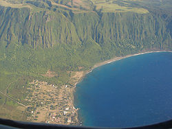 |
Molokai Molokai Molokai or Molokai is an island in the Hawaiian archipelago. It is 38 by 10 miles in size with a land area of , making it the fifth largest of the main Hawaiian Islands and the 27th largest island in the United States. It lies east of Oahu across the 25-mile wide Kaiwi Channel and north of... 21°10′40"N 156°57′36"W |
Kalaupapa Kalaupapa, Hawaii Kalaupapa is a small unincorporated community on the island of Molokai in the U.S. state of Hawaii, within Kalawao County.The village is located on the Kalaupapa peninsula at the base of the highest sea cliffs in the world, dropping about into the Pacific Ocean.- Volcanic origin :Kalaupapa... |
Park preserving sites of two isolation settlements for Hansen's disease sufferers. One of two NRHP-listed sites in Kalawao County | |
| 23 | Southwest Moloka'i Archeological District | Address Restricted | Maunaloa Maunaloa, Hawaii Maunaloa is a census-designated place in Maui County, Hawaii, United States, in the western part of the island of Molokai. The population was 230 at the 2000 census.-Geography:Maunaloa is located at .... |
|||
| 24 | U.S. Coast Guard Molokai Light | 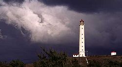 |
North of Kalaupapa 21°12′44"N 156°58′21"W |
Kalaupapa Kalaupapa, Hawaii Kalaupapa is a small unincorporated community on the island of Molokai in the U.S. state of Hawaii, within Kalawao County.The village is located on the Kalaupapa peninsula at the base of the highest sea cliffs in the world, dropping about into the Pacific Ocean.- Volcanic origin :Kalaupapa... |
A lighthouse. One of two NRHP-listed sites located in Kalawao County | |
| 25 | Hokukano-Ualapue Complex Hokukano-Ualapue Complex Hokukano-Ualapue Complex is an National Historic Landmarked pre-contact archaeological site on several properties adjacent to Hawaii Route 45 in Ualapue, on Molokaʻi. This site includes six heiaus and two fishponds. The complex is one of the most important collections of native Hawaiian sites in... |
On Hawaii Route 45 | Ualapue | One of Hawaii's most important archeological sites | ||
| 26 | Kamehameha V Wall, Archeological Site (T-20 and T-42-3) 50-60-04-706 | Address Restricted | Kawela | |||
| 27 | R.W. Meyer Sugar Mill | Hawaii Route 47 | Kalae |
LanaiLanaiLānai or Lanai is the sixth-largest of the Hawaiian Islands. It is also known as the Pineapple Island because of its past as an island-wide pineapple plantation. The only town is Lānai City, a small settlement....
Lanai is the smallest of the populated islands of Maui CountyMaui County, Hawaii
-National protected areas:* Haleakala National Park* Kakahaia National Wildlife Refuge* Kealia Pond National Wildlife Refuge- Demographics :As of the 2000 Census, there were 128,094 people, 43,507 households, and 29,889 families residing in the county. The population density was 110 people per...
, lying between the islands of Maui
Maui
The island of Maui is the second-largest of the Hawaiian Islands at and is the 17th largest island in the United States. Maui is part of the state of Hawaii and is the largest of Maui County's four islands, bigger than Lānai, Kahoolawe, and Molokai. In 2010, Maui had a population of 144,444,...
and Molokai
Molokai
Molokai or Molokai is an island in the Hawaiian archipelago. It is 38 by 10 miles in size with a land area of , making it the fifth largest of the main Hawaiian Islands and the 27th largest island in the United States. It lies east of Oahu across the 25-mile wide Kaiwi Channel and north of...
.
| Landmark name | Image | Date listed | Location | Community | Summary | |
|---|---|---|---|---|---|---|
| 1 | Kaunolu Village Site Kaunolu Village Site Kaunolū Village Site is located on the south coast of the island of Lānaʻi. This former fishing village, abandoned in the 1880s, is the largest surviving ruins of a prehistoric Hawaiian village. The archaeological site is very well-preserved and covers almost every phase of Hawaiian culture. It was... |
On southwest coast 20°44′5"N 156°57′52"W |
Lanai City | Former fishing Fishing Fishing is the activity of trying to catch wild fish. Fish are normally caught in the wild. Techniques for catching fish include hand gathering, spearing, netting, angling and trapping.... village Village A village is a clustered human settlement or community, larger than a hamlet with the population ranging from a few hundred to a few thousand , Though often located in rural areas, the term urban village is also applied to certain urban neighbourhoods, such as the West Village in Manhattan, New... , abandoned in the 1880s, that is the largest surviving ruins Ruins Ruins are the remains of human-made architecture: structures that were once complete, as time went by, have fallen into a state of partial or complete disrepair, due to lack of maintenance or deliberate acts of destruction... of a prehistoric Hawaiian Ancient Hawaii Ancient Hawaii refers to the period of Hawaiian human history preceding the unification of the Kingdom of Hawaii by Kamehameha the Great in 1810. After being first settled by Polynesian long-distance navigators sometime between AD 300–800, a unique culture developed. Diversified agroforestry and... village. |
||
| 2 | Pu'upehe Platform Pu'upehe Platform Puupehe Platform, also known Puu Pehe and in tourist literature as Sweetheart Rock, is a triangular sea stack 150 feet off the peninsula separating Mānele Bay and Hulopoe Bay on the island of Lānai, Hawaii.... (50La19) |
Between Mānele Bay and Hulopoe Bay 20°44′2"N 156°53′24"W |
Lanai City | Also known as Sweetheart Rock |
MauiMauiThe island of Maui is the second-largest of the Hawaiian Islands at and is the 17th largest island in the United States. Maui is part of the state of Hawaii and is the largest of Maui County's four islands, bigger than Lānai, Kahoolawe, and Molokai. In 2010, Maui had a population of 144,444,...
Maui is the largest and the easternmost island of Maui CountyMaui County, Hawaii
-National protected areas:* Haleakala National Park* Kakahaia National Wildlife Refuge* Kealia Pond National Wildlife Refuge- Demographics :As of the 2000 Census, there were 128,094 people, 43,507 households, and 29,889 families residing in the county. The population density was 110 people per...
.
| Landmark name | Image | Date listed | Location | Community | Summary | |
|---|---|---|---|---|---|---|
| 1 | Henry Perrine Baldwin High School | Junction of Lower Main St. and Kaahumanu Ave. 20°53′45"N 156°29′38"W |
Wailuku Wailuku, Hawaii Wailuku is a census-designated place in Maui County, Hawaii, United States. The population was 12,296 at the 2000 census. It is the county seat of Maui County.Wailuku is located just west of Kahului, at the mouth of the Īao Valley... |
|||
| 2 | Bank of Hawaii—Haiku Branch | 771 Haiku Rd. 20°59′3"N 156°19′29"W |
Haikū Haiku, Hawaii Haiku is an unincorporated community in Maui County on the island of Maui in the state of Hawaii. For United States Census purposes, it is part of the Haiku-Pauwela, Hawaii census-designated place, which also includes Pauwela.... |
Built 1931 to serve as bank and post office for bustling Haikū; restored in 1998; now Consuelo's Catering | ||
| 3 | Chee Kung Tong Society Building Chee Kung Tong Society Building The Chee Kung Tong Society Hall was a former Chinese society hall located on 2151 Vineyard Sreet in Wailuku, Maui. Built to provide services to single immigrant Chinese males, mostly working for the sugarcane plantations, it provided religious and political help, in addition to mutual aid.... |
2151 Vineyard St. 20°53′36"N 156°30′29"W |
Wailuku Wailuku, Hawaii Wailuku is a census-designated place in Maui County, Hawaii, United States. The population was 12,296 at the 2000 census. It is the county seat of Maui County.Wailuku is located just west of Kahului, at the mouth of the Īao Valley... |
Part of the Chinese Tong Houses of Maui Island TR #82000173. Collapsed in 1996; only gate and foundation remain. | ||
| 4 | Crater Historic District Crater Historic District The Crater Historic District encompasses National Park Service structures within Haleakala National Park. The buildings include utility structures, employee housing, administration facilities and visitor services facilities. Most were built by the Civilian Conservation Corps to standard Park... |
 |
Address Restricted | Kahului | ||
| 5 | Frank and Theresa Gomes House | 32 Pakani Place 20°50′58"N 156°19′3"W |
Makawao Makawao, Hawaii Makawao is a census-designated place in Maui County, Hawaii, United States. The population was 6,327 at the 2000 census. Located in the rural northeast slope of Haleakala on East Maui, the community is known for being the hub of the "Upcountry", a part of the island dominated by mostly... |
|||
| 6 | Haiku Mill Haiku Mill The Haikū Sugar Mill was a processing factory for sugarcane from 1861 to 1879 on the island of Maui in Hawaii.-History:The northeastern coast of Maui had a small village named Hai kū which literally means "sharp break" in the Hawaiian language.... |
Haiku Rd. 20°55′49"N 156°19′58"W |
Haikū Haiku, Hawaii Haiku is an unincorporated community in Maui County on the island of Maui in the state of Hawaii. For United States Census purposes, it is part of the Haiku-Pauwela, Hawaii census-designated place, which also includes Pauwela.... |
|||
| 7 | Hale Pai Lahainaluna High School Lahainaluna High School is a grade 9-12 school located in Lahaina , Hawaii. It is the oldest post-secondary school west of the Mississippi River. It was founded in 1831 as a Protestant missionary school, originally named Lahainaluna Seminary... |
Lahainaluna High School Lahainaluna High School Lahainaluna High School is a grade 9-12 school located in Lahaina , Hawaii. It is the oldest post-secondary school west of the Mississippi River. It was founded in 1831 as a Protestant missionary school, originally named Lahainaluna Seminary... 20°53′40"N 156°39′45"W |
Lahaina | |||
| 8 | Halekii-Pihana Heiau Haleki'i-Pihana Heiau State Monument Haleki'i-Pihana Heiau State Monument is a park containing two important luakini heiau on a high ridge near the mouth of Iao Stream in Wailuku, Maui... |
Hea Pl. off Kuhio Pl. from Waiehu Beach Rd. 20°54′30"N 156°29′42"W |
Wailuku Wailuku, Hawaii Wailuku is a census-designated place in Maui County, Hawaii, United States. The population was 12,296 at the 2000 census. It is the county seat of Maui County.Wailuku is located just west of Kahului, at the mouth of the Īao Valley... |
|||
| 9 | Hana Belt Road Hana Highway The Hāna Highway is a long stretch of Hawaii State Routes 36 and 360 which connects Kahului with the town of Hāna in east Maui. On the east after Kalepa bridge, Hana Highway continues to Kīpahulu as Route 31 , the first section of which is unofficially considered to be part of Hāna Highway... |
Hana Highway (Hawaii Route 360) and Pi'ilani Highway (Hawaii Route 31) 20°53′52"N 156°13′20"W |
Makawao Makawao, Hawaii Makawao is a census-designated place in Maui County, Hawaii, United States. The population was 6,327 at the 2000 census. Located in the rural northeast slope of Haleakala on East Maui, the community is known for being the hub of the "Upcountry", a part of the island dominated by mostly... |
|||
| 10 | Hana District Police Station and Courthouse | Uakea Rd. 20°45′44"N 155°59′21"W |
Hana | |||
| 11 | Hardy House | 808 Makawao Ave. 20°51′6"N 156°19′25"W |
Makawao Makawao, Hawaii Makawao is a census-designated place in Maui County, Hawaii, United States. The population was 6,327 at the 2000 census. Located in the rural northeast slope of Haleakala on East Maui, the community is known for being the hub of the "Upcountry", a part of the island dominated by mostly... |
Built in 1897 for Makawao School principal Frederick Hardy (d. 1920) & wife Lillian, who sold the house & 20 acres (80,937.2 m²) lot in 1920. Ernest and Alene Rezents bought the house in 1961 and restored what is now locally known as the Rezents House. | ||
| 12 | Holy Ghost Catholic Church Holy Ghost Catholic Church (Kula, Hawaii) Holy Ghost Catholic Church, also known as Holy Ghost Mission, is an historic octagon-shaped Roman Catholic church building located at 4300 Lower Kula Road in Waiakoa in the Kula district. It was designed by Father James Beissel and built by his parishioners who were Portuguese from the Azores and... |
4300 Lower Kula Rd. 20°46′4"N 156°20′22"W |
Kula Kula, Hawaii Kula is a district of Maui, Hawaii that stretches across the "up-country", the western-facing slopes of Haleakalā, from Makawao to Ulupalakua. Most of the residential areas lie between about 500 to 1,100 m in elevation... |
|||
| 13 | Honokalani Village | Address Restricted | Hana | |||
| 14 | Iao Theater Iao Theater The Iao Theater is a Spanish Mission style theater opened in 1928, in the city of Wailuku, Maui Hawaii. It was originally both a movie and vaudeville house, until it fell into disrepair in the 1980s. Facing possible demolition, in 1994, it was listed on the State of Hawaii's Register of Historic... |
68 N. Market St. 20°53′37"N 156°30′17"W |
Wailuku Wailuku, Hawaii Wailuku is a census-designated place in Maui County, Hawaii, United States. The population was 12,296 at the 2000 census. It is the county seat of Maui County.Wailuku is located just west of Kahului, at the mouth of the Īao Valley... |
|||
| 15 | Ka'ahumanu Avenue-Naniloa Drive Overpass | 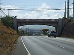 |
Naniloa Dr. at Kaahumanu Ave. 20°53′19.356"N 156°29′45.672"W |
Wailuku Wailuku, Hawaii Wailuku is a census-designated place in Maui County, Hawaii, United States. The population was 12,296 at the 2000 census. It is the county seat of Maui County.Wailuku is located just west of Kahului, at the mouth of the Īao Valley... |
||
| 16 | Ka'ahumanu Church Ka'ahumanu Church Kaahumanu Church is a Church in Wailuku, Maui Hawaii. Upon visiting a religious service in Wailuku in 1832 by Jonathan Smith Green, Queen Ka'ahumanu requested that a more permanent church structure be named for her, but her request was not honored until 1876 when the current structure was built by... |
S. High St. 20°53′49"N 156°30′1"W |
Wailuku Wailuku, Hawaii Wailuku is a census-designated place in Maui County, Hawaii, United States. The population was 12,296 at the 2000 census. It is the county seat of Maui County.Wailuku is located just west of Kahului, at the mouth of the Īao Valley... |
Est. 1876 | ||
| 17 | Kalepolepo Fishpond Kalepolepo Fishpond -External links:**... |
S. Kihei Rd., south of its junction with Hawaii Route 31 in Kalepolepo County Park 20°46′0"N 156°27′45"W |
Kihei Kihei, Hawaii Kīhei is a census-designated place in Maui County, Hawaii, United States. The population was 16,749 at the 2000 census.-Geography:Kīhei is located at .... |
|||
| 18 | Kaupo School | Government Rd. 20°38′28"N 156°7′31"W |
Kaupo Kaupo, Hawaii Kaupo is one of the districts of ancient Hawaii of Maui island in Hawaii. Kaupo is a very remote and sparsely populated sustainable ranching community.- Location :... |
|||
| 19 | Keanae School | Hana Highway 20°51′21"N 156°8′29"W |
Keanae Keanae, Hawaii Keanae is an unincorporated town in Maui County on the island of Maui in the U.S. state of Hawaii.Ke‘anae is a peninsula known best for being one of Hawaii‘s major taro farm growing regions.Keanae shares the zip code of 96708 with Ha‘iku.... |
|||
| 20 | Ket Hing Society Building | Cross Rd. 20°42′35"N 156°21′11"W |
Kula Kula, Hawaii Kula is a district of Maui, Hawaii that stretches across the "up-country", the western-facing slopes of Haleakalā, from Makawao to Ulupalakua. Most of the residential areas lie between about 500 to 1,100 m in elevation... |
Part of the Chinese Tong Houses of Maui Island TR #82000173. | ||
| 21 | King Kamehameha III's Royal Residential Complex | Junction of Front and Shaw Sts., Malu'ulu o Lele and Kamehameha Iki Parks 20°52′24"N 156°40′39"W |
Lahaina | |||
| 22 | Lahaina Historic District Lahaina Historic District Lahaina Historic District is a historic district in Lahaina, Hawaii, on the west side of the island of Maui.It was declared a National Historic Landmark in 1962. At that time it was described: -Buildings:It includes 9 contributing buildings.... |
Western side of Maui on Hawaii Route 30 Honoapiilani Highway The Honoapiilani Highway is a road on West Maui, Hawaii. It begins in downtown Wailuku, extending south through Waikapu and Maalaea. Following terrain of the island it circumvents the West side of West Maui connecting Olowalu, Launiupuko, Lahaina, Kahana, through the regions of Kapalua and... 20°52′14"N 156°41′3"W |
Lahaina | |||
| 23 | Loaloa Heiau Loaloa Heiau Loaloa Heiau is located in Kaupo on Maui. This is one of the few remaining intact examples of a large luakini heiau . Once the center of an important cultural complex around Kaupo, oral tradition attributes the construction of the temple at about 1730 AD to Kekaulike, King of Maui, who lived at... |
Southeastern coast of Maui, on Hawaii Route 31, about 0.25 mile (0.402335 km) north of Kaupo 20°38′41"N 156°7′26"W |
Kaupo Kaupo, Hawaii Kaupo is one of the districts of ancient Hawaii of Maui island in Hawaii. Kaupo is a very remote and sparsely populated sustainable ranching community.- Location :... |
|||
| 24 | Makawao Union Church Makawao Union Church Makawao Union Church is a church near Makawao on the Hawaiian island of Maui. It was founded by New England missionary Jonathan Smith Green during the Kingdom of Hawaii. The third historic structure used by the congregation was designed by noted local architect C.W. Dickey and dedicated in 1917 as... |
1445 Baldwin Ave. 20°53′32"N 156°21′3"W |
Paia Paia, Hawaii Pāia is a census-designated place in Maui County, Hawaii, on the northern coast of the island of Maui. The population was 2,499 at the 2000 census. Pāia is home to several restaurants, art galleries, surf shops and other tourist-oriented businesses. One business, Charley's, is frequented by... |
1916 stone church designed by C. W. Dickey Charles William Dickey Charles William “C.W.” Dickey was an American architect famous for developing a distinctive style of Hawaiian architecture... |
||
| 25 | Maui Jinsha Mission | 472 Lipo St. 20°54′29"N 156°29′16"W |
Wailuku Wailuku, Hawaii Wailuku is a census-designated place in Maui County, Hawaii, United States. The population was 12,296 at the 2000 census. It is the county seat of Maui County.Wailuku is located just west of Kahului, at the mouth of the Īao Valley... |
est. 1915, architect Ichitaro Takata | ||
| 26 | Old Bailey House Bailey House Museum The Bailey House Museum, also known as Old Bailey House, is a museum of Hawaiian history located in Wailuku, Hawaii, on the island of Maui, owned and operated by the Maui Historical Society.-The building:... |
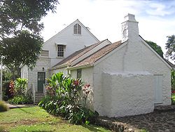 |
Iao Valley Rd. 20°53′27"N 156°30′37"W |
Wailuku Wailuku, Hawaii Wailuku is a census-designated place in Maui County, Hawaii, United States. The population was 12,296 at the 2000 census. It is the county seat of Maui County.Wailuku is located just west of Kahului, at the mouth of the Īao Valley... |
||
| 27 | Paia School | 955 Baldwin Ave. 20°54′11"N 156°21′24"W |
Pāia Paia, Hawaii Pāia is a census-designated place in Maui County, Hawaii, on the northern coast of the island of Maui. The population was 2,499 at the 2000 census. Pāia is home to several restaurants, art galleries, surf shops and other tourist-oriented businesses. One business, Charley's, is frequented by... |
Founded in 1881 as Maui's first all English-speaking school. First principal William Cross refused to learn Hawaiian. 1909 building burned down in 1963. Current main building dates from 1926. Became site of Maui's first public school Hawaiian-immersion program in 1988. | ||
| 28 | Piilanihale Heiau Kahanu Garden Kahanu Garden is a botanical garden located on the Hāna Highway near Hāna, Maui, Hawaii. It is one of five gardens of the non-profit National Tropical Botanical Garden, the others being McBryde, Allerton, and Limahuli Garden and Preserve on Kauai, and The Kampong in Florida.The garden was... |
 |
4 miles (6.4 km) north of Hana, at the mouth of Honomāele Gulch near Kalahu Point 20°47′57"N 156°2′18"W |
Hana | Within Kahanu Garden Kahanu Garden Kahanu Garden is a botanical garden located on the Hāna Highway near Hāna, Maui, Hawaii. It is one of five gardens of the non-profit National Tropical Botanical Garden, the others being McBryde, Allerton, and Limahuli Garden and Preserve on Kauai, and The Kampong in Florida.The garden was... |
|
| 29 | Puunene School Puunene School The Puunēnē School, also known as Puunene School, is a historic school building in the community of Puunēnē in the central part of Maui, Hawaii, United States. Built in 1922 by the Hawaiian Commercial and Sugar Company , which ran the community, it was erected on of land donated by the company in... |
East Camp 5 Rd. off Old Puunene Ave. 20°51′44"N 156°26′56"W |
Punēnē | 1922 school building near sugar mill | ||
| 30 | Wai'ale Drive Bridge | 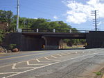 |
Ka'ahumanu Ave., 0.1 mile (0.160934 km) east of Kinipopo St. 20°53′39"N 156°30′6"W |
Wailuku Wailuku, Hawaii Wailuku is a census-designated place in Maui County, Hawaii, United States. The population was 12,296 at the 2000 census. It is the county seat of Maui County.Wailuku is located just west of Kahului, at the mouth of the Īao Valley... |
||
| 31 | Waihee Church | Kahekili Highway 20°56′6"N 156°30′54"W |
Waihee Waihee, Hawaii Waihee, Hawaii is an unincorporated town in Maui County on the island of Maui in the state of Hawaii.... |
est. 1828 | ||
| 32 | Wailuku Civic Center Historic District Wailuku Civic Center Historic District The Wailuku Civic Center Historic District is a group of four historic buildings and one non-contributing property in Wailuku, Maui Hawaii that currently house the governmental offices of both the County of Maui and the State of Hawaii. The historic buildings were built during a time span from 1901... |
S. High St. between Wells and Kaohu Sts. 20°53′25"N 156°30′26"W |
Wailuku Wailuku, Hawaii Wailuku is a census-designated place in Maui County, Hawaii, United States. The population was 12,296 at the 2000 census. It is the county seat of Maui County.Wailuku is located just west of Kahului, at the mouth of the Īao Valley... |
Contributing properties: Old Courthouse (1907, Kerr), Old Police Station (1925, D'Esmond), Wailuku Library (1928, Dickey Charles William Dickey Charles William “C.W.” Dickey was an American architect famous for developing a distinctive style of Hawaiian architecture... ), Territorial Office Building (1931, Dickey Charles William Dickey Charles William “C.W.” Dickey was an American architect famous for developing a distinctive style of Hawaiian architecture... ) |
||
| 33 | Wailuku School Wailuku School At the time Wailuku School was dedicated in May 1904 , it was described as "the handsomest school building on the island or perhaps the country." Designed by a one of the Territory of Hawaii's most prominent architects, C.W. Dickey At the time Wailuku School was dedicated in May 1904 (as Wailuku... |
355 S. High St. 20°53′17"N 156°30′29"W |
Wailuku Wailuku, Hawaii Wailuku is a census-designated place in Maui County, Hawaii, United States. The population was 12,296 at the 2000 census. It is the county seat of Maui County.Wailuku is located just west of Kahului, at the mouth of the Īao Valley... |
est. 1904, architect C. W. Dickey Charles William Dickey Charles William “C.W.” Dickey was an American architect famous for developing a distinctive style of Hawaiian architecture... |
||
| 34 | Wananalua Congregational Church Wananalua Congregational Church The Wananalua Congregational Church is a historic 19th-century building on the remote coast of Maui in Hawaii.-History:Wānanalua was the name of a traditional land division on the eastern coast of the island of Maui.... |
Hana Highway and Haouli St. 20°45′27"N 155°59′21"W |
Hana | |||
| 35 | Wo Hing Society Building Wo Hing Society Hall The Wo Hing Society Hall is a building located at 858 Front Street in the Lahaina Historic District in Lahaina, Hawaii. Built around 1912, it served the growing Chinese population centered in Lahaina, primarily those working in the sugar cane industry as a social and fraternal hall for the Wo Hing... |
 |
848 Front St. 20°52′52"N 156°40′59"W |
Lahaina | In the Lahaina Historic District Lahaina Historic District Lahaina Historic District is a historic district in Lahaina, Hawaii, on the west side of the island of Maui.It was declared a National Historic Landmark in 1962. At that time it was described: -Buildings:It includes 9 contributing buildings.... ; Part of the Chinese Tong Houses of Maui Island TR #82000173. |
KahoolaweKahoolaweKahoolawe is the smallest of the eight main volcanic islands in the Hawaiian Islands. Kahoolawe is located about seven miles southwest of Maui and also southeast of Lanai, and it is long by wide, with a total land area of . The highest point on Kahoolawe is the crater of Lua Makika at the...
Maui County, Hawaii
-National protected areas:* Haleakala National Park* Kakahaia National Wildlife Refuge* Kealia Pond National Wildlife Refuge- Demographics :As of the 2000 Census, there were 128,094 people, 43,507 households, and 29,889 families residing in the county. The population density was 110 people per...
. Alone among the state's major islands, it is uninhabited.
|}
Island of HawaiiHawaii (island)The Island of Hawaii, also called the Big Island or Hawaii Island , is a volcanic island in the North Pacific Ocean...
.svg.png)
The government of the island of Hawaii is Hawaii County
Hawaii County, Hawaii
Hawaii County is a county located in the U.S. state of Hawaii in the Hawaiian Islands. It is coterminous with the Island of Hawaii, often called the "Big Island" to distinguish it from the state as a whole. As of the 2010 Census the population was 185,079. The county seat is Hilo. There are no...
, the only county that covers exactly one island, the largest in area in the state.
There are 67 properties and districts on the island, including 10 historic districts
Historic district (United States)
In the United States, a historic district is a group of buildings, properties, or sites that have been designated by one of several entities on different levels as historically or architecturally significant. Buildings, structures, objects and sites within a historic district are normally divided...
s, 6 National Historic Landmark
National Historic Landmark
A National Historic Landmark is a building, site, structure, object, or district, that is officially recognized by the United States government for its historical significance...
s, and one which is a National Historic Landmark District.
External links
- Historic Hawaii Foundation
- Inventory of Historic Properties on official Hawaii State web site