

List of Pennsylvania state historical markers in Fayette County
Encyclopedia

This is intended to be a complete list of the official state historical markers placed in Fayette County, Pennsylvania
Fayette County, Pennsylvania
Fayette County is a county located in the U.S. state of Pennsylvania. As of the2010 census, the population was 136,606. The county is part of the Pittsburgh Metropolitan Statistical Area....
by the Pennsylvania Historical and Museum Commission
Pennsylvania Historical and Museum Commission
The Pennsylvania Historical and Museum Commission is the governmental agency of the Commonwealth of Pennsylvania responsible for the collection, conservation and interpretation of Pennsylvania's historic heritage...
(PHMC). The locations of the historical markers, as well as the latitude and longitude coordinates as provided by the PHMC's database, are included below when available. There are 49 historical markers located in Fayette County.
Historical markers
| Marker title | Image | Date dedicated | Location | Marker type | Topics |
|---|---|---|---|---|---|
| Albert Gallatin Albert Gallatin Abraham Alfonse Albert Gallatin was a Swiss-American ethnologist, linguist, politician, diplomat, congressman, and the longest-serving United States Secretary of the Treasury. In 1831, he founded the University of the City of New York... |
 |
Junction U.S. 119 & Pa. 166 N of Point Marion (Missing) °N °W |
Roadside | Government & Politics, Government & Politics 18th Century | |
| Alliance Furnace | SR 1002, about 6 miles NW of PA 819, Perryopolis °N °W |
Roadside | Business & Industry, Furnaces, Iron, Military, Native American | ||
| Alliance Furnace | Pa. 819, 1 mile N of Dawson °N °W |
Roadside | Business & Industry, Furnaces, Iron, Military, Native American | ||
| Benjamin Wells | Route 119 at N. 7th St., Connellsville 40.01847°N 79.59966°W |
City | Government & Politics, Government & Politics 18th Century, Military, Whiskey Rebellion | ||
| Birthplace of John Alfred Brashear (1840-1920) - PLAQUE John Brashear Dr. John Alfred Brashear was an American astronomer and instrument builder.- Life and work :Brashear was born in Brownsville, Pennsylvania, a town 35 miles south of Pittsburgh along the Monongahela River. His father, Basil Brown Brashear, was a saddler, and his mother, Julia Smith Brashear, was a... |
On home of Jesse Coldren, Front St., Brownsville °N °W |
Plaque | Medicine & Science, Professions & Vocations | ||
| Boatbuilding Center/Steamboat Enterprise Enterprise (1814) The Enterprise, or Enterprize, demonstrated for the first time by her epic 2,200-mile voyage from New Orleans to Pittsburgh that steamboat commerce was practical on America's western rivers.-Early days:... |
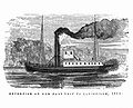 |
Dunlap's Creek Park, Bank Street, Brownsville °N °W |
Roadside | Business & Industry, Transportation | |
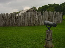
| Braddock Park Fort Necessity National Battlefield Fort Necessity National Battlefield is a National Battlefield Site in Fayette County, Pennsylvania, United States, which preserves elements of the Battle of Fort Necessity... |
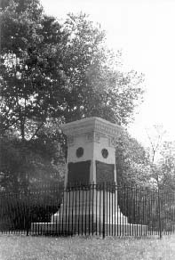 |
U.S. 40, 2.5 miles NW of Farmington 39.832°N 76.6008°W |
Roadside | French & Indian War, Military, Roads | |
| Braddock Road (Dunbar's Camp) | Jumonville Rd. (SR 2021), ~3 mi N of Rt. 40, Jumonville 39.88237°N 79.64622°W |
Roadside | French & Indian War, Military, Roads | ||
| Braddock Road (Rock Fort Camp) | US 40 at Jumonville Rd. (SR 2021), across from Summit Inn & Restaurant, Summit 39.84992°N 79.65705°W |
Roadside | French & Indian War, George Washington, Military, Native American, Roads | ||
| Braddock Road (Stewart's Crossing) | U.S. 119, .2 mile S of Connellsville 40.00055°N 79.60515°W |
Roadside | Forts, French & Indian War, Military, Roads | ||
| Braddock Road (Twelve Springs Camp) | U.S. 40, 3.5 miles SE of Farmington 39.77768°N 79.50087°W |
Roadside | American Revolution, Forts, Military, Roads, Transportation | ||
| Brashear House | 6th & Union Sts. (old U.S. 40), Brownsville °N °W |
Roadside | Buildings, Business & Industry, Education, Houses & Homesteads, Professions & Vocations, Inns & Taverns | ||
| Brownsville Brownsville, Pennsylvania Brownsville is a borough in Fayette County, Pennsylvania, United States, officially founded in 1785 located 35 miles south of Pittsburgh along the Monongahela River... |
 |
Off U.S. 40 at Brownsville °N °W |
Roadside | Cities & Towns, Forts, Military, Paths & Trails, Roads | |
| Coke Ovens | Pa. 51 just W of Perryopolis Perryopolis, Pennsylvania Perryopolis is a borough in Fayette County, Pennsylvania, United States. The population was 1,764 at the 2000 census.-History:George Washington purchased here when land first became available. He visited in 1770 and said, "as fine a land as I have ever seen, a great deal of rich meadow; it is well... °N °W |
Roadside | Business & Industry, Coal, Iron, Steel | ||
| Col. William Crawford William Crawford (soldier) William Crawford was an American soldier and surveyor who worked as a western land agent for George Washington. Crawford fought in the French and Indian War and the American Revolutionary War... |
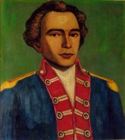 |
n/a | US 119 at N 7th St., .2 mile S of Connellsville 40.01908°N 79.5994°W |
Roadside | American Revolution, French & Indian War, George Washington, Military, Native American |
| Colonel William Crawford - PLAQUE William Crawford (soldier) William Crawford was an American soldier and surveyor who worked as a western land agent for George Washington. Crawford fought in the French and Indian War and the American Revolutionary War... |
S. Pittsburgh St. near Wills Rd., Connellsville °N °W |
Plaque | American Revolution, George Washington, Military | ||
| Connellsville Coke Region Connellsville coalfield The Connellsville Coalfield is located in Fayette County and Westmoreland County, Pennsylvania, between the city of Latrobe and the small borough of Smithfield, and is sometimes known as the Connellsville Coke Field. This is because the section of the Pittsburgh coal seam here was famous as one of... |
US Rt. 119S, near entrance to PSU Fayette, Eberly Campus, Uniontown Uniontown, Pennsylvania Uniontown is a city in Fayette County, Pennsylvania, southeast of Pittsburgh and part of the Pittsburgh Metro Area. Population in 1900, 7,344; in 1910, 13,344; in 1920, 15,692; and in 1940, 21,819. The population was 10,372 at the 2010 census... °N °W |
Roadside | Business & Industry, Coal, Iron, Labor, Steel | ||
| Dunbar's Camp | U.S. 40 approximately 6 miles SE of Uniontown, at Summit (Missing) °N °W |
City | French & Indian War, Military | ||
| Dunlap's Creek Bridge Dunlap's Creek Bridge Dunlap's Creek Bridge was the first cast iron, metal arch bridge in the United States. It was designed by Richard Delafield and built by the United States Army Corps of Engineers. Constructed from 1836 to 1839 on the National Road in Brownsville, Pennsylvania, it remains in use today... |
 |
At bridge, Market Street, Brownsville °N °W |
Roadside | Bridges, Roads, Transportation | |
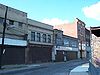
| Edwin S. Porter | 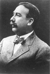 |
Pittsburgh St. & Fairview Ave., Connellsville 40.01645°N 79.58895°W |
City | Business & Industry, Motion Pictures & Television, Professions & Vocations | |
| Fallingwater Fallingwater Fallingwater or Kaufmann Residence is a house designed by architect Frank Lloyd Wright in 1935 in rural southwestern Pennsylvania, 50 miles southeast of Pittsburgh... |
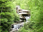 |
Route 381 at the junction to the access road to Fallingwater 39.89938°N 79.46563°W |
Roadside | Buildings, Houses & Homesteads, Professions & Vocations | |
| Fayette County Fayette County, Pennsylvania Fayette County is a county located in the U.S. state of Pennsylvania. As of the2010 census, the population was 136,606. The county is part of the Pittsburgh Metropolitan Statistical Area.... |
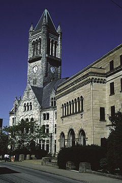 |
County Courthouse, Main St., Uniontown °N °W |
City | Forts, French & Indian War, Government & Politics, Government & Politics 18th Century, Roads | |
| Fort Gaddis Fort Gaddis Fort Gaddis is the oldest known building in Fayette County, Pennsylvania and the second oldest log cabin in Western Pennsylvania. It is located 300 yards east of old U.S. Route 119, near the Route 857 intersection; South Union Township, Fayette County, Pennsylvania... |
SR 3019 (old U.S. 119), 2 miles S of Uniontown 39.86778°N 79.7442°W |
Roadside | American Revolution, Forts, Military, Native American, Paths & Trails | ||
| Fort Mason | Pa. 166 at Masontown Masontown, Pennsylvania Masontown is a borough in Fayette County, Pennsylvania, United States. It is part of the Pittsburgh Metro Area. The population was 3,611 at the 2000 census. The town is served by the Albert Gallatin Area School District... °N °W |
Roadside | American Revolution, Forts, Military | ||
| Fort Necessity Fort Necessity National Battlefield Fort Necessity National Battlefield is a National Battlefield Site in Fayette County, Pennsylvania, United States, which preserves elements of the Battle of Fort Necessity... |
 |
U.S. 40, 1 mile NW of Farmington (Missing) °N °W |
City | Forts, French & Indian War, George Washington, Military | |
| Fort Necessity - PLAQUE | US 40, Mount Washington, 1 mile NW of Farmington °N °W |
Plaque | Forts, French & Indian War, George Washington, Military | ||
| George C. Marshall George Marshall George Catlett Marshall was an American military leader, Chief of Staff of the Army, Secretary of State, and the third Secretary of Defense... |
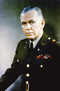 |
142 W. Main St. (U.S. 40), Uniontown °N °W |
City | Government & Politics, Government & Politics 20th Century, Military, Military Post-Civil War | |
| George Washington George Washington George Washington was the dominant military and political leader of the new United States of America from 1775 to 1799. He led the American victory over Great Britain in the American Revolutionary War as commander-in-chief of the Continental Army from 1775 to 1783, and presided over the writing of... |
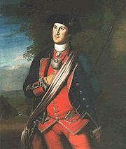 |
Pa. 51 in Perryopolis (Missing) °N °W |
Roadside | George Washington, Government & Politics, Government & Politics 18th Century | |
| Gist's Plantation | n/a | US 119, 4.5 miles SW of Connellsville 39.95499°N 79.65162°W |
City | Forts, French & Indian War, George Washington, Military | |
| James Finley (1756-1828) James Finley (engineer) James Finley , aka Judge James Finley, is widely recognized as the first designer and builder of the modern suspension bridge.Born in Maryland, Finley moved to a farm in Fayette County, Pennsylvania, near Uniontown... |
Uniontown Public Library, 24 Jefferson St., Uniontown °N °W |
Roadside | Bridges, Government & Politics, Professions & Vocations | ||
| Jumonville Defeat Battle of Jumonville Glen The Battle of Jumonville Glen, also known as the Jumonville affair, was the opening battle of the French and Indian War fought on May 28, 1754 near what is present-day Uniontown in Fayette County, Pennsylvania... |
 |
U.S. 40 approximately 6 miles SE of Uniontown at Summit (Missing) °N °W |
City | French & Indian War, George Washington, Military | |
| Meason House Isaac Meason House Isaac Meason House is a house in Mount Braddock, Pennsylvania.It was declared a National Historic Landmark in 1990.-External links:**** at the Historic American Buildings Survey... |
U.S. 119 4.5 miles SW of Connellsville 39.95405°N 79.65198°W |
Roadside | Buildings, Business & Industry, Iron, Mansions & Manors, Mills | ||
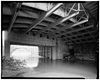
| Mount Washington Tavern | 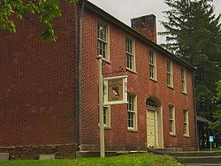 |
U.S. 40, 1.2 miles NW of Farmington °N °W |
Roadside | Buildings, Business & Industry, George Washington, Roads, Inns & Taverns | |
| National Road National Road The National Road or Cumberland Road was the first major improved highway in the United States to be built by the federal government. Construction began heading west in 1811 at Cumberland, Maryland, on the Potomac River. It crossed the Allegheny Mountains and southwestern Pennsylvania, reaching... |
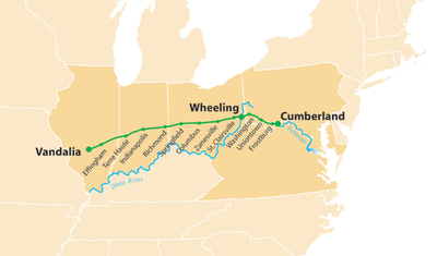 |
U.S. 40, 1.7 miles NW of Farmington 39.8244°N 76.5935°W |
Roadside | Government & Politics, Roads, Transportation | |
| National Road National Road The National Road or Cumberland Road was the first major improved highway in the United States to be built by the federal government. Construction began heading west in 1811 at Cumberland, Maryland, on the Potomac River. It crossed the Allegheny Mountains and southwestern Pennsylvania, reaching... |
U.S. 40 NW of Brier Hill °N °W |
Roadside | Government & Politics, Roads, Transportation | ||
| National Road (Chestnut Ridge) National Road The National Road or Cumberland Road was the first major improved highway in the United States to be built by the federal government. Construction began heading west in 1811 at Cumberland, Maryland, on the Potomac River. It crossed the Allegheny Mountains and southwestern Pennsylvania, reaching... |
US 40 (Bus.), Hopwood, in front of Hopwood Fire Dept. °N °W |
City | Government & Politics, Railroads, Roads, Transportation | ||
| Old Glassworks | Pa. 166 in New Geneva (Missing) °N °W |
Roadside | Business & Industry, Glass | ||
| Penn-Craft | Township Road 326, Luzerne Township °N °W |
Roadside | Cities & Towns, Coal, Government & Politics, Labor | ||
| Pennsylvania Pennsylvania The Commonwealth of Pennsylvania is a U.S. state that is located in the Northeastern and Mid-Atlantic regions of the United States. The state borders Delaware and Maryland to the south, West Virginia to the southwest, Ohio to the west, New York and Ontario, Canada, to the north, and New Jersey to... |
 |
U.S. 119, 175 ft. north of state line °N °W |
Roadside | Government & Politics, Government & Politics 17th Century, William Penn | |
| Philander Knox Philander C. Knox Philander Chase Knox was an American lawyer and politician who served as United States Attorney General , a Senator from Pennsylvania and Secretary of State .... |
322 Front St. St., Brownsville °N °W |
Roadside | Government & Politics, Government & Politics 19th Century | ||
| Searight's Tavern | U.S. 40 SE of Brier Hill (Missing) °N °W |
City | Buildings, Business & Industry, Inns & Taverns | ||
| Searight's Tollhouse Searights Tollhouse, National Road Searights Tollhouse, National Road is a site near Uniontown, Pennsylvania on the National Road.It was declared a National Historic Landmark in 1964.It is located on United States Route 40 west of Uniontown.... |
n/a | At site on National Pike (US 40) between Lacy Rd. & Dearth / Canistra Rds., 5 miles NW of Uniontown 39.94742°N 79.79428°W |
Roadside | Roads, Transportation | |
| Toll House | National Rd. (US 40), near Dearth / Canistra Rds., 5 miles NW of Uniontown 39.94643°N 79.79285°W |
Roadside | Government & Politics 19th Century, Roads, Transportation | ||
| Uniontown Uniontown, Pennsylvania Uniontown is a city in Fayette County, Pennsylvania, southeast of Pittsburgh and part of the Pittsburgh Metro Area. Population in 1900, 7,344; in 1910, 13,344; in 1920, 15,692; and in 1940, 21,819. The population was 10,372 at the 2010 census... |
 |
U.S. 40 at Uniontown °N °W |
Roadside | Cities & Towns, Forts, Roads | |
| Uniontown Uniontown, Pennsylvania Uniontown is a city in Fayette County, Pennsylvania, southeast of Pittsburgh and part of the Pittsburgh Metro Area. Population in 1900, 7,344; in 1910, 13,344; in 1920, 15,692; and in 1940, 21,819. The population was 10,372 at the 2010 census... |
U.S. 119, N of Uniontown °N °W |
Roadside | Cities & Towns, Forts, Roads | ||
| Uniontown Uniontown, Pennsylvania Uniontown is a city in Fayette County, Pennsylvania, southeast of Pittsburgh and part of the Pittsburgh Metro Area. Population in 1900, 7,344; in 1910, 13,344; in 1920, 15,692; and in 1940, 21,819. The population was 10,372 at the 2010 census... |
U.S. 40 W of Uniontown °N °W |
Roadside | Cities & Towns, Forts, Roads | ||
| Uniontown Uniontown, Pennsylvania Uniontown is a city in Fayette County, Pennsylvania, southeast of Pittsburgh and part of the Pittsburgh Metro Area. Population in 1900, 7,344; in 1910, 13,344; in 1920, 15,692; and in 1940, 21,819. The population was 10,372 at the 2010 census... |
U.S. 119 at Uniontown °N °W |
Roadside | Cities & Towns | ||
| Washington Mill | SR 4038, Perryopolis (Missing) °N °W |
Roadside | Buildings, Business & Industry, George Washington, Mills | ||
| World War II Connellsville Canteen | North Water Street in Connellsville 40.02003°N 79.59245°W |
City | Military, Military Post-Civil War, Women |
See also
- List of Pennsylvania state historical markers
- National Register of Historic Places listings in Fayette County, Pennsylvania