

Lincoln, New Hampshire
Encyclopedia
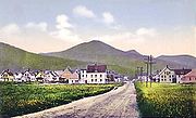
Lincoln is a town
in Grafton County, New Hampshire
, United States. It is the second-largest town by area in New Hampshire
. The population was 1,662 at the 2010 census. The town is home to the New Hampshire Highland Games and to a portion of Franconia Notch State Park
. Set in the White Mountains
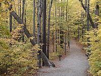
, large portions of the town are within the White Mountain National Forest
. The Appalachian Trail
crosses in the northeast. Lincoln is the location of the Loon Mountain
ski resort and associated recreation-centered development.
The primary settlement in town, where 993 people resided at the 2010 census, is defined as the Lincoln census-designated place
(CDP) and is located along New Hampshire Route 112
east of Interstate 93
. The town also includes the village of North Lincoln and the former village site of Stillwater.
 In 1764, Colonial Governor Benning Wentworth
granted 32456 acres (131.3 km²) to a group of approximately 70 land investors from Connecticut
. Lincoln was named after Henry Fiennes Pelham-Clinton, 2nd Duke of Newcastle, 9th Earl of Lincoln
– a cousin of the Wentworth governors. He held the position of comptroller
of customs
for the port of London
under George II and George III, which was important to trade between America
and England
.
The town was settled about 1782. The 1790 census indicates that it had 22 inhabitants. Rocky soil yielded poor farming, but the area's abundant timber
, combined with water power
to run sawmill
s on the Pemigewasset River
and its East Branch
, helped Lincoln develop into a center for logging. By 1853, the Merrimack River Lumber Company was operating. The railroad transported freight, and increasingly brought tourists to the beautiful mountain region. In 1892, James E. Henry bought approximately 100000 acres (404.7 km²) of virgin timber and established a logging enterprise at what is today the center of Lincoln. In 1902, he built a pulp and paper mill
. He erected The Lincoln House hotel in 1903, although a 1907 fire would nearly raze the community. Until he died in 1912, Henry controlled his company town
, installing relatives in positions of civic authority.
In 1917, Henry's heirs sold the business to the Parker Young Company, which in turn sold it to the Marcalus Manufacturing Company in 1946. Franconia Paper took over in 1950, producing 150 tons of paper a day until bankruptcy
in 1971, at which time new river classification standards discouraged further papermaking
in Lincoln.
Tourism
is today the principal business. Nearby Loon Mountain
has long drawn skiers
, and in recent years has attempted to convert itself into a four-season attraction. The Flume is one of the most visited attractions in the state. Discovered in 1808, it is a natural canyon
extending 800 feet (243.8 m) at the base of Mount Liberty
. Walls of Conway granite
rise to a height of 70 to 90 feet (21 to 27 m) and are only 12 to 20 feet (2.5 to 6.0 m) apart.
, the town has a total area of 130.9 square miles (339 km²). 130.3 square miles (337.5 km²) of it is land and 0.6 square miles (1.6 km²) of it is water, comprising 0.43% of the town. It is the second-largest town in area in New Hampshire (after Pittsburg
).
Lincoln is drained by the Pemigewasset River
and its East Branch
. Lincoln lies almost fully within the Merrimack River
watershed
, with the western edge of town in the Connecticut River
watershed. Kancamagus Pass, elevation 2860 feet (871.7 m), is on the Kancamagus Highway at the eastern boundary. The highest point in Lincoln is either the summit of Mount Carrigain
, at 4700 ft (1,432.6 m) above sea level
, plus or minus 10 ft (3 m), or the summit of Mount Bond
at 4698 ft (1,432 m).
 As of the census of 2000, there were 1,271 people, 583 households, and 324 families residing in the town. The population density
was 9.7 people per square mile (3.8/km²). There were 2,339 housing units at an average density of 17.9 per square mile (6.9/km²). The racial makeup of the town was 97.40% White, 0.39% Native American, 0.87% Asian, 0.16% from other races
, and 1.18% from two or more races. 0.71% of the population were Hispanic or Latino of any race.
There were 583 households out of which 22.8% had children under the age of 18 living with them, 43.4% were married couples living together, 8.9% had a female householder with no husband present, and 44.4% were non-families. 35.7% of all households were made up of individuals and 12.7% had someone living alone who was 65 years of age or older. The average household size was 2.18 and the average family size was 2.83.
In the town the population was spread out with 19.8% under the age of 18, 7.1% from 18 to 24, 27.9% from 25 to 44, 27.9% from 45 to 64, and 17.4% who were 65 years of age or older. The median age was 43 years. For every 100 females there were 99.2 males. For every 100 females age 18 and over, there were 96.7 males.
The median income for a household in the town was $28,523, and the median income for a family was $44,063. Males had a median income of $25,263 versus $22,784 for females. The per capita income
for the town was $17,999. About 3.4% of families and 8.0% of the population were below the poverty line
, including 5.3% of those under age 18 and 5.5% of those age 65 or over.
New England town
The New England town is the basic unit of local government in each of the six New England states. Without a direct counterpart in most other U.S. states, New England towns are conceptually similar to civil townships in other states, but are incorporated, possessing powers like cities in other...
in Grafton County, New Hampshire
Grafton County, New Hampshire
Grafton County is a county located in the U.S. state of New Hampshire. As of the 2010 census, the population was 89,118. Its county seat is North Haverhill, which is a village within the town of Haverhill. Until 1972, the county courthouse and other offices were located in downtown Woodsville, a...
, United States. It is the second-largest town by area in New Hampshire
New Hampshire
New Hampshire is a state in the New England region of the northeastern United States of America. The state was named after the southern English county of Hampshire. It is bordered by Massachusetts to the south, Vermont to the west, Maine and the Atlantic Ocean to the east, and the Canadian...
. The population was 1,662 at the 2010 census. The town is home to the New Hampshire Highland Games and to a portion of Franconia Notch State Park
Franconia Notch State Park
Franconia Notch State Park is located in the White Mountains in northern New Hampshire and straddles of Interstate 93 as it passes through Franconia Notch, a mountain pass between the Kinsman Range and Franconia Range...
. Set in the White Mountains
White Mountains (New Hampshire)
The White Mountains are a mountain range covering about a quarter of the state of New Hampshire and a small portion of western Maine in the United States. Part of the Appalachian Mountains, they are considered the most rugged mountains in New England...
, large portions of the town are within the White Mountain National Forest
White Mountain National Forest
The White Mountain National Forest is a federally-managed forest contained within the White Mountains in the northeastern United States. It was established in 1918 as a result of the Weeks Act of 1911; federal acquisition of land had already begun in 1914. It has a total area of...
. The Appalachian Trail
Appalachian Trail
The Appalachian National Scenic Trail, generally known as the Appalachian Trail or simply the AT, is a marked hiking trail in the eastern United States extending between Springer Mountain in Georgia and Mount Katahdin in Maine. It is approximately long...
crosses in the northeast. Lincoln is the location of the Loon Mountain
Loon Mountain
Loon Mountain is a mountain in Lincoln, New Hampshire, in Grafton County. It is in the White Mountain National Forest.The mountain is known for Loon Mountain Ski Resort, which, like most New England mountain resorts, has expanded into an all-season recreation area.-External links:* - Official site*...
ski resort and associated recreation-centered development.
The primary settlement in town, where 993 people resided at the 2010 census, is defined as the Lincoln census-designated place
Census-designated place
A census-designated place is a concentration of population identified by the United States Census Bureau for statistical purposes. CDPs are delineated for each decennial census as the statistical counterparts of incorporated places such as cities, towns and villages...
(CDP) and is located along New Hampshire Route 112
New Hampshire Route 112
New Hampshire Route 112 is a long east–west state highway in northern New Hampshire. The highway winds across the state, connecting Bath to Conway via the scenic and mountainous area of the White Mountain National Forest. Part of this highway, which runs through the White Mountains, is known as...
east of Interstate 93
Interstate 93
Interstate 93 is an Interstate Highway in the New England section of the United States. Its southern terminus is in Canton, Massachusetts, in the Boston metropolitan area, at Interstate 95; its northern terminus is near St. Johnsbury, Vermont, at Interstate 91...
. The town also includes the village of North Lincoln and the former village site of Stillwater.
History
Benning Wentworth
Benning Wentworth was the colonial governor of New Hampshire from 1741 to 1766.-Biography:The eldest child of the John Wentworth who had been Lieutenant Governor, he was born and died in Portsmouth, New Hampshire. Wentworth graduated from Harvard College in 1715...
granted 32456 acres (131.3 km²) to a group of approximately 70 land investors from Connecticut
Connecticut
Connecticut is a state in the New England region of the northeastern United States. It is bordered by Rhode Island to the east, Massachusetts to the north, and the state of New York to the west and the south .Connecticut is named for the Connecticut River, the major U.S. river that approximately...
. Lincoln was named after Henry Fiennes Pelham-Clinton, 2nd Duke of Newcastle, 9th Earl of Lincoln
Earl of Lincoln
Earl of Lincoln is a title that has been created eight times in the Peerage of England.-Earls of Lincoln, First Creation :*William d'Aubigny, 1st Earl of Lincoln and 1st Earl of Arundel Earl of Lincoln is a title that has been created eight times in the Peerage of England.-Earls of Lincoln, First...
– a cousin of the Wentworth governors. He held the position of comptroller
Comptroller
A comptroller is a management level position responsible for supervising the quality of accounting and financial reporting of an organization.In British government, the Comptroller General or Comptroller and Auditor General is in most countries the external auditor of the budget execution of the...
of customs
Customs
Customs is an authority or agency in a country responsible for collecting and safeguarding customs duties and for controlling the flow of goods including animals, transports, personal effects and hazardous items in and out of a country...
for the port of London
London
London is the capital city of :England and the :United Kingdom, the largest metropolitan area in the United Kingdom, and the largest urban zone in the European Union by most measures. Located on the River Thames, London has been a major settlement for two millennia, its history going back to its...
under George II and George III, which was important to trade between America
British North America
British North America is a historical term. It consisted of the colonies and territories of the British Empire in continental North America after the end of the American Revolutionary War and the recognition of American independence in 1783.At the start of the Revolutionary War in 1775 the British...
and England
England
England is a country that is part of the United Kingdom. It shares land borders with Scotland to the north and Wales to the west; the Irish Sea is to the north west, the Celtic Sea to the south west, with the North Sea to the east and the English Channel to the south separating it from continental...
.
The town was settled about 1782. The 1790 census indicates that it had 22 inhabitants. Rocky soil yielded poor farming, but the area's abundant timber
Lumber
Lumber or timber is wood in any of its stages from felling through readiness for use as structural material for construction, or wood pulp for paper production....
, combined with water power
Hydropower
Hydropower, hydraulic power, hydrokinetic power or water power is power that is derived from the force or energy of falling water, which may be harnessed for useful purposes. Since ancient times, hydropower has been used for irrigation and the operation of various mechanical devices, such as...
to run sawmill
Sawmill
A sawmill is a facility where logs are cut into boards.-Sawmill process:A sawmill's basic operation is much like those of hundreds of years ago; a log enters on one end and dimensional lumber exits on the other end....
s on the Pemigewasset River
Pemigewasset River
The Pemigewasset River , known locally as "The Pemi", is a river in the state of New Hampshire, the United States. It is in length and drains approximately...
and its East Branch
East Branch Pemigewasset River
The East Branch of the Pemigewasset River is a river located in the White Mountains of New Hampshire in the United States. It is a tributary of the Pemigewasset River, part of the Merrimack River watershed....
, helped Lincoln develop into a center for logging. By 1853, the Merrimack River Lumber Company was operating. The railroad transported freight, and increasingly brought tourists to the beautiful mountain region. In 1892, James E. Henry bought approximately 100000 acres (404.7 km²) of virgin timber and established a logging enterprise at what is today the center of Lincoln. In 1902, he built a pulp and paper mill
Paper mill
A paper mill is a factory devoted to making paper from vegetable fibres such as wood pulp, old rags and other ingredients using a Fourdrinier machine or other type of paper machine.- History :...
. He erected The Lincoln House hotel in 1903, although a 1907 fire would nearly raze the community. Until he died in 1912, Henry controlled his company town
Company town
A company town is a town or city in which much or all real estate, buildings , utilities, hospitals, small businesses such as grocery stores and gas stations, and other necessities or luxuries of life within its borders are owned by a single company...
, installing relatives in positions of civic authority.
In 1917, Henry's heirs sold the business to the Parker Young Company, which in turn sold it to the Marcalus Manufacturing Company in 1946. Franconia Paper took over in 1950, producing 150 tons of paper a day until bankruptcy
Bankruptcy
Bankruptcy is a legal status of an insolvent person or an organisation, that is, one that cannot repay the debts owed to creditors. In most jurisdictions bankruptcy is imposed by a court order, often initiated by the debtor....
in 1971, at which time new river classification standards discouraged further papermaking
Papermaking
Papermaking is the process of making paper, a substance which is used universally today for writing and packaging.In papermaking a dilute suspension of fibres in water is drained through a screen, so that a mat of randomly interwoven fibres is laid down. Water is removed from this mat of fibres by...
in Lincoln.
Tourism
Tourism
Tourism is travel for recreational, leisure or business purposes. The World Tourism Organization defines tourists as people "traveling to and staying in places outside their usual environment for not more than one consecutive year for leisure, business and other purposes".Tourism has become a...
is today the principal business. Nearby Loon Mountain
Loon Mountain
Loon Mountain is a mountain in Lincoln, New Hampshire, in Grafton County. It is in the White Mountain National Forest.The mountain is known for Loon Mountain Ski Resort, which, like most New England mountain resorts, has expanded into an all-season recreation area.-External links:* - Official site*...
has long drawn skiers
Skiing
Skiing is a recreational activity using skis as equipment for traveling over snow. Skis are used in conjunction with boots that connect to the ski with use of a binding....
, and in recent years has attempted to convert itself into a four-season attraction. The Flume is one of the most visited attractions in the state. Discovered in 1808, it is a natural canyon
Canyon
A canyon or gorge is a deep ravine between cliffs often carved from the landscape by a river. Rivers have a natural tendency to reach a baseline elevation, which is the same elevation as the body of water it will eventually drain into. This forms a canyon. Most canyons were formed by a process of...
extending 800 feet (243.8 m) at the base of Mount Liberty
Mount Liberty (New Hampshire)
Mount Liberty is a high mountain in the White Mountains of New Hampshire. It is part of Franconia Ridge, a minor mountain range overlooking Franconia Notch, whose highest summit is Mount Lafayette....
. Walls of Conway granite
Granite
Granite is a common and widely occurring type of intrusive, felsic, igneous rock. Granite usually has a medium- to coarse-grained texture. Occasionally some individual crystals are larger than the groundmass, in which case the texture is known as porphyritic. A granitic rock with a porphyritic...
rise to a height of 70 to 90 feet (21 to 27 m) and are only 12 to 20 feet (2.5 to 6.0 m) apart.
Geography
According to the United States Census BureauUnited States Census Bureau
The United States Census Bureau is the government agency that is responsible for the United States Census. It also gathers other national demographic and economic data...
, the town has a total area of 130.9 square miles (339 km²). 130.3 square miles (337.5 km²) of it is land and 0.6 square miles (1.6 km²) of it is water, comprising 0.43% of the town. It is the second-largest town in area in New Hampshire (after Pittsburg
Pittsburg, New Hampshire
Pittsburg is a town in Coos County, New Hampshire, United States. The population was 869 at the 2010 census. It is the northernmost town in New Hampshire and the largest town by area in the state - and in New England as well - more than twice the size of the next largest town, Lincoln. U.S...
).
Lincoln is drained by the Pemigewasset River
Pemigewasset River
The Pemigewasset River , known locally as "The Pemi", is a river in the state of New Hampshire, the United States. It is in length and drains approximately...
and its East Branch
East Branch Pemigewasset River
The East Branch of the Pemigewasset River is a river located in the White Mountains of New Hampshire in the United States. It is a tributary of the Pemigewasset River, part of the Merrimack River watershed....
. Lincoln lies almost fully within the Merrimack River
Merrimack River
The Merrimack River is a river in the northeastern United States. It rises at the confluence of the Pemigewasset and Winnipesaukee rivers in Franklin, New Hampshire, flows southward into Massachusetts, and then flows northeast until it empties into the Atlantic Ocean at Newburyport...
watershed
Drainage basin
A drainage basin is an extent or an area of land where surface water from rain and melting snow or ice converges to a single point, usually the exit of the basin, where the waters join another waterbody, such as a river, lake, reservoir, estuary, wetland, sea, or ocean...
, with the western edge of town in the Connecticut River
Connecticut River
The Connecticut River is the largest and longest river in New England, and also an American Heritage River. It flows roughly south, starting from the Fourth Connecticut Lake in New Hampshire. After flowing through the remaining Connecticut Lakes and Lake Francis, it defines the border between the...
watershed. Kancamagus Pass, elevation 2860 feet (871.7 m), is on the Kancamagus Highway at the eastern boundary. The highest point in Lincoln is either the summit of Mount Carrigain
Mount Carrigain
Mount Carrigain is a mountain located in Grafton County, New Hampshire. The mountain is named after Phillip Carrigain, NH Secretary of State , and is on the south side of the Pemigewasset Wilderness, the source of the East Branch of the Pemigewasset River in the heart of the White Mountains,...
, at 4700 ft (1,432.6 m) above sea level
Sea level
Mean sea level is a measure of the average height of the ocean's surface ; used as a standard in reckoning land elevation...
, plus or minus 10 ft (3 m), or the summit of Mount Bond
Mount Bond
Mount Bond is a mountain located in Grafton County, New Hampshire, United States. The mountain is named after Professor George P. Bond of Harvard University, and is the southernmost extension of the Twin Range of the White Mountains. Mount Bond is flanked to the north by Mount Guyot.Mount Bond...
at 4698 ft (1,432 m).
Demographics
Population density
Population density is a measurement of population per unit area or unit volume. It is frequently applied to living organisms, and particularly to humans...
was 9.7 people per square mile (3.8/km²). There were 2,339 housing units at an average density of 17.9 per square mile (6.9/km²). The racial makeup of the town was 97.40% White, 0.39% Native American, 0.87% Asian, 0.16% from other races
Race (United States Census)
Race and ethnicity in the United States Census, as defined by the Federal Office of Management and Budget and the United States Census Bureau, are self-identification data items in which residents choose the race or races with which they most closely identify, and indicate whether or not they are...
, and 1.18% from two or more races. 0.71% of the population were Hispanic or Latino of any race.
There were 583 households out of which 22.8% had children under the age of 18 living with them, 43.4% were married couples living together, 8.9% had a female householder with no husband present, and 44.4% were non-families. 35.7% of all households were made up of individuals and 12.7% had someone living alone who was 65 years of age or older. The average household size was 2.18 and the average family size was 2.83.
In the town the population was spread out with 19.8% under the age of 18, 7.1% from 18 to 24, 27.9% from 25 to 44, 27.9% from 45 to 64, and 17.4% who were 65 years of age or older. The median age was 43 years. For every 100 females there were 99.2 males. For every 100 females age 18 and over, there were 96.7 males.
The median income for a household in the town was $28,523, and the median income for a family was $44,063. Males had a median income of $25,263 versus $22,784 for females. The per capita income
Per capita income
Per capita income or income per person is a measure of mean income within an economic aggregate, such as a country or city. It is calculated by taking a measure of all sources of income in the aggregate and dividing it by the total population...
for the town was $17,999. About 3.4% of families and 8.0% of the population were below the poverty line
Poverty threshold
The poverty threshold, or poverty line, is the minimum level of income deemed necessary to achieve an adequate standard of living in a given country...
, including 5.3% of those under age 18 and 5.5% of those age 65 or over.
Sites of interest
- Clark's Trading Post
- The Flume Gorge & Visitor Center
- Hobo RailroadHobo RailroadThe Hobo Railroad consists of two heritage railroads in central New Hampshire, in the United States.One, in Lincoln, offers passenger excursion trains through the White Mountains...
- Papermill Theatre, North Country Center for the Arts
- Upper Pemigewasset Historical Society & Museum
- Whale's Tale Water ParkWhale's Tale Water ParkWhale's Tale Water Park is a waterpark located in Lincoln, New Hampshire. The park has a number of rides and recently opened a side attraction called Castaway Cove....