Pemigewasset River
Encyclopedia
New Hampshire
New Hampshire is a state in the New England region of the northeastern United States of America. The state was named after the southern English county of Hampshire. It is bordered by Massachusetts to the south, Vermont to the west, Maine and the Atlantic Ocean to the east, and the Canadian...
, the United States
United States
The United States of America is a federal constitutional republic comprising fifty states and a federal district...
. It is 65 miles (104.6 km) in length and (with its tributaries) drains approximately 1021 square miles (2,644 km²). The name "Pemigewasset" comes from the Abenaki
Abenaki language
The Abenaki language is a dialect continuum within the Eastern Algonquian languages, originally spoken in what is now Vermont, New Hampshire, northern Massachusetts and Maine...
word bemijijoasek [bəmidzidzoasək], meaning "where side (entering) current is".
Geography
The Pemigewasset originates at Profile LakeProfile Lake
Profile Lake is a water body located in Franconia Notch in the White Mountains of New Hampshire, at the foot of Cannon Mountain. The lake was given its name due to its location directly beneath the Old Man of the Mountain, a famous rock formation which collapsed in 2003...
in Franconia Notch State Park
Franconia Notch State Park
Franconia Notch State Park is located in the White Mountains in northern New Hampshire and straddles of Interstate 93 as it passes through Franconia Notch, a mountain pass between the Kinsman Range and Franconia Range...
, in the town of Franconia
Franconia, New Hampshire
Franconia is a town in Grafton County, New Hampshire, United States. The population was 1,104 at the 2010 census. Set in the White Mountains, Franconia is home to the northern half of Franconia Notch State Park. Parts of the White Mountain National Forest are in the eastern and southern portions...
. It flows south through the White Mountains
White Mountains (New Hampshire)
The White Mountains are a mountain range covering about a quarter of the state of New Hampshire and a small portion of western Maine in the United States. Part of the Appalachian Mountains, they are considered the most rugged mountains in New England...
and merges with the Winnipesaukee River
Winnipesaukee River
The Winnipesaukee River is a river that connects Lake Winnipesaukee with the Pemigewasset and Merrimack rivers in Franklin, New Hampshire. The river is located in the Lakes Region of central New Hampshire. The total drainage area of the river is approximately .There are two distinct sections of...
to form the Merrimack River
Merrimack River
The Merrimack River is a river in the northeastern United States. It rises at the confluence of the Pemigewasset and Winnipesaukee rivers in Franklin, New Hampshire, flows southward into Massachusetts, and then flows northeast until it empties into the Atlantic Ocean at Newburyport...
at Franklin
Franklin, New Hampshire
The median income for a household in the city was $34,613, and the median income for a family was $41,698. Males had a median income of $32,318 versus $25,062 for females. The per capita income for the city was $17,155...
. The Merrimack then flows through southern New Hampshire, northeastern Massachusetts
Massachusetts
The Commonwealth of Massachusetts is a state in the New England region of the northeastern United States of America. It is bordered by Rhode Island and Connecticut to the south, New York to the west, and Vermont and New Hampshire to the north; at its east lies the Atlantic Ocean. As of the 2010...
and into the Atlantic Ocean
Atlantic Ocean
The Atlantic Ocean is the second-largest of the world's oceanic divisions. With a total area of about , it covers approximately 20% of the Earth's surface and about 26% of its water surface area...
.

Interstate 93
Interstate 93 is an Interstate Highway in the New England section of the United States. Its southern terminus is in Canton, Massachusetts, in the Boston metropolitan area, at Interstate 95; its northern terminus is near St. Johnsbury, Vermont, at Interstate 91...
highway runs parallel with the river between Franconia Notch
Franconia Notch
Franconia Notch is a major mountain pass through the White Mountains of New Hampshire. Dominated by Cannon Mountain, it lies principally within Franconia Notch State Park and is traversed by the Franconia Notch Parkway Franconia Notch (el. 1950 ft. / 590 m.) is a major mountain pass through...
and New Hampton
New Hampton, New Hampshire
New Hampton is a town in Belknap County, New Hampshire, United States. The population was 2,165 at the 2010 census. A winter sports resort area, New Hampton is home to George Duncan State Forest and to the New Hampton School, a private preparatory school established in 1821.The primary village in...
. The river passes through the communities of Lincoln
Lincoln, New Hampshire
Lincoln is a town in Grafton County, New Hampshire, United States. It is the second-largest town by area in New Hampshire. The population was 1,662 at the 2010 census. The town is home to the New Hampshire Highland Games and to a portion of Franconia Notch State Park. Set in the White Mountains,...
, North Woodstock
North Woodstock, New Hampshire
North Woodstock is a census-designated place in the town of Woodstock in Grafton County, New Hampshire. It had a population of 528 at the 2010 census....
, Woodstock
Woodstock, New Hampshire
Woodstock is a town in Grafton County, New Hampshire, United States. The population was 1,374 at the 2010 census. Woodstock includes the village of North Woodstock, the commercial center. Its extensive land area is largely forested, and includes the Hubbard Brook Experimental Forest. Parts of the...
, Thornton
Thornton, New Hampshire
Thornton is a town in Grafton County, New Hampshire, United States. The population was 2,490 at the 2010 census.- History :Thornton was incorporated in 1763, and named for Doctor Matthew Thornton, a signer of the Declaration of Independence.- Geography :...
, Campton
Campton, New Hampshire
Campton is a town in Grafton County, New Hampshire, United States. The population was 3,333 at the 2010 census. Campton, which includes the villages of Blair, Campton Hollow, Lower Campton and West Campton, is home to Blair State Forest and Livermore Falls State Forest...
, Plymouth
Plymouth, New Hampshire
Plymouth is a town in Grafton County, New Hampshire, United States, in the White Mountains Region. Plymouth is located at the convergence of the Pemigewasset and Baker rivers. The population was 6,990 at the 2010 census...
, Holderness
Holderness, New Hampshire
Holderness is a town in Grafton County, New Hampshire, United States. The population was 2,108 at the 2010 census. An agricultural and resort area, Holderness is home to the Squam Lakes Natural Science Center and is located on Squam Lake...
, Ashland
Ashland, New Hampshire
Ashland is a town in Grafton County, New Hampshire, United States. The population was 2,076 at the 2010 census. Located near the geographical center of the state, Ashland is home to Scribner-Fellows State Forest....
, Bridgewater
Bridgewater, New Hampshire
Bridgewater is a town in Grafton County, New Hampshire, United States. The population was 1,083 at the 2010 census.- History :The land comprising Bridgewater was originally part of a town known as New Chester, which was separated into Bridgewater, Bristol, Hill, Danbury, and Wilmot...
, Bristol
Bristol, New Hampshire
Bristol is a town in Grafton County, New Hampshire, United States. The population was 3,054 at the 2010 census. It is home to Wellington State Park, Sugar Hill State Forest, and Profile Falls on the Smith River...
, New Hampton, Hill
Hill, New Hampshire
Hill is a town in Merrimack County, New Hampshire, United States. The population was 1,089 at the 2010 census.- History :Originally granted as New Chester in 1753, the town took the name Hill in 1837 in honor of Isaac Hill, governor of New Hampshire from 1836 to 1839...
, Sanbornton
Sanbornton, New Hampshire
Sanbornton is a town in Belknap County, New Hampshire, United States. The population was 2,966 at the 2010 census. It includes the villages of North Sanbornton and Gaza.-History:...
, and Franklin.
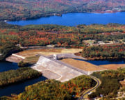
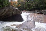
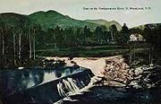
The river descends over waterfalls in Franconia Notch, including "The Basin", passes cascades in North Woodstock, and drops over Livermore Falls north of Plymouth. The remainder of the northern Pemi, from Lincoln to Ashland, passes over copious gravel bars and attracts numerous boaters and fishermen. Below Ashland, the river is impounded by the Ayers Island Dam
Ayers Island Reservoir
The Ayers Island Reservoir is an impoundment located on the Pemigewasset River in central New Hampshire, United States, in the towns of Bristol and New Hampton....
, a hydroelectric facility, for over five miles. A short stretch of heavy whitewater is found below the dam, before the river reaches the impoundment zone for the Franklin Falls flood control reservoir. The river crosses one additional hydroelectric dam below Franklin Falls before joining the Winnipesaukee River
Winnipesaukee River
The Winnipesaukee River is a river that connects Lake Winnipesaukee with the Pemigewasset and Merrimack rivers in Franklin, New Hampshire. The river is located in the Lakes Region of central New Hampshire. The total drainage area of the river is approximately .There are two distinct sections of...
in the center of Franklin.
The Pemigewasset watershed consists of over 1100 miles (1,770.3 km) of rivers and 17000 acres (69 km²) of lake, pond, and reservoir area. The watershed comprises about 20 percent of the Merrimack's total watershed area.
Tributaries
- East BranchEast Branch Pemigewasset RiverThe East Branch of the Pemigewasset River is a river located in the White Mountains of New Hampshire in the United States. It is a tributary of the Pemigewasset River, part of the Merrimack River watershed....
of the Pemigewasset River. The East Branch is larger and longer than the main branch of the river. - Lost RiverLost River (New Hampshire)The Lost River is a stream located in the White Mountains of New Hampshire in the United States. It is a tributary of the Pemigewasset River, part of the Merrimack River watershed....
- Mad River
- Beebe RiverBeebe RiverThe Beebe River is a river located in the White Mountains of New Hampshire in the United States. It is a tributary of the Pemigewasset River, part of the Merrimack River watershed....
- Baker RiverBaker River (New Hampshire)The Baker River, or Asquamchumauke, is a river in the White Mountains region of New Hampshire, the United States. It rises on the south side of Mount Moosilauke and runs south and east to empty into the Pemigewasset River in Plymouth. The river traverses the towns of Warren, Wentworth, and...
- Squam RiverSquam RiverThe Squam River is a river located in central New Hampshire in the United States. It is the outlet of Squam Lake, the second-largest lake in New Hampshire, and it is a tributary of the Pemigewasset River, which itself is a tributary of the Merrimack River....
(outlet of Squam LakeSquam LakeSquam Lake is a lake located in central New Hampshire, USA, south of the White Mountains, straddling the borders of Grafton, Carroll, and Belknap counties. The largest town center on the lake is Holderness...
) - Newfound RiverNewfound River (New Hampshire)The Newfound River is a river located in central New Hampshire in the United States. It is a tributary of the Pemigewasset River, part of the Merrimack River watershed.The Newfound River begins at the outlet of Newfound Lake in Bristol, New Hampshire...
(outlet of Newfound LakeNewfound LakeNewfound Lake is located in Grafton County, New Hampshire, USA, within the towns of Bridgewater, Bristol, Alexandria, and Hebron. The lake is located in a section of New Hampshire known as the Lakes Region. At 4,451 acres, it is the third-largest lake located entirely in New Hampshire. The lake's...
) - Smith RiverSmith River (Pemigewasset River)The Smith River is a river located in central New Hampshire in the United States. It is a tributary of the Pemigewasset River, part of the Merrimack River watershed....
See also