
Limey Way
Encyclopedia
The Limey Way is a 65-kilometre Challenge walk through Derbyshire
, England
. It starts at Castleton and progesses through 15 major and 5 minor limestone dales to reach the River Dove
and Dovedale, the walk's end.
The walk was first described in the 1960s and a Challenge Recorder was appointed: all persons who submitted a full verified account received a woven badge. The walk was later superseded by the Derbyshire Council's own walk, the Limestone Way
, which uses the route of the Limey Way down to Thorpe
and adds some extra mileage.
 The path follows the Derbyshire dales from one into another along the route and in its later stages includes some of the Tissington Trail
.
FINISH Dovedale Car Park
Derbyshire
Derbyshire is a county in the East Midlands of England. A substantial portion of the Peak District National Park lies within Derbyshire. The northern part of Derbyshire overlaps with the Pennines, a famous chain of hills and mountains. The county contains within its boundary of approx...
, England
England
England is a country that is part of the United Kingdom. It shares land borders with Scotland to the north and Wales to the west; the Irish Sea is to the north west, the Celtic Sea to the south west, with the North Sea to the east and the English Channel to the south separating it from continental...
. It starts at Castleton and progesses through 15 major and 5 minor limestone dales to reach the River Dove
River Dove, Derbyshire
The River Dove is the principal river of the southwestern Peak District, in the Midlands of England and is around in length. It rises on Axe Edge Moor near Buxton and flows generally south to its confluence with the River Trent at Newton Solney. From there, its waters reach the North Sea via the...
and Dovedale, the walk's end.
The walk was first described in the 1960s and a Challenge Recorder was appointed: all persons who submitted a full verified account received a woven badge. The walk was later superseded by the Derbyshire Council's own walk, the Limestone Way
Limestone Way
The Limestone Way is a long-distance bridleway in Derbyshire, England. It runs through the White Peak of the Peak District National Park, from Castleton south east to Rocester over the county boundary in Staffordshire. It originally ran to Matlock, but was diverted to its current, longer route to...
, which uses the route of the Limey Way down to Thorpe
Thorpe, Derbyshire
Thorpe is a village and civil parish in the English county of Derbyshire; it is on the Derbyshire/Staffordshire border, on the east bank of the River Dove, about four miles north of Ashbourne....
and adds some extra mileage.
Route
Tissington Trail
right|thumb|200px|The Trail at the site of the former Tissington station, now a picnic site.The Tissington Trail is a bridleway and walk/cycle path in Derbyshire, England...
.
- Castleton car park -
- Cave DaleCave DaleCave Dale is a dry limestone valley in the Derbyshire Peak District, England. It is located at grid reference . The northern end of the dale starts at the village of Castleton where the valley sides are almost perpendicular and over 50 metres in height...
- Hurdlow Barn
- Old Moor
- Peak ForestPeak ForestPeak Forest is a small village on the main road the from Chapel-en-le-Frith to Chesterfield in England.The village grew from the earlier settlement of Dam at the conjunction of Perrydale and Damdale. There is an inn, a village shop and a Primary School...
- - Dam Dale
- Hay Dale
- Wheston -
- Monksdale
- Millers DaleMillers DaleMillers Dale is a valley on the River Wye in Derbyshire.It is a popular beauty spot in the Peak District of England, much of the area being preserved as a Site of Special Scientific Interest. Nearby is Ravenstor and Cheedale, both popular with rock-climbers...
- Cressbrook Mill -
- Monsal DaleMonsal DaleMonsal Dale is a valley in the Peak District of Derbyshire in England.In geological history this area of Derbyshire was long ago under water, and is formed from a subsequent uplift of resultant sedimentary deposits, known as the Derbyshire Dome...
- Deepdale
- MonyashMonyashMonyash is a village in the Derbyshire Peak District about five miles west of Bakewell.Monyash lies at an elevation of 300m above sea level, and has a population of about 280 people. The village is located in a shallow hollow in the limestone plateau at the head of Lathkill Dale, which starts just...
- - Lathkill Dale
- Bradford Dale
- Smerrill Grange -
- Gratton Dale
- Long Dale
- Friden -
- Biggin Dale
- Wolfcote Dale
- Milldale -
- DovedaleDovedaleDovedale is a popular dale in the Peak District, England. It is owned by the National Trust, and annually attracts a million visitors. The valley is cut by the River Dove and runs for just over between Milldale in the north and a wooded ravine near Thorpe Cloud and Bunster Hill in the south...
- Thorpe CloudThorpe CloudThorpe Cloud is an isolated limestone hill lying between the villages of Thorpe and Ilam at the southern end of Dovedale. It is a popular hill amongst the many day-trippers who visit the area, and provides a fine viewpoint north up the dale and south across the Midland plain.Like much of the dale,...
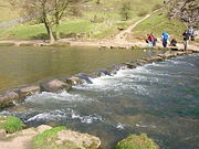
- River Dove Stepping Stones
FINISH Dovedale Car Park