

Lake Qaraoun
Encyclopedia
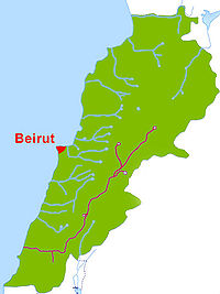
Lake Qaraoun is an artificial lake or reservoir located in the southern region of the Beqaa Valley
, Lebanon
. It was created in 1959 by building a 61 m high concrete-faced rockfill dam (the largest dam in Lebanon) in the middle reaches of the Litani River
(the longest river in Lebanon), near Qaraoun
village. The reservoir is used for hydropower generation (190 MW), irrigation (27,500 ha) and as a domestic water supply.
The annual surface water flow in the Litani River received at the Lake Qaraoun is 420 million cubic metres (million cubic metres). This flow is used for generating hydroelectric power of 600 GWh at three hydroelectric power stations at Markaba, Awali and Jun with the total installed capacity of 190 MW. During the dry season, 30 million cubic metres of water is diverted from Markaba power station to meet the needs of the Kassmieh irrigation project.
The lake is a habitat for 20,000 odd migratory birds which visit it annually.
 The upper Litani River, where the artificial lake or reservoir has been created with the dam at elevation of about 800 metres (2,624.7 ft), is in the inland region of Beqaa Valley
, whose elevation range generally lies between 650 metres (2,132.5 ft) and 1600 metres (5,249.3 ft), with mountain peaks raising as high as 3090 metres (10,137.8 ft).
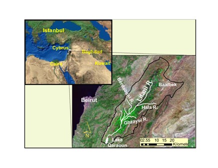
The Litani River drains the southern end of the Beqaa Valley plains (a continuation of the Great Rift Valley
), crossing the southern periphery of the Mount Lebanon
range and discharging into the sea north of Tyre
, after traversing a length of 170 kilometres (105.6 mi) entirely in Lebanon. The hydrographical system of Lebanon consisting of 40 major streams is typecast into five regions, which includes the Litani River Basin formed by the Litani River in its eastern and southern part, with the river debouching into the sea at the southwestern end. The basin has a total catchment area of 2120 km² (818.5 sq mi), which forms 20% area of the country, with about 1600 km² (617.8 sq mi) intercepted at the Lake Qaraoun by the El Wauroun Dam for providing various benefits. The artificial lake is created across the Litani River in its middle reaches. Litani River is the longest river in Lebanon at the southern end of the Beqaa valley.
The Litani River, which lies entirely within the territory of Lebanon rises near the historic city of Baalbek
(now the site hardly discernible due to high rate of water extraction in this reach for pumping and ancient city development) and flows through for 170 kilometres (105.6 mi) before it outlets into the Mediterranean Sea. It is one of the 40 major streams in Lebanon and is the longest from the source to the Mediterranean sea
.
The land on the periphery of the reservoir consists of agricultural lands on the eastern side where arable crops and olive
orchards are seen. Grazing of sheep and goats is also noted. On the steep sloping western periphery of the lake there are fruit orchards and pasture land for grazing.
, chalky marl, and alluvial deposits with semi karstic and karstic lime stones both upstream of the reservoir area and along the dam axis. Marl in the reservoir area has low permeability.
recharge and evapotranspiration
. Of the balance 500 million cubic metres year of surface water, 80 million cubic metres per year is used for various uses by pumping before the flow reaches the dam. Thus, the flow of 420 million cubic metres is available at the reservoir, in an average year (35-year average flows from 1920s). However, in drought years, the flow could reach a low of 320 million cubic metres (recorded in 1972–73). Based on precipitation data, the total annual flow could be as high as 700 million cubic metres. The average annual flow of 420 million cubic metres received at the reservoir is utilised through the dam created at the site and diverting it through a series of tunnels and ponds to generate 600 GWh of energy at three hydroelectric power stations (190 MW total installed capacity) located at Markaba
, Awali
and Jun. The planning done in the 1950s at the time of building the dam and the Qaraoun reservoir envisaged utilization of 800 metres (2,624.7 ft) head available between the dam and the Mediterranean Sea through the three power stations. The river outlet at the end of the cascade of power plants is now 30 kilometres (18.6 mi) to the north of its original outlet. It is also utilised for providing irrigation benefits by diverting 30 million cubic metres per year of water from a channel of the Markaba power station for the Kassmieh Irrigation Project.
As result of this development the hydrological regime of the Litani River has been divided into two zones; the basin above the lake is known as the Upper Litani Basin (ULB) and that below the lake as called Litani’s lower reaches.
 The Qaraoun reservoir or lake created by the El Wauroun Dam on the Litani River has a water spread area of 11.9 km² (4.6 sq mi). It is the largest artificial lake in Lebanon, located in the southern part of the fertile Beqaa Valley has a total capacity of about 220 million cubic metres and effective storage (live storage) of 160 million cubic metres. Apart from power generation as a primary benefit, which meets about 7–10% of power requirements of Lebanon, the stored waters also provide irrigation benefits with flows of 140 million cubic metres (110 million cubic metres is used in South Lebanon and 30 million cubic metres in Beqaa) while 20 million cubic metres is used for domestic water supply in the Southern Lebanon. Controlled reservoir operation also provides flood control benefits and prevention of water logging in an area of about 1500ha.
During 1999–2000, the water quality of the reservoir has been investigated from 16 sampling points on the river and its tributaries, by the Ministry of Environment and the Litani River Authority as an part of an exercise to evolve management plan for the Litani River and Lake Qaroun's catchment. It has been noted that seven sewer networks drain directly into the river. Untreated sewerage from the towns of Baalbek, Houch el Rafqa, Qaa er Rim, Zahle, Chtoura, Qabb Elias, Bar Elias, Joub Jannine and Qaraoun flow into the Litani River or its tributaries, apart from industrial effluents many factories related to manufacture of sugar, paper, lead, limestone crushers, agro-industries and also from poultry farms, tanneries and slaughterhouses. The pollution is noted by the high recorded values of BOD5
(79 mg/L) and nitrate
s (1.7 mg/L) in the Litani River.
The vegetation in the periphery of the lake consists of woodland, orchards, and low-growing scrub. During water level variations in the lake, as the stored water is utilised for various beneficial uses, no submerged or emergent vegetation have been noticed. When the water level is at its lowest in the lake, a steppe like land slope has been noticed with low vegetation of rocky shingle terrain where flocks of larks and lapwings are seen.
The bird life in the reservoir area is very notable as 20,000 migratory birds of species of raptors
, storks, pelicans and others species of birds have been sighted. Ferruginous duck
(Aythya nyroca), Pallid Harrier
(Circus macrourus), Greater Spotted Eagle
(Aquila clanga), Eastern Imperial Eagle
(Aquila heliaca) and Lapwing
(Vanellus gregarius) are some of the birds which are of conservation concern, according to the 2008 IUCN Red List
.
. The dam was under planning since 1964. The Qaraoun village transferred a land area of 760 hectares (1,878 acre) for building the dam. The dam, which created the artificial lake or reservoir, is the largest dam built in Lebanon for multipurpose uses of hydropower generation (190MW), irrigation (28500 hectares (70,425 acre)) and drinking water supply. It is a concrete-faced rockfill dam (CFRD) of 61 metres (200.1 ft) height built with crest level at EL 801 m with a dam length of 1090 metres (3,576.1 ft), over karstic lime stone formations. The reservoir has a storage capacity of 220 million cubic metres at maximum pond elevation of 858 m. The High Flood Level (HFL) in the reservoir is 862 m where the area of the lake is 12.6 km² (4.9 sq mi). The average water level for generation is 835 m with the lowest level or the minimum draw down level of 827 m.
The dam's upstream face is a concrete face of 47000 m² (56,211.5 sq yd) area, with thickness of concrete face varying from 50 centimetres (19.7 in) at the bottom to 30 centimetres (11.8 in) at the top. The spillway of the dam is designed for an inflow flood discharge of 450 m3/s. The reservoir has a storage capacity of 220 million cubic metres at maximum pond elevation of 858 m.
to Jezzine
. Jesuit archaeologist, Auguste Bergy
collected flint
s from the surface of this site, suggested to be similar to those of later neolithic
Byblos
.
Beqaa Valley
The Beqaa Valley is a fertile valley in east Lebanon. For the Romans, the Beqaa Valley was a major agricultural source, and today it remains Lebanon’s most important farming region...
, Lebanon
Lebanon
Lebanon , officially the Republic of LebanonRepublic of Lebanon is the most common term used by Lebanese government agencies. The term Lebanese Republic, a literal translation of the official Arabic and French names that is not used in today's world. Arabic is the most common language spoken among...
. It was created in 1959 by building a 61 m high concrete-faced rockfill dam (the largest dam in Lebanon) in the middle reaches of the Litani River
Litani River
The Litani River is an important water resource in southern Lebanon. The river rises in the fertile Beqaa Valley valley, west of Baalbek, and empties into the Mediterranean Sea north of Tyre. Exceeding 140 km in length, the Litani River is the longest river in Lebanon and provides an average...
(the longest river in Lebanon), near Qaraoun
Qaraoun
Qaraoun is a Lebanese village, 85 km from Beirut, known for its Lake Qaraoun in the Beqaa Valley formed by the El Wauroun Dam built in 1959. It is an ecologically fragile zone in the Rashaya District south of the Beqaa Governorate. The village lies about 2600 feet above sea level...
village. The reservoir is used for hydropower generation (190 MW), irrigation (27,500 ha) and as a domestic water supply.
The annual surface water flow in the Litani River received at the Lake Qaraoun is 420 million cubic metres (million cubic metres). This flow is used for generating hydroelectric power of 600 GWh at three hydroelectric power stations at Markaba, Awali and Jun with the total installed capacity of 190 MW. During the dry season, 30 million cubic metres of water is diverted from Markaba power station to meet the needs of the Kassmieh irrigation project.
The lake is a habitat for 20,000 odd migratory birds which visit it annually.
Geography
Beqaa Valley
The Beqaa Valley is a fertile valley in east Lebanon. For the Romans, the Beqaa Valley was a major agricultural source, and today it remains Lebanon’s most important farming region...
, whose elevation range generally lies between 650 metres (2,132.5 ft) and 1600 metres (5,249.3 ft), with mountain peaks raising as high as 3090 metres (10,137.8 ft).
The Litani River drains the southern end of the Beqaa Valley plains (a continuation of the Great Rift Valley
Great Rift Valley
The Great Rift Valley is a name given in the late 19th century by British explorer John Walter Gregory to the continuous geographic trench, approximately in length, that runs from northern Syria in Southwest Asia to central Mozambique in South East Africa...
), crossing the southern periphery of the Mount Lebanon
Mount Lebanon
Mount Lebanon , as a geographic designation, is a Lebanese mountain range, averaging above 2,200 meters in height and receiving a substantial amount of precipitation, including snow, which averages around four meters deep. It extends across the whole country along about , parallel to the...
range and discharging into the sea north of Tyre
Tyre
Tyre is a city in the South Governorate of Lebanon. There were approximately 117,000 inhabitants in 2003, however, the government of Lebanon has released only rough estimates of population numbers since 1932, so an accurate statistical accounting is not possible...
, after traversing a length of 170 kilometres (105.6 mi) entirely in Lebanon. The hydrographical system of Lebanon consisting of 40 major streams is typecast into five regions, which includes the Litani River Basin formed by the Litani River in its eastern and southern part, with the river debouching into the sea at the southwestern end. The basin has a total catchment area of 2120 km² (818.5 sq mi), which forms 20% area of the country, with about 1600 km² (617.8 sq mi) intercepted at the Lake Qaraoun by the El Wauroun Dam for providing various benefits. The artificial lake is created across the Litani River in its middle reaches. Litani River is the longest river in Lebanon at the southern end of the Beqaa valley.
The Litani River, which lies entirely within the territory of Lebanon rises near the historic city of Baalbek
Baalbek
Baalbek is a town in the Beqaa Valley of Lebanon, altitude , situated east of the Litani River. It is famous for its exquisitely detailed yet monumentally scaled temple ruins of the Roman period, when Baalbek, then known as Heliopolis, was one of the largest sanctuaries in the Empire...
(now the site hardly discernible due to high rate of water extraction in this reach for pumping and ancient city development) and flows through for 170 kilometres (105.6 mi) before it outlets into the Mediterranean Sea. It is one of the 40 major streams in Lebanon and is the longest from the source to the Mediterranean sea
Mediterranean Sea
The Mediterranean Sea is a sea connected to the Atlantic Ocean surrounded by the Mediterranean region and almost completely enclosed by land: on the north by Anatolia and Europe, on the south by North Africa, and on the east by the Levant...
.
The land on the periphery of the reservoir consists of agricultural lands on the eastern side where arable crops and olive
Olive
The olive , Olea europaea), is a species of a small tree in the family Oleaceae, native to the coastal areas of the eastern Mediterranean Basin as well as northern Iran at the south end of the Caspian Sea.Its fruit, also called the olive, is of major agricultural importance in the...
orchards are seen. Grazing of sheep and goats is also noted. On the steep sloping western periphery of the lake there are fruit orchards and pasture land for grazing.
Geology
The geological formation at the dam axis and the reservoir consists of limestoneLimestone
Limestone is a sedimentary rock composed largely of the minerals calcite and aragonite, which are different crystal forms of calcium carbonate . Many limestones are composed from skeletal fragments of marine organisms such as coral or foraminifera....
, chalky marl, and alluvial deposits with semi karstic and karstic lime stones both upstream of the reservoir area and along the dam axis. Marl in the reservoir area has low permeability.
Climate
The climate in the catchment of the reservoir is of continental type with 90% of rainfall occurring between November and April, with January experiencing the maximum precipitation. Snowfall is experienced at elevation above 1500 metres (4,921.3 ft). The rainfall incidence in the Beqaa Valley, which widely varies spatially and temporally, is an annual average of 1500 millimetres (59.1 in) in the mountainous region of the upper valley to a low of 700 millimetres (27.6 in) in the south in the coastal region. However, the average annual rainfall is 800 millimetres (31.5 in) in the catchment area of about 1600 km² (617.8 sq mi) at the reservoir carted at the dam.Water resources
According to water balance studies carried out for the Litani River, the total inflow of the river at the reservoir location has been assessed as 1,280 million cubic metres per year, of which 60% is accounted towards aquiferAquifer
An aquifer is a wet underground layer of water-bearing permeable rock or unconsolidated materials from which groundwater can be usefully extracted using a water well. The study of water flow in aquifers and the characterization of aquifers is called hydrogeology...
recharge and evapotranspiration
Evapotranspiration
Evapotranspiration is a term used to describe the sum of evaporation and plant transpiration from the Earth's land surface to atmosphere. Evaporation accounts for the movement of water to the air from sources such as the soil, canopy interception, and waterbodies...
. Of the balance 500 million cubic metres year of surface water, 80 million cubic metres per year is used for various uses by pumping before the flow reaches the dam. Thus, the flow of 420 million cubic metres is available at the reservoir, in an average year (35-year average flows from 1920s). However, in drought years, the flow could reach a low of 320 million cubic metres (recorded in 1972–73). Based on precipitation data, the total annual flow could be as high as 700 million cubic metres. The average annual flow of 420 million cubic metres received at the reservoir is utilised through the dam created at the site and diverting it through a series of tunnels and ponds to generate 600 GWh of energy at three hydroelectric power stations (190 MW total installed capacity) located at Markaba
Markaba
Markaba is a village located at Marjayoun municipality at Nabatieh Governorate, Lebanon. It is geographically located south of Raabatt Tallame, East of Banni Hayyan and North east of Tallussah and 850 M larges.- Climate:...
, Awali
Awali
Awali is a small municipality located approximately in the centre of the Kingdom of Bahrain, a small island in the Persian Gulf. Founded in the 1930s by the Bahrain Petroleum Company, it is populated mostly by workers of various nationalities from around the world whose skills were needed in the...
and Jun. The planning done in the 1950s at the time of building the dam and the Qaraoun reservoir envisaged utilization of 800 metres (2,624.7 ft) head available between the dam and the Mediterranean Sea through the three power stations. The river outlet at the end of the cascade of power plants is now 30 kilometres (18.6 mi) to the north of its original outlet. It is also utilised for providing irrigation benefits by diverting 30 million cubic metres per year of water from a channel of the Markaba power station for the Kassmieh Irrigation Project.
As result of this development the hydrological regime of the Litani River has been divided into two zones; the basin above the lake is known as the Upper Litani Basin (ULB) and that below the lake as called Litani’s lower reaches.
Reservoir
During 1999–2000, the water quality of the reservoir has been investigated from 16 sampling points on the river and its tributaries, by the Ministry of Environment and the Litani River Authority as an part of an exercise to evolve management plan for the Litani River and Lake Qaroun's catchment. It has been noted that seven sewer networks drain directly into the river. Untreated sewerage from the towns of Baalbek, Houch el Rafqa, Qaa er Rim, Zahle, Chtoura, Qabb Elias, Bar Elias, Joub Jannine and Qaraoun flow into the Litani River or its tributaries, apart from industrial effluents many factories related to manufacture of sugar, paper, lead, limestone crushers, agro-industries and also from poultry farms, tanneries and slaughterhouses. The pollution is noted by the high recorded values of BOD5
Biochemical oxygen demand
Biochemical oxygen demand or B.O.D. is the amount of dissolved oxygen needed by aerobic biological organisms in a body of water to break down organic material present in a given water sample at certain temperature over a specific time period. The term also refers to a chemical procedure for...
(79 mg/L) and nitrate
Nitrate
The nitrate ion is a polyatomic ion with the molecular formula NO and a molecular mass of 62.0049 g/mol. It is the conjugate base of nitric acid, consisting of one central nitrogen atom surrounded by three identically-bonded oxygen atoms in a trigonal planar arrangement. The nitrate ion carries a...
s (1.7 mg/L) in the Litani River.
The vegetation in the periphery of the lake consists of woodland, orchards, and low-growing scrub. During water level variations in the lake, as the stored water is utilised for various beneficial uses, no submerged or emergent vegetation have been noticed. When the water level is at its lowest in the lake, a steppe like land slope has been noticed with low vegetation of rocky shingle terrain where flocks of larks and lapwings are seen.
The bird life in the reservoir area is very notable as 20,000 migratory birds of species of raptors
Bird of prey
Birds of prey are birds that hunt for food primarily on the wing, using their keen senses, especially vision. They are defined as birds that primarily hunt vertebrates, including other birds. Their talons and beaks tend to be relatively large, powerful and adapted for tearing and/or piercing flesh....
, storks, pelicans and others species of birds have been sighted. Ferruginous duck
Ferruginous Duck
The Ferruginous Duck is a medium-sized diving duck from Eurasia. The species is known colloquially by birders as "Fudge Duck"....
(Aythya nyroca), Pallid Harrier
Pallid Harrier
The Pale or Pallid Harrier is a migratory bird of prey of the harrier family. It breeds in southern parts of eastern Europe and central Asia and winters mainly in India and southeast Asia...
(Circus macrourus), Greater Spotted Eagle
Greater Spotted Eagle
The Greater Spotted Eagle , occasionally just called the spotted eagle, is a large bird of prey. Like all typical eagles, it belongs to the family Accipitridae...
(Aquila clanga), Eastern Imperial Eagle
Eastern Imperial Eagle
The Eastern Imperial Eagle is a large species of bird of prey that breeds from southeastern Europe to central Asia. Most populations are migratory and winter in northeastern Africa, and southern and eastern Asia. The Spanish Imperial Eagle, found in Spain and Portugal, was formerly lumped with...
(Aquila heliaca) and Lapwing
Lapwing
Vanellinae are any of various crested plovers, family Charadriidae, noted for its slow, irregular wingbeat in flight and a shrill, wailing cry. Its length is 10-16 inches. They are a subfamily of medium-sized wading birds which also includes the plovers and dotterels. The Vanellinae are...
(Vanellus gregarius) are some of the birds which are of conservation concern, according to the 2008 IUCN Red List
IUCN Red List
The IUCN Red List of Threatened Species , founded in 1963, is the world's most comprehensive inventory of the global conservation status of biological species. The International Union for Conservation of Nature is the world's main authority on the conservation status of species...
.
El Wauroun Dam
The El Wauroun Dam built in the middle reaches of the Litani River, has created an artificial lake at (33°34′11.63"N 35°41′51.18"E) with water spread area of 1190 ha. It is situated about 70 km downstream of the historic city of from BaalbekBaalbek
Baalbek is a town in the Beqaa Valley of Lebanon, altitude , situated east of the Litani River. It is famous for its exquisitely detailed yet monumentally scaled temple ruins of the Roman period, when Baalbek, then known as Heliopolis, was one of the largest sanctuaries in the Empire...
. The dam was under planning since 1964. The Qaraoun village transferred a land area of 760 hectares (1,878 acre) for building the dam. The dam, which created the artificial lake or reservoir, is the largest dam built in Lebanon for multipurpose uses of hydropower generation (190MW), irrigation (28500 hectares (70,425 acre)) and drinking water supply. It is a concrete-faced rockfill dam (CFRD) of 61 metres (200.1 ft) height built with crest level at EL 801 m with a dam length of 1090 metres (3,576.1 ft), over karstic lime stone formations. The reservoir has a storage capacity of 220 million cubic metres at maximum pond elevation of 858 m. The High Flood Level (HFL) in the reservoir is 862 m where the area of the lake is 12.6 km² (4.9 sq mi). The average water level for generation is 835 m with the lowest level or the minimum draw down level of 827 m.
The dam's upstream face is a concrete face of 47000 m² (56,211.5 sq yd) area, with thickness of concrete face varying from 50 centimetres (19.7 in) at the bottom to 30 centimetres (11.8 in) at the top. The spillway of the dam is designed for an inflow flood discharge of 450 m3/s. The reservoir has a storage capacity of 220 million cubic metres at maximum pond elevation of 858 m.
Future developments
The lake water is proposed to be integrated with a pumped storage scheme planned under the "Qaraoun Lake-Marj et Taouil :Project". The plan is to utilise the water stored in this reservoir to be pumped to an upper reservoir (with a 50.6 metres (166 ft) high dam at maximum water level of 1679 m to store water pumped from the Qaraoun Lake or reservoir) to maximize power generation during the daily lean period (off peak hours) of power generation when load demand is low. In this mode of generation, the pumping will require 560 MW that would result in a generation of 388 MW of power.Archaeology
The archaeological site of Ain Jaouze overlooks Lake Qaraoun at the foot of Jebel Baruk on the west of the road from ChtauraChtaura
Chtaura is a town in Lebanon in the fertile Beqaa valley located between the Mount Lebanon and the Anti-Lebanon mountain range. It is located halfway on the Beirut Damascus highway. It is located 44 km from Beirut....
to Jezzine
Jezzine
Jezzine is a town in Lebanon, located from Sidon and south of Beirut. Surrounded by mountain peaks, pine forests, and at an average altitude of 950 m , it is the main summer resort and tourist destination of South Lebanon...
. Jesuit archaeologist, Auguste Bergy
Auguste Bergy
Reverend Father Auguste Bergy, born 1873 in France and died 31 August 1955 was a French Jesuit archaeologist notable for his work on prehistory in Lebanon.He is known particularly for excavations and studies at the Sands of Beirut and at Ras Beirut...
collected flint
Flint
Flint is a hard, sedimentary cryptocrystalline form of the mineral quartz, categorized as a variety of chert. It occurs chiefly as nodules and masses in sedimentary rocks, such as chalks and limestones. Inside the nodule, flint is usually dark grey, black, green, white, or brown in colour, and...
s from the surface of this site, suggested to be similar to those of later neolithic
Neolithic
The Neolithic Age, Era, or Period, or New Stone Age, was a period in the development of human technology, beginning about 9500 BC in some parts of the Middle East, and later in other parts of the world. It is traditionally considered as the last part of the Stone Age...
Byblos
Byblos
Byblos is the Greek name of the Phoenician city Gebal . It is a Mediterranean city in the Mount Lebanon Governorate of present-day Lebanon under the current Arabic name of Jubayl and was also referred to as Gibelet during the Crusades...
.