
La Sal Range
Encyclopedia
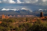
The La Sal Mountains are located in Grand
and San Juan
counties, near the eastern border of the state of Utah
, and rising above the town of Moab
. This range is part of the Manti-La Sal National Forest
and the southern Rocky Mountains
. The maximum elevation is at Mount Peale, reaching 12,721 feet (3,877 m) above sea level. The range contains three clusters of peaks separated by passes. The peaks span a distance of about 18 miles (25 km). The name of the range dates to Spanish times, when the Sierra La Sal (meaning the "Salt Mountains") were a prominent landmark on the Old Spanish Trail
between Santa Fe and Los Angeles. The range is also known as the La Sal Range.
 The range formed as a result of intrusion of igneous rock
s and subsequent erosion of the surrounding less-resistant sedimentary rocks. The most abundant igneous rocks are porphyritic
, with phenocrysts of hornblende
and plagioclase
: these rocks are called diorite
in some accounts but trachyte
in at least one other source. Syenite
, some containing the unusual mineral nosean
, makes up a few percent of the igneous rocks present. Some of the igneous intrusions have the shapes of laccolith
s. Ages of these igneous rocks fall in the interval 25 to 28 million years. The magmas were emplaced into sedimentary rocks with ages from Permian
to Cretaceous
.
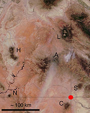
The La Sal Mountains rises high over the surrounding Colorado Plateau
. Two other ranges on the Plateau, the Abajo Mountains
and the Henry Mountains
, formed around igneous intrusions of about the same age. Yet other nearby ranges, such as the Carrizo Mountains
and Ute Mountain
, formed about otherwise similar intrusions emplaced about 70 million years ago. Formation of these igneous rocks in two distinct time intervals has attracted the interest of scientists seeking explanations for magma production below relatively stable parts of the Earth's crust.
 The significant peaks of the La Sal Mountains are:
Grand County, Utah
Grand County is a county located in the U.S. state of Utah. As of 2000 the population was 8,485, and by 2005 had been estimated at 8,743. It was named for the Colorado River, which at the time of statehood was known as the Grand River. Its county seat and largest city is Moab.-Geography:According...
and San Juan
San Juan County, Utah
As of the current census of 2010, there were 14,746 people and 4,505 households. The racial and ethnic composition of the population was 50.4% Native American, 45.8% white, 0.3% Asian, 0.2% African American and 2.3% reporting two or more races...
counties, near the eastern border of the state of Utah
Utah
Utah is a state in the Western United States. It was the 45th state to join the Union, on January 4, 1896. Approximately 80% of Utah's 2,763,885 people live along the Wasatch Front, centering on Salt Lake City. This leaves vast expanses of the state nearly uninhabited, making the population the...
, and rising above the town of Moab
Moab, Utah
Moab is a city in Grand County, in eastern Utah, in the western United States. The population was 4,779 at the 2000 census. It is the county seat and largest city in Grand County. Moab hosts a large number of tourists every year, mostly visitors to the nearby Arches and Canyonlands National Parks...
. This range is part of the Manti-La Sal National Forest
Manti-La Sal National Forest
The Manti-La Sal National Forest covers 1,270,646 acres and is located in the central and southeastern parts of the U.S. state of Utah and the extreme western part of Colorado...
and the southern Rocky Mountains
Rocky Mountains
The Rocky Mountains are a major mountain range in western North America. The Rocky Mountains stretch more than from the northernmost part of British Columbia, in western Canada, to New Mexico, in the southwestern United States...
. The maximum elevation is at Mount Peale, reaching 12,721 feet (3,877 m) above sea level. The range contains three clusters of peaks separated by passes. The peaks span a distance of about 18 miles (25 km). The name of the range dates to Spanish times, when the Sierra La Sal (meaning the "Salt Mountains") were a prominent landmark on the Old Spanish Trail
Old Spanish Trail (trade route)
The Old Spanish Trail is a historical trade route which connected the northern New Mexico settlements near or in Santa Fe, New Mexico with that of Los Angeles, California and southern California. Approximately long, it ran through areas of high mountains, arid deserts, and deep canyons. It is...
between Santa Fe and Los Angeles. The range is also known as the La Sal Range.
Igneous rock
Igneous rock is one of the three main rock types, the others being sedimentary and metamorphic rock. Igneous rock is formed through the cooling and solidification of magma or lava...
s and subsequent erosion of the surrounding less-resistant sedimentary rocks. The most abundant igneous rocks are porphyritic
Porphyritic
Porphyritic is an adjective used in geology, specifically for igneous rocks, for a rock that has a distinct difference in the size of the crystals, with at least one group of crystals obviously larger than another group...
, with phenocrysts of hornblende
Hornblende
Hornblende is a complex inosilicate series of minerals .It is not a recognized mineral in its own right, but the name is used as a general or field term, to refer to a dark amphibole....
and plagioclase
Plagioclase
Plagioclase is an important series of tectosilicate minerals within the feldspar family. Rather than referring to a particular mineral with a specific chemical composition, plagioclase is a solid solution series, more properly known as the plagioclase feldspar series...
: these rocks are called diorite
Diorite
Diorite is a grey to dark grey intermediate intrusive igneous rock composed principally of plagioclase feldspar , biotite, hornblende, and/or pyroxene. It may contain small amounts of quartz, microcline and olivine. Zircon, apatite, sphene, magnetite, ilmenite and sulfides occur as accessory...
in some accounts but trachyte
Trachyte
Trachyte is an igneous volcanic rock with an aphanitic to porphyritic texture. The mineral assemblage consists of essential alkali feldspar; relatively minor plagioclase and quartz or a feldspathoid such as nepheline may also be present....
in at least one other source. Syenite
Syenite
Syenite is a coarse-grained intrusive igneous rock of the same general composition as granite but with the quartz either absent or present in relatively small amounts Syenite is a coarse-grained intrusive igneous rock of the same general composition as granite but with the quartz either absent or...
, some containing the unusual mineral nosean
Nosean
Nosean, also known as Noselite, is a mineral of the feldspathoid group with formula: Na8Al6Si6O24. It forms isometric crystals of variable color: white, grey, blue, green, to brown. It has a Mohs hardness of 5.5 to 6 and a specific gravity of 2.3 to 2.4. It is fluorescent. It is found in low silica...
, makes up a few percent of the igneous rocks present. Some of the igneous intrusions have the shapes of laccolith
Laccolith
A laccolith is a sheet intrusion that has been injected between two layers of sedimentary rock. The pressure of the magma is high enough that the overlying strata are forced upward, giving the laccolith a dome or mushroom-like form with a generally planar base.Laccoliths tend to form at relatively...
s. Ages of these igneous rocks fall in the interval 25 to 28 million years. The magmas were emplaced into sedimentary rocks with ages from Permian
Permian
The PermianThe term "Permian" was introduced into geology in 1841 by Sir Sir R. I. Murchison, president of the Geological Society of London, who identified typical strata in extensive Russian explorations undertaken with Edouard de Verneuil; Murchison asserted in 1841 that he named his "Permian...
to Cretaceous
Cretaceous
The Cretaceous , derived from the Latin "creta" , usually abbreviated K for its German translation Kreide , is a geologic period and system from circa to million years ago. In the geologic timescale, the Cretaceous follows the Jurassic period and is followed by the Paleogene period of the...
.
The La Sal Mountains rises high over the surrounding Colorado Plateau
Colorado Plateau
The Colorado Plateau, also called the Colorado Plateau Province, is a physiographic region of the Intermontane Plateaus, roughly centered on the Four Corners region of the southwestern United States. The province covers an area of 337,000 km2 within western Colorado, northwestern New Mexico,...
. Two other ranges on the Plateau, the Abajo Mountains
Abajo Mountains
The Abajo Mountains, also called the Blue Mountains, is a small mountain range west of Monticello, Utah, south of Canyonlands National Park and north of Blanding, Utah. The mountain range is located within the Manti-La Sal National Forest...
and the Henry Mountains
Henry Mountains
The Henry Mountains are located in the southeastern portion of the U.S. state of Utah and run in a generally north-south direction, extending over a distance of about 30 miles . They were named by John Wesley Powell in honour of Joseph Henry, the first secretary of the Smithsonian Institution. The...
, formed around igneous intrusions of about the same age. Yet other nearby ranges, such as the Carrizo Mountains
Carrizo Mountains
The Carrizo Mountains are a small range 15 to 20 km in diameter located on the Colorado Plateau in northeastern Arizona. The range is about southwest of the Four Corners. The highest summit, Pastora Peak, is in elevation, whereas elevations on the surrounding plateau are near . The mountains...
and Ute Mountain
Ute Mountain
Ute Mountain , is a peak within the Ute Mountains, a small mountain range in the southwestern corner of Colorado. It is on the northern edge of the Ute Mountain Ute Reservation. The Reservation forms the southwestern corner of the state and of Montezuma County.Nomenclature for this peak and its...
, formed about otherwise similar intrusions emplaced about 70 million years ago. Formation of these igneous rocks in two distinct time intervals has attracted the interest of scientists seeking explanations for magma production below relatively stable parts of the Earth's crust.
Peaks of the La Sal Mountains
- Mount PealeMount PealeMount Peale is the highest point in the La Sal Mountains of San Juan County, in the southeastern part of the US state of Utah. It is also the highest point in Utah outside the Uinta Mountains. It is located about southeast of Moab...
- 12,721 feet (3877 m) - Mount Mellenthin - 12,645 feet (3854 m)
- Mount Tukuhnikivatz - 12,482 feet (3805 m)
- Mount Waas - 12,331 feet (3758 m)
- Manns Peak - 12,272 feet (3741 m)
- Mount Laurel - 12,271 feet (3740 m)
- Mount Tomasaki - 12,239 feet (3730 m)
- Pilot Mountain - 12,200 feet (3719 m)
- Green Mountain - 12,163 feet (3707 m)
- Little Tuk - 12,048 feet (3672 m)
- Castle Peak - 12,044 feet (3671 m)
- La Sal Peak - 12,001 feet (3658 m)