

Kurbat Ivanov
Encyclopedia
Cossack
Cossacks are a group of predominantly East Slavic people who originally were members of democratic, semi-military communities in what is today Ukraine and Southern Russia inhabiting sparsely populated areas and islands in the lower Dnieper and Don basins and who played an important role in the...
explorers of Siberia
Siberia
Siberia is an extensive region constituting almost all of Northern Asia. Comprising the central and eastern portion of the Russian Federation, it was part of the Soviet Union from its beginning, as its predecessor states, the Tsardom of Russia and the Russian Empire, conquered it during the 16th...
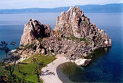
. He was the first Russian to discover Lake Baikal
Lake Baikal
Lake Baikal is the world's oldest at 30 million years old and deepest lake with an average depth of 744.4 metres.Located in the south of the Russian region of Siberia, between Irkutsk Oblast to the northwest and the Buryat Republic to the southeast, it is the most voluminous freshwater lake in the...
, and to create the first map of the Russian Far East
Russian Far East
Russian Far East is a term that refers to the Russian part of the Far East, i.e., extreme east parts of Russia, between Lake Baikal in Eastern Siberia and the Pacific Ocean...
. He also is credited with creation of the early map of Chukotka
Chukchi Peninsula
The Chukchi Peninsula, Chukotka Peninsula or Chukotski Peninsula , at about 66° N 172° W, is the northeastern extremity of Asia. Its eastern end is at Cape Dezhnev near the village of Uelen. It is bordered by the Chukchi Sea to the north, the Bering Sea to the south, and the Bering Strait to the...
and Bering Strait
Bering Strait
The Bering Strait , known to natives as Imakpik, is a sea strait between Cape Dezhnev, Chukotka Autonomous Okrug, Russia, the easternmost point of the Asian continent and Cape Prince of Wales, Alaska, USA, the westernmost point of the North American continent, with latitude of about 65°40'N,...
, which was the first to show (very schematically) the yet undiscovered Wrangel Island
Wrangel Island
Wrangel Island is an island in the Arctic Ocean, between the Chukchi Sea and East Siberian Sea. Wrangel Island lies astride the 180° meridian. The International Date Line is displaced eastwards at this latitude to avoid the island as well as the Chukchi Peninsula on the Russian mainland...
, both Diomede Islands
Diomede Islands
The Diomede Islands , also known in Russia as Gvozdev Islands , consist of two rocky, tuya-like islands:* The U.S. island of Little Diomede or, in its native language, Ignaluk , and* The Russian island of Big Diomede , also known as Imaqliq,...
and Alaska
Alaska
Alaska is the largest state in the United States by area. It is situated in the northwest extremity of the North American continent, with Canada to the east, the Arctic Ocean to the north, and the Pacific Ocean to the west and south, with Russia further west across the Bering Strait...
.
Initially Kurbat Ivanov was a Yeniseyan Cossack
Cossack
Cossacks are a group of predominantly East Slavic people who originally were members of democratic, semi-military communities in what is today Ukraine and Southern Russia inhabiting sparsely populated areas and islands in the lower Dnieper and Don basins and who played an important role in the...
. In 1642 he made the first map of the Russian Far East
Russian Far East
Russian Far East is a term that refers to the Russian part of the Far East, i.e., extreme east parts of Russia, between Lake Baikal in Eastern Siberia and the Pacific Ocean...
, based on the explorations of Ivan Moskvitin
Ivan Moskvitin
Ivan Yuryevich Moskvitin was a Russian explorer, presumably a native of Moscow, who led a Russian reconnaissance party to the Pacific Ocean, becoming the first Russian to reach the Sea of Okhotsk....
.
Ivanov came to the Verkholensky ostrog
Ostrog
Ostrog may refer to:* Ostrog, Slovenia, a settlement in Šentjernej municipality in Slovenia* Ostrog monastery, a Serbian Orthodox Christian monastery in Montenegro* Ostroh, a historic town in Ukraine* Ostrog, a Russian term for a small fortress...
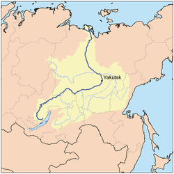
on Lena River
Lena River
The Lena is the easternmost of the three great Siberian rivers that flow into the Arctic Ocean . It is the 11th longest river in the world and has the 9th largest watershed...
, and taking 74 men with himself he sailed south up the river on 21 June of 1643, having decided to find if the rumors of large body of water south of Lena were true. He took with himself a Tungus prince Mozheul to assist in finding the way. Through the upper Lena and its tributary Ilikta they reached Primorsky Ridge
Baikal Mountains
thumb|right|300px|The mountains and lake in the summer, as seen from [[Bolshiye Koty]] on the southwest shoreThe Baikal Mountains or Baikal Range rise steeply over the northwestern shore of Lake Baikal in southern Siberia, Russia...
, crossed it by foot, and by river Sarma
Sarma River
Sarma is a river in Irkutsk Oblast, Russia. It runs from the Baikal Range into the Small Sea Strait of Lake Baikal.The valley and estuary of Sarma is the source of the strongest of Baikal winds, the Sarma wind. Its speed may exceed 40 meters per second....
descended to Baikal
Baikal
Baykal commonly refers to Lake Baikal in southern Siberia, Russia.Baykal or Baikal may also refer to:-Russia:*Baykal, Irkutsk Oblast, an urban-type settlement*Baykal, Aurgazinsky District, Republic of Bashkortostan, a village...
near Olkhon Island. Having built new boats, Ivanov sailed to Olkhon.
Ivanov sent 36 men under the leadership of Semyon Skorokhodov to sail along the western shore of Baikal to the mouth of Upper Angara
Upper Angara
The Upper Angara River is a river in Siberia to the north of Lake Baikal. It is 320 km long and rises north-east of Lake Baikal, flowing south-west through the Buryat Republic and eventually into the lake. It is partly navigable...
giving them another Tungus prince, called Yunoga, in assistance. Skorokhodov successfully reached the northern tip of Baikal, built a winter settlement there and started to gather tribute from locals. In the end of 1643 Skorokhodov was returning south with the half of his men, but was ambushed by Arkhich Batur (probably a Buryat) and killed with some of his men. Twelve men managed to return to Verkholensky ostrog
Ostrog
Ostrog may refer to:* Ostrog, Slovenia, a settlement in Šentjernej municipality in Slovenia* Ostrog monastery, a Serbian Orthodox Christian monastery in Montenegro* Ostroh, a historic town in Ukraine* Ostrog, a Russian term for a small fortress...
, while аnother two, named Lyovka Vyatchyanin and Maksimka Vyzhegchyanin, traveled as far as Yeniseysk
Yeniseysk
Yeniseysk is a town in Krasnoyarsk Krai, Russia, located on the Yenisei River. Population: 20,000 .Yeniseysk was founded in 1619 as a stockaded town—the first town on the Yenisei River. It played an important role in Russian colonization of East Siberia in the 17th–18th centuries...
y ostrog by Angara
Angara
The Angara River is a long river in Irkutsk Oblast and Krasnoyarsk Krai, south-east Siberia, Russia. It is the only river flowing out of Lake Baikal, and is the headwater tributary of the Yenisei River....
and Yenisey. The latter Cossack later returned to Baikal with ataman V. Kolesnikov.
Ostrog
Ostrog may refer to:* Ostrog, Slovenia, a settlement in Šentjernej municipality in Slovenia* Ostrog monastery, a Serbian Orthodox Christian monastery in Montenegro* Ostroh, a historic town in Ukraine* Ostrog, a Russian term for a small fortress...
by the same way he had come to Baikal. He created a document called "The Chart of Baikal and into Baikal flowing rivers and lands…" ("Чертеж Байкала и в Байкал падучим рекам и землицам"). He told the stories about plenty of fish in Baikal and plenty of fur beasts on its shores, and many Cossacks subsequently came to Baikal by the way he explored.
At some point of his life Kurbat Ivanov also served on the lower Lena River
Lena River
The Lena is the easternmost of the three great Siberian rivers that flow into the Arctic Ocean . It is the 11th longest river in the world and has the 9th largest watershed...
in Zhigansk. In 1659—65 he was serving in Anadyrsk
Anadyrsk
thumb|Anadyrsk was on the east-west part of the Anadyr River at the point where it swings northAnadyrsk was an important Russian ostrog in far northeastern Siberia from 1649 to 1764...
y ostrog (he was the next head of Anadyrsk after Semyon Dezhnyov). In 1660 he sailed from Anadyr Bay to Cape Dezhnyov. On the basis of his own explorations, the explorations of Dezhnyov and Popov
Fedot Alekseyev Popov
Fedot Alekseyevich Popov , date of birth unknown, died between 1648 and 1654) was a Russian explorer who organized the first European expedition through the Bering Strait.He was normally known as Fedot Alekseyev. Only a few sources call him the son of Popov...
and the stories collected from the locals, Kurbat Ivanov created a map of Chukotka
Chukchi Peninsula
The Chukchi Peninsula, Chukotka Peninsula or Chukotski Peninsula , at about 66° N 172° W, is the northeastern extremity of Asia. Its eastern end is at Cape Dezhnev near the village of Uelen. It is bordered by the Chukchi Sea to the north, the Bering Sea to the south, and the Bering Strait to the...
and Bering Strait
Bering Strait
The Bering Strait , known to natives as Imakpik, is a sea strait between Cape Dezhnev, Chukotka Autonomous Okrug, Russia, the easternmost point of the Asian continent and Cape Prince of Wales, Alaska, USA, the westernmost point of the North American continent, with latitude of about 65°40'N,...
, which was the first to show the yet undiscovered Wrangel Island
Wrangel Island
Wrangel Island is an island in the Arctic Ocean, between the Chukchi Sea and East Siberian Sea. Wrangel Island lies astride the 180° meridian. The International Date Line is displaced eastwards at this latitude to avoid the island as well as the Chukchi Peninsula on the Russian mainland...
, both Diomede Islands
Diomede Islands
The Diomede Islands , also known in Russia as Gvozdev Islands , consist of two rocky, tuya-like islands:* The U.S. island of Little Diomede or, in its native language, Ignaluk , and* The Russian island of Big Diomede , also known as Imaqliq,...
and even Alaska
Alaska
Alaska is the largest state in the United States by area. It is situated in the northwest extremity of the North American continent, with Canada to the east, the Arctic Ocean to the north, and the Pacific Ocean to the west and south, with Russia further west across the Bering Strait...
. However, all these lands except Chukotka coastline were shown so schematically that it is unlikely that Ivanov or other Russians had visited or saw them before. Only in 1732 Alaska was for the first time seen by the expedition of Ivan Fyodorov and Mikhail Gvozdev
Mikhail Gvozdev
Mikhail Spiridonovich Gvozdev was a Russian military geodesist and a commander of the expedition to northern Alaska in 1732, when Alaskan shore was for the first time sited by Russians....
and it was documentally recorded, and the Wrangel Island
Wrangel Island
Wrangel Island is an island in the Arctic Ocean, between the Chukchi Sea and East Siberian Sea. Wrangel Island lies astride the 180° meridian. The International Date Line is displaced eastwards at this latitude to avoid the island as well as the Chukchi Peninsula on the Russian mainland...
was discovered much later.