

Kumgang County
Encyclopedia
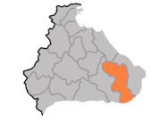
Kumgang County is a kun
Administrative divisions of North Korea
The administrative divisions of North Korea are organized into three hierarchical levels. Many of the units have equivalents in the system of South Korea. At the highest level are nine provinces, two directly governed cities, and three special administrative divisions. The second-level divisions...
, or county, in Kangwon province, North Korea
North Korea
The Democratic People’s Republic of Korea , , is a country in East Asia, occupying the northern half of the Korean Peninsula. Its capital and largest city is Pyongyang. The Korean Demilitarized Zone serves as the buffer zone between North Korea and South Korea...
. Kumgang lies immediately north of the Korean Demilitarized Zone
Korean Demilitarized Zone
The Korean Demilitarized Zone is a strip of land running across the Korean Peninsula that serves as a buffer zone between North and South Korea. The DMZ cuts the Korean Peninsula roughly in half, crossing the 38th parallel on an angle, with the west end of the DMZ lying south of the parallel and...
. It was formed in 1952 from portions of Hoeyang
Hoeyang
Hoeyang is a kun, or county, in Kangwon province, North Korea. It was established in a general reorganization of local government in 1952....
, Yanggu
Yanggu
Yanggu may refer to;*Yanggu County, Shandong , of Liaocheng, Shandong, China*Yanggu, Gangwon , county of Gangwon Province, South Korea...
, and Inje, as part of a general reorganization of local government, and stretches out from north to south. The county takes its name from the Kumgang mountain, which is partially located there.
The Taebaek Mountains
Taebaek Mountains
The Taebaek Mountains are a mountain range in both North Korea and South Korea. They form the main ridge of the Korean peninsula.-Geography:...
pass through the county, reaching their highest point in the Pirobong peak of Kumgangsan. Approximately 85% of the county's area is forestland. Major local streams include the Kumgangchon and Dongkumgangchon.
The chief local industry is agriculture, with rice and maize the dominant crops. However, arable land takes up only 8.5% of the county's area. Manufacturing and livestock raising also contribute to the local economy. Mining is supported by deposits of gold, tungsten, and quartz.
See also
- Geography of North KoreaGeography of North KoreaNorth Korea is located in east Asia on the northern half of the Korean Peninsula. North Korea shares a border with three states, including China along the Amnok River, Russia along the Duman River, and South Korea along the Korean Demilitarized Zone...
- Administrative divisions of North KoreaAdministrative divisions of North KoreaThe administrative divisions of North Korea are organized into three hierarchical levels. Many of the units have equivalents in the system of South Korea. At the highest level are nine provinces, two directly governed cities, and three special administrative divisions. The second-level divisions...
- Kangwon (North Korea)
- KumgangsanKumgangsanKŭmgangsan , Geumgangsan, or Mount Geumgang is a -high mountain in Kangwon-do, North Korea. Its name means "a firm heart in the face of truth". It is about 50 km away from South Korea's Sokcho in Gangwon-do. It is one of the best-known mountains in North Korea...