

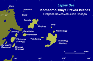
Komsomolskaya Pravda Islands
Encyclopedia
Tundra
In physical geography, tundra is a biome where the tree growth is hindered by low temperatures and short growing seasons. The term tundra comes through Russian тундра from the Kildin Sami word tūndâr "uplands," "treeless mountain tract." There are three types of tundra: Arctic tundra, alpine...
vegetation, shingle
Shingle beach
A shingle beach is a beach which is armoured with pebbles or small- to medium-sized cobbles. Typically, the stone composition may grade from characteristic sizes ranging from two to 200 mm diameter....
and ice. They were known as Ostrova Samuila before the 1917 Russian Revolution and then they were renamed after Komsomolskaya Pravda
Komsomolskaya Pravda
Komsomolskaya Pravda is a daily Russian tabloid newspaper, founded on March 13th, 1925. It is published by "Izdatelsky Dom Komsomolskaya Pravda" .- History :...
, being for a while the only island group in the world named after a newspaper. This situation lasted only until the Izvesti Tsik Islands were given their name after newspaper Izvestia
Izvestia
Izvestia is a long-running high-circulation daily newspaper in Russia. The word "izvestiya" in Russian means "delivered messages", derived from the verb izveshchat . In the context of newspapers it is usually translated as "news" or "reports".-Origin:The newspaper began as the News of the...
. The original name of the islands, "Samuila", was retained for one of the islands of the group though.
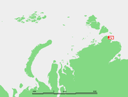
These islands are located in the Laptev Sea
Laptev Sea
The Laptev Sea is a marginal sea of the Arctic Ocean. It is located between the northern coast of Siberia, the Taimyr Peninsula, Severnaya Zemlya and the New Siberian Islands. Its northern boundary passes from the Arctic Cape to a point with co-ordinates of 79°N and 139°E, and ends at the Anisiy...
coastal region, off the mouth of the Simsa Bay
Simsa Bay
The Simsa Bay or Bay of Sims is a gulf in the Laptev Sea on the coast of the Taymyr Peninsula. It measures about 40 km from the mouth of the Gol'tsovaya River in the west to its broadest opening to the sea in the east. Its average width is 14 km.The cluster of islands deep inside the bay...
in the Taymyr Peninsula
Taymyr Peninsula
The Taymyr Peninsula is a peninsula in the Far North of Russia, in the Siberian Federal District, that forms the northernmost part of mainland Eurasia and Asia...
. This island group belongs to the Krasnoyarsk Krai
Krasnoyarsk Krai
Krasnoyarsk Krai is a federal subject of Russia . It is the second largest federal subject after the Sakha Republic, and Russia's largest krai, occupying an area of , which is 13% of the country's total territory. The administrative center of the krai is the city of Krasnoyarsk...
administrative division of Russia
Russia
Russia or , officially known as both Russia and the Russian Federation , is a country in northern Eurasia. It is a federal semi-presidential republic, comprising 83 federal subjects...
.
The largest islands are Ostrov Samuila and Ostrov Bol'shoy (also known as Ostrov Stolovidnyy). Both of them belong to the offshore subgroup, which geographically is sometimes referred to as the proper Komsomolskaya Pravda Islands. The strait between these islands is known as Proliv Diksonskikh Gidrografov (Hydrographer Dikson Strait).
The smaller islands that are located close to the coast at the mouth of the Simsa Bay
Simsa Bay
The Simsa Bay or Bay of Sims is a gulf in the Laptev Sea on the coast of the Taymyr Peninsula. It measures about 40 km from the mouth of the Gol'tsovaya River in the west to its broadest opening to the sea in the east. Its average width is 14 km.The cluster of islands deep inside the bay...
: Udobnyy, Vilkitsky (or Srednyy), Kraynyy (also known as Sliyaniye) and small Kuropachiy (known also as "Avanpost" and "Forpost") , form another subgroup that is also known as the Vilkitsky Islands (Ostrova Vil'kitskogo). These are named after geographer Boris Vilkitsky
Boris Vilkitsky
Boris Andreyevich Vilkitsky was a Russian hydrographer and surveyor. He was the son of Andrey Ippolitovich Vilkitsky....
and should not be confused with the Vilkitski (or Dzhekman) Islands that are part of the Nordenskjold Archipelago or with other islands also called "Vilkitsky".
Uzbekistan Island, named after the former Uzbek Soviet Socialist Republic, has an intermediate position between the two subgroups of the Komsomolskaya Pravda Islands.
Just around the corner of the NE point of the nearby mainland lies small Fram Island (Oстров Фрама; Ostrov Frama), which was named after Norwegian
Norway
Norway , officially the Kingdom of Norway, is a Nordic unitary constitutional monarchy whose territory comprises the western portion of the Scandinavian Peninsula, Jan Mayen, and the Arctic archipelago of Svalbard and Bouvet Island. Norway has a total area of and a population of about 4.9 million...
explorer Fridtjof Nansen
Fridtjof Nansen
Fridtjof Wedel-Jarlsberg Nansen was a Norwegian explorer, scientist, diplomat, humanitarian and Nobel Peace Prize laureate. In his youth a champion skier and ice skater, he led the team that made the first crossing of the Greenland interior in 1888, and won international fame after reaching a...
's ship Fram
Fram
Fram is a ship that was used in expeditions of the Arctic and Antarctic regions by the Norwegian explorers Fridtjof Nansen, Otto Sverdrup, Oscar Wisting, and Roald Amundsen between 1893 and 1912...
.
The climate in these islands and the surrounding waters is extremely severe with frequent gales and blizzards in the winter. The sea surrounding these Islands is covered with fast ice most of the year and is obstructed by pack ice even in the summer.
History
In 1933 the newly-formed Glavsevmorput' (Chief Administration of the Northern Sea RouteChief Directorate of the Northern Sea Route
The Chief Directorate of the Northern Sea Route , also known as Glavsevmorput, was a Soviet government organization in charge of the naval Northern Sea Route, established in January 1932 and dissolved in 1964.-History:The organization traces its roots to AO Komseveroput, a shipping company...
) dispatched the first convoy of freighters via the Northern Sea Route
Northern Sea Route
The Northern Sea Route is a shipping lane officially defined by Russian legislation from the Atlantic Ocean to the Pacific Ocean specifically running along the Russian Arctic coast from Murmansk on the Barents Sea, along Siberia, to the Bering Strait and Far East. The entire route lies in Arctic...
to the mouth of the Lena
Lena River
The Lena is the easternmost of the three great Siberian rivers that flow into the Arctic Ocean . It is the 11th longest river in the world and has the 9th largest watershed...
to deliver cargoes bound for the Yakut ASSR. It consisted of three freighters and was escorted by the icebreaker Krasin
Krasin (icebreaker)
The Krasin is a Russian icebreaker. The vessel operates in polar regions.-History:The ship was built at the Helsinki New Shipyard in Helsinki, Finland in 1976.-Design:...
. Despite heavy ice conditions in the Kara Sea two of the ships reached Tiksi
Tiksi
Tiksi is an urban locality and the administrative center of Bulunsky District of the Sakha Republic, Russia, situated on the Arctic Ocean coast. Population: It is one of the principal ports for accessing the Laptev Sea...
, their destination, and unloaded their cargoes. The third ship, Pravda
Steamer Pravda
Steamer Pravda was a Soviet merchant freighter of about 3,100 tonnes displacement, which was active in the Soviet Arctic during the 1930s. This ship had been normally used for carrying timber. It was named after Soviet newspaper Pravda....
was bound for Bukhta Nordvik
Nordvik
Nordvik is a former municipality in Nordland county, Norway.It was created by a split from Herøy on 1 July 1917. At that time Nordvik had a population of 1,530.On 1 January 1962 Nordvik became a part of the new municipality Dønna...
with an oil exploration expedition. Despite warnings, Pravda ran aground near its destination and turned back.
Severe ice conditions in the Vilkitsky Strait
Vilkitsky Strait
Vilkitsky Strait is a strait between the Taimyr Peninsula and Bolshevik Island in the Severnaya Zemlya archipelago. The strait connects the Kara and Laptev Seas. The length of the Vilkitsky Strait is 104 km, the width – approx. 55 km, and the depth – between 32 and 210 m. It is...
(between Severnaya Zemlya
Severnaya Zemlya
Severnaya Zemlya is an archipelago in the Russian high Arctic at around . It is located off mainland Siberia's Taymyr Peninsula across the Vilkitsky Strait...
and Cape Chelyuskin
Cape Chelyuskin
Cape Chelyuskin is the northernmost point of the Eurasian continent , and the northernmost point of mainland Russia. It is situated at the tip of the Taymyr Peninsula, south of Severnaya Zemlya archipelago, in Krasnoyarsk Krai, Russia...
), forced the three freighters of the convoy, the Pravda, the Volodarskiy
Steamer Volodarskiy
Steamer Volodarskiy was a Soviet freighter of about 3,100 tonnes displacement which was active in the Arctic during the 1930s. This ship had been normally used for carrying timber.The Volodarskiy was named after V...
and the Tovarich Stalin
Steamer Tovarich Stalin
Steamer Tovarishch Stalin was a Soviet freighter of about 3,100 tonnes displacement, active in the Arctic during the 1930s....
to winter at Ostrov Samuila in the Komsomolskaya Pravda Islands. A shore station was built and a full scientific programme maintained all winter by N. N. Urvantsev
Nikolay Urvantsev
Nikolay Nikolayevich Urvantsev was a Soviet geologist and explorer. He was born in the town of Lukoyanov of Nizhny Novgorod Governorate, Russian Empire to the family of a merchant...
and his wife, Dr. Yelizaveta Ivanovna. Urvantsev used the base to explore the Taymyr Peninsula
Taymyr Peninsula
The Taymyr Peninsula is a peninsula in the Far North of Russia, in the Siberian Federal District, that forms the northernmost part of mainland Eurasia and Asia...
.
These ships were released in the following year by Icebreaker Feodor Litke
Icebreaker Feodor Litke
The icebreaker Fyodor Litke was active in the Soviet era in the Arctic, until the late 1950s. It was built in 1909 in England for the Saint Lawrence River service and initially named CGC Earl Grey after Albert Grey, Governor General of Canada...
. Battering heavily the ice around the Komsomolskaya Pravda Islands for one week, the Feodor Litke finally succeeded in breaking the freighters free after carving a 10 km channel with so much effort that its hull suffered grievous damage.
See also
- Laptev SeaLaptev SeaThe Laptev Sea is a marginal sea of the Arctic Ocean. It is located between the northern coast of Siberia, the Taimyr Peninsula, Severnaya Zemlya and the New Siberian Islands. Its northern boundary passes from the Arctic Cape to a point with co-ordinates of 79°N and 139°E, and ends at the Anisiy...
- Vasili PronchishchevVasili PronchishchevVasili Vasilyevich Pronchishchev was a Russian explorer.In 1718, Vasili Pronchishchev graduated from Moscow School of Mathematics and Navigation and was promoted to naval cadet...