
Kolubara River
Encyclopedia
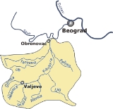
The Kolubara is the 123 km-long river in western Serbia
; it is the eastern tributary to the Sava river.
mountain under the Medvednik peak. It flows to the north, next to the village of Bobova, bends to the west (in this part the river is also known as Jadar), and at the city of Valjevo
, it meets the river Jablanica from the south and forms the Kolubara, as the river is known for the remaining course. The Obnica is 25 km long.
The Jablanica also originates from the Povlen mountain, just few kilometers away from the Obnica, under the Jablanik peak. It curves around the Parač mountain and next to the village of Balinović, before it meets the Obnica at Valjevo. The Jablanica is 24 km long.
This is also the beginning of the 90 km long region of the Kolubara valley, divided in two large parts, referred to as Upper (gornja) Kolubara and Lower (donja) Kolubara (around the Belgrade
's suburb of Obrenovac
).
of Serbia.
, from the left. Due to the floods, even though its valley is densely populated, there are no settlements on the river itself, until it reaches Obrenovac, few kilometers before it empties into the Sava (only navigable near its mouth in Sava). However, many large villages and towns are located in the vicinity of the Kolubara: Lajkovac
, Jabučje
, Lazarevac
, Šopić
, Skobalj, Vreoci
, Mali Borak, Veliki Crljeni
, Draževac, Mislođin
and Barič
, where it flows into the Sava.
Lower Kolubara itself is divided in two sub-regions, the (upper) Kolubara coal basin and the (lower) Obrenovac micro-region.
, the region of Kolubara was a huge bay of the Pannonian Sea
(Kolubarski zaliv) As a result of abundant vegetation in the ancient sea, region of Kolubara and neighboring Tamnava (around Kolubara's longest tributary) today are immense lignite
field which covers over 1.200 km². It is estimated that coal deposits are as much as 4 billion tons, with coal layers being to 50 m deep, and over 20 million tons of coal are being extracted each year. Major mines are Rudovci, Kolubara (at Veliki Crljeni) and Kosmaj, with many surface digs being developed lately.
A series of coal based power stations are built in the basin, including Kolubara (130 MW, at Veliki Crljeni), Nikola Tesla
B-1 (in 1983) and Nikola Tesla B-2 (both 615 MW, in Obrenovac).
Because of its importance for industry and economy in general, the municipality of Lazarevac, to which the coal basin mainly belongs, was attached administratively to the City of Belgrade in 1971.
After three years, on September 19, 2007 the river course between Vreoci and Veliki Crljeni was transferred to the new artificial river bed. This will allow the opening of a new surface coal field Veliki Crljeni in September 2008 with an estimated coal reserves of over 30 million tons.
drainage basin
.
The river is not navigable, but its valley is very important for transportation. Here are located Belgrade-Valjevo road, parts of Belgrade-Šabac
road, Ibarska magistrala (Highway of Ibar
) and the Belgrade-Bar railway.
The Kolubara was the site of one of the major battles on the Balkans
in the World War I
, the Battle of Kolubara
in 1914.
Serbia
Serbia , officially the Republic of Serbia , is a landlocked country located at the crossroads of Central and Southeast Europe, covering the southern part of the Carpathian basin and the central part of the Balkans...
; it is the eastern tributary to the Sava river.
Origin
The Kolubara originates as the Obnica, in the Podgorina region of the western Serbia, on the PovlenPovlen
Povlen is a mountain in western Serbia, located thirty kilometers west of Valjevo. It has several peaks, the three most important being Small Povlen , Middle Povlen and Big Povlen ....
mountain under the Medvednik peak. It flows to the north, next to the village of Bobova, bends to the west (in this part the river is also known as Jadar), and at the city of Valjevo
Valjevo
Valjevo is a city and municipality located in western Serbia. It is the center of the Kolubara District, which includes five other smaller municipalities with a total population of almost 180,000 people...
, it meets the river Jablanica from the south and forms the Kolubara, as the river is known for the remaining course. The Obnica is 25 km long.
The Jablanica also originates from the Povlen mountain, just few kilometers away from the Obnica, under the Jablanik peak. It curves around the Parač mountain and next to the village of Balinović, before it meets the Obnica at Valjevo. The Jablanica is 24 km long.
This is also the beginning of the 90 km long region of the Kolubara valley, divided in two large parts, referred to as Upper (gornja) Kolubara and Lower (donja) Kolubara (around the Belgrade
Belgrade
Belgrade is the capital and largest city of Serbia. It is located at the confluence of the Sava and Danube rivers, where the Pannonian Plain meets the Balkans. According to official results of Census 2011, the city has a population of 1,639,121. It is one of the 15 largest cities in Europe...
's suburb of Obrenovac
Obrenovac
Obrenovac is a town and municipality located in Serbia at 44°40′ North, 20°13′ East. Its name stems from last name "Obrenović" which in turn stems from name "Obren" in Serbian language. In 2003 the municipality has total population of 75,949...
).
Upper Kolubara
At Valjevo, the Kolubara receives the river Gradac from the right and forms the Valjevo valley between the surrounding mountains, in which it spills in several parallel flows. After Valjevo, the most populous city in western Serbia, there are no major settlements on the river, except for the villages of Mlađevo and Slovac and the river receives the right tributaries of Ribnjača and Lepenica and the left tributary of Rabas . At Slovac, near the confluence of the right tributary of the Toplica, the Kolubara carved the epigenetic Slovačka sutjeska , which separates Upper and Lower Kolubara. Upper Kolubara constitutes most of the modern Kolubara DistrictKolubara District
The Kolubara District occupies the central part of western Serbia. It has a population of 174,228...
of Serbia.
Lower Kolubara
The Kolubara turns north and continues to flow in several parallel flows, receiving in this section its major tributaries: Ljig River, Turija, Lukavica and Peštan, from the right; Kladnica and TamnavaTamnava
The Tamnava is a river in western Serbia. It is 90 km long left tributary of the Kolubara River and also gives the name to the surrounding region of Tamnava.- Origin :...
, from the left. Due to the floods, even though its valley is densely populated, there are no settlements on the river itself, until it reaches Obrenovac, few kilometers before it empties into the Sava (only navigable near its mouth in Sava). However, many large villages and towns are located in the vicinity of the Kolubara: Lajkovac
Lajkovac
Lajkovac is a small town and municipality in Serbia, close to the town of Lazarevac.It is located in the Kolubara River valley and near to Ibar highway, the main route from Serbia to Montenegro....
, Jabučje
Jabucje
Jabučje is a village in Pivara municipality in Kragujevac city district in the Šumadija District of central Serbia.It has a population of 154.-External links:*...
, Lazarevac
Lazarevac
Lazarevac is a town and municipality located in Serbia at 44.22° North, 20.15° East. Its name stems from name of medieval Prince Lazar Hrebeljanovic. In 2002 the town has total population of 23,551. Lazarevac is one of Belgrade's 17 municipalities....
, Šopić
Šopić
Lapovo is a village situated in Lazarevac municipality in Serbia....
, Skobalj, Vreoci
Vreoci
Vreoci is a suburban neighborhood in Belgrade, Serbia. It is located in Belgrade's municipality of Lazarevac....
, Mali Borak, Veliki Crljeni
Veliki Crljeni
Veliki Crljeni is a suburban settlement of Belgrade, the capital of Serbia. It is situated in the Lazarevac municipality. The population of the settlement is 4,580 people . There is a thermal power plant Kolubara A, with large coal field, which provides most of the employment for its citizens....
, Draževac, Mislođin
Mislođin
Mislođin is a village situated in Obrenovac municipality in Serbia....
and Barič
Barič
Barič is a village situated in Obrenovac municipality in Serbia....
, where it flows into the Sava.
Lower Kolubara itself is divided in two sub-regions, the (upper) Kolubara coal basin and the (lower) Obrenovac micro-region.
Kolubara coal basin
In NeogeneNeogene
The Neogene is a geologic period and system in the International Commission on Stratigraphy Geologic Timescale starting 23.03 ± 0.05 million years ago and ending 2.588 million years ago...
, the region of Kolubara was a huge bay of the Pannonian Sea
Pannonian Sea
The Pannonian Sea was a shallow ancient sea located in the area today known as the Pannonian Plain in Central Europe. The Pannonian Sea existed during the Miocene and Pliocene epochs, when three to four kilometres of marine sediments were deposited in the Pannonian Basin.-History:The Pannonian Sea...
(Kolubarski zaliv) As a result of abundant vegetation in the ancient sea, region of Kolubara and neighboring Tamnava (around Kolubara's longest tributary) today are immense lignite
Lignite
Lignite, often referred to as brown coal, or Rosebud coal by Northern Pacific Railroad,is a soft brown fuel with characteristics that put it somewhere between coal and peat...
field which covers over 1.200 km². It is estimated that coal deposits are as much as 4 billion tons, with coal layers being to 50 m deep, and over 20 million tons of coal are being extracted each year. Major mines are Rudovci, Kolubara (at Veliki Crljeni) and Kosmaj, with many surface digs being developed lately.
A series of coal based power stations are built in the basin, including Kolubara (130 MW, at Veliki Crljeni), Nikola Tesla
Nikola Tesla
Nikola Tesla was a Serbian-American inventor, mechanical engineer, and electrical engineer...
B-1 (in 1983) and Nikola Tesla B-2 (both 615 MW, in Obrenovac).
Because of its importance for industry and economy in general, the municipality of Lazarevac, to which the coal basin mainly belongs, was attached administratively to the City of Belgrade in 1971.
After three years, on September 19, 2007 the river course between Vreoci and Veliki Crljeni was transferred to the new artificial river bed. This will allow the opening of a new surface coal field Veliki Crljeni in September 2008 with an estimated coal reserves of over 30 million tons.
Characteristics
Due to the lots of long tributaries which create branchy system within the river's drainage area, the short Kolubara drains relatively large area of 3.639 km². It belongs to the Black SeaBlack Sea
The Black Sea is bounded by Europe, Anatolia and the Caucasus and is ultimately connected to the Atlantic Ocean via the Mediterranean and the Aegean seas and various straits. The Bosphorus strait connects it to the Sea of Marmara, and the strait of the Dardanelles connects that sea to the Aegean...
drainage basin
Drainage basin
A drainage basin is an extent or an area of land where surface water from rain and melting snow or ice converges to a single point, usually the exit of the basin, where the waters join another waterbody, such as a river, lake, reservoir, estuary, wetland, sea, or ocean...
.
The river is not navigable, but its valley is very important for transportation. Here are located Belgrade-Valjevo road, parts of Belgrade-Šabac
Šabac
Šabac is a city and municipality in western Serbia, along the Sava river, in the historic region of Mačva. It is the administrative center of the Mačva District. The city has a population of 52,822 , while population of the municipality is 115,347...
road, Ibarska magistrala (Highway of Ibar
Ibar River
The Ibar is a river that flows through eastern Montenegro and Serbia, with a total length of . The river begins in the Hajla mountain, eastern Montenegro, passes through Kosovo and flows into the West Morava river, Central Serbia, near Kraljevo....
) and the Belgrade-Bar railway.
The Kolubara was the site of one of the major battles on the Balkans
Balkans
The Balkans is a geopolitical and cultural region of southeastern Europe...
in the World War I
World War I
World War I , which was predominantly called the World War or the Great War from its occurrence until 1939, and the First World War or World War I thereafter, was a major war centred in Europe that began on 28 July 1914 and lasted until 11 November 1918...
, the Battle of Kolubara
Battle of Kolubara
The Battle of Kolubara was a major victory of Serbia over the invading Austro-Hungarian armies during World War I. The invaders were routed, and driven back across the Serbian border....
in 1914.
See also
- List of rivers in Serbia