
Knapton
Encyclopedia
Knapton is a village and a civil parish
in the English
county of Norfolk
. The village is 8.9 miles (14.3 km) south-east of Cromer
, 19.4 miles (31.2 km) north-east of Norwich
and 134 miles (215.7 km) north-east of London
. The village lies 3.5 miles (5.6 km) north-east of the A149
between Kings Lynn and Great Yarmouth
. The nearest railway station is at North Walsham
for the Bittern Line
which runs between Sheringham
, Cromer and Norwich. The nearest airport is Norwich International Airport
.
of 1086 where it is listed under the name ‘Kanapatone’. The tenant in chief was William de Warenne
who was a Norman
aristocrat who fought at the Battle of Hastings
and became great landowners in England
.
an artist famed as a member of the Norwich school. Inside there is a 13th-century font
on three high steps which has a Purbeck marble
bowl and a cover over which dates from 1704. The inscription which is in Greek reads “wash my sins and not my face only” The inscription is a palindrome, reading the same backwards as forwards.. At the back of the church behind the font there are some coffin-lids from the earlier church set into the flags of the floor. The most prominent feature of this church is the roof. The roof was given to the church by a John Smithe in 1504. It is of a double hammerbeam
construction and still retains its original colour. The beams and spandrels are richly carved with three tiers of angels which have outspread wings. More angels are carved on the kingposts and on the wall plate. In niches below the wall supports there are figures with scrolls, shields, symbols or playing musical instruments. The church is a Grade I listed building http://www.imagesofengland.org.uk/details/default.aspx?id=224290.
Civil parish
In England, a civil parish is a territorial designation and, where they are found, the lowest tier of local government below districts and counties...
in the English
England
England is a country that is part of the United Kingdom. It shares land borders with Scotland to the north and Wales to the west; the Irish Sea is to the north west, the Celtic Sea to the south west, with the North Sea to the east and the English Channel to the south separating it from continental...
county of Norfolk
Norfolk
Norfolk is a low-lying county in the East of England. It has borders with Lincolnshire to the west, Cambridgeshire to the west and southwest and Suffolk to the south. Its northern and eastern boundaries are the North Sea coast and to the north-west the county is bordered by The Wash. The county...
. The village is 8.9 miles (14.3 km) south-east of Cromer
Cromer
Cromer is a coastal town and civil parish in north Norfolk, England. The local government authority is North Norfolk District Council, whose headquarters is in Holt Road in the town. The town is situated 23 miles north of the county town, Norwich, and is 4 miles east of Sheringham...
, 19.4 miles (31.2 km) north-east of Norwich
Norwich
Norwich is a city in England. It is the regional administrative centre and county town of Norfolk. During the 11th century, Norwich was the largest city in England after London, and one of the most important places in the kingdom...
and 134 miles (215.7 km) north-east of London
London
London is the capital city of :England and the :United Kingdom, the largest metropolitan area in the United Kingdom, and the largest urban zone in the European Union by most measures. Located on the River Thames, London has been a major settlement for two millennia, its history going back to its...
. The village lies 3.5 miles (5.6 km) north-east of the A149
A149 road
The A149 is a major route in Norfolk, linking Kings Lynn to Great Yarmouth. It runs via the coast rather than on a more direct route such as the A47. The eastern section runs through The Broads.-Kings Lynn to Wells next the Sea:...
between Kings Lynn and Great Yarmouth
Great Yarmouth
Great Yarmouth, often known to locals as Yarmouth, is a coastal town in Norfolk, England. It is at the mouth of the River Yare, east of Norwich.It has been a seaside resort since 1760, and is the gateway from the Norfolk Broads to the sea...
. The nearest railway station is at North Walsham
North Walsham railway station
North Walsham is a railway station in the town of North Walsham in the English county of Norfolk. The station is served by local services operated by National Express East Anglia on the Bittern Line from Norwich to Cromer and Sheringham...
for the Bittern Line
Bittern Line
The Bittern Line is a railway line from Norwich to Cromer then Sheringham in Norfolk, England. It is one of the most scenic in the East of England traversing the Norfolk Broads on its route to the Area of Outstanding Natural Beauty on the North Norfolk Coast. The line is part of the Network Rail...
which runs between Sheringham
Sheringham
Sheringham is a seaside town in Norfolk, England, west of Cromer.The motto of the town, granted in 1953 to the Sheringham Urban District Council, is Mare Ditat Pinusque Decorat, Latin for "The sea enriches and the pine adorns"....
, Cromer and Norwich. The nearest airport is Norwich International Airport
Norwich International Airport
Norwich International Airport , also known as Norwich Airport, is an airport in the City of Norwich within Norfolk, England north of the city centre and on the edge of the city's suburbs....
.
History
Knapton is mentioned in the Domesday BookDomesday Book
Domesday Book , now held at The National Archives, Kew, Richmond upon Thames in South West London, is the record of the great survey of much of England and parts of Wales completed in 1086...
of 1086 where it is listed under the name ‘Kanapatone’. The tenant in chief was William de Warenne
William de Warenne, 1st Earl of Surrey
William de Warenne, 1st Earl of Surrey, Seigneur de Varennes is one of the very few proven Companions of William the Conqueror known to have fought at the Battle of Hastings in 1066...
who was a Norman
Normans
The Normans were the people who gave their name to Normandy, a region in northern France. They were descended from Norse Viking conquerors of the territory and the native population of Frankish and Gallo-Roman stock...
aristocrat who fought at the Battle of Hastings
Battle of Hastings
The Battle of Hastings occurred on 14 October 1066 during the Norman conquest of England, between the Norman-French army of Duke William II of Normandy and the English army under King Harold II...
and became great landowners in England
England
England is a country that is part of the United Kingdom. It shares land borders with Scotland to the north and Wales to the west; the Irish Sea is to the north west, the Celtic Sea to the south west, with the North Sea to the east and the English Channel to the south separating it from continental...
.
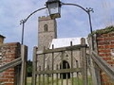
Saint Peter and Saint Paul Parish Church
The present church dates from mainly the 14th century. The tower is set into the north west corner of the building. The porch is on the southern elevation. Atop of the church there is a weathervane designed by J.S. CotmanJohn Sell Cotman
John Sell Cotman was an English marine and landscape painter, etcher, illustrator and author, one of the leading lights of the Norwich school of artists.-Early life and work:...
an artist famed as a member of the Norwich school. Inside there is a 13th-century font
Baptismal font
A baptismal font is an article of church furniture or a fixture used for the baptism of children and adults.-Aspersion and affusion fonts:...
on three high steps which has a Purbeck marble
Purbeck Marble
Purbeck Marble is a fossiliferous limestone quarried in the Isle of Purbeck, a peninsula in south-east Dorset, England.It is one of many kinds of Purbeck Limestone, deposited in the late Jurassic or early Cretaceous periods....
bowl and a cover over which dates from 1704. The inscription which is in Greek reads “wash my sins and not my face only” The inscription is a palindrome, reading the same backwards as forwards.. At the back of the church behind the font there are some coffin-lids from the earlier church set into the flags of the floor. The most prominent feature of this church is the roof. The roof was given to the church by a John Smithe in 1504. It is of a double hammerbeam
Hammerbeam roof
Hammerbeam roof, in architecture, is the name given to an open timber roof, typical of English Gothic architecture, using short beams projecting from the wall.- Design :...
construction and still retains its original colour. The beams and spandrels are richly carved with three tiers of angels which have outspread wings. More angels are carved on the kingposts and on the wall plate. In niches below the wall supports there are figures with scrolls, shields, symbols or playing musical instruments. The church is a Grade I listed building http://www.imagesofengland.org.uk/details/default.aspx?id=224290.