
Kisdon
Encyclopedia
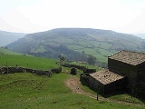
Kisdon, also called Kisdon Hill is a fell
situated in upper Swaledale
in the Yorkshire Dales National Park
in North Yorkshire
, England
.
when the moraine
left by the retreating glacier
blocked the original course of the River Swale
on the west side of the fell and diverted it to its present course, forming a gorge to the east of the fell and leaving Kisdon isolated from other high ground. Kisdon’s isolation gives it the status of a Marilyn
even though it only has a modest height of 499 metres (1636 feet).
Another unusual feature of Kisdon is that it has no official footpath to the highest point even though it is crossed by two busy rights of way high up on the fell. One of these is the Pennine Way
on its way between the hamlets of Thwaite and Keld
which reaches a height of 420 metres on the eastern shoulder of the fell, while the bridleway between Keld and Muker
also known as the Old Corpse Road because it was formerly used to transport bodies for burial in consecrated ground lower down the valley crosses the fell on the western side at a height of 470 metres. Kisdon lies within a band of Yoredale limestone, it is on Kisdon that the band attains its maximum thickness of 40 metres.
, although the highest point does seem a few metres east of it. 100 metres east of the summit is a five metre deep shake hole
which is marked on the Ordnance Survey
map as a pot hole, so the depression may go much deeper on closer investigation.
The grass and heather covered summit gives a good all round view with the bulk of Rogan's Seat
including the great gash of Swinner Gill dominating to the east while Great Shunner Fell
and Lovely Seat
with the Buttertubs Pass in between show well to the south west. To conclude the day walkers can descend easterly to the Pennine Way and take in the impressive waterfalls around Keld, namely Kisdon Force
, East Gill Force
, Catrake Force
and Wain Wath Force
.
(SSSI) over an area of 3.7 hectares since 1988. The SSSI takes the form of four grazed enclosures with the combination of Calcareous
grassland growing on limestone rock supporting exceptional and varied botanical species. The steepest of the enclosures has a considerable population of Juniperus communis
which has survived since the last Ice age
and appears to be regenerating. Other species include blue moor grass, flea sedge
, limestone bedstraw
, Early Purple Orchid
and Primula vulgaris
amongst others.
Fell
“Fell” is a word used to refer to mountains, or certain types of mountainous landscape, in Scandinavia, the Isle of Man, and parts of northern England.- Etymology :...
situated in upper Swaledale
Swaledale
Swaledale is one of the northernmost dales in the Yorkshire Dales National Park in northern England. It is the dale of the River Swale on the east side of the Pennines in North Yorkshire.-Geographical overview:...
in the Yorkshire Dales National Park
Yorkshire Dales
The Yorkshire Dales is the name given to an upland area in Northern England.The area lies within the historic county boundaries of Yorkshire, though it spans the ceremonial counties of North Yorkshire, West Yorkshire and Cumbria...
in North Yorkshire
North Yorkshire
North Yorkshire is a non-metropolitan or shire county located in the Yorkshire and the Humber region of England, and a ceremonial county primarily in that region but partly in North East England. Created in 1974 by the Local Government Act 1972 it covers an area of , making it the largest...
, England
England
England is a country that is part of the United Kingdom. It shares land borders with Scotland to the north and Wales to the west; the Irish Sea is to the north west, the Celtic Sea to the south west, with the North Sea to the east and the English Channel to the south separating it from continental...
.
Geography and history
Kisdon was named by early Norse settlers and it has Kisdon Farm on its southern slopes above Straw Beck. The Fell is unusual in that it is an isolated area of high ground with no connecting ridges to other fells. This came about at the end of the last Ice ageIce age
An ice age or, more precisely, glacial age, is a generic geological period of long-term reduction in the temperature of the Earth's surface and atmosphere, resulting in the presence or expansion of continental ice sheets, polar ice sheets and alpine glaciers...
when the moraine
Moraine
A moraine is any glacially formed accumulation of unconsolidated glacial debris which can occur in currently glaciated and formerly glaciated regions, such as those areas acted upon by a past glacial maximum. This debris may have been plucked off a valley floor as a glacier advanced or it may have...
left by the retreating glacier
Glacier
A glacier is a large persistent body of ice that forms where the accumulation of snow exceeds its ablation over many years, often centuries. At least 0.1 km² in area and 50 m thick, but often much larger, a glacier slowly deforms and flows due to stresses induced by its weight...
blocked the original course of the River Swale
River Swale
The River Swale is a river in Yorkshire, England and a major tributary of the River Ure, which itself becomes the River Ouse, emptying into the North Sea via the Humber Estuary....
on the west side of the fell and diverted it to its present course, forming a gorge to the east of the fell and leaving Kisdon isolated from other high ground. Kisdon’s isolation gives it the status of a Marilyn
Marilyn (hill)
A Marilyn is a mountain or hill in the United Kingdom, Republic of Ireland or Isle of Man with a relative height of at least 150 metres , regardless of absolute height or other merit...
even though it only has a modest height of 499 metres (1636 feet).
Another unusual feature of Kisdon is that it has no official footpath to the highest point even though it is crossed by two busy rights of way high up on the fell. One of these is the Pennine Way
Pennine Way
The Pennine Way is a National Trail in England. The trail runs from Edale, in the northern Derbyshire Peak District, north through the Yorkshire Dales and the Northumberland National Park and ends at Kirk Yetholm, just inside the Scottish border. The path runs along the Pennine hills, sometimes...
on its way between the hamlets of Thwaite and Keld
Keld, North Yorkshire
Keld is a hamlet in the English county of North Yorkshire. It is situated on Swaledale, in the Yorkshire Dales. The name derives from the Viking word Kelda meaning a spring, and the village was once called Appletre Kelde - the spring near the apple trees.Keld is the crossing point of the Coast to...
which reaches a height of 420 metres on the eastern shoulder of the fell, while the bridleway between Keld and Muker
Muker
Muker is a village and civil parish in the Richmondshire district of North Yorkshire, England. Situated in Swaledale, one of the Yorkshire Dales, its name...
also known as the Old Corpse Road because it was formerly used to transport bodies for burial in consecrated ground lower down the valley crosses the fell on the western side at a height of 470 metres. Kisdon lies within a band of Yoredale limestone, it is on Kisdon that the band attains its maximum thickness of 40 metres.
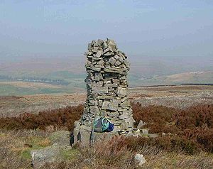
Ascent and summit
The fell is crossed by many high wire topped dry stone walls which can make attaining the highest point of the fell awkward and this should be borne in mind when planning an ascent. Routes to the summit can be started at Muker, Thwaite or Keld and the bridleway should be used to attain the summit plateau where it joins a high wall which can be followed northerly to the summit of the fell which is marked by a substantial cairnCairn
Cairn is a term used mainly in the English-speaking world for a man-made pile of stones. It comes from the or . Cairns are found all over the world in uplands, on moorland, on mountaintops, near waterways and on sea cliffs, and also in barren desert and tundra areas...
, although the highest point does seem a few metres east of it. 100 metres east of the summit is a five metre deep shake hole
Sinkhole
A sinkhole, also known as a sink, shake hole, swallow hole, swallet, doline or cenote, is a natural depression or hole in the Earth's surface caused by karst processes — the chemical dissolution of carbonate rocks or suffosion processes for example in sandstone...
which is marked on the Ordnance Survey
Ordnance Survey
Ordnance Survey , an executive agency and non-ministerial government department of the Government of the United Kingdom, is the national mapping agency for Great Britain, producing maps of Great Britain , and one of the world's largest producers of maps.The name reflects its creation together with...
map as a pot hole, so the depression may go much deeper on closer investigation.
The grass and heather covered summit gives a good all round view with the bulk of Rogan's Seat
Rogan's Seat
Rogan's Seat is a remote hill located near East Stonesdale and Gunnerside Gill, in the Yorkshire Dales in England.It is a high expanse of moorland that stretches alongside Swaledale, Swinner Gill and Gunnerside Gill...
including the great gash of Swinner Gill dominating to the east while Great Shunner Fell
Great Shunner Fell
Great Shunner Fell is the third highest mountain in the Yorkshire Dales, North Yorkshire, England, and the highest point in Wensleydale; at 716 metres above sea level.The Pennine Way passes over its summit, on the way from Hawes to Keld...
and Lovely Seat
Lovely Seat
Lovely Seat is a fell in the Yorkshire Dales National Park in North Yorkshire, England which reaches a height of 675 metres . It is situated at grid reference five kilometres north of the town of Hawes, and is part of the high ground which separates Wensleydale from Swaledale. It is the highest...
with the Buttertubs Pass in between show well to the south west. To conclude the day walkers can descend easterly to the Pennine Way and take in the impressive waterfalls around Keld, namely Kisdon Force
Kisdon Force
Kisdon Force is a series of waterfalls on the River Swale in Swaledale, England. The falls are situated at grid reference within the Yorkshire Dales National Park in the county of North Yorkshire, 500 metres downstream from the small hamlet of Keld....
, East Gill Force
East Gill Force
East Gill Force is a waterfalls in Swaledale, 300 metres to the east of the hamlet of Keld, in the Yorkshire Dales National Park, North Yorkshire, England. The falls are located on East Gill at grid reference , just before its confluence with the River Swale at the point where the Pennine Way and...
, Catrake Force
Catrake Force
Catrake Force is a waterfall on the river Swale in North Yorkshire, England. It is not visible from the road but only a short walk to reach it. It comprises a series of 4 steps each its own small waterfall and each with a very different character with the largest single drop being about .It lies on...
and Wain Wath Force
Wain Wath Force
Wain Wath Force is a waterfall situated on the River Swale in the Yorkshire Dales National Park, North Yorkshire, England. The falls are located at grid reference , one kilometre upstream from the hamlet of Keld which has three other waterfalls in its vicinity, namely Kisdon Force, East Gill Force...
.
Scar Closes, Kisdon Side SSSI
The western side of Kisdon has been designated as a Site of Special Scientific InterestSite of Special Scientific Interest
A Site of Special Scientific Interest is a conservation designation denoting a protected area in the United Kingdom. SSSIs are the basic building block of site-based nature conservation legislation and most other legal nature/geological conservation designations in Great Britain are based upon...
(SSSI) over an area of 3.7 hectares since 1988. The SSSI takes the form of four grazed enclosures with the combination of Calcareous
Calcareous
Calcareous is an adjective meaning mostly or partly composed of calcium carbonate, in other words, containing lime or being chalky. The term is used in a wide variety of scientific disciplines.-In zoology:...
grassland growing on limestone rock supporting exceptional and varied botanical species. The steepest of the enclosures has a considerable population of Juniperus communis
Juniperus communis
Juniperus communis, the Common Juniper, is a species in the genus Juniperus, in the family Cupressaceae. It has the largest range of any woody plant, throughout the cool temperate Northern Hemisphere from the Arctic south in mountains to around 30°N latitude in North America, Europe and Asia.-...
which has survived since the last Ice age
Ice age
An ice age or, more precisely, glacial age, is a generic geological period of long-term reduction in the temperature of the Earth's surface and atmosphere, resulting in the presence or expansion of continental ice sheets, polar ice sheets and alpine glaciers...
and appears to be regenerating. Other species include blue moor grass, flea sedge
Carex
Carex is a genus of plants in the family Cyperaceae, commonly known as sedges. Other members of the Cyperaceae family are also called sedges, however those of genus Carex may be called "true" sedges, and it is the most species-rich genus in the family. The study of Carex is known as...
, limestone bedstraw
Galium
Galium is a large genus of annual and perennial herbaceous plants in the family Rubiaceae, with 617 known species occurring in the temperate zones of both the Northern and Southern Hemispheres. Most species are known as bedstraw. G...
, Early Purple Orchid
Early Purple Orchid
Orchis mascula, the Early Purple Orchid, is a species of orchid in the genus Orchis.-Etymology:The specific name is derived from the Latin "masculus", meaning "male" or "virile" and it should refer to the robust aspect of this species or to the shape of the tubers, similar to a pair of...
and Primula vulgaris
Primula vulgaris
Primula vulgaris is a species of Primula native to western and southern Europe , northwest Africa , and southwest Asia...
amongst others.