
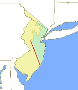
Border between West Jersey and East Jersey
Encyclopedia
Province of New Jersey
The Province of New Jersey was one of the Middle Colonies of Colonial America and became the U.S. state of New Jersey in 1776. The province had originally been settled by Europeans as part of New Netherland, but came under English rule after the surrender of Fort Amsterdam in 1664, becoming a...
was formally separated into two provinces, West Jersey
West Jersey
West Jersey and East Jersey were two distinct parts of the Province of New Jersey. The political division existed for 28 years, between 1674 and 1702...
and East Jersey
East Jersey
The Province of East Jersey and the Province of West Jersey were two distinct, separately governed parts of the Province of New Jersey that existed as separate provinces for 28 years, between 1674 and 1702. East Jersey's capital was located at Perth Amboy...
, for the 28 years between 1674 and 1702.
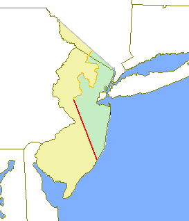
Determination of an exact location for a West Jersey/East Jersey borderline was often a matter of dispute. The southern point of all of the lines is well north of Atlantic City
Atlantic City, New Jersey
Atlantic City is a city in Atlantic County, New Jersey, United States, and a nationally renowned resort city for gambling, shopping and fine dining. The city also served as the inspiration for the American version of the board game Monopoly. Atlantic City is located on Absecon Island on the coast...
, making the land occupied by that city part of West Jersey, though this may seem surprising since Atlantic City is on the east coast.
Remnants of the most operative line — the Keith Line
Keith line
The Keith line was a line drawn through the Province of New Jersey, dividing it into the Province of West Jersey and the Province of East Jersey. The line was created by Surveyor-General George Keith in 1686, when he ran the first survey to mark out the border between West Jersey and East Jersey...
(marked by George Keith
George Keith
George Keith was a Scottish missionary.-Life:Born in Peterhead, Aberdeenshire, Scotland, to a Presbyterian family, he received an M.A. from the University of Aberdeen...
) — can still be seen in the county boundaries between Burlington
Burlington County, New Jersey
There were 154,371 households out of which 34.30% had children under the age of 18 living with them, 57.70% were married couples living together, 10.90% had a female householder with no husband present, and 27.70% were non-families. 22.90% of all households were made up of individuals and 8.50% had...
and Ocean
Ocean County, New Jersey
-Demographics:As of the census of 2000, there were 510,916 people, 200,402 households, and 137,876 families residing in the county. The population density was 803 people per square mile . There were 248,711 housing units at an average density of 151/km²...
and between Hunterdon
Hunterdon County, New Jersey
Hunterdon County is a county located in the western section of the U.S. state of New Jersey. As of the 2010 United States Census, the population was 128,349. It is part of the New York Metropolitan Area. Its county seat is Flemington....
and Somerset
Somerset County, New Jersey
Somerset County is a county located in the U.S. state of New Jersey. In 2010, the population was 323,444. It is part of the New York Metropolitan Area. Its county seat is Somerville....
, as well as in a number of municipal boundaries within Mercer
Mercer County, New Jersey
As of the census of 2000, there were 350,761 people, 125,807 households, and 86,303 families residing in the county. The population density was 1,552 people per square mile . There were 133,280 housing units at an average density of 590 per square mile...
and Ocean
Ocean County, New Jersey
-Demographics:As of the census of 2000, there were 510,916 people, 200,402 households, and 137,876 families residing in the county. The population density was 803 people per square mile . There were 248,711 housing units at an average density of 151/km²...
counties. The Keith Line runs NNW from the southern part of Little Egg Harbor
Little Egg Harbor Township, New Jersey
Little Egg Harbor Township is a Township in Ocean County, New Jersey, United States. As of the 2010 United States Census, the township population had increased to a record high of 20,065....
, passing just north of Tuckerton
Tuckerton, New Jersey
Tuckerton is a Borough in Ocean County, New Jersey, named for founder Ebenezer Tucker , and was a port of entry, but not the third Port of Entry as commonly believed, in the United States As of the 2000 United States Census, the borough population was 3,517.Tuckerton was incorporated as a borough...
, and proceeding up toward a point on the Delaware River
Delaware River
The Delaware River is a major river on the Atlantic coast of the United States.A Dutch expedition led by Henry Hudson in 1609 first mapped the river. The river was christened the South River in the New Netherland colony that followed, in contrast to the North River, as the Hudson River was then...
just north of the Water Gap
Delaware Water Gap
The Delaware Water Gap is on the border of New Jersey and Pennsylvania where the Delaware River cuts through a large ridge of the Appalachian Mountains...
.
The Keith line did not agree with the deed that formally defined the boundary, the 1676 Quintipartite Deed
Quintipartite Deed
The Quintipartite Deed was a legal document that split the Province of New Jersey, dividing it into the Province of West Jersey and the Province of East Jersey from 1674 until 1702....
, and later, more accurate surveys and maps needed to be made to resolve property disputes. This resulted in the Thornton Line, about 1696, and the Lawrence Line, 1743, which was adopted as the final line for legal purposes.