

Katete
Encyclopedia
Eastern Province, Zambia
Eastern Province is one of Zambia's nine provinces. The province lies between the Luangwa River and the border with Malawi, from Isoka in the northeast to just north of Luangwa in the south.The provincial capital is Chipata...
of Zambia
Zambia
Zambia , officially the Republic of Zambia, is a landlocked country in Southern Africa. The neighbouring countries are the Democratic Republic of the Congo to the north, Tanzania to the north-east, Malawi to the east, Mozambique, Zimbabwe, Botswana and Namibia to the south, and Angola to the west....
, and is headquarters of Katete District
Katete District
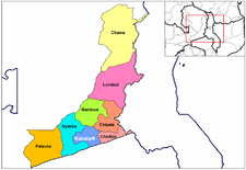
Katete District with headquarters at Katete in Eastern Province, Zambia, includes woodland in the north sloping down into the Luangwa Valley, good farmland amid rocky hills in the centre, and deforested plateau exposed to soil erosion and degradation in the south along the border with Mozambique...
. The town is at the foot of rocky hills which lie to its east, including Mpangwe Hill and Kangarema Hill, which rise to 1600 m and are surrounded by cultivated fields. It lies on the Great East Road
Great East Road (Zambia)
The Great East Road is a major road in Zambia and the only highway linking its Eastern Province with the rest of the country. It is also the major link between Zambia and Malawi and between Zambia and northern Mozambique...
about 90 km south-west of the provincial capital, Chipata
Chipata
Chipata, population 98,416, is the capital of the Eastern Province of Zambia. The two languages spoken are Nyanja and English, though you might find some Indian languages, as there is a large number of Zambian Indians located in the town...
at an elevation of 1060 m on the watershed
Water divide
A drainage divide, water divide, divide or watershed is the line separating neighbouring drainage basins...
between the middle Luangwa River
Luangwa River
The Luangwa River is one of the major tributaries of the Zambezi River, and one of the four biggest rivers of Zambia. The river generally floods in the rainy season and then falls considerably in the dry season...
and the Zambezi
Zambezi
The Zambezi is the fourth-longest river in Africa, and the largest flowing into the Indian Ocean from Africa. The area of its basin is , slightly less than half that of the Nile...
. In the town is a major road junction, with a surfaced road branching off and running 50 km to the Mozambique
Mozambique
Mozambique, officially the Republic of Mozambique , is a country in southeastern Africa bordered by the Indian Ocean to the east, Tanzania to the north, Malawi and Zambia to the northwest, Zimbabwe to the west and Swaziland and South Africa to the southwest...
border and connecting with Tete
Tete
-External links:* *...
on the Zambezi
Zambezi
The Zambezi is the fourth-longest river in Africa, and the largest flowing into the Indian Ocean from Africa. The area of its basin is , slightly less than half that of the Nile...
339 km to the south-east.