

Kashmir and Jammu
Encyclopedia
Jammu and Kashmir was, from 1846 until 1947, a princely state
in the British Empire in India, and was ruled by a Maharaja
. The state was created in 1846 when, after its victory in the First Anglo-Sikh War
, the East India Company
annexed the Kashmir valley and immediately sold it to the Dogra
ruler of Jammu
under the Treaty of Amritsar
.
According to the treaty, the state was "situated to the eastward of the river Indus and westward of the river Ravi", and covered an area of 80900 mi2. Later, the regions of Hunza
, Nagar, and Gilgit
were added to the state.
At the time of the partition of India
, the ruler of the state, which was a Muslim
-majority region, vacillated between joining Muslim-majority Pakistan
, Hindu
-majority India
, and remaining independent. After the Indo-Pakistani War of 1947
the region of the princely state became a disputed territory.
Durrani Empire
, until it was annexed by Sikh
s led by Ranjit Singh
. During Sikh rule, Jammu was a tributary of the Sikh Empire.
After the death of the Raja
of Jammu, Kishore Singh, in 1822, his son Gulab Singh was recognised by the Sikhs as his heir. He then, initially under the Sikhs, began expanding his kingdom.
As Raja of Jammu, Gulab Singh conquered Bhadarwah after a slight resistance. He then annexed Kishtwar
after the minister, Wazir Lakhpat, quarrelled with the ruler and sought the assistance of Gulab Singh. The Raja of Kishtwar surrendered without fighting when Gulab Singh's forces arrived. The conquest of Kishtwar meant that Singh had gained control of two of the roads which led into Ladakh
, which then led to the conquest of that territory. Although there were huge difficulties due to the mountains and glaciers, the Dogras under Gulab Singh's officer, Zorawar Singh
, conquered the whole of Ladakh in two campaigns.
A few years later, in 1840, General Zorawar Singh
invaded Baltistan
, captured the Raja of Skardu
, who had sided with the Ladakhis, and annexed his country. The following year (1841) Zorawar Singh, while invading Tibet
, was overtaken by winter and, as a result of being attacked when his troops were disabled by cold, perished with nearly his entire army. Whether it was policy or whether it was accident, by 1840 Gulab Singh had encircled Kashmir.
In the winter of 1845, war broke out between the British and the Sikhs. Gulab Singh remained neutral until the battle of Sobraon
in 1846, when he appeared as a useful mediator and the trusted adviser of Sir Henry Lawrence
. Two treaties were concluded. By the first, the State of Lahore
was handed over to the British, as equivalent to an indemnity of one crore
rupee, the hill countries between the rivers Beas and the Indus; by the second, the British made over to Gulab Singh for 75 lakh
rupees all the hilly or mountainous country situated to the east of the Indus and west of the Ravi.
Rani Jindan's lover and chief minister of the Sikh empire, Lal Singh, who later became the prime minister of the Sikh empire, asked the governor of Kashmir, Imam-Uddin, to resist the force of Dogras, which was going there to replace Sikhs as the newly-founded state. The governor ordered invasion on the Dogra troops, which led to the death of many Dogra troops and general Lakhpat. Furious with the treachery, Gulab Singh, along with British Forces, started to invade the Kashmir, on which Governor Imam-Uddin pleaded mercy, as he claimed that the action had been carried out on orders from Lahore(the capital of the Sikh Empire). Gulab Singh and British forces ousted the governor and appointed Gulab Singh as the new Maharaja of Jammu and Kashmir. For this treachery, Lal Singh faced the wrath of the British Empire. Imam-uddin showed the British and Gulab Singh the documents which had been sent to him by the Sikh Empire, which caused him to attack the Dogra Forces, which were on their way to replace Sikh forces in the Kashmir valley. Lal Singh was removed from the post and also banished from entering the Punjab Region.
Gulab Singh died in 1857; and when his successor, Ranbir Singh
, had recovered from the strain caused by the Indian Rebellion
, in which he had loyally sided with the British, he was determined to recover Gilgit and to expand to the frontier. In 1860 a force under Devi Singh crossed the Indus, and advanced on Gaur Rahman's strong fort at Gilgit. Gaur Rahman had died just before the arrival of the Dogras. The fort was taken and held by the Maharajas of Jammu and Kashmir until 1947.Capturing Gligit was not the last frontier , determine to expand their land they capture the fort of Yasin and Punial however the lack of funds and to make more stronger barrier against Invaders they fell back to Gilgit and hold it till the Independence of Indian Subcontinent from British Rule.
Gulab singh grandson Pratap Singh defeated Ruler of Chitral in 1891 and forces Hunza and Nagar to accept the suzerainty of the Jammu and Kashmir state.
Ranbir Singh although tolerant of other creeds lacked his father's strong will and determination, and his control over the State officials was weak. The latter part of his life was darkened by the dreadful famine in Kashmir, 1877-9; and in September, 1885, he was succeeded: by his eldest son, Maharaja Pratap Singh, G.C.S.I.
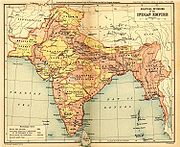 The area of the state extended from 32° 17′ to 36° 58′ N. and from 73° 26′ to 80° 30′ E.. Jammu
was the southern most part of the state and was adjacent to the Punjab districts of Jhelum
, Gujrat
, Sialkot
, and Gurdaspur
. There is just a fringe of level land along the Punjab frontier, bordered by a plinth of low hilly country sparsely wooded, broken, and irregular. This is known as the Kandi, the home of the Chib
s and the Dogra
s. To travel north, a range of mountains 8000 feet (2,438.4 m) high must be climbed. This is a temperate country with forests of oak, rhododendron, chestnut, and higher up, of deodar and pine, a country of beautiful uplands, such as Bbadarwah and Kishtwar, drained by the deep gorge of the Chenab river. The steps of the Himalayan range, known as the Pir Panjal, lead to the second storey, on which rests the exquisite valley of Kashmir, drained by the Jhelum river.
Up steeper flights of the Himalayas led to Astore
and Baltistan
on the north and to Ladakh on the east, a tract drained by the river Indus. In the back premises, faraway to the north-west, lies Gilgit
, west and north of the Indus, the whole area shadowed by a wall of giant mountains which run east from the Kilik or Mintaka passes of the Hindu Kush
, leading to the Pamirs
and the Chinese dominions
past Rakaposhi
(25,561 ft), along the Muztagh
range past K2
(Godwin Austen, 28,265 feet), Gasherbrum
and Masherbrum
(28,100 and 28561 feet (8,705.4 m) respectively) to the Karakoram range which merges in the Kunlun Mountains
. Westward of the northern angle above Hunza
-Nagar the mighty maze of mountains and glaciers trends a little south of east along the Hindu Kush range bordering Chitral, and so on into the limits of Kafiristan and Afghan territory.
to Leh, it was possible to travel from Rawalpindi
via Kohala and over the Kohala Bridge
into Kashmir. The route from Kohala to Srinagar was a cart-road 132 miles (212.4 km) in length, from Kohala to Baramulla
the road was close to the River Jhelum. At Muzaffarabad
the Kishenganga River joins the Jhelum and at this point the road from Abbottabad
and Garhi Habibullah
meet the Kashmir route. The road carried heavy traffic and required expensive maintenance by the authorities to repair.
was passed, this meant that British India would be divided into two independent states, the Dominion of Pakistan
and the Union of India. According to the Act, "the suzerainty
of His Majesty over the Indian States lapses, and with it, all treaties and agreements in force at the date of the passing of this Act between His Majesty and the rulers of Indian States", so each of the princely states would be free to join India or Pakistan or to remain independent. Most of the princes acceded to either of the two nations.
However the ruler of Kashmir wanted to remain independent, neither joining Pakistan or India, this led to war between the two neighbouring countries in which Kashmir became divided between them. Each government believes that the former princely state belongs to them in its entirety; this has led to several wars. The Kashmir conflict
between the two nuclear neighbours remains one of the most intractable and longest running disputes on the United Nations Security Council
's agenda.
The Indian position claims that an Instrument of Accession
to the new India was
executed by Maharajah Hari Singh
, ruler of the state, agreeing to join India on October 26, 1947. This is disputed by other parties, and India has failed to produce this Instrument of Accession
to substantiate it's claims. This was then formally accepted by the Governor-General of India
, but not by Pakistan
because Kashmir had a majority of Muslims.
Princely state
A Princely State was a nominally sovereign entitity of British rule in India that was not directly governed by the British, but rather by an Indian ruler under a form of indirect rule such as suzerainty or paramountcy.-British relationship with the Princely States:India under the British Raj ...
in the British Empire in India, and was ruled by a Maharaja
Maharaja
Mahārāja is a Sanskrit title for a "great king" or "high king". The female equivalent title Maharani denotes either the wife of a Maharaja or, in states where that was customary, a woman ruling in her own right. The widow of a Maharaja is known as a Rajamata...
. The state was created in 1846 when, after its victory in the First Anglo-Sikh War
First Anglo-Sikh War
The First Anglo-Sikh War was fought between the Sikh Empire and the British East India Company between 1845 and 1846. It resulted in partial subjugation of the Sikh kingdom.-Background and causes of the war:...
, the East India Company
East India Company
The East India Company was an early English joint-stock company that was formed initially for pursuing trade with the East Indies, but that ended up trading mainly with the Indian subcontinent and China...
annexed the Kashmir valley and immediately sold it to the Dogra
Dogra
The Dogras are an Indo-Aryan ethnic group in South Asia. Being a diversified group, the Dogras include both Savarnas such as Brahmins, Rajputs and Non-savarnas. The Dogras also incluide merchant castes such as Mahajans...
ruler of Jammu
Jammu
Jammu , also known as Duggar, is one of the three administrative divisions within Jammu and Kashmir, the northernmost state in India.Jammu city is the largest city in Jammu and the winter capital of Jammu and Kashmir...
under the Treaty of Amritsar
Treaty of Amritsar
The Treaty of Amritsar was signed on March 16, 1846, to settle a dispute over territory in Kashmir after the First Sikh War with the United Kingdom, ceding some land to Maharaja Gulab Singh Dogra...
.
According to the treaty, the state was "situated to the eastward of the river Indus and westward of the river Ravi", and covered an area of 80900 mi2. Later, the regions of Hunza
Hunza
Hunza may refer to*Hunza Valley*Former State of Hunza*Hunza River*Hunza Peak*Hunza people*Hunza is the Muisca name of the city of Tunja, Colombia...
, Nagar, and Gilgit
Gilgit
Gilgit is a city in northern PakistanGilgit may refer to other terms related with the area of the city:* Gilgit River* Gilgit Valley* Gilgit District* Gilgit Agency * Gilgit Airport...
were added to the state.
At the time of the partition of India
Partition of India
The Partition of India was the partition of British India on the basis of religious demographics that led to the creation of the sovereign states of the Dominion of Pakistan and the Union of India on 14 and 15...
, the ruler of the state, which was a Muslim
Muslim
A Muslim, also spelled Moslem, is an adherent of Islam, a monotheistic, Abrahamic religion based on the Quran, which Muslims consider the verbatim word of God as revealed to prophet Muhammad. "Muslim" is the Arabic term for "submitter" .Muslims believe that God is one and incomparable...
-majority region, vacillated between joining Muslim-majority Pakistan
Pakistan
Pakistan , officially the Islamic Republic of Pakistan is a sovereign state in South Asia. It has a coastline along the Arabian Sea and the Gulf of Oman in the south and is bordered by Afghanistan and Iran in the west, India in the east and China in the far northeast. In the north, Tajikistan...
, Hindu
Hindu
Hindu refers to an identity associated with the philosophical, religious and cultural systems that are indigenous to the Indian subcontinent. As used in the Constitution of India, the word "Hindu" is also attributed to all persons professing any Indian religion...
-majority India
India
India , officially the Republic of India , is a country in South Asia. It is the seventh-largest country by geographical area, the second-most populous country with over 1.2 billion people, and the most populous democracy in the world...
, and remaining independent. After the Indo-Pakistani War of 1947
Indo-Pakistani War of 1947
The India-Pakistan War of 1947-48, sometimes known as the First Kashmir War, was fought between India and Pakistan over the princely state of Kashmir and Jammu from 1947 to 1948. It was the first of four wars fought between the two newly independent nations...
the region of the princely state became a disputed territory.
Creation
Prior to the creation of the princely state, Kashmir was ruled by the PashtunPashtun people
Pashtuns or Pathans , also known as ethnic Afghans , are an Eastern Iranic ethnic group with populations primarily between the Hindu Kush mountains in Afghanistan and the Indus River in Pakistan...
Durrani Empire
Durrani Empire
The Durrani Empire was a Pashtun dynasty centered in Afghanistan and included northeastern Iran, the Kashmir region, the modern state of Pakistan, and northwestern India. It was established at Kandahar in 1747 by Ahmad Shah Durrani, an Afghan military commander under Nader Shah of Persia and chief...
, until it was annexed by Sikh
Sikh
A Sikh is a follower of Sikhism. It primarily originated in the 15th century in the Punjab region of South Asia. The term "Sikh" has its origin in Sanskrit term शिष्य , meaning "disciple, student" or शिक्ष , meaning "instruction"...
s led by Ranjit Singh
Ranjit Singh
Maharaja Ranjit Singh Ji was the first Maharaja of the Sikh Empire.-Early life:...
. During Sikh rule, Jammu was a tributary of the Sikh Empire.
After the death of the Raja
Raja
Raja is an Indian term for a monarch, or princely ruler of the Kshatriya varna...
of Jammu, Kishore Singh, in 1822, his son Gulab Singh was recognised by the Sikhs as his heir. He then, initially under the Sikhs, began expanding his kingdom.
As Raja of Jammu, Gulab Singh conquered Bhadarwah after a slight resistance. He then annexed Kishtwar
Kishtwar
Kishtwar is a town and a notified area committee in Kishtwar District in Jammu and Kashmir, the northernmost state of India.-Geography:Kishtwar is located at...
after the minister, Wazir Lakhpat, quarrelled with the ruler and sought the assistance of Gulab Singh. The Raja of Kishtwar surrendered without fighting when Gulab Singh's forces arrived. The conquest of Kishtwar meant that Singh had gained control of two of the roads which led into Ladakh
Ladakh
Ladakh is a region of Jammu and Kashmir, the northernmost state of the Republic of India. It lies between the Kunlun mountain range in the north and the main Great Himalayas to the south, inhabited by people of Indo-Aryan and Tibetan descent...
, which then led to the conquest of that territory. Although there were huge difficulties due to the mountains and glaciers, the Dogras under Gulab Singh's officer, Zorawar Singh
General Zorawar Singh
Zorawar Singh Kahluria was born in a village of Kahlur State in modern Himachal Pradesh, India....
, conquered the whole of Ladakh in two campaigns.
A few years later, in 1840, General Zorawar Singh
General Zorawar Singh
Zorawar Singh Kahluria was born in a village of Kahlur State in modern Himachal Pradesh, India....
invaded Baltistan
Baltistan
Baltistan , also known as بلتیول བལིུལ་ in the Balti language, is a region in northern Pakistan which forms Gilgit-Baltistan, bordering the Xinjiang Autonomous Region of China. In addition, a part of Baltistan also falls into Jammu and Kashmir of India. It is situated in the Karakoram mountains...
, captured the Raja of Skardu
Skardu
Skardu , is the main town of the region Baltistan and the capital of Skardu District, one of the districts making up Pakistan's Gilgit Baltistan....
, who had sided with the Ladakhis, and annexed his country. The following year (1841) Zorawar Singh, while invading Tibet
Tibet
Tibet is a plateau region in Asia, north-east of the Himalayas. It is the traditional homeland of the Tibetan people as well as some other ethnic groups such as Monpas, Qiang, and Lhobas, and is now also inhabited by considerable numbers of Han and Hui people...
, was overtaken by winter and, as a result of being attacked when his troops were disabled by cold, perished with nearly his entire army. Whether it was policy or whether it was accident, by 1840 Gulab Singh had encircled Kashmir.
In the winter of 1845, war broke out between the British and the Sikhs. Gulab Singh remained neutral until the battle of Sobraon
Battle of Sobraon
The Battle of Sobraon was fought on 10 February 1846, between the forces of the British East India Company and the Sikh Khalsa Army, the army of the Sikh Empire of the Punjab...
in 1846, when he appeared as a useful mediator and the trusted adviser of Sir Henry Lawrence
Henry Montgomery Lawrence
Sir Henry Montgomery Lawrence was a British soldier and statesman in India, who died defending Lucknow during the Indian Mutiny.-Career:Lawrence was the brother of John Lawrence, 1st Baron Lawrence and was born at Matara, Ceylon...
. Two treaties were concluded. By the first, the State of Lahore
Lahore
Lahore is the capital of the Pakistani province of Punjab and the second largest city in the country. With a rich and fabulous history dating back to over a thousand years ago, Lahore is no doubt Pakistan's cultural capital. One of the most densely populated cities in the world, Lahore remains a...
was handed over to the British, as equivalent to an indemnity of one crore
Crore
A crore is a unit in the Indian number system equal to ten million , or 100 lakhs. It is widely used in India, Bangladesh, Nepal, and Pakistan....
rupee, the hill countries between the rivers Beas and the Indus; by the second, the British made over to Gulab Singh for 75 lakh
Lakh
A lakh is a unit in the Indian numbering system equal to one hundred thousand . It is widely used both in official and other contexts in Pakistan, Bangladesh, India, Maldives, Nepal, Sri Lanka, Myanmar and is often used in Indian English.-Usage:...
rupees all the hilly or mountainous country situated to the east of the Indus and west of the Ravi.
Rani Jindan's lover and chief minister of the Sikh empire, Lal Singh, who later became the prime minister of the Sikh empire, asked the governor of Kashmir, Imam-Uddin, to resist the force of Dogras, which was going there to replace Sikhs as the newly-founded state. The governor ordered invasion on the Dogra troops, which led to the death of many Dogra troops and general Lakhpat. Furious with the treachery, Gulab Singh, along with British Forces, started to invade the Kashmir, on which Governor Imam-Uddin pleaded mercy, as he claimed that the action had been carried out on orders from Lahore(the capital of the Sikh Empire). Gulab Singh and British forces ousted the governor and appointed Gulab Singh as the new Maharaja of Jammu and Kashmir. For this treachery, Lal Singh faced the wrath of the British Empire. Imam-uddin showed the British and Gulab Singh the documents which had been sent to him by the Sikh Empire, which caused him to attack the Dogra Forces, which were on their way to replace Sikh forces in the Kashmir valley. Lal Singh was removed from the post and also banished from entering the Punjab Region.
Kings of Kashmir and Jammu
| S.no | Name | Reign |
|---|---|---|
| 1. | Gulab Singh | 1846 - 1857 |
| 2. | Ranbir Singh Ranbir Singh General Shriman Rajrajeshwar Maharajadhiraj Sri Sir Ranbir Singhji, Indar Mahindar Bahadur, Sipar-i-Sultanat, Mushir-i-Khas-i-Kaiser-i-Hind GCSI, CIE, Kaiser-i-Hind was the son of Maharaja Gulab Singh, Maharaja of Jammu and Kashmir and head of the Jamwal Rajput clan.The trans-Himalayan territories... |
1857 - 1885 |
| 3. | Pratap Singh Partab Singh of Kashmir Pratap Singh was the Maharaja of Jammu and Kashmir, and head of the Jamwal Rajput clan.Some elements in the British Empire made an attempt to implicate the Dogra Maharaja in a conspiracy case involving the Russian Empire... |
1885 - 1925 |
| 4. | Hari Singh Hari Singh Maharaja Hari Singh was the last ruling Maharaja of the princely state of Jammu and Kashmir in India.He was married four times... |
1925 - 1949 |
Expansion
Not long afterwards the Hunza Raja, attacked Gilgit territory. Nathu Shah on behalf of Gulab Singh responded by leading a force to attack the Hunza valley; he and his force were destroyed, and Gilgit fort fell into the hands of the Hunza Raja, along with Punial, Yasin, and Darel. The Maharaja then sent two columns, one from Astor and one from Baltistan, and after some fighting Gilgit fort was recovered. In 1852 the Dogra troops were annihilated by Gaur Rahman of Yasin, and for eight years the Indus formed the boundary of the Maharaja's territories.Gulab Singh died in 1857; and when his successor, Ranbir Singh
Ranbir Singh
General Shriman Rajrajeshwar Maharajadhiraj Sri Sir Ranbir Singhji, Indar Mahindar Bahadur, Sipar-i-Sultanat, Mushir-i-Khas-i-Kaiser-i-Hind GCSI, CIE, Kaiser-i-Hind was the son of Maharaja Gulab Singh, Maharaja of Jammu and Kashmir and head of the Jamwal Rajput clan.The trans-Himalayan territories...
, had recovered from the strain caused by the Indian Rebellion
Indian Rebellion of 1857
The Indian Rebellion of 1857 began as a mutiny of sepoys of the British East India Company's army on 10 May 1857, in the town of Meerut, and soon escalated into other mutinies and civilian rebellions largely in the upper Gangetic plain and central India, with the major hostilities confined to...
, in which he had loyally sided with the British, he was determined to recover Gilgit and to expand to the frontier. In 1860 a force under Devi Singh crossed the Indus, and advanced on Gaur Rahman's strong fort at Gilgit. Gaur Rahman had died just before the arrival of the Dogras. The fort was taken and held by the Maharajas of Jammu and Kashmir until 1947.Capturing Gligit was not the last frontier , determine to expand their land they capture the fort of Yasin and Punial however the lack of funds and to make more stronger barrier against Invaders they fell back to Gilgit and hold it till the Independence of Indian Subcontinent from British Rule.
Gulab singh grandson Pratap Singh defeated Ruler of Chitral in 1891 and forces Hunza and Nagar to accept the suzerainty of the Jammu and Kashmir state.
Ranbir Singh although tolerant of other creeds lacked his father's strong will and determination, and his control over the State officials was weak. The latter part of his life was darkened by the dreadful famine in Kashmir, 1877-9; and in September, 1885, he was succeeded: by his eldest son, Maharaja Pratap Singh, G.C.S.I.
Geography
Jammu
Jammu , also known as Duggar, is one of the three administrative divisions within Jammu and Kashmir, the northernmost state in India.Jammu city is the largest city in Jammu and the winter capital of Jammu and Kashmir...
was the southern most part of the state and was adjacent to the Punjab districts of Jhelum
Jhelum District
Jhelum District is in the Punjab province of Pakistan. According the 1998 census the district had a population of 936,957, of which 31.48% were urban. Jhelum is known for providing a large number of soldiers to the British and later to the Pakistan armed forces due to which it is also known as...
, Gujrat
Gujrat District
Gujrat is a district of Punjab Province in Pakistan. It is an ancient district located in between two famous rivers, the Jhelum and Chenab. Because of its proximity with the rivers the land is good for cultivation with rice and sugar cane as main crops...
, Sialkot
Sialkot District
Sialkot District or the District of Sialkot , is one of the districts of the Punjab province of Pakistan. It is located in the north-east of the province...
, and Gurdaspur
Gurdaspur District
Gurdaspur district is a district in the state of Punjab, situated in the northwest part of the Republic of India. Gurdaspur is the district headquarters. It internationally borders Narowal District of the Pakistani Punjab, Kathua District of Jammu and Kashmir, the Punjab districts of Amritsar and...
. There is just a fringe of level land along the Punjab frontier, bordered by a plinth of low hilly country sparsely wooded, broken, and irregular. This is known as the Kandi, the home of the Chib
Chib
The Chib Rajput , is a Chandravanshi Rajput clan found in the northern parts of India and Pakistan. They are mostly a Kashmiri or Punjabi tribe found in both India and Pakistan...
s and the Dogra
Dogra
The Dogras are an Indo-Aryan ethnic group in South Asia. Being a diversified group, the Dogras include both Savarnas such as Brahmins, Rajputs and Non-savarnas. The Dogras also incluide merchant castes such as Mahajans...
s. To travel north, a range of mountains 8000 feet (2,438.4 m) high must be climbed. This is a temperate country with forests of oak, rhododendron, chestnut, and higher up, of deodar and pine, a country of beautiful uplands, such as Bbadarwah and Kishtwar, drained by the deep gorge of the Chenab river. The steps of the Himalayan range, known as the Pir Panjal, lead to the second storey, on which rests the exquisite valley of Kashmir, drained by the Jhelum river.
Up steeper flights of the Himalayas led to Astore
Astore Valley
Astore Valley is now located in Astore District in the autonomous Pakistani regions of Gilgit-Baltistan,previously in the princely state of Jammu and Kashmir. The valley, adjoining the eastern side of mountain Nanga Parbat, is about long, having area of .The entrance of the valley is located...
and Baltistan
Baltistan
Baltistan , also known as بلتیول བལིུལ་ in the Balti language, is a region in northern Pakistan which forms Gilgit-Baltistan, bordering the Xinjiang Autonomous Region of China. In addition, a part of Baltistan also falls into Jammu and Kashmir of India. It is situated in the Karakoram mountains...
on the north and to Ladakh on the east, a tract drained by the river Indus. In the back premises, faraway to the north-west, lies Gilgit
Gilgit
Gilgit is a city in northern PakistanGilgit may refer to other terms related with the area of the city:* Gilgit River* Gilgit Valley* Gilgit District* Gilgit Agency * Gilgit Airport...
, west and north of the Indus, the whole area shadowed by a wall of giant mountains which run east from the Kilik or Mintaka passes of the Hindu Kush
Hindu Kush
The Hindu Kush is an mountain range that stretches between central Afghanistan and northern Pakistan. The highest point in the Hindu Kush is Tirich Mir in the Chitral region of Khyber-Pakhtunkhwa, Pakistan.It is the westernmost extension of the Pamir Mountains, the Karakoram Range, and is a...
, leading to the Pamirs
Pamir Mountains
The Pamir Mountains are a mountain range in Central Asia formed by the junction or knot of the Himalayas, Tian Shan, Karakoram, Kunlun, and Hindu Kush ranges. They are among the world’s highest mountains and since Victorian times they have been known as the "Roof of the World" a probable...
and the Chinese dominions
China
Chinese civilization may refer to:* China for more general discussion of the country.* Chinese culture* Greater China, the transnational community of ethnic Chinese.* History of China* Sinosphere, the area historically affected by Chinese culture...
past Rakaposhi
Rakaposhi
Rakaposhi , is a mountain in the Karakoram mountain range in Pakistan. It is situated in the Nagar Valley approximately 100 km north of the city of Gilgit in the Gilgit District of the Gilgit-Baltistan province of Pakistan. Rakaposhi means "Snow Covered" in the local language. Rakaposhi is...
(25,561 ft), along the Muztagh
Muztagh
Muztagh may refer to:The Greater Karakoram ranges*Baltoro Muztagh*Batura Muztagh*Hispar Muztagh*Panmah Muztagh*Rimo Muztagh*Saser Muztagh*Siachen MuztaghTwo mountain passes in the Karakoram, the western and the eastern*Mustagh PassesThe Mountains...
range past K2
K2
K2 is the second-highest mountain on Earth, after Mount Everest...
(Godwin Austen, 28,265 feet), Gasherbrum
Gasherbrum
Gasherbrum is a remote group of peaks located at the northeastern end of the Baltoro Glacier in the Karakoram range of the Himalaya on the border of the Chinese Shaksgam Valley and the Gilgit-Baltistan territory of Pakistan. The massif contains three of the world's 8,000 metre peaks...
and Masherbrum
Masherbrum
Masherbrum is located in the Gilgit Baltistan of Pakistan. At it is the 22nd highest mountain in the world and the 9th highest in Pakistan. It was the first scaled and mapped peak in the Karakoram mountain range, hence its name....
(28,100 and 28561 feet (8,705.4 m) respectively) to the Karakoram range which merges in the Kunlun Mountains
Kunlun Mountains
The Kunlun Mountains are one of the longest mountain chains in Asia, extending more than 3,000 km. In the broadest sense, it forms the northern edge of the Tibetan Plateau south of the Tarim Basin and the Gansu Corridor and continues east south of the Wei River to end at the North China Plain.The...
. Westward of the northern angle above Hunza
Hunza (princely state)
Hunza was a princely state in the northernmost part of the Northern Areas of Pakistan until 1974. The state was also known as Kanjut. The state bordered the Gilgit Agency to the south, the former princely state of Nagar to the east, China, to the north and Afghanistan to the northwest. The state...
-Nagar the mighty maze of mountains and glaciers trends a little south of east along the Hindu Kush range bordering Chitral, and so on into the limits of Kafiristan and Afghan territory.
Transport
There used to be a route from KohalaKohala, Pakistan
Kohala is a town in Pakistan on the River Jhelum, north of Murree, south of Muzaffarabad, and east of Circle Bakote. -Location:...
to Leh, it was possible to travel from Rawalpindi
Rawalpindi
Rawalpindi , locally known as Pindi, is a city in the Pothohar region of Pakistan near Pakistan's capital city of Islamabad, in the province of Punjab. Rawalpindi is the fourth largest city in Pakistan after Karachi, Lahore and Faisalabad...
via Kohala and over the Kohala Bridge
Kohala Bridge
The Kohala Bridge across the Jhelum River, a tributary of the Indus River, forms part of one of the land routes from the Azad Kashmir to the rest of Pakistan....
into Kashmir. The route from Kohala to Srinagar was a cart-road 132 miles (212.4 km) in length, from Kohala to Baramulla
Baramulla
Baramulla , known as Varahamula in antiquity, is a city in the Baramulla district in Jammu and Kashmir state in northern India...
the road was close to the River Jhelum. At Muzaffarabad
Muzaffarabad
Muzaffarabad is the capital of Pakistan Occupied Kashmir, Pakistan. It is located in Muzaffarabad District on the banks of the Jhelum and Neelum rivers...
the Kishenganga River joins the Jhelum and at this point the road from Abbottabad
Abbottabad
Abbottabad is a city located in the Hazara region of the Khyber Pakhtunkhwa province, in Pakistan. The city is situated in the Orash Valley, northeast of the capital Islamabad and east of Peshawar at an altitude of and is the capital of the Abbottabad District...
and Garhi Habibullah
Garhi Habibullah
Garhi Habibullah is a town and union council of Mansehra District in the Khyber-Pakhtunkhwa province of Pakistan. It is located in Mansehra Tehsil and lies to the east of the district capital Mansehra, towards the Kashmir frontier . It is in an area affected by the 2005 Kashmir...
meet the Kashmir route. The road carried heavy traffic and required expensive maintenance by the authorities to repair.
Flooding
In 1893, after 52 hours of continuous rain, very serious flooding took place in the Jhelum and much damage was done to Srinagar. The floods of 1903 were much more severe.End of the princely state
In 1947 the Indian Independence ActIndian Independence Act 1947
The Indian Independence Act 1947 was as an Act of the Parliament of the United Kingdom that partitioned British India into the two new independent dominions of India and Pakistan...
was passed, this meant that British India would be divided into two independent states, the Dominion of Pakistan
Dominion of Pakistan
The Dominion of Pakistan was an independent federal Commonwealth realm in South Asia that was established in 1947 on the partition of British India into two sovereign dominions . The Dominion of Pakistan, which included modern-day Pakistan and Bangladesh, was intended to be a homeland for the...
and the Union of India. According to the Act, "the suzerainty
Suzerainty
Suzerainty occurs where a region or people is a tributary to a more powerful entity which controls its foreign affairs while allowing the tributary vassal state some limited domestic autonomy. The dominant entity in the suzerainty relationship, or the more powerful entity itself, is called a...
of His Majesty over the Indian States lapses, and with it, all treaties and agreements in force at the date of the passing of this Act between His Majesty and the rulers of Indian States", so each of the princely states would be free to join India or Pakistan or to remain independent. Most of the princes acceded to either of the two nations.
However the ruler of Kashmir wanted to remain independent, neither joining Pakistan or India, this led to war between the two neighbouring countries in which Kashmir became divided between them. Each government believes that the former princely state belongs to them in its entirety; this has led to several wars. The Kashmir conflict
Kashmir conflict
The Kashmir conflict is a territorial dispute between India and Pakistan over the Kashmir region, the northwesternmost region of South Asia....
between the two nuclear neighbours remains one of the most intractable and longest running disputes on the United Nations Security Council
United Nations Security Council
The United Nations Security Council is one of the principal organs of the United Nations and is charged with the maintenance of international peace and security. Its powers, outlined in the United Nations Charter, include the establishment of peacekeeping operations, the establishment of...
's agenda.
The Indian position claims that an Instrument of Accession
Instrument of Accession (Jammu and Kashmir)
The Instrument of Accession is a legal document executed by Maharajah Hari Singh, ruler of the princely state of Jammu and Kashmir, on 26 October 1947...
to the new India was
executed by Maharajah Hari Singh
Hari Singh
Maharaja Hari Singh was the last ruling Maharaja of the princely state of Jammu and Kashmir in India.He was married four times...
, ruler of the state, agreeing to join India on October 26, 1947. This is disputed by other parties, and India has failed to produce this Instrument of Accession
Instrument of Accession (Jammu and Kashmir)
The Instrument of Accession is a legal document executed by Maharajah Hari Singh, ruler of the princely state of Jammu and Kashmir, on 26 October 1947...
to substantiate it's claims. This was then formally accepted by the Governor-General of India
Governor-General of India
The Governor-General of India was the head of the British administration in India, and later, after Indian independence, the representative of the monarch and de facto head of state. The office was created in 1773, with the title of Governor-General of the Presidency of Fort William...
, but not by Pakistan
Pakistan
Pakistan , officially the Islamic Republic of Pakistan is a sovereign state in South Asia. It has a coastline along the Arabian Sea and the Gulf of Oman in the south and is bordered by Afghanistan and Iran in the west, India in the east and China in the far northeast. In the north, Tajikistan...
because Kashmir had a majority of Muslims.
See also
- The Royal House of Jammu and KashmirThe Royal House of Jammu and KashmirThe Royal House of Jammu and Kashmir trace their roots to the mythical Ikshvaku Dynasty of Northern India, Lord Rama is the 'kuldevta' of the Dogras....
- Azad KashmirAzad KashmirAzad Jammu and Kashmir or Azad Kashmir for short, is the southernmost political entity within the Pakistani-administered part of the former princely state of Jammu and Kashmir...
- Jammu and KashmirJammu and KashmirJammu and Kashmir is the northernmost state of India. It is situated mostly in the Himalayan mountains. Jammu and Kashmir shares a border with the states of Himachal Pradesh and Punjab to the south and internationally with the People's Republic of China to the north and east and the...
- Kashmir conflictKashmir conflictThe Kashmir conflict is a territorial dispute between India and Pakistan over the Kashmir region, the northwesternmost region of South Asia....
- Kashmir region