
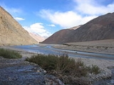
Karakash River
Encyclopedia
The Karakash or Black Jade River, also spelled Karakax ' onMouseout='HidePop("45581")' href="/topics/Pinyin">pinyin
: Hēiyù hé), is a river in the Xinjiang
autonomous region of the People's Republic of China
, which lies partially in the disputed Aksai Chin
region. The river originates near Sumde on the northern slopes of the Karakoram
range in the Aksai Chin
region of the historical Jammu and Kashmir
region. It flows north to Sumnal (15,540 ft), then turns sharply northeastwards (skirting the Soda Plains of Aksai Chin) until just beyond Palong Karpo, when it turns sharply northwestwards, and crosses into Xinjiang
proper. It flows past the towns of Sumgal, Fotash, Gulbashem, until it reaches Xaidulla
.
The river then turns sharply northeastwards again near Xaidulla
, and, after passing through Ali Nazar crosses the Kunlun
mountain range near the Suget or Sanju Pass
, passing east of Khotan, running parallel to the Yurungkash River, which it joins near Koxlax (some 200 km north of Khotan, 38.08°N 80.56°E), from where it continues north as the Khotan River
passing Piqanlik (40.05°N 80.89°E), and seasonally crossing the desert, joining the Tarim River
at 42°29′N 80°56′E.
The Karakash River is famous for its white and greenish jade
(nephrite
) carried as river boulders and pebbles toward Khotan
, as does the nearby Yurungkash (or 'White Jade') River. This river jade originates from eroded mountain deposits of which the most famous one is near, Gulbashen, in southwestern Xinjiang (formerly Chinese Turkestan).
The Karakash Valley was also a caravan road for the north-south trade between Yarkand (China
) and Leh over the Karakoram Pass
in Leh District
of Jammu and Kashmir
.
Pinyin
Pinyin is the official system to transcribe Chinese characters into the Roman alphabet in China, Malaysia, Singapore and Taiwan. It is also often used to teach Mandarin Chinese and spell Chinese names in foreign publications and used as an input method to enter Chinese characters into...
: Hēiyù hé), is a river in the Xinjiang
Xinjiang
Xinjiang is an autonomous region of the People's Republic of China. It is the largest Chinese administrative division and spans over 1.6 million km2...
autonomous region of the People's Republic of China
People's Republic of China
China , officially the People's Republic of China , is the most populous country in the world, with over 1.3 billion citizens. Located in East Asia, the country covers approximately 9.6 million square kilometres...
, which lies partially in the disputed Aksai Chin
Aksai Chin
Aksai Chin is one of the two main disputed border areas between China and India, and the other is South Tibet, which comprises most of India's Arunachal Pradesh. It is administered by China as part of Hotan County in the Hotan Prefecture of Xinjiang Autonomous Region, but is also claimed by India...
region. The river originates near Sumde on the northern slopes of the Karakoram
Karakoram
The Karakoram, or Karakorum , is a large mountain range spanning the borders between Pakistan, India and China, located in the regions of Gilgit-Baltistan , Ladakh , and Xinjiang region,...
range in the Aksai Chin
Aksai Chin
Aksai Chin is one of the two main disputed border areas between China and India, and the other is South Tibet, which comprises most of India's Arunachal Pradesh. It is administered by China as part of Hotan County in the Hotan Prefecture of Xinjiang Autonomous Region, but is also claimed by India...
region of the historical Jammu and Kashmir
Jammu and Kashmir
Jammu and Kashmir is the northernmost state of India. It is situated mostly in the Himalayan mountains. Jammu and Kashmir shares a border with the states of Himachal Pradesh and Punjab to the south and internationally with the People's Republic of China to the north and east and the...
region. It flows north to Sumnal (15,540 ft), then turns sharply northeastwards (skirting the Soda Plains of Aksai Chin) until just beyond Palong Karpo, when it turns sharply northwestwards, and crosses into Xinjiang
Xinjiang
Xinjiang is an autonomous region of the People's Republic of China. It is the largest Chinese administrative division and spans over 1.6 million km2...
proper. It flows past the towns of Sumgal, Fotash, Gulbashem, until it reaches Xaidulla
Xaidulla
Xaidulla, Shahidullah or Shahidula is a small settlement or camping ground on the upper Karakash River strategically located just to the north of the Karakoram Pass on the old caravan route from the Tarim Basin to Ladakh...
.
The river then turns sharply northeastwards again near Xaidulla
Xaidulla
Xaidulla, Shahidullah or Shahidula is a small settlement or camping ground on the upper Karakash River strategically located just to the north of the Karakoram Pass on the old caravan route from the Tarim Basin to Ladakh...
, and, after passing through Ali Nazar crosses the Kunlun
Kunlun Mountains
The Kunlun Mountains are one of the longest mountain chains in Asia, extending more than 3,000 km. In the broadest sense, it forms the northern edge of the Tibetan Plateau south of the Tarim Basin and the Gansu Corridor and continues east south of the Wei River to end at the North China Plain.The...
mountain range near the Suget or Sanju Pass
Sanju Pass
The Sanju, or Sanju-la, is a mountain pass in the Kun Lun Mountains in Xinjiang, China. It was the last on a series of difficult passes on the most common summer caravan route between Ladakh and the Tarim Basin....
, passing east of Khotan, running parallel to the Yurungkash River, which it joins near Koxlax (some 200 km north of Khotan, 38.08°N 80.56°E), from where it continues north as the Khotan River
Khotan River
The Khotan River is formed by the union of the White Jade and Black Jade Rivers, which flow north from the Kunlun Mountains into the Taklamakan Desert in northern China. The two rivers unite towards the middle of the desert, some north of the town of Khotan...
passing Piqanlik (40.05°N 80.89°E), and seasonally crossing the desert, joining the Tarim River
Tarim River
The Tarim River is the principal river of the Xinjiang Uygur Autonomous Region in the People's Republic of China...
at 42°29′N 80°56′E.
The Karakash River is famous for its white and greenish jade
Jade
Jade is an ornamental stone.The term jade is applied to two different metamorphic rocks that are made up of different silicate minerals:...
(nephrite
Nephrite
Nephrite is a variety of the calcium and magnesium-rich amphibole mineral actinolite . The chemical formula for nephrite is Ca25Si8O222. It is one of two different mineral species called jade. The other mineral species known as jade is jadeite, which is a variety of pyroxene...
) carried as river boulders and pebbles toward Khotan
Khotan
Hotan , or Hetian , also spelled Khotan, is the seat of the Hotan Prefecture in Xinjiang, China. It was previously known in Chinese as 于窴/於窴 and to 19th-century European explorers as Ilchi....
, as does the nearby Yurungkash (or 'White Jade') River. This river jade originates from eroded mountain deposits of which the most famous one is near, Gulbashen, in southwestern Xinjiang (formerly Chinese Turkestan).
The Karakash Valley was also a caravan road for the north-south trade between Yarkand (China
China
Chinese civilization may refer to:* China for more general discussion of the country.* Chinese culture* Greater China, the transnational community of ethnic Chinese.* History of China* Sinosphere, the area historically affected by Chinese culture...
) and Leh over the Karakoram Pass
Karakoram Pass
The Karakoram Pass is a mountain pass between India and China in the Karakoram Range. It is the highest pass on the ancient caravan route between Leh in Ladakh and Yarkand in the Tarim Basin...
in Leh District
Leh District
Leh is one of the two districts located in Ladakh, the other being the Kargil District to the west, in the state of Jammu and Kashmir, India. It is the second largest district in India in terms of area. It is bounded on the north by Ghanche District , a small border with Xinjiang, China, via the...
of Jammu and Kashmir
Jammu and Kashmir
Jammu and Kashmir is the northernmost state of India. It is situated mostly in the Himalayan mountains. Jammu and Kashmir shares a border with the states of Himachal Pradesh and Punjab to the south and internationally with the People's Republic of China to the north and east and the...
.
See also
- Keriya RiverKeriya RiverThe Keriya River is a river in the province of Xinjiang in China. It flows for from the Kunlun Shan mountain range north into the endorheic Tarim Basin, but is lost in the desert several hundred kilometers south of the Tarim River. The only major settlement along the river is Keriya Town, east of...
- List of rivers in China
- List of rivers in Asia
- Indian subcontinentIndian subcontinentThe Indian subcontinent, also Indian Subcontinent, Indo-Pak Subcontinent or South Asian Subcontinent is a region of the Asian continent on the Indian tectonic plate from the Hindu Kush or Hindu Koh, Himalayas and including the Kuen Lun and Karakoram ranges, forming a land mass which extends...
- Hindu-tagh
- Geography of LadakhGeography of LadakhLadakh is the highest altitude plateau region in India , straddling the Himalayan and Karakoram mountain ranges and the upper Indus River valley....