
Sanju Pass
Encyclopedia

Xinjiang
Xinjiang is an autonomous region of the People's Republic of China. It is the largest Chinese administrative division and spans over 1.6 million km2...
, China. It was the last on a series of difficult passes on the most common summer caravan route between Ladakh
Ladakh
Ladakh is a region of Jammu and Kashmir, the northernmost state of the Republic of India. It lies between the Kunlun mountain range in the north and the main Great Himalayas to the south, inhabited by people of Indo-Aryan and Tibetan descent...
and the Tarim Basin
Tarim Basin
The Tarim Basin is a large endorheic basin occupying an area of about . It is located in the Xinjiang Uyghur Autonomous Region in China's far west. Its northern boundary is the Tian Shan mountain range and its southern is the Kunlun Mountains on the northern edge of the Tibetan Plateau. The...
.
Caravan routes
The main route led from the Nubra ValleyNubra Valley
Nubra Valley is about 150 km north of Leh, the capital town of Ladakh, India. Local scholars say that its original name was Ldumra . The Shyok River meets the Nubra or Siachan River to form a large valley that separates the Ladakh and the Karakoram Ranges. The average altitude of the valley is...
in Ladakh across the ice-covered Sasser Pass
Sasser Pass
Saser Pass, Saser La, or Sasser Pass is a high mountain pass in Ladakh and India on the ancient summer caravan route from Leh in Ladakh to Yarkand in the Tarim Basin...
(5,411 m or 17,753 ft) and the even higher Karakoram Pass
Karakoram Pass
The Karakoram Pass is a mountain pass between India and China in the Karakoram Range. It is the highest pass on the ancient caravan route between Leh in Ladakh and Yarkand in the Tarim Basin...
(5,575 m 18,291 ft) and the relatively easy Suget Pass to the staging post at Shahidulla. From there in summer the caravans normally headed north across the Sanju Pass to modern Guma (Pishan) in the Tarim Basin and then either northwest to Karghalik and Yarkand or northeast to Khotan
Khotan
Hotan , or Hetian , also spelled Khotan, is the seat of the Hotan Prefecture in Xinjiang, China. It was previously known in Chinese as 于窴/於窴 and to 19th-century European explorers as Ilchi....
.
After crossing the Sanju, the caravans descended to the village of Sanju from where a good road led 122 miles (196 km) to Yarkand, meeting up with the Kilian route at Bora and the Kilik and Kugiar routes at Karghalik.
From Shahidula to the Tarim Basin the traveller had a choice of three passes, the Kilik (not to be confused with the Kilik Pass
Kilik Pass
The Kilik Pass , to the west of Mintaka Pass is a high mountain pass in the Karakorum Mountains between Pakistan-administered Kashmir and Xinjiang in the People's Republic of China. The two passes were, in ancient times, the two main access points into the Upper Hunza Valley from the north...
leading from the Hunza Valley
Hunza Valley
The Hunza Valley is a mountainous valley in the Gilgit-Baltistan region of Pakistan. The Hunza valley is situated to the north of the Hunza River, at an elevation of around . The territory of Hunza is about...
to the north), the Kilian Pass and the Sanju; but the usual route for caravans in the 19th century was via the Sanju Pass.
The Kilik Pass was reportedly once frequently used by Balti
Balti people
The Balti are an ethnic group of Tibetan descent with some Dardic admixture located in Gilgit-Baltistan, Pakistan and Ladakh, a region in Jammu & Kashmir, India; as well as scattered in Pakistan's major urban centres of Lahore, Karachi and Islamabad/Rawalpindi. The Balti language belongs to the...
merchants based in Yarkand and had plenty of fodder and fuel at every stage. It was said to be the easiest and shortest route, but merchants were not allowed to use it for political reasons. Travellers were also often prevented from accessing it for considerable periods during hot weather due to flooding of the Toghra about 9 miles (14 km) below Shahidula. After crossing the pass the route joined the Kugiar route at Beshterek, one day's march south of Karghalik.
Apparently, the Kilian was previously the most frequented pass, though it was little used in the 19th century except sometimes in the summer. It is higher than the Sanju Pass and also impractical for laden horses, but reportedly not so difficult to cross. The road then descends to the village of Kilian and, after two marches one reached Bora on the road between Sanju and Karghalik. The summit of the pass is always covered with ice and snow and is not practicable for laden ponies - yaks have to be used.
19th century Kashmiri claim
During the Dungan revolt or Muslim Rebellion which began in 1862, Eastern Turkestan (modern XinjiangXinjiang
Xinjiang is an autonomous region of the People's Republic of China. It is the largest Chinese administrative division and spans over 1.6 million km2...
) became independent of China for almost 15 years. The border between British India
British Raj
British Raj was the British rule in the Indian subcontinent between 1858 and 1947; The term can also refer to the period of dominion...
and the semi-independent State of Kashmir with Eastern Turkestan became a matter of some speculation. According to some sources, the spine of the eastern Congling (Kuenlun) range formed the southern boundary of Khotan
Khotan
Hotan , or Hetian , also spelled Khotan, is the seat of the Hotan Prefecture in Xinjiang, China. It was previously known in Chinese as 于窴/於窴 and to 19th-century European explorers as Ilchi....
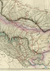
, but although the Maharajah of Kashmir apparently sent a few soldiers to man the abandoned fort at Shahidulla at one point, by the time most sources placed Shahidulla and the upper Karakash River firmly within the territory of East Turkestan (see accompanying map). According to Francis Younghusband
Francis Younghusband
Lieutenant Colonel Sir Francis Edward Younghusband, KCSI, KCIE was a British Army officer, explorer, and spiritual writer...
, who explored the region in the late 1880s, there was only an abandoned fort and not one inhabited house at Shahidulla when he was there - it was just a convenient staging post and a convenient headquarters for the nomadic Kirghiz. The abandoned fort had apparently been built a few years earlier by the Kashmiris. There is evidence that the Chinese had mined jade in the region at least as early as the Later Han Dynasty and up until the quarries were abandoned during the Muslim Rebellion in 1863-4, just prior to Mr. Johnson's trip in 1865.
Thomas Douglas Forsyth
Thomas Douglas Forsyth
-Early life:Forsyth was born in Birkenhead on 7 October 1827. He was the tenth child of Thomas Forsyth, a Liverpool merchant. He was educated at Sherborne and Rugby, and under private tuition until he entered the East India Company's College at Haileybury, where he remained until December 1847.-In...
who was entrusted with the task of visiting the Court of Atalik Ghazi pursuant to the visit on 28, March 1870 of the envoy of Atalik Ghazi, Mirza Mohammad Shadi, stated that "it would be very unsafe to define the boundary of Kashmir in the direction of the Karakoram…. Between the Karakoram and the Karakash the high Plateau is perhaps rightly described as rather a no-mans land, but I should say with a tendency to become Kashmir property".
Two stages beyond Shahidulla, as the route headed for the Sanju Pass, Forsyth’s party crossed the Tughra Su and passed an outpost called Nazr Qurghan. "This is manned by soldiers from Yarkand". In the words of John Lall, "Here we have an early example of coexistence. The Kashmiri and Yarkandi outposts were only two stages apart on either side of the Karakash river..." to the northwest of the Hindutash
Hindutash
Hindutash, also known as Hindu-tagh Pass, is a historical mountain pass in the western Xinjiang Uyghur Autonomous Region of the People's Republic of China...
in the north eastern frontier region of Kashmir. This was the status quo
Status quo
Statu quo, a commonly used form of the original Latin "statu quo" – literally "the state in which" – is a Latin term meaning the current or existing state of affairs. To maintain the status quo is to keep the things the way they presently are...
that existed at the time of the mission to Kashgar in 1873-74 by Forsyth. "Elias himself recalled that, following his mission to Kashgar in 1873-74, Sir Douglas Forsyth 'recommended the Maharaja’s boundary to be drawn to the north of the Karakash valley as shown in the map accompanying the mission report'. Whether this was ever done is doubtful.
The Chinese completed the reconquest of Eastern Turkestan in 1878. Although the Maharajah of Kashmir apparently indicated a wish to reoccupy the fort at Shahidulla in 1885, he was prevented from doing so by the British and so the territory remained under effective Chinese control.
The present situation
Since the reconquest of the whole region by China in 1878, it has been considered part of Sinkiang (Xinjiang) Province. and has remained so ever since. Shahidulla (Xaidulla) is well to the north of any territories claimed by either India or Pakistan, while the Sanju and Kilian passes are further to the north of Shahidulla. A major Chinese road runs from KargilikKargilik
Kargilik, sometimes also spelt Karghilik, can refer to* Kargilik County in southern Xinjiang Uighur Autonomous Region, China.* Yecheng, a city in southern Xinjiang Uighur Autonomous Region, China....
(Yecheng) in the Tarim Basin
Tarim Basin
The Tarim Basin is a large endorheic basin occupying an area of about . It is located in the Xinjiang Uyghur Autonomous Region in China's far west. Its northern boundary is the Tian Shan mountain range and its southern is the Kunlun Mountains on the northern edge of the Tibetan Plateau. The...
, south through Shahidulla, and across the disputed Aksai Chin
Aksai Chin
Aksai Chin is one of the two main disputed border areas between China and India, and the other is South Tibet, which comprises most of India's Arunachal Pradesh. It is administered by China as part of Hotan County in the Hotan Prefecture of Xinjiang Autonomous Region, but is also claimed by India...
region now controlled by China, but still claimed by India, and into northeastern Tibet
Tibet
Tibet is a plateau region in Asia, north-east of the Himalayas. It is the traditional homeland of the Tibetan people as well as some other ethnic groups such as Monpas, Qiang, and Lhobas, and is now also inhabited by considerable numbers of Han and Hui people...
(now Xizang Province).