
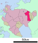
Kanzaki, Saga
Encyclopedia
is a city
located in Saga Prefecture
, Japan
. The city was created on March 20, 2006 by the merger of the towns of Kanzaki (old) and Chiyoda
, and the village of Sefuri
, all from Kanzaki District
. As a result of this merger there are no longer any village
level administration districts in Saga Prefecture.
in Fukuoka Prefecture
is formed by the Chikugo River.
in Kawasoe
, followed by Fukuoka Airport
.
Cities of Japan
||A is a local administrative unit in Japan. Cities are ranked on the same level as and , with the difference that they are not a component of...
located in Saga Prefecture
Saga Prefecture
is located in the northwest part of the island of Kyūshū, Japan. It touches both the Sea of Japan and the Ariake Sea. The western part of the prefecture is a region famous for producing ceramics and porcelain, particularly the towns of Karatsu, Imari, and Arita...
, Japan
Japan
Japan is an island nation in East Asia. Located in the Pacific Ocean, it lies to the east of the Sea of Japan, China, North Korea, South Korea and Russia, stretching from the Sea of Okhotsk in the north to the East China Sea and Taiwan in the south...
. The city was created on March 20, 2006 by the merger of the towns of Kanzaki (old) and Chiyoda
Chiyoda, Saga
was a town located in the Kanzaki District of Saga Prefecture, on the island of Kyūshū, Japan.As of 2003, the town had an estimated population of 11,924 and a population density of 481.39 persons per km²...
, and the village of Sefuri
Sefuri, Saga
was a village located in Kanzaki District, Saga, Japan.As of 2003, the village had an estimated population of 1,941 and a population density of 31.86 persons per km². The total area was 60.93 km²....
, all from Kanzaki District
Kanzaki District, Saga
is a district located in Saga Prefecture, Japan.As of February 1, 2009 the district has an estimated population of 16,308 and a density of 371 persons per km²...
. As a result of this merger there are no longer any village
Villages of Japan
A is a local administrative unit in Japan.It is a local public body along with , , and . Geographically, a village's extent is contained within a prefecture....
level administration districts in Saga Prefecture.
Geography
The northern part of the city is located in the middle of the Sefuri Mountains. As one goes south the elevation lowers. The southern part consists of the north bank of the Chikugo River and the Saga Plains, and the Jōbaru River runs through the middle portion of the city. The southeast border with KurumeKurume, Fukuoka
is a city located in Fukuoka prefecture, Japan.The city has an estimated population of 303,277 and a population density of 1,319.51 persons per km²...
in Fukuoka Prefecture
Fukuoka Prefecture
is a prefecture of Japan located on Kyūshū Island. The capital is the city of Fukuoka.- History :Fukuoka Prefecture includes the former provinces of Chikugo, Chikuzen, and Buzen....
is formed by the Chikugo River.
- Mountains: Mount SefuriMount Sefuriis a peak of the Sefuri Mountains, which are located on the border of Fukuoka, Fukuoka Prefecture, and Kanzaki, Saga Prefecture, Japan.-Outline:This mountain is the tallest peak of the Sefuri Mountain range between Fukuoka Prefecture and Saga Prefecture. Before the Meiji Restoration, this mountain...
(1055 m), Mt. Doki (Mt. Hatten, 430 m) - Rivers: Chikugo River, Jōbaru River, Tade River, Sanbonmatsu River
Adjoining municipalities
- Saga PrefectureSaga Prefectureis located in the northwest part of the island of Kyūshū, Japan. It touches both the Sea of Japan and the Ariake Sea. The western part of the prefecture is a region famous for producing ceramics and porcelain, particularly the towns of Karatsu, Imari, and Arita...
- MiyakiMiyaki, Sagais a town in Miyaki District, Saga Prefecture, Japan. It is the first town in Saga to have its name spelled in hiragana rather than kanji. It is named after the district it is located in.-Geography:...
- SagaSaga, Sagais the capital of Saga Prefecture, located on the island of Kyūshū, Japan.Saga was the capital of Saga Domain in the Edo period, and largest city of former Hizen Province....
- YoshinogariYoshinogari, Sagais a town located in Kanzaki District, Saga Prefecture, Japan. It is the result of a merger between the town of Mitagawa, and the village of Higashisefuri, both from Kanzaki District, on March 1, 2006.-Geography:...
- Miyaki
- Fukuoka PrefectureFukuoka Prefectureis a prefecture of Japan located on Kyūshū Island. The capital is the city of Fukuoka.- History :Fukuoka Prefecture includes the former provinces of Chikugo, Chikuzen, and Buzen....
- KurumeKurume, Fukuokais a city located in Fukuoka prefecture, Japan.The city has an estimated population of 303,277 and a population density of 1,319.51 persons per km²...
- ŌkawaOkawa, Fukuokais a city located in Fukuoka, Japan.As of October 1, 2007, the city has an estimated population of 38,374 and the density of 1,140 persons per km². The total area is 33.61 km².The city was founded on April 1, 1954. The name means 'big river'.-Geography:...
- Sawara Ward, Fukuoka CitySawara-ku, Fukuokais one of the seven wards of Fukuoka, Fukuoka Prefecture, Japan.-Data:*Population: 211,851 people *Area: 95.88 square kilometers -Profile:...
- Kurume
History
- April 1, 1889 — The modern municipal systemMunicipalities of JapanJapan has three levels of government: national, prefectural, and municipal. The nation is divided into 47 prefectures. Each prefecture consists of numerous municipalities. There are four types of municipalities in Japan: cities, towns, villages and special wards...
is established. The current city region consists of eight villagesVillages of JapanA is a local administrative unit in Japan.It is a local public body along with , , and . Geographically, a village's extent is contained within a prefecture....
: Chitose, Hasuike, Kanzaki, Niiyama, Saigō, Sakaino, Sefuri, Shirota. - 1893 — The village of Kanzaki becomes a town.
- November 3, 1935 — The village of Hasuike becomes a town.
- March 31, 1955 — The villages of Saigō and Niiyama merge into Kanzaki.
- April 1, 1955 — The villages of Chitose, Sakaino, Shirota, and part of the town of Hasuike merge to form the village of Chiyoda.
- April 1, 1965 — Chiyoda becomes a town.
- March 20, 2006 — The towns of Kanzaki and Chiyoda along with the village of Sefuri merge to form the city of Kanzaki.
Prefectural high schools
- Kanzaki High School (佐賀県立神埼高等学校)
- Kanzaki Seimei High School (佐賀県立神埼清明高等学校)
Municipal junior high schools
- Kanzaki Junior High School
- Chiyoda Junior High School
- Sefuri Junior High School
Municipal elementary schools
- Kanzaki Elementary School
- Saigō Elementary School
- Niiyama Elementary School
- Chiyoda Tōbu Elementary School
- Chiyoda Chūbu Elementary School
- Chiyoda Seibu Elementary School
- Sefuri Elementary School
Air
The nearest airport is Saga AirportSaga Airport
is an airport in the Kawasoe area of Saga, Saga Prefecture, Japan.-Airlines and destinations:-External links:*...
in Kawasoe
Kawasoe, Saga
was a town located in Saga District, Saga, Japan.On October 1, 2007 Kawasoe, along with the towns of Higashiyoka and Kubota, all from Saga District, was merged into the expanded city of Saga....
, followed by Fukuoka Airport
Fukuoka Airport
, formerly known as Itazuke Air Base, is an international and domestic airport located east of Hakata Station in Fukuoka, Japan. It is officially designated a second class airport. It is operating at full capacity, and cannot be further expanded. Flights stop at 10 p.m...
.
Road
- ExpresswaysExpressways of JapanThe expressways of Japan make up a large network of freeway-standard toll roads.- History :Following World War II, Japan's economic revival led to a massive increase in personal automobile use...
:- Nagasaki ExpresswayNagasaki Expressway' is one of the Expressways of Japan from Tosu to Nagasaki. It runs through the prefecture of Saga, and the southern half of the Nagasaki prefecture...
: The closest interchangeInterchange (road)In the field of road transport, an interchange is a road junction that typically uses grade separation, and one or more ramps, to permit traffic on at least one highway to pass through the junction without directly crossing any other traffic stream. It differs from a standard intersection, at which...
is the Higashi-Sefuri Interchange in Yoshinogari, SagaYoshinogari, Sagais a town located in Kanzaki District, Saga Prefecture, Japan. It is the result of a merger between the town of Mitagawa, and the village of Higashisefuri, both from Kanzaki District, on March 1, 2006.-Geography:...
.
- Nagasaki Expressway
- National highwaysNational highways of JapanJapan has a nationwide system of distinct from the expressways. The Ministry of Land, Infrastructure and Transport and other government agencies administer the national highways. Beginning in 1952, Japan classified these as Class 1 or Class 2. Class 1 highways had one- or two-digit numbers, while...
:- Route 34
- Route 264Route 264 (Japan)National Route 264 is a national highway of Japan connecting Saga, Saga and Kurume, Fukuoka in Japan, with a total length of 27.4 km ....
- Route 385Route 385 (Japan)National Route 385 is a national highway of Japan connecting Yanagawa, Fukuoka and Hakata-ku, Fukuoka in Japan, with a total length of 68.1 km ....
Notable places and festivals
- Kunen Hermitage
- Niiyama Shrine
- Kushida-gū
- Niiyama Park
- Hōshu-dera
- Yoshinogari Historical ParkYoshinogari siteYoshinogari is the name of a large and complex Yayoi archaeological site in Yoshinogari and Kanzaki in Saga Prefecture, Kyūshū, Japan. According to the Yayoi chronology established by pottery seriations in the 20th century, Yoshinogari dates to between the 3rd century BC and the 3rd century AD...
- Naotori Castle ruins
- Home of Kojin Shimomura
- Jirōnomori Park
- Holiday Chiyoda (堀デーちよだ)