Yoshinogari, Saga
Encyclopedia
is a town
located in Kanzaki District
, Saga Prefecture
, Japan
. It is the result of a merger
between the town of Mitagawa
, and the village of Higashisefuri
, both from Kanzaki District
, on March 1, 2006.
. It is about 10 kilometres (6.2 mi) north of Saga City
and about 30 kilometres (18.6 mi) south of Fukuoka
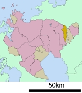
. Yoshinogari is very narrow north to south. The southern part contains the northern end of the Chikushi Plains (part of the Saga Plains), and north of the Nagasaki Expressway
is the southern end of the Sefuri Mountains
.
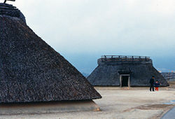
 In 1986, the remains of a Yayoi period
moat-encircled village were discovered on Yoshinogari Hill at the site of a planned factory housing complex. The area was named the Yoshinogari site and the town name originates from here.
Towns of Japan
A town is a local administrative unit in Japan. It is a local public body along with prefecture , city , and village...
located in Kanzaki District
Kanzaki District, Saga
is a district located in Saga Prefecture, Japan.As of February 1, 2009 the district has an estimated population of 16,308 and a density of 371 persons per km²...
, Saga Prefecture
Saga Prefecture
is located in the northwest part of the island of Kyūshū, Japan. It touches both the Sea of Japan and the Ariake Sea. The western part of the prefecture is a region famous for producing ceramics and porcelain, particularly the towns of Karatsu, Imari, and Arita...
, Japan
Japan
Japan is an island nation in East Asia. Located in the Pacific Ocean, it lies to the east of the Sea of Japan, China, North Korea, South Korea and Russia, stretching from the Sea of Okhotsk in the north to the East China Sea and Taiwan in the south...
. It is the result of a merger
Merger and dissolution of municipalities of Japan
Municipal mergers and dissolutions carried out in Japan can take place within one municipality or between multiple municipalities and are required to be based upon consensus.- Merger policy:...
between the town of Mitagawa
Mitagawa, Saga
was a town located in Kanzaki District, Saga, Japan.As of 2003, the town had an estimated population of 9,492 and a density of 874.84 persons per km²...
, and the village of Higashisefuri
Higashisefuri, Saga
was a village located in Kanzaki District, Saga, Japan.As of 2003, the village had an estimated population of 6,507 and a population density of 196.65 persons per km². The total area was 33.09 km²....
, both from Kanzaki District
Kanzaki District, Saga
is a district located in Saga Prefecture, Japan.As of February 1, 2009 the district has an estimated population of 16,308 and a density of 371 persons per km²...
, on March 1, 2006.
Geography
Yoshinogari is located in the northern part of Saga PrefectureSaga Prefecture
is located in the northwest part of the island of Kyūshū, Japan. It touches both the Sea of Japan and the Ariake Sea. The western part of the prefecture is a region famous for producing ceramics and porcelain, particularly the towns of Karatsu, Imari, and Arita...
. It is about 10 kilometres (6.2 mi) north of Saga City
Saga, Saga
is the capital of Saga Prefecture, located on the island of Kyūshū, Japan.Saga was the capital of Saga Domain in the Edo period, and largest city of former Hizen Province....
and about 30 kilometres (18.6 mi) south of Fukuoka
Fukuoka, Fukuoka
is the capital city of Fukuoka Prefecture and is situated on the northern shore of the island of Kyushu in Japan.Voted number 14 in a 2010 poll of the World's Most Livable Cities, Fukuoka is praised for its green spaces in a metropolitan setting. It is the most populous city in Kyushu, followed by...
. Yoshinogari is very narrow north to south. The southern part contains the northern end of the Chikushi Plains (part of the Saga Plains), and north of the Nagasaki Expressway
Nagasaki Expressway
' is one of the Expressways of Japan from Tosu to Nagasaki. It runs through the prefecture of Saga, and the southern half of the Nagasaki prefecture...
is the southern end of the Sefuri Mountains
Mount Sefuri
is a peak of the Sefuri Mountains, which are located on the border of Fukuoka, Fukuoka Prefecture, and Kanzaki, Saga Prefecture, Japan.-Outline:This mountain is the tallest peak of the Sefuri Mountain range between Fukuoka Prefecture and Saga Prefecture. Before the Meiji Restoration, this mountain...
.
Adjoining Municipalities
- Saga PrefectureSaga Prefectureis located in the northwest part of the island of Kyūshū, Japan. It touches both the Sea of Japan and the Ariake Sea. The western part of the prefecture is a region famous for producing ceramics and porcelain, particularly the towns of Karatsu, Imari, and Arita...
- KamimineKamimine, Sagais a town located in Miyaki District, Saga, Japan.-Geography:Kamimine is located in the eastern part of Saga Prefecture about east of central Saga, the capital city. It is also about west of Kurume, a major city in Fukuoka Prefecture. There is a lot of flat land in Kamimine as the town area...
- KanzakiKanzaki, Sagais a city located in Saga Prefecture, Japan. The city was created on March 20, 2006 by the merger of the towns of Kanzaki and Chiyoda, and the village of Sefuri, all from Kanzaki District...
- MiyakiMiyaki, Sagais a town in Miyaki District, Saga Prefecture, Japan. It is the first town in Saga to have its name spelled in hiragana rather than kanji. It is named after the district it is located in.-Geography:...
- Kamimine
- Fukuoka PrefectureFukuoka Prefectureis a prefecture of Japan located on Kyūshū Island. The capital is the city of Fukuoka.- History :Fukuoka Prefecture includes the former provinces of Chikugo, Chikuzen, and Buzen....
- Fukuoka City, Sawara WardSawara-ku, Fukuokais one of the seven wards of Fukuoka, Fukuoka Prefecture, Japan.-Data:*Population: 211,851 people *Area: 95.88 square kilometers -Profile:...
- NakagawaNakagawa, Fukuokais a town located in Chikushi District, Fukuoka, Japan.As of 2003, the town has an estimated population of 46,540 and a density of 620.62 persons per km². The total area is 74.99 km².-External links:*...
- Fukuoka City, Sawara Ward
History

Yayoi period
The is an Iron Age era in the history of Japan traditionally dated 300 BC to 300 AD. It is named after the neighbourhood of Tokyo where archaeologists first uncovered artifacts and features from that era. Distinguishing characteristics of the Yayoi period include the appearance of new...
moat-encircled village were discovered on Yoshinogari Hill at the site of a planned factory housing complex. The area was named the Yoshinogari site and the town name originates from here.
- April 1, 1889 - The modern system of municipalities is established, and the town area consists of Mitagawa Village and Higashi-Sefuri Village.
- April 1, 1965 - Mitagawa Village becomes Mitagawa Town.
- March 1, 2006 - Mitagawa Town and Higashi-Sefuri village merge to form Yoshinogari Town.
Road
- ExpresswaysExpressways of JapanThe expressways of Japan make up a large network of freeway-standard toll roads.- History :Following World War II, Japan's economic revival led to a massive increase in personal automobile use...
: Nagasaki ExpresswayNagasaki Expressway' is one of the Expressways of Japan from Tosu to Nagasaki. It runs through the prefecture of Saga, and the southern half of the Nagasaki prefecture...
(Higashi-Sefuri Interchange) - National HighwaysNational highways of JapanJapan has a nationwide system of distinct from the expressways. The Ministry of Land, Infrastructure and Transport and other government agencies administer the national highways. Beginning in 1952, Japan classified these as Class 1 or Class 2. Class 1 highways had one- or two-digit numbers, while...
: Route 34 and Route 385Route 385 (Japan)National Route 385 is a national highway of Japan connecting Yanagawa, Fukuoka and Hakata-ku, Fukuoka in Japan, with a total length of 68.1 km ....
. - Prefectural Roads: Saga Prefectural Route 31, and Route 46

