
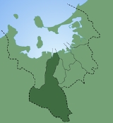
Sawara-ku, Fukuoka
Encyclopedia

Wards of Japan
A is a subdivision of one of the cities of Japan that is large enough to have been designated by government ordinance. Wards are used to subdivide each city designated by government ordinance...
of Fukuoka
Fukuoka
Fukuoka most often refers to the capital city of Fukuoka Prefecture.It can also refer to:-Locations:* Fukuoka, Gifu, a town in Gifu Prefecture, Japan* Fukuoka, Toyama, a town in Toyama Prefecture, Japan...
, Fukuoka Prefecture
Fukuoka Prefecture
is a prefecture of Japan located on Kyūshū Island. The capital is the city of Fukuoka.- History :Fukuoka Prefecture includes the former provinces of Chikugo, Chikuzen, and Buzen....
, Japan
Japan
Japan is an island nation in East Asia. Located in the Pacific Ocean, it lies to the east of the Sea of Japan, China, North Korea, South Korea and Russia, stretching from the Sea of Okhotsk in the north to the East China Sea and Taiwan in the south...
.
Data
- Population: 211,851 people (as of March 1, 2009)
- Area: 95.88 square kilometers (the largest)
Profile
On April 1, 1889, Fukuoka-shi was founded. The northeastern part of the former Sawara-gun (早良郡, Sawara DistrictSawara District, Fukuoka
Sawara was a district located in Fukuoka Prefecture, Japan.The district was dissolved on March 1, 1975, when the town of Sawara merged into the expanded city of Fukuoka....
) was merged into Fukuoka-shi.
On April 1, 1972, Fukuoka-shi was designated as a government ordinance city. Fukuoka-shi was subdivided into five wards: Hakata-ku
Hakata-ku, Fukuoka
is one of the seven wards of Fukuoka City, Fukuoka Prefecture, Japan. It is best known as the location of Fukuoka's main train station, Hakata Station.-Geography:...
, Chūō-ku
Chuo-ku, Fukuoka
is one of the seven wards of Fukuoka city in Japan. The ward is located in the center of the city.It includes Tenjin and Daimyō which are among the largest downtown areas in Kyūshū, Nagahama, which is known for its fish market, and Ōhori Park.-Main facilities:...
, Higashi-ku
Higashi-ku, Fukuoka
is one of the seven wards of Fukuoka City, Japan. As of 2004, it has a population of 275,652 people and an area of 66.68 sq. km. Its name literally means "east ward".Kashii is in this ward. It is south of neighbouring Shingū, Fukuoka....
, Minami-ku
Minami-ku, Fukuoka
is one of the seven wards of Fukuoka City, Japan. As of 2004, it had a population of 247,913 people and an area of 30.98 km2. Its name literally means "south ward." It is bordered by the central, Hakata, Jonan, and Sawara wards of Fukuoka city, and also by the cities of Nakagawa and Kasuga....
and the former Nishi-ku
Nishi-ku, Fukuoka
is one of the seven wards of Fukuoka City, Japan. Meaning literally "west ward," it is bordered to the east by Sawara-ku, and to the west by Maebaru and Shima. As of 2003, it has a population of 173,813 people and an area of 83.81 km2...
. The area now called Sawara-ku was the central part of the former Nishi-ku.
On March 1, 1975, the town of Sawara
Sawara, Fukuoka
was a town located in Sawara District, Fukuoka Prefecture. On March 1, 1975, the town merged with the expanded city of Fukuoka.-History:*On August 1, 1956, the villages of Irube, Wakiyama and Uchino were merged to form the town of Sawara....
was merged into Fukuoka-shi.
On May 10, 1982, the former Nishi-ku was subdivided into three wards: Sawara-ku, Jōnan-ku
Jonan-ku, Fukuoka
is one of the seven wards of Fukuoka City, Japan. As of November 1, 2004, it had a population of 128,057 people, making up 9.2% of Fukuoka City, with an area of 16.02 km2. At the time of Fukuoka City's official designation as a City in 1972, the area now known as Jōnan-ku was part of the...
and Nishi-ku. The area now called Sawara-ku was named after that it had been the central part of the former Sawara-gun.
Places
- Momochihama (百道浜): Fukuoka TowerFukuoka Toweris a 234 metre tall tower located in the Momochihama area of Fukuoka, Japan. It is the tallest seaside tower in Japan. Fukuoka Tower was finished in 1989, taking a total of 14 months to build at a cost of ¥6,000,000,000. It was designed by Nikken Sekkei...
, Fukuoka City Museum, Fukuoka City Library - Nishijin (西新): Nishijin Praliva
- Fujisaki (藤崎): Sawara Ward Office, Fukuoka Prefecture Sawara Police Station, Fujisaki Bus Terminal
- Hara (原): Hara Saty
- Noke (野芥)
- Higashiirube (東入部): Sawara Ward Irube Branch Office
Schools
- Momochihama: Seinan Gakuin Junior and Senior High School
- Nishijin: Seinan Gakuin UniversitySeinan Gakuin Universityis a Christian university in Fukuoka, Japan. Seinan Gakuin, founded in 1916 by Rev. C. K. Dozier, a Southern Baptist missionary from the United States, includes , , a as well as the University . The chancellor of Seinan Gakuin is Yoshiki Terazono, and Gary W. Barkley, a former Baptist missionary,...
, Fukuoka Prefecture Shūyūkan High School - Momochi (百道): Fukuoka International SchoolInternational schoolAn International school is loosely defined as a school that promotes international education, in an international environment, either by adopting an international curriculum such as that of the International Baccalaureate or Cambridge International Examinations, or by following a national...
- Arita (有田): Fukuoka Prefecture Kōrinkan High School (the former Nishifukuoka High School)
- Tamura (田村): Fukuoka Dental College
Stations
- Fukuoka City SubwayFukuoka City SubwayThe serves Fukuoka, Japan. It consists of three subway lines, the Kūkō, or Airport Line, the Hakozaki Line and the Nanakuma Line).The lines are operated by the . Unlike most other public operators in Japan, the company only operates subways without any bus lines....
Kūkō Line: Nishijin, Fujisaki, Muromi (室見) - Fukuoka City Subway Nanakuma Line: Noke, Kamo (賀茂), Jirōmaru (次郎丸)
Roads
Sawara-kaidō Avenue (早良街道, Sawara Road) is a historical road consisting of Prefectural Route 558 (Hara-dōri Avenue, 原通り) and the southern part of National Route 263. Sawara-gaidō Street (早良街道) is an official road consisting of Municipal Route Nishijin-Arae and the northern part of National Route 263.- National Route 202 (Prefectural Route 559)
- National Route 202 Bypass
- National Route 263
- Prefectural Route 49
- Prefectural Route 56
- Prefectural Route 136
- Prefectural Route 558
- Municipal Route Chiyo-Imajuku
- Municipal Route Nishijin-Arae