

Kahayan River
Encyclopedia
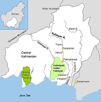
Central Kalimantan
Central Kalimantan is a province of Indonesia, one of four in Kalimantan - the Indonesian part of the island of Borneo. Its provincial capital is Palangka Raya.The province has a population of just over 2.2 million at the 2010 Census...
, a province of Indonesia
Provinces of Indonesia
The province is the highest tier of local government subnational entity in Indonesia. Each province has its own local government, headed by a governor, and has its own legislative body...
in Kalimantan
Kalimantan
In English, the term Kalimantan refers to the Indonesian portion of the island of Borneo, while in Indonesian, the term "Kalimantan" refers to the whole island of Borneo....
- the Indonesia
Indonesia
Indonesia , officially the Republic of Indonesia , is a country in Southeast Asia and Oceania. Indonesia is an archipelago comprising approximately 13,000 islands. It has 33 provinces with over 238 million people, and is the world's fourth most populous country. Indonesia is a republic, with an...
n part of the island of Borneo
Borneo
Borneo is the third largest island in the world and is located north of Java Island, Indonesia, at the geographic centre of Maritime Southeast Asia....
. The provincial capital Palangkaraya
Palangkaraya
Palangka Raya is the capital city of the Indonesian province Central Kalimantan, situated between the Kayahan and the Sabangau rivers. The population of the municipality is 170,761. The closest airport serving the city is Tjilik Riwut.- History :...
lies on the river. The main inhabitants are Dyaks, who practice slash-and-burn
Slash and burn
Slash-and-burn is an agricultural technique which involves cutting and burning of forests or woodlands to create fields. It is subsistence agriculture that typically uses little technology or other tools. It is typically part of shifting cultivation agriculture, and of transhumance livestock...
rice cultivation and pan for gold on the upper reaches. The lower Kayahan flows through a rich and unusual environment of peat swamp forests
Borneo peat swamp forests
The Borneo peat swamp forests ecoregion, within the Tropical and subtropical moist broadleaf forests Biome, are on the island of Borneo, which is divided between Brunei, Indonesia and Malaysia.-Location and description:...
, which has been severely degraded by an unsuccessful program to convert a large part of the area into rice paddies, compounded by legal and illegal forestry.
Geography

Rattan
Rattan is the name for the roughly 600 species of palms in the tribe Calameae, native to tropical regions of Africa, Asia and Australasia.- Structure :...
, resin
Resin
Resin in the most specific use of the term is a hydrocarbon secretion of many plants, particularly coniferous trees. Resins are valued for their chemical properties and associated uses, such as the production of varnishes, adhesives, and food glazing agents; as an important source of raw materials...
and high-quality woods. The climate is hot and humid, typically around 30o most of the year. Annual rainfall is between 2800 and 3400 mm.
The Kahayan River originates in the northern mountains, then meander
Meander
A meander in general is a bend in a sinuous watercourse. A meander is formed when the moving water in a stream erodes the outer banks and widens its valley. A stream of any volume may assume a meandering course, alternately eroding sediments from the outside of a bend and depositing them on the...
s for 600 km southward through the plains to the Java Sea
Java Sea
The Java Sea is a large shallow sea on the Sunda Shelf. It was formed as sea levels rose at the end of the last ice age. The Java Sea lies between the Indonesian islands of Borneo to the north, Java to the south; Sumatra to the west, and Sulawesi to the east...
. Tidal effects are felt 50 km - 80 km inland from the sea. A recent study found 28 species of fish throughout the river, 44 species in the Danau Sabuah lake and 12 species in the traditional fish ponds. The riparian wetlands
Riparian zone
A riparian zone or riparian area is the interface between land and a river or stream. Riparian is also the proper nomenclature for one of the fifteen terrestrial biomes of the earth. Plant habitats and communities along the river margins and banks are called riparian vegetation, characterized by...
were the main spawning areas. Fishermen are reporting declining yields due to problems with water quality.
People
Kaharingan
Kaharingan, is a folk religion professed by many Dayaks in Kalimantan, Indonesia.The word Kaharingan means life, and this belief system includes a concept of a supreme deity—although this may be the result of the need to conform to the idea of "One Supreme God" , which is the first principle of the...
religion. They speak languages of the Barito family, related to the Malagasy language
Malagasy language
Malagasy is the national language of Madagascar, a member of the Austronesian family of languages. Most people in Madagascar speak it as a first language as do some people of Malagasy descent elsewhere.-History:...
spoken in Madagascar
Madagascar
The Republic of Madagascar is an island country located in the Indian Ocean off the southeastern coast of Africa...
. The Kaharingan religion combines anchestor worship, animism and dynamism. It is now considered a form of Hinduism
Hinduism
Hinduism is the predominant and indigenous religious tradition of the Indian Subcontinent. Hinduism is known to its followers as , amongst many other expressions...
.
The main Dayak tribes are the Ngaju
Ngaju people
Ngaju are indigenous people of Borneo from the Dayak group. They speak Ngaju language.-External links:*...
, Ot Danum and Ma'anyan
Ma'anyan people
Ma'anyan or Maanyak are a people indigenous to Borneo from the Dayak group. They speak Ma'anyan language.-External links:...
. The Ot Danum remain in the upstream regions of the Kahayan, Barito, Kapuas and Rungan rivers and preserve a traditional way of life. Many still live in longhouses and subsist through hunting, fishing and basic agriculture. Village elders practice traditional medicine and mark their status with intricate body tattoos and heavy ear adornments. The Ngaju have moved downstream, and to some extent assimilated with the mixed population of the towns further down the river, which includes Javanese, Maduranese, Batak
Batak (Indonesia)
Batak is a collective term used to identify a number of ethnic groups predominantly found in North Sumatra, Indonesia. The term is used to include the Toba, Karo, Pakpak, Simalungun, Angkola and Mandailing, each of which are distinct but related groups with distinct, albeit related, languages and...
, Toraja
Toraja
The Toraja are an ethnic group indigenous to a mountainous region of South Sulawesi, Indonesia. Their population is approximately 650,000, of which 450,000 still live in the regency of Tana Toraja . Most of the population is Christian, and others are Muslim or have local animist beliefs known as aluk...
, Ambonese
Ambonese
The Ambonese, also known as South Moluccans, are an Indonesian ethnic group of mixed Malay-Papuan origin. They are mostly Christians or Muslims. Ambonese are from Ambon Island in Maluku, an island group east of Sulawesi and north of Timor in Indonesia. The predominant language of the island is...
, Bugis
Bugis
The Bugis are the most numerous of the three major linguistic and ethnic groups of South Sulawesi, the southwestern province of Sulawesi, Indonesia's third largest island. Although many Bugis live in the large port cities of Makassar and Parepare, the majority are farmers who grow wet rice on the...
, Palembang
Palembang
Palembang is the capital city of the South Sumatra province in Indonesia. Palembang is one of the oldest cities in Indonesia, and has a history of being a capital of a maritime empire. Located on the Musi River banks on the east coast of southern Sumatra island, it has an area of 400.61 square...
, Minang, Banjarese, Makassar
Makassar
Makassar, is the provincial capital of South Sulawesi, Indonesia, and the largest city on Sulawesi Island. From 1971 to 1999, the city was named Ujung Pandang, after a precolonial fort in the city, and the two names are often used interchangeably...
, Papuan, Balinese
Balinese people
The Balinese population of 3.0 million live mostly on the island of Bali, making up 89% of the island's population. There are also significant populations on the island of Lombok, and in the eastern-most regions of Java The Balinese population of 3.0 million (1.5% of Indonesia's population) live...
, Acehnese
Acehnese people
The Acehnese are a people in Aceh, Indonesia. Their homeland is located in the northern-most tip of the island of Sumatra and had a history of political struggle against the Dutch...
and Chinese
Chinese people
The term Chinese people may refer to any of the following:*People with Han Chinese ethnicity ....
.
Peat Swamp Forest and the Mega Rice Project
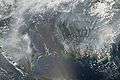
In 1996 the government initiated the Mega Rice Project
Mega Rice Project (Kalimantan)
The Mega Rice Project was initiated in 1996 in the southern sections of Kalimantan, the Indonesian section of Borneo. The goal was to turn one million hectares of unproductive and sparsely populated peat swamp forest into rice paddies in an effort to allieviate Indonesia's growing food shortage....
(MRP), which aimed to convert one million hectares of peat swamp forest to rice paddies
Paddy field
A paddy field is a flooded parcel of arable land used for growing rice and other semiaquatic crops. Paddy fields are a typical feature of rice farming in east, south and southeast Asia. Paddies can be built into steep hillsides as terraces and adjacent to depressed or steeply sloped features such...
. Between 1996 and 1998, more than 4,000 km of drainage and irrigation channels were dug, and deforestation
Deforestation in Borneo
Borneo, the third largest island in the world, divided between Indonesia, Malaysia and Brunei, was once covered with dense rainforests, but along with its tropical lowland and highland forests, there has been extensive deforestation in the past sixty years. In the 1980s and 1990s the forests of...
started in part through legal and illegal forestry and in part through burning. It turned out that the channels drained the peat forests rather than irrigating them. Where the forests had often flooded up to 2m deep in the rainy season, now their surface is dry at all times of the year. The government has therefore abandoned the MRP, but the drying peat is vulnerable to fires which continue to break out on a massive scale.
Peat forest destruction is causing sulphuric acid pollution of the rivers. In the rainy seasons, the canals are discharging acidic water with a high ratio of pyritic sulphate
Pyrite
The mineral pyrite, or iron pyrite, is an iron sulfide with the formula FeS2. This mineral's metallic luster and pale-to-normal, brass-yellow hue have earned it the nickname fool's gold because of its resemblance to gold...
into the Kahayan river up to 150 km upstream from the river mouth. This may be a factor contributing to lower fish catches.
Mining
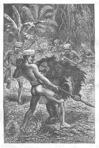
People have panned for gold in the Kahayan river for centuries. Following test drilling, a consortium of Canadian and Indonesian companies announced in 1997 that in-situ gold resources were at least 3.4 million ounces. In 2002 a Canadian company with a background in community development programs proposed to develop artisanal mining in the headwaters of the Barito and Kahayan Rivers in Kalimantan, providing income for some 13,000 Dayak people at project maturity. A large number of informal prospectors are undertaking alluvial operations within the river system, and mining hard rock gold veins. Even those doing hard rock mining transport the ore to the rivers for processing. More than 2,000 illegal miners may converge on a site when there is a reported gold find. In Indonesia as a whole, nearly 180 tonnes of mercury are released to the environment annually.Kelompok Hutan Kahayan or Sabangau Forest
.jpg)
Storm's Stork
The Storm's Stork, Ciconia stormi is a large, approximately long, stork with black and white plumages, red bill, orange bare facial skin, red legs and yellow orbital skin. Both sexes are similar. The young has duller plumage and bare skin....
(Ciconia stormi) and Lesser Adjutant
Lesser Adjutant
The Lesser Adjutant, Leptoptilos javanicus, is a large wading bird in the stork family Ciconiidae. It is a widespread species which is resident breeder in southern Asia from India east to southern China and Java....
(Leptoptilus javanicus). The Sabangau Forest is centered on the blackwater
Blackwater river
A blackwater river is a river with a deep, slow-moving channel that flows through forested swamps and wetlands. As vegetation decays in the water, tannins are leached out, resulting in transparent, acidic water that is darkly stained, resembling tea or coffee. Most major blackwater rivers are in...
Sabangau River. There is no longer any continuous forest cover where Orang Utans may cross this river. The forest has been badly damaged by legal and illegal forestry, but the western part is now protected as either National Park or National Laboratory Research Area. With a relatively small human population, there is some hope that this area of the forest may recover. The more badly damaged eastern part, between the Sabangau and the Kayahan, is still officially designated for agriculture, although no further efforts are being made to make it suitable for this purpose.