
Juneau mining district
Encyclopedia
The Juneau mining district is a gold mining area in the U.S. state of Alaska
.
In 1880 a local inhabitant, Chief Kowee, revealed to prospectors Joe Juneau
and Richard Harris
the presence of gold
in what is now named Gold Creek in Silver Bow Basin. The city of Juneau
was founded there that year.
The strike sparked the Juneau gold rush
which resulted in the development of many placer and lode mines including the largest, in their time, gold mines in the world: the Treadwell complex of lode mines on Douglas Island
(across a narrow sea channel from Juneau) and the AJ lode mine, in Juneau itself. The steep, wet, timber-covered, seaside mountain setting provided water power, transportation, and lumber such that, "extraordinarily low costs of operation make available low grade ore that under conditions only slightly different would be valueless."
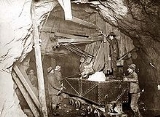
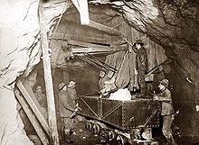
The first claims of what was to become the Treadwell complex were staked in 1881. Mining the Treadwell site began by sluicing residual placers over the lode deposits. Underground mining began with a five-stamp mill operating in 1883. In the mid-1910s, with 960 stamps grinding ore and tunnels reaching as far as 2400 feet (731.5 m) below the surface and extending under the sea, Treadwell was one of the most technologically advanced mines of its day. Up to 2000 people worked at the mine before a collapse allowed the rising tide to flood the tunnels in 1917. All operations at the Treadwell ceased by 1922.
As the Treadwell mines declined and closed, the AJ (Alaska Juneau) mine rose in prominence. After years of losses and labor problems, the mine became profitable in the mid-1920s: with 600 workers it was setting production records. Through the decade, it was the main economic engine of Juneau. In the 1930s, with 1000 workers, it was an important factor in softening the impact upon Juneau of the Great Depression.
Economic pressures of WWII lead to the closure of the AJ in 1944; this was the end of the dominance of mining in the Juneau economy.
Although those two mines are long-since closed, as late as 2010 one of the hydropower plants built to power the AJ was still in use. Fires and time have destroyed most traces of the Treadwell complex; the AJ mine buildings were burned by vandals and little can be seen by visitors these days because of the growth of alders.
The Juneau mining district; comprising the area between the Canadian border, Lynn Canal
, Admiralty Island
, and Frederick Sound
, has produced over 7 million ounces of lode gold and 80,000 ounces of placer gold.
 French Canadian
prospector Pierre Erussard, known as “French Pete,” found gold on Douglas Island
, across Gastineau Channel
from Juneau
. A consortium led by John Treadwell, a carpenter from California
, purchased the claims and adjoining gold-bearing land. The resulting mine/mill complex produced more than 3 million troy ounces (93 tonnes) of gold before closing in 1922.
.
Development and ore production occurred at the Kensington mine site from 1897 through 1938. The adjacent, also underground, Jualin mine was discovered in 1895 and operated from 1896 to 1928. Together the mines produced 40,513 ounces of gold from 75,208 tons of ore.
Interest in the dormant mines was renewed during the 1980s and 1990s. The Kensington Project is now in the final stages of permitting. The proposed underground mine will produce approximately 2,000 tons of ore per day and 400 tons per day of development rock over an estimated 10 years. The project now encompasses both the Kensington and Jualin prospects. The proposed mine, access roads, and tailings disposal areas are located on federal land overseen by the U.S. Forest Service (USFS), State of Alaska tidelands, and on private patented property. The project will employ approximately 300 to 400 people during the 22 months required for construction of the facilities and 225 full time employees to operate the mine and processing facilities. The operation will use a froth flotation
process which involves crushing the ore then flooding the ore with water containing chemicals which combine with gold, float to the surface, and are skimmed off.
On June 22, the Supreme Court of the United States issued a 6-3 decision which ruled that the United States Army Corp of Engineers had properly issued a permit allowing mine slurry, crushed rock mixed with water, to be discharged as "fill" into Lower Slate Lake, a 23 acres (93,077.8 m²) lake with a maximum depth of 50 feet (15.2 m). The Environmental Protection Agency deferred to the decision of the Corp of Engineers with respect to the discharge of waste into the lake, issuing a permit for discharge of treated water from the lake. While waste is being discharged into the lake surface waters are routed around it. A dam will be built to impound water as the original lake is filled by waste, the area of the lake being enlarged to 50 acres (202,343 m²) over the life of the project. At the termination of the project the bottom of the lake will be coated with native material and the lake restocked. The alternative to use of the lake for waste disposal was building of tailing ponds which would have displaced wetlands. Enlargement of the lake will produce additional wetlands, at least according to the majority opinion in the Supreme Court case. Environmental groups maintain that this decision was made possible by an administrative rule change made by the Bush administration:
The rule could be overturned by pending legislation, The Clean Water Protection Act
, H.R. 1310, amending the Clean Air Act
sponsored by Representatives Frank Pallone
(D-NJ) and Dave Reichert
(R-WA) and 151 cosponsors. Also a new or amended rule could be adopted or the informal memo withdrawn. A related controversy, also involving mining, and affected by the same rule change, is the practice of Mountaintop removal mining which involves dumping overburden into stream beds in adjacent valleys.
Alaska
Alaska is the largest state in the United States by area. It is situated in the northwest extremity of the North American continent, with Canada to the east, the Arctic Ocean to the north, and the Pacific Ocean to the west and south, with Russia further west across the Bering Strait...
.
In 1880 a local inhabitant, Chief Kowee, revealed to prospectors Joe Juneau
Joe Juneau (prospector)
Joseph Juneau was a miner and prospector from Canada who was born in the Quebec town of Saint-Paul-l'Ermite to François Xavier Juneau dit Latulippe and Marguerite Thiffault Juneau. He is best known for co-founding, with Richard Harris, the city of Juneau, Alaska, United States...
and Richard Harris
Richard Harris (prospector)
Richard Tighe Harris was a Canadian miner and prospector.Richard Harris was born in Dummadonald, County Down, Ireland. However, attended Girard College, a private boarding school in Philadelphia, PA ....
the presence of gold
Gold
Gold is a chemical element with the symbol Au and an atomic number of 79. Gold is a dense, soft, shiny, malleable and ductile metal. Pure gold has a bright yellow color and luster traditionally considered attractive, which it maintains without oxidizing in air or water. Chemically, gold is a...
in what is now named Gold Creek in Silver Bow Basin. The city of Juneau
Juneau, Alaska
The City and Borough of Juneau is a unified municipality located on the Gastineau Channel in the panhandle of the U.S. state of Alaska. It has been the capital of Alaska since 1906, when the government of the then-District of Alaska was moved from Sitka as dictated by the U.S. Congress in 1900...
was founded there that year.
The strike sparked the Juneau gold rush
Gold rush
A gold rush is a period of feverish migration of workers to an area that has had a dramatic discovery of gold. Major gold rushes took place in the 19th century in Australia, Brazil, Canada, South Africa, and the United States, while smaller gold rushes took place elsewhere.In the 19th and early...
which resulted in the development of many placer and lode mines including the largest, in their time, gold mines in the world: the Treadwell complex of lode mines on Douglas Island
Douglas Island
Douglas Island is a tidal island in the U.S. state of Alaska, just west of downtown Juneau and east of Admiralty Island. It is separated from mainland Juneau by the Gastineau Channel. The Juneau-Douglas Bridge, connecting the island with Juneau, provides a two lane road to and from the island and...
(across a narrow sea channel from Juneau) and the AJ lode mine, in Juneau itself. The steep, wet, timber-covered, seaside mountain setting provided water power, transportation, and lumber such that, "extraordinarily low costs of operation make available low grade ore that under conditions only slightly different would be valueless."
The first claims of what was to become the Treadwell complex were staked in 1881. Mining the Treadwell site began by sluicing residual placers over the lode deposits. Underground mining began with a five-stamp mill operating in 1883. In the mid-1910s, with 960 stamps grinding ore and tunnels reaching as far as 2400 feet (731.5 m) below the surface and extending under the sea, Treadwell was one of the most technologically advanced mines of its day. Up to 2000 people worked at the mine before a collapse allowed the rising tide to flood the tunnels in 1917. All operations at the Treadwell ceased by 1922.
As the Treadwell mines declined and closed, the AJ (Alaska Juneau) mine rose in prominence. After years of losses and labor problems, the mine became profitable in the mid-1920s: with 600 workers it was setting production records. Through the decade, it was the main economic engine of Juneau. In the 1930s, with 1000 workers, it was an important factor in softening the impact upon Juneau of the Great Depression.
Economic pressures of WWII lead to the closure of the AJ in 1944; this was the end of the dominance of mining in the Juneau economy.
Although those two mines are long-since closed, as late as 2010 one of the hydropower plants built to power the AJ was still in use. Fires and time have destroyed most traces of the Treadwell complex; the AJ mine buildings were burned by vandals and little can be seen by visitors these days because of the growth of alders.
The Juneau mining district; comprising the area between the Canadian border, Lynn Canal
Lynn Canal
Lynn Canal is an inlet into the mainland of southeast Alaska.Lynn Canal runs about from the inlets of the Chilkat River south to Chatham Strait and Stephens Passage...
, Admiralty Island
Admiralty Island
Admiralty Island is an island in the Alexander Archipelago in Southeast Alaska, at . It is 145 km long and 56 km wide with an area of 4,264.1 km² , making it the seventh largest island in the United States and the 132nd largest island in the world. It is one of the...
, and Frederick Sound
Frederick Sound
Frederick Sound is a passage of water in the Alexander Archipelago in southeastern Alaska that separates Kupreanof Island to the south from Admiralty Island in the north....
, has produced over 7 million ounces of lode gold and 80,000 ounces of placer gold.
Treadwell mine
French Canadian
French Canadian or Francophone Canadian, , generally refers to the descendents of French colonists who arrived in New France in the 17th and 18th centuries...
prospector Pierre Erussard, known as “French Pete,” found gold on Douglas Island
Douglas Island
Douglas Island is a tidal island in the U.S. state of Alaska, just west of downtown Juneau and east of Admiralty Island. It is separated from mainland Juneau by the Gastineau Channel. The Juneau-Douglas Bridge, connecting the island with Juneau, provides a two lane road to and from the island and...
, across Gastineau Channel
Gastineau Channel
Gastineau Channel is a channel between the mainland of the U.S. state of Alaska and Douglas Island in the Alexander Archipelago of southeastern Alaska. It separates Juneau on the mainland side from Douglas , on Douglas Island. The first European to sight the channel was Joseph Whidbey early in...
from Juneau
Juneau, Alaska
The City and Borough of Juneau is a unified municipality located on the Gastineau Channel in the panhandle of the U.S. state of Alaska. It has been the capital of Alaska since 1906, when the government of the then-District of Alaska was moved from Sitka as dictated by the U.S. Congress in 1900...
. A consortium led by John Treadwell, a carpenter from California
California
California is a state located on the West Coast of the United States. It is by far the most populous U.S. state, and the third-largest by land area...
, purchased the claims and adjoining gold-bearing land. The resulting mine/mill complex produced more than 3 million troy ounces (93 tonnes) of gold before closing in 1922.
Kensington & Jualin mines (under development)
The underground Kensington hardrock mine is approximately 45 miles (72.4 km) north of Juneau. The mine site is within the City and Borough of Juneau and the Tongass National ForestTongass National Forest
The Tongass National Forest in southeastern Alaska is the largest national forest in the United States at 17 million acres . Most of its area is part of the temperate rain forest WWF ecoregion, itself part of the larger Pacific temperate rain forest WWF ecoregion, and is remote enough to be home...
.
Development and ore production occurred at the Kensington mine site from 1897 through 1938. The adjacent, also underground, Jualin mine was discovered in 1895 and operated from 1896 to 1928. Together the mines produced 40,513 ounces of gold from 75,208 tons of ore.
Interest in the dormant mines was renewed during the 1980s and 1990s. The Kensington Project is now in the final stages of permitting. The proposed underground mine will produce approximately 2,000 tons of ore per day and 400 tons per day of development rock over an estimated 10 years. The project now encompasses both the Kensington and Jualin prospects. The proposed mine, access roads, and tailings disposal areas are located on federal land overseen by the U.S. Forest Service (USFS), State of Alaska tidelands, and on private patented property. The project will employ approximately 300 to 400 people during the 22 months required for construction of the facilities and 225 full time employees to operate the mine and processing facilities. The operation will use a froth flotation
Froth flotation
Froth flotation is a process for selectively separating hydrophobic materials from hydrophilic. This is used in several processing industries...
process which involves crushing the ore then flooding the ore with water containing chemicals which combine with gold, float to the surface, and are skimmed off.
On June 22, the Supreme Court of the United States issued a 6-3 decision which ruled that the United States Army Corp of Engineers had properly issued a permit allowing mine slurry, crushed rock mixed with water, to be discharged as "fill" into Lower Slate Lake, a 23 acres (93,077.8 m²) lake with a maximum depth of 50 feet (15.2 m). The Environmental Protection Agency deferred to the decision of the Corp of Engineers with respect to the discharge of waste into the lake, issuing a permit for discharge of treated water from the lake. While waste is being discharged into the lake surface waters are routed around it. A dam will be built to impound water as the original lake is filled by waste, the area of the lake being enlarged to 50 acres (202,343 m²) over the life of the project. At the termination of the project the bottom of the lake will be coated with native material and the lake restocked. The alternative to use of the lake for waste disposal was building of tailing ponds which would have displaced wetlands. Enlargement of the lake will produce additional wetlands, at least according to the majority opinion in the Supreme Court case. Environmental groups maintain that this decision was made possible by an administrative rule change made by the Bush administration:
The Clean Water Act allows "fill material" to be put into waters for constructive purposes such as the creation of levees, seawalls, and the like, under permits issued by the Army Corps of Engineers. For decades the regulatory definition of "fill material" expressly excluded waste, meaning the Army Corps could not permit waste dumps in waters. In 2002 the Bush administration changed the definition of "fill" so that most solid material, including waste and contaminated materials, could be placed into waterways. In the Kensington Mine case, the Bush administration expanded its interpretation of the rule, through an informal EPA memo that was never subject to public notice or comment, to allow dumping of toxic, industrial wastewater slurries directly into lakes and other water bodies, a practice that had long been prohibited by EPA rules. The Court based its ruling on this informal memo.
The rule could be overturned by pending legislation, The Clean Water Protection Act
Clean Water Protection Act
The Clean Water Protection Act is a bill introduced in the 111th United States Congress via the House of Representatives Subcommittee on Water Resources and Environment, of the Committee on Transportation and Infrastructure...
, H.R. 1310, amending the Clean Air Act
Clean Air Act
A Clean Air Act is one of a number of pieces of legislation relating to the reduction of airborne contaminants, smog and air pollution in general. The use by governments to enforce clean air standards has contributed to an improvement in human health and longer life spans...
sponsored by Representatives Frank Pallone
Frank Pallone
Frank Pallone, Jr. is the U.S. Representative for , serving since 1993. He is a member of the Democratic Party. He previously represented the 3rd district from 1988 to 1993.-Early life, education, and early political career:...
(D-NJ) and Dave Reichert
Dave Reichert
David George Reichert is the U.S. Representative for , serving since 2005. He is a member of the Republican Party. He previously served as Sheriff of King County, Washington.-Early life, education and career:...
(R-WA) and 151 cosponsors. Also a new or amended rule could be adopted or the informal memo withdrawn. A related controversy, also involving mining, and affected by the same rule change, is the practice of Mountaintop removal mining which involves dumping overburden into stream beds in adjacent valleys.
External links
- "High court to hear dispute over Alaska gold mine" by Matthew Daly, Associated Press, January 12, 2009.