

Jefferson, New Hampshire
Encyclopedia
Jefferson is a town
in Coos County
, New Hampshire
, United States
. The population was 1,107 at the 2010 census. It is home to parts of the White Mountain National Forest
in the south and northeast and to two theme parks: Santa's Village
and Six Gun City. There are also several private campgrounds
, motel
s and inn
s.
Jefferson is part of the Berlin
, NH–VT
Micropolitan Statistical Area
.
 First granted in 1765 by Colonial
Governor Benning Wentworth
, the location was so deep in unexplored territory that few took up their claims. One who did was Colonel Joseph Whipple, who cut trails through the forests to build a "manor" house. He named the town "Dartmouth" after William Legge, 2nd Earl of Dartmouth
, the patron of Dartmouth College
. Brother to William Whipple
, a signer of the Declaration of Independence
, Colonel Whipple renamed the town "Jefferson" four years prior to Thomas Jefferson
's election as president. The legislature would grant the town a new charter as "Jefferson" in 1796.
In the mid-19th century the boundary with the adjacent township of Kilkenny
was moved so as to include that township's few residents in Jefferson.
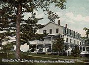
 During the early 1900s, Jefferson was a popular summer resort, boasting one of the largest "grand hotels" in the White Mountains
—the Waumbek, with accommodations for nearly 300 guests, which was destroyed by fire on May 9, 1928. The hotel had its own rail branch, delivering visitors directly to the hotel from Boston
and New York
, without changing trains.
Jefferson had over 30 inns and boarding houses at tourism's peak, reached by several mainline depots including Riverton, Baileys, Meadows, and Highlands. Some of the original station buildings remain, although most have been moved to nearby locations. The tracks were removed in the 1920s. A number of historic, architecturally interesting structures remain from the resort era, and the Waumbek Cottages provided a backdrop for the popular White Mountains Festival of the Arts until 1979. In March 2006, the Waumbek Cottages Historic District was named to the National Register of Historic Places.
 In 1885, a landslide
on the north side of Cherry Mountain demolished the Stanley farm, mortally wounding a worker. Local hotels immediately arranged daily excursions to view the scene, now marked by a roadside historical marker. See New Hampshire Historical Marker 152.
Thaddeus S. C. Lowe
, a local farm boy born in 1832, became a world-famous inventor of aerostats (dirigibles
) and other devices. Consulting President Abraham Lincoln
, he organized a balloon corps during the Civil War
, and went on to invent the ice-making machine, and later the water-gas process which for years ran gas lights in hundreds of cities. His father, Clovis Lowe, had been part owner in 1832 of nearby Low and Burbank's Grant
, which contains much of Mount Adams
and Mount Madison
. See New Hampshire Historical Marker 19.
Jefferson found itself in the national spotlight in 1988 and 1989 when a local volunteer firefighter was charged in connection with dozens of arson fires that had plagued the area. The defendant was acquitted at trial.
 Jefferson is located on U.S. Route 2
between Lancaster
and Randolph
, near the mid-point between the Vermont
and Maine
borders. Set astride the broad Israel River
valley, the town commands remarkable views of the Presidential Range
and other White Mountain summits. Mount Starr King
, with an elevation of 3907 feet (1,190.9 m) above sea level
and named for Thomas Starr King
, is the highest point in town, near the town's northern border. It is regularly traversed by hikers scaling nearby 4006 feet (1,221 m) Mount Waumbek
, one of the "four-thousand footers
" -- the 48 peaks above 4000 feet (1,219.2 m) in New Hampshire. Jefferson lies fully within the Connecticut River
watershed
.
In the past few years, thousands of acres of Jefferson have been sold or donated by private interests to the White Mountain National Forest. These include the Randolph Town Forest, a part of which is within the boundaries of Jefferson, the Silvio O. Conte National Fish and Wildlife Refuge
, and Mount Starr King
.
According to the United States Census Bureau
, the town has a total area of 50.4 square miles (130.5 km²), of which 50.2 sq mi (130 km²) is land and 0.2 sq mi (0.517997622 km²) is water, comprising 0.46% of the town.
 As of the census
of 2000, there were 1,006 people, 407 households, and 295 families residing in the town. The population density
was 20.1 people per square mile (7.7/km²). There were 582 housing units at an average density of 11.6 per square mile (4.5/km²). The racial makeup of the town was 98.31% White, 0.10% Native American, 0.10% Asian, 0.10% Pacific Islander, and 1.39% from two or more races. Hispanic or Latino of any race were 0.10% of the population.
There were 407 households out of which 28.0% had children under the age of 18 living with them, 62.4% were married couples
living together, 5.2% had a female householder with no husband present, and 27.5% were non-families. 20.4% of all households were made up of individuals and 6.9% had someone living alone who was 65 years of age or older. The average household size was 2.47 and the average family size was 2.84.
 In the town the population was spread out with 22.0% under the age of 18, 4.5% from 18 to 24, 27.2% from 25 to 44, 32.4% from 45 to 64, and 13.9% who were 65 years of age or older. The median age was 43 years. For every 100 females there were 103.6 males. For every 100 females age 18 and over, there were 105.0 males.
The median income for a household in the town was $41,089, and the median income for a family was $42,067. Males had a median income of $27,130 versus $21,382 for females. The per capita income
for the town was $19,556. About 4.7% of families and 8.2% of the population were below the poverty line, including 12.0% of those under age 18 and 9.9% of those age 65 or over.
New England town
The New England town is the basic unit of local government in each of the six New England states. Without a direct counterpart in most other U.S. states, New England towns are conceptually similar to civil townships in other states, but are incorporated, possessing powers like cities in other...
in Coos County
Coos County, New Hampshire
-National protected areas:*Umbagog National Wildlife Refuge *Silvio O. Conte National Fish and Wildlife Refuge *White Mountain National Forest -Demographics:...
, New Hampshire
New Hampshire
New Hampshire is a state in the New England region of the northeastern United States of America. The state was named after the southern English county of Hampshire. It is bordered by Massachusetts to the south, Vermont to the west, Maine and the Atlantic Ocean to the east, and the Canadian...
, United States
United States
The United States of America is a federal constitutional republic comprising fifty states and a federal district...
. The population was 1,107 at the 2010 census. It is home to parts of the White Mountain National Forest
White Mountain National Forest
The White Mountain National Forest is a federally-managed forest contained within the White Mountains in the northeastern United States. It was established in 1918 as a result of the Weeks Act of 1911; federal acquisition of land had already begun in 1914. It has a total area of...
in the south and northeast and to two theme parks: Santa's Village
Santa's Village (Jefferson, New Hampshire)
Santa's Village is a Christmas-themed amusement park located in Jefferson, New Hampshire, United States.Most of the 16 rides have Christmas or winter-themed names, such as "Rudy's Rapid Transit Coaster" and "The Great Humbug Adventure". The rides are designed for families with children under age 13...
and Six Gun City. There are also several private campgrounds
Campsite
A campsite or camping pitch is a place used for overnight stay in the outdoors. In British English a campsite is an area, usually divided into a number of pitches, where people can camp overnight using tents or camper vans or caravans; this British English use of the word is synonymous with the...
, motel
Motel
A motor hotel, or motel for short, is a hotel designed for motorists, and usually has a parking area for motor vehicles...
s and inn
INN
InterNetNews is a Usenet news server package, originally released by Rich Salz in 1991, and presented at the Summer 1992 USENIX conference in San Antonio, Texas...
s.
Jefferson is part of the Berlin
Berlin, New Hampshire
Berlin is a city along the Androscoggin River in Coos County in northern New Hampshire, United States. The population was 10,051 at the 2010 census. It includes the village of Cascade. Located on the edge of the White Mountains, the city's boundaries extend into the White Mountain National Forest...
, NH–VT
Vermont
Vermont is a state in the New England region of the northeastern United States of America. The state ranks 43rd in land area, , and 45th in total area. Its population according to the 2010 census, 630,337, is the second smallest in the country, larger only than Wyoming. It is the only New England...
Micropolitan Statistical Area
Berlin micropolitan area
The Berlin Micropolitan Statistical Area is the core based statistical area centered on the urban cluster associated with the city Berlin, New Hampshire in the United States...
.
History
Colony
In politics and history, a colony is a territory under the immediate political control of a state. For colonies in antiquity, city-states would often found their own colonies. Some colonies were historically countries, while others were territories without definite statehood from their inception....
Governor Benning Wentworth
Benning Wentworth
Benning Wentworth was the colonial governor of New Hampshire from 1741 to 1766.-Biography:The eldest child of the John Wentworth who had been Lieutenant Governor, he was born and died in Portsmouth, New Hampshire. Wentworth graduated from Harvard College in 1715...
, the location was so deep in unexplored territory that few took up their claims. One who did was Colonel Joseph Whipple, who cut trails through the forests to build a "manor" house. He named the town "Dartmouth" after William Legge, 2nd Earl of Dartmouth
William Legge, 2nd Earl of Dartmouth
William Legge 2nd Earl of Dartmouth PC, FRS , styled as Viscount Lewisham from 1732 to 1750, was a British statesman who is most remembered for his part in the government before and during the American Revolution....
, the patron of Dartmouth College
Dartmouth College
Dartmouth College is a private, Ivy League university in Hanover, New Hampshire, United States. The institution comprises a liberal arts college, Dartmouth Medical School, Thayer School of Engineering, and the Tuck School of Business, as well as 19 graduate programs in the arts and sciences...
. Brother to William Whipple
William Whipple
William Whipple, Jr. was a signer of the United States Declaration of Independence as a representative of New Hampshire....
, a signer of the Declaration of Independence
Declaration of independence
A declaration of independence is an assertion of the independence of an aspiring state or states. Such places are usually declared from part or all of the territory of another nation or failed nation, or are breakaway territories from within the larger state...
, Colonel Whipple renamed the town "Jefferson" four years prior to Thomas Jefferson
Thomas Jefferson
Thomas Jefferson was the principal author of the United States Declaration of Independence and the Statute of Virginia for Religious Freedom , the third President of the United States and founder of the University of Virginia...
's election as president. The legislature would grant the town a new charter as "Jefferson" in 1796.
In the mid-19th century the boundary with the adjacent township of Kilkenny
Kilkenny, New Hampshire
Kilkenny is a township located in Coos County, New Hampshire, USA. It was granted on June 4, 1774, containing about . As of the 2010 Census, the township had no inhabitants....
was moved so as to include that township's few residents in Jefferson.
White Mountains (New Hampshire)
The White Mountains are a mountain range covering about a quarter of the state of New Hampshire and a small portion of western Maine in the United States. Part of the Appalachian Mountains, they are considered the most rugged mountains in New England...
—the Waumbek, with accommodations for nearly 300 guests, which was destroyed by fire on May 9, 1928. The hotel had its own rail branch, delivering visitors directly to the hotel from Boston
Boston
Boston is the capital of and largest city in Massachusetts, and is one of the oldest cities in the United States. The largest city in New England, Boston is regarded as the unofficial "Capital of New England" for its economic and cultural impact on the entire New England region. The city proper had...
and New York
New York City
New York is the most populous city in the United States and the center of the New York Metropolitan Area, one of the most populous metropolitan areas in the world. New York exerts a significant impact upon global commerce, finance, media, art, fashion, research, technology, education, and...
, without changing trains.
Jefferson had over 30 inns and boarding houses at tourism's peak, reached by several mainline depots including Riverton, Baileys, Meadows, and Highlands. Some of the original station buildings remain, although most have been moved to nearby locations. The tracks were removed in the 1920s. A number of historic, architecturally interesting structures remain from the resort era, and the Waumbek Cottages provided a backdrop for the popular White Mountains Festival of the Arts until 1979. In March 2006, the Waumbek Cottages Historic District was named to the National Register of Historic Places.
Landslide
A landslide or landslip is a geological phenomenon which includes a wide range of ground movement, such as rockfalls, deep failure of slopes and shallow debris flows, which can occur in offshore, coastal and onshore environments...
on the north side of Cherry Mountain demolished the Stanley farm, mortally wounding a worker. Local hotels immediately arranged daily excursions to view the scene, now marked by a roadside historical marker. See New Hampshire Historical Marker 152.
Thaddeus S. C. Lowe
Thaddeus S. C. Lowe
Thaddeus Sobieski Coulincourt Lowe , also known as Professor T. S. C. Lowe, was an American Civil War aeronaut, scientist and inventor, mostly self-educated in the fields of chemistry, meteorology, and aeronautics, and the father of military aerial reconnaissance in the United States...
, a local farm boy born in 1832, became a world-famous inventor of aerostats (dirigibles
Airship
An airship or dirigible is a type of aerostat or "lighter-than-air aircraft" that can be steered and propelled through the air using rudders and propellers or other thrust mechanisms...
) and other devices. Consulting President Abraham Lincoln
Abraham Lincoln
Abraham Lincoln was the 16th President of the United States, serving from March 1861 until his assassination in April 1865. He successfully led his country through a great constitutional, military and moral crisis – the American Civil War – preserving the Union, while ending slavery, and...
, he organized a balloon corps during the Civil War
American Civil War
The American Civil War was a civil war fought in the United States of America. In response to the election of Abraham Lincoln as President of the United States, 11 southern slave states declared their secession from the United States and formed the Confederate States of America ; the other 25...
, and went on to invent the ice-making machine, and later the water-gas process which for years ran gas lights in hundreds of cities. His father, Clovis Lowe, had been part owner in 1832 of nearby Low and Burbank's Grant
Low and Burbank's Grant, New Hampshire
Low and Burbank's Grant is a township located in Coos County, New Hampshire, United States. As of the 2010 census, the grant had a population of 0....
, which contains much of Mount Adams
Mount Adams (New Hampshire)
Mount Adams, elevation above sea level, is a mountain in New Hampshire, the second highest peak in the Northeast United States after its nearby neighbor, Mt. Washington. Located in the northern Presidential Range, Mount Adams was named after John Adams, the second president of the United States....
and Mount Madison
Mount Madison
Mount Madison is a mountain in the Presidential Range of New Hampshire in the United States. It is named after the fourth U.S. President, James Madison....
. See New Hampshire Historical Marker 19.
Jefferson found itself in the national spotlight in 1988 and 1989 when a local volunteer firefighter was charged in connection with dozens of arson fires that had plagued the area. The defendant was acquitted at trial.
Geography
U.S. Route 2
U.S. Route 2 is an east–west U.S. Highway spanning across the northern continental United States. US 2 consists of two segments connected by various roadways in southern Canada...
between Lancaster
Lancaster, New Hampshire
Lancaster is a town in Coos County, New Hampshire, USA, on the Connecticut River named after Lancaster, England. As of the 2010 census, the town population was 3,507, the second largest in the county after Berlin. It is the county seat of Coos County and gateway to the Great North Woods Region...
and Randolph
Randolph, New Hampshire
Randolph is a heavily forested town in Coos County, New Hampshire, U.S., extending from the northern slopes of the White Mountains of the Presidential Range to Berlin , with U.S. Route 2 cutting through the middle...
, near the mid-point between the Vermont
Vermont
Vermont is a state in the New England region of the northeastern United States of America. The state ranks 43rd in land area, , and 45th in total area. Its population according to the 2010 census, 630,337, is the second smallest in the country, larger only than Wyoming. It is the only New England...
and Maine
Maine
Maine is a state in the New England region of the northeastern United States, bordered by the Atlantic Ocean to the east and south, New Hampshire to the west, and the Canadian provinces of Quebec to the northwest and New Brunswick to the northeast. Maine is both the northernmost and easternmost...
borders. Set astride the broad Israel River
Israel River
The Israel River is a river in the White Mountains of New Hampshire. It arises in the township of Low and Burbank's Grant and runs 24 miles generally northwest along U.S. Highway 2, traversing the towns of Jefferson and Lancaster, before joining the Connecticut River...
valley, the town commands remarkable views of the Presidential Range
Presidential Range
The Presidential Range is a mountain range located in the White Mountains of the U.S. state of New Hampshire. Containing the highest peaks of the Whites, its most notable summits are named for American Presidents, followed by prominent public figures of the 18th and 19th centuries.Mt...
and other White Mountain summits. Mount Starr King
Mount Starr King (New Hampshire)
Mount Starr King is a mountain located in Coos County, New Hampshire. The mountain is named after Thomas Starr King , and is part of the Pliny Range of the White Mountains. Mt. Starr King is flanked to the east by Mount Waumbek, and to the northwest by Haystack Mountain...
, with an elevation of 3907 feet (1,190.9 m) above sea level
Sea level
Mean sea level is a measure of the average height of the ocean's surface ; used as a standard in reckoning land elevation...
and named for Thomas Starr King
Thomas Starr King
Thomas Starr King was an American Unitarian and Universalist minister, influential in California politics during the American Civil War. Starr King spoke zealously in favor of the Union and was credited by Abraham Lincoln with preventing California from becoming a separate republic...
, is the highest point in town, near the town's northern border. It is regularly traversed by hikers scaling nearby 4006 feet (1,221 m) Mount Waumbek
Mount Waumbek
Mount Waumbek is a mountain located in Coos County, New Hampshire. The mountain is part of the Pliny Range of the White Mountains. Waumbek is flanked to the northeast by Mount Weeks, to the west by Mount Starr King, and to the southeast by Pliny Mountain...
, one of the "four-thousand footers
Four-thousand footers
The term Four-Thousand Footers refers to a group of forty-eight mountains in New Hampshire at least 4,000 feet above sea level...
" -- the 48 peaks above 4000 feet (1,219.2 m) in New Hampshire. Jefferson lies fully within the Connecticut River
Connecticut River
The Connecticut River is the largest and longest river in New England, and also an American Heritage River. It flows roughly south, starting from the Fourth Connecticut Lake in New Hampshire. After flowing through the remaining Connecticut Lakes and Lake Francis, it defines the border between the...
watershed
Drainage basin
A drainage basin is an extent or an area of land where surface water from rain and melting snow or ice converges to a single point, usually the exit of the basin, where the waters join another waterbody, such as a river, lake, reservoir, estuary, wetland, sea, or ocean...
.
In the past few years, thousands of acres of Jefferson have been sold or donated by private interests to the White Mountain National Forest. These include the Randolph Town Forest, a part of which is within the boundaries of Jefferson, the Silvio O. Conte National Fish and Wildlife Refuge
Silvio O. Conte National Fish and Wildlife Refuge
Silvio O. Conte National Fish and Wildlife Refuge was established in 1997 to conserve, protect and enhance the abundance and diversity of native plant, fish and wildlife species and the ecosystems on which they depend throughout the Connecticut River watershed. The watershed covers large areas of...
, and Mount Starr King
Mount Starr King
Two mountains are named Mount Starr King in honor of Thomas Starr King :* Mount Starr King * Mount Starr King...
.
According to the United States Census Bureau
United States Census Bureau
The United States Census Bureau is the government agency that is responsible for the United States Census. It also gathers other national demographic and economic data...
, the town has a total area of 50.4 square miles (130.5 km²), of which 50.2 sq mi (130 km²) is land and 0.2 sq mi (0.517997622 km²) is water, comprising 0.46% of the town.
Demographics
Census
A census is the procedure of systematically acquiring and recording information about the members of a given population. It is a regularly occurring and official count of a particular population. The term is used mostly in connection with national population and housing censuses; other common...
of 2000, there were 1,006 people, 407 households, and 295 families residing in the town. The population density
Population density
Population density is a measurement of population per unit area or unit volume. It is frequently applied to living organisms, and particularly to humans...
was 20.1 people per square mile (7.7/km²). There were 582 housing units at an average density of 11.6 per square mile (4.5/km²). The racial makeup of the town was 98.31% White, 0.10% Native American, 0.10% Asian, 0.10% Pacific Islander, and 1.39% from two or more races. Hispanic or Latino of any race were 0.10% of the population.
There were 407 households out of which 28.0% had children under the age of 18 living with them, 62.4% were married couples
Marriage
Marriage is a social union or legal contract between people that creates kinship. It is an institution in which interpersonal relationships, usually intimate and sexual, are acknowledged in a variety of ways, depending on the culture or subculture in which it is found...
living together, 5.2% had a female householder with no husband present, and 27.5% were non-families. 20.4% of all households were made up of individuals and 6.9% had someone living alone who was 65 years of age or older. The average household size was 2.47 and the average family size was 2.84.
The median income for a household in the town was $41,089, and the median income for a family was $42,067. Males had a median income of $27,130 versus $21,382 for females. The per capita income
Per capita income
Per capita income or income per person is a measure of mean income within an economic aggregate, such as a country or city. It is calculated by taking a measure of all sources of income in the aggregate and dividing it by the total population...
for the town was $19,556. About 4.7% of families and 8.2% of the population were below the poverty line, including 12.0% of those under age 18 and 9.9% of those age 65 or over.
Sites of interest
- Jefferson Historical Museum, located in the former St. John's Methodist church, on US Route 2, east of village center. From June to October it is open free to the public on Thursday and Sunday afternoons.
- Pondicherry Wildlife Refuge