
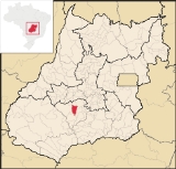
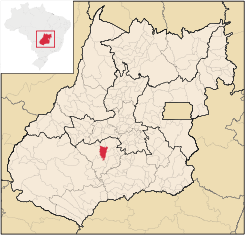
Jandaia
Encyclopedia
| Jandaia | |
|---|---|
| State | Goiás Goiás Goiás is a state of Brazil, located in the central part of the country. The name Goiás comes from the name of an indigenous community... |
| Area: | 864.1 km² |
| Population: | 6,373 (IBGE 2007) |
| Elevation: | 637 m above sea level |
| Postcode (CEP): | 75950-000 |
| Became a city: | 1953 |
| Distance to Goiânia Goiânia -Climate:The city has a tropical wet and dry climate with an average temperature of . There's a wet season, from October to April, and a dry one, from May to September. Annual rainfall is around 1,520 mm.... : |
125 km |
| IBGE statistical microregion: | Vale do Rio dos Bois |
| Website: | Câmara Municipal de Jandaia |
Town
A town is a human settlement larger than a village but smaller than a city. The size a settlement must be in order to be called a "town" varies considerably in different parts of the world, so that, for example, many American "small towns" seem to British people to be no more than villages, while...
and municipality
Municipality
A municipality is essentially an urban administrative division having corporate status and usually powers of self-government. It can also be used to mean the governing body of a municipality. A municipality is a general-purpose administrative subdivision, as opposed to a special-purpose district...
in the eastern portion of the Brazil
Brazil
Brazil , officially the Federative Republic of Brazil , is the largest country in South America. It is the world's fifth largest country, both by geographical area and by population with over 192 million people...
ian state of Goiás
Goiás
Goiás is a state of Brazil, located in the central part of the country. The name Goiás comes from the name of an indigenous community...
.
Location and connections
Jandaia has municipal boundaries with:- Northwest: Palmeiras de GoiásPalmeiras de GoiásPalmeiras de Goiás is a small city and municipality in southestern Goiás state, Brazil.-Location:Palmeiras de Goiás is located in the statistical micro-region of Vale do Rio dos Bois at a distance of 88 kilometers from the state capital, Goiânia. It is 26 kilometers from Cezarina and the important...
- Northeast: PalminópolisPalminópolisPalminópolis is a municipality in eastern Goiás state, Brazil.-Location:Nearby towns are Palmeiras de Goiás, 28 km. to the east, and Turvânia, 22 km. to the north...
- North, South, and Southwest: IndiaraIndiaraIndiara is a small city and municipality in central-south Goiás state, Brazil. Indiara is a large producer of soybeans and cotton.-Location:Indiara is located in the Vale do Rio dos Bois and has municipal boundaries with:*north: Palmeiras de Goiás...
- East and Southeast: ParaúnaParaúnaParaúna is a small town and municipality in southwestern Goiás state, Brazil. It has strange rock formations and is a large producer of cotton and soybeans.-Location:...
Jandaia is 21 kilometers northwest of Indiara
Indiara
Indiara is a small city and municipality in central-south Goiás state, Brazil. Indiara is a large producer of soybeans and cotton.-Location:Indiara is located in the Vale do Rio dos Bois and has municipal boundaries with:*north: Palmeiras de Goiás...
and the junction with the main BR-060 highway. Connections with Goiânia
Goiânia
-Climate:The city has a tropical wet and dry climate with an average temperature of . There's a wet season, from October to April, and a dry one, from May to September. Annual rainfall is around 1,520 mm....
are made by highways BR-060 / Abadia de Goiás
Abadia de Goiás
Abadia de Goiás is a small town and municipality in central Goiás state, Brazil, located on the western edge of the Goiânia metropolitan area.-Geographical Data:The distance to Goiânia is 27 km...
/ Guapó
Guapó
Guapó is a small town and municipality in central Goiás state, Brazil. The population was 13,586 and the total area of the municipality was 517.0 km² .Guapó is part of the Goiânia Microregion...
/ Indiara
Indiara
Indiara is a small city and municipality in central-south Goiás state, Brazil. Indiara is a large producer of soybeans and cotton.-Location:Indiara is located in the Vale do Rio dos Bois and has municipal boundaries with:*north: Palmeiras de Goiás...
/ GO-320.
The climate is tropical humid with an average annual temperature of 27 °C. The main rivers are the Turvo, Capivari, and Galheiros.
Political data
- Mayor: Jerônimo Pereira Lopes
- Vice-mayor: Geni Rosa de Mesquita
- Number of councilmembers: 9
- Total number of eligible voters: 5,626 (12/2007)
Demographic data
- Population density: 7.38 inhab/km² (2007)
- Population in 1980: 10,981 (2,469 urban and 8,512 rural)
- Population in 1991: 6,474 (3,524 urban and 2,950 rural)
- Population in 2003: 6,301 (4,197 urban and 2,104 rural) (1)
- Population in 2007: 6,373 (4,157 urban and 2,216 rural)
(1)Estimated by logistic method
- Population growth rate 1991/1996: 0.82%
- Population growth rate 1991/2000: -0.23%
- Population growth rate 2000/2007: 0.07%
Economy
The economy is based on milk production and sugar cane cultivation. There are small industries producing dairy products, animal feed, and alcoholic beverages. In 2006 there were 75,000 head of cattle. The main crops in planted area were sugarcane (9,140 hectares), corn, and soybeans.Economic Data
- Distilleries: DENUSA - Destilaria Nova União S/A (June/2005)
- Banking Establishments: - Banco do Brasil S.A. - BRADESCO S.A.
Education (2006)
- Schools in activity: 8 with 1,653 students
- Higher education: 0
- Literacy Rate: 87.5%
History
The history of Jandaia is related to the cult of Our Lady of Abadia and Santa Luzia. In 1927 a rancher, Bernardino Vivaldo dos Santos, who had bought lands in the region, donated land for the building of a chapel. More land was bought and houses appeared around the chapel. The settlement was called Água Limpa and it became a district in 1935. With the construction of the new highway, GoiâniaGoiânia
-Climate:The city has a tropical wet and dry climate with an average temperature of . There's a wet season, from October to April, and a dry one, from May to September. Annual rainfall is around 1,520 mm....
to Rio Verde
Rio Verde
Rio Verde can mean the following:-Brazil:* Rio Verde, Goiás* Lucas do Rio Verde* Conceição do Rio Verde* Rio Verde de Mato Grosso-Brazil:29 rivers including:* Verde River...
, the region began to develop. The name was changed to Jandaia, a type of parrot found in the region, and in 1953 it became a municipality, separating from Palmeiras de Goiás
Palmeiras de Goiás
Palmeiras de Goiás is a small city and municipality in southestern Goiás state, Brazil.-Location:Palmeiras de Goiás is located in the statistical micro-region of Vale do Rio dos Bois at a distance of 88 kilometers from the state capital, Goiânia. It is 26 kilometers from Cezarina and the important...
.
Ranking on the Municipal Human Development Index
- MHDI: 0.746
- State ranking: 88 (out of 242 municipalities in 2000)
- National ranking: 1,995 (out of 5,507 municipalities in 2000)
Data are from 2000. For the complete list see Frigoletto.com