
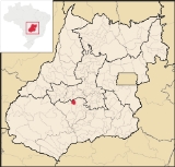
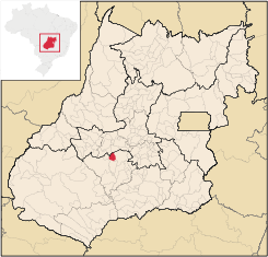
Palminópolis
Encyclopedia
| Palminópolis | |
|---|---|
| State | Goiás Goiás Goiás is a state of Brazil, located in the central part of the country. The name Goiás comes from the name of an indigenous community... |
| Area: | 387,6 km² |
| Population: | 3,622 (IBGE 2007) |
| Elevation: | 719 m above sea level |
| Postcode (CEP): | 75990-000 |
| Became a city: | 1961 |
| Distance to Goiânia Goiânia -Climate:The city has a tropical wet and dry climate with an average temperature of . There's a wet season, from October to April, and a dry one, from May to September. Annual rainfall is around 1,520 mm.... : |
88 km. |
| IBGE statistical microregion: | Vale do Rio dos Bois |
| Website: | n/a |
Municipality
A municipality is essentially an urban administrative division having corporate status and usually powers of self-government. It can also be used to mean the governing body of a municipality. A municipality is a general-purpose administrative subdivision, as opposed to a special-purpose district...
in eastern Goiás
Goiás
Goiás is a state of Brazil, located in the central part of the country. The name Goiás comes from the name of an indigenous community...
state, Brazil
Brazil
Brazil , officially the Federative Republic of Brazil , is the largest country in South America. It is the world's fifth largest country, both by geographical area and by population with over 192 million people...
.
Location
Nearby towns are Palmeiras de GoiásPalmeiras de Goiás
Palmeiras de Goiás is a small city and municipality in southestern Goiás state, Brazil.-Location:Palmeiras de Goiás is located in the statistical micro-region of Vale do Rio dos Bois at a distance of 88 kilometers from the state capital, Goiânia. It is 26 kilometers from Cezarina and the important...
, 28 km. to the east, and Turvânia
Turvânia
Turvânia is a small town and municipality in eastern Goiás state, Brazil.-Location:Turvânia is located west of Goiânia, east of São Luís de Montes Belos....
, 22 km. to the north. The Turvo River
Turvo River (Goiás)
-References:*...
lies to the west.
- Distance to regional center (São Luís de Montes BelosSão Luís de Montes BelosSão Luís de Montes Belos is a small city and municipality in the State of Goiás, Brazil.-Location:It is located in the Anicuns Microregion, 123 kilometers from the state capital, Goiânia, to which it is connected by highway GO-060...
): 41 km. - Highway connections from GoiâniaGoiânia-Climate:The city has a tropical wet and dry climate with an average temperature of . There's a wet season, from October to April, and a dry one, from May to September. Annual rainfall is around 1,520 mm....
: state highway BR-069 west from GoiâniaGoiânia-Climate:The city has a tropical wet and dry climate with an average temperature of . There's a wet season, from October to April, and a dry one, from May to September. Annual rainfall is around 1,520 mm....
, through TrindadeTrindade, GoiásTrindade is a city and municipality in Goiás state, Brazil. It is famous for the religious celebrations held there in July and is now the third most important pilgrimage site in Brazil....
/ GO-050 / Campestre de GoiásCampestre de GoiásCampestre de Goiás is a small town and municipality in central Goiás state, Brazil.-Location:There are municipal boundaries with:*north: Santa Bárbara de Goiás*south: Guapó*east: Trindade*west: Palmeiras de Goiás...
/ GO-156.
Neighboring municipalities: São João da Paraúna
São João da Paraúna
São João da Paraúna is a small town and municipality in western Goiás state, Brazil.-Location:São João is located west of Goiânia, 36 km...
, Palmeiras de Goiás
Palmeiras de Goiás
Palmeiras de Goiás is a small city and municipality in southestern Goiás state, Brazil.-Location:Palmeiras de Goiás is located in the statistical micro-region of Vale do Rio dos Bois at a distance of 88 kilometers from the state capital, Goiânia. It is 26 kilometers from Cezarina and the important...
, Jandaia
Jandaia
Jandaia is a small town and municipality in the eastern portion of the Brazilian state of Goiás.-Location and connections:Jandaia has municipal boundaries with:*Northwest: Palmeiras de Goiás*Northeast: Palminópolis...
, Paraúna
Paraúna
Paraúna is a small town and municipality in southwestern Goiás state, Brazil. It has strange rock formations and is a large producer of cotton and soybeans.-Location:...
and Turvânia
Turvânia
Turvânia is a small town and municipality in eastern Goiás state, Brazil.-Location:Turvânia is located west of Goiânia, east of São Luís de Montes Belos....
Political Information
- Mayor: Erisval Vicente Santana (January 2005)
- City council: 9
- Eligible voters: 3,294 (December 2007)
Demographic Information
- Population density: 9.34 inhab/km² (2007)
- Urban population: 2,421 (2007)
- Rural population: 1,201 (2007)
- Population growth: a loss of about 800 people since 1980
Economic Information
The economy is based on agriculture, cattle raising, services, public administration, and small transformation industry. There is one dairy and one meat packing plant (frigorífico).- Industrial units: 6 ( June 2007)
- Commercial units: 37 ( August 2007)
- Dairy: Indústria e Comércio de Laticínios Saltador Ltda. (22/05/2006)
- Meat-packing plant: Coop. Agrop. dos Prod. Organ. do Estado de Goiás. (22/05/2006)
- Motor vehicles: 361 automobiles and pickup trucks (2007), which gave a ration of 10 inhabitants for each motor vehicle.
- Cattle herd: 48,660 head
- Main crops: rice, rubber, corn, soybeans (800 hectares), and tomatoes.
- Number of farms: 423
- Agricultural area: 44,756
- Planted area: 4,100 ha.
- Area of natural pasture: 33,678 ha.
- Persons employed in agriculture: 2,120
Education (2006)
- Schools: 4 with 1,018 students
- Higher education: none
- Adult literacy rate: 87.9% (2000) (national average was 86.4%)
Health (2007)
- Hospitals: 1
- Hospital beds: 20
- Ambulatory clinics: 3
- Infant mortality rate: 22.64 (2000) (national average was 33.0)
Ranking on the Municipal Human Development Index
Human Development Index
The Human Development Index is a composite statistic used to rank countries by level of "human development" and separate "very high human development", "high human development", "medium human development", and "low human development" countries...
- MHDI: 0.753
- State ranking: 70 (out of 242 municipalities)
- National ranking: 1,797 (out of 5,507 municipalities)
Data are from 2000. For the complete list see Frigoletto.com
History
Palminópolis began in 1949 when lands belong to a cattle ranch were distributed to made lots. The first settlement was called São Bento, which was later changed to Palminópolis due to the proximity of Palmeiras de GoiásPalmeiras de Goiás
Palmeiras de Goiás is a small city and municipality in southestern Goiás state, Brazil.-Location:Palmeiras de Goiás is located in the statistical micro-region of Vale do Rio dos Bois at a distance of 88 kilometers from the state capital, Goiânia. It is 26 kilometers from Cezarina and the important...
. In 1953 it became a district of Palmeiras de Goiás, separating in 1961 to become a municipality.