

Jacksons Creek (Victoria)
Encyclopedia
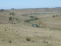
Jacksons Creek is a watercourse in the Yarra-Maribyrnong catchment area, north of Melbourne
in Victoria
, which arises from the confluence of a number of smaller streams draining the southern slopes of the Mount Macedon
range being part of the Great Dividing Range
.
Jacksons Creek flows generally south to become the second longest of the two main tributaries of the Maribyrnong River
, the other being Deep Creek
. In its upper reaches the creek flows east in a broad shallow valley in the Riddells Creek
area, before turning generally southwards to enter the deeper, narrower valley that characterises the remainder of the watercourse. The creek then flows through the town of Sunbury
eventually to join with Deep Creek near Bulla
, where the two waterways form the Maribyrnong River. The deep and relatively narrow valley cut by the creek in its southward course through the surrounding basalt
plains is particularly prominent at such localities as Emu Bottom and the Organ Pipes National Park
.
, in Surrey
, England
when it was established in 1857. or alternatively the Upper Maribyrnong River,. Maribyrnong Creek,
Maribyrnong River West Branch or Maribyrnong River Right Branch. the incised meanders of Jackson's Creek demonstrate the downcutting of the Newer Volcanics and have formed rapids and small falls, along with outcrops of columnar basalts and tessellated pavements, for example at the Organ Pipes National Park
near the Calder Freeway
, a unique display of basaltic columns so named because they look like organ pipes. A bluestone flour mill near the falls south of Sunbury harnessed the makor drop in river levels.
The named tributaries of the river, ordered upstream, are:
the tributaries of Jacksons Creek and Deep Creek
conjoin to form the Maribyrnong River
.
Melbourne
Melbourne is the capital and most populous city in the state of Victoria, and the second most populous city in Australia. The Melbourne City Centre is the hub of the greater metropolitan area and the Census statistical division—of which "Melbourne" is the common name. As of June 2009, the greater...
in Victoria
Victoria (Australia)
Victoria is the second most populous state in Australia. Geographically the smallest mainland state, Victoria is bordered by New South Wales, South Australia, and Tasmania on Boundary Islet to the north, west and south respectively....
, which arises from the confluence of a number of smaller streams draining the southern slopes of the Mount Macedon
Mount Macedon, Victoria
Mount Macedon is a small town located northwest of Melbourne in the Australian state of Victoria. It is situated on the side of the mountain of the same name, known as Geboor by the indigenous Wurundjeri people, which rises to above sea level. At the 2006 census, Mount Macedon had a population...
range being part of the Great Dividing Range
Great Dividing Range
The Great Dividing Range, or the Eastern Highlands, is Australia's most substantial mountain range and the third longest in the world. The range stretches more than 3,500 km from Dauan Island off the northeastern tip of Queensland, running the entire length of the eastern coastline through...
.
Jacksons Creek flows generally south to become the second longest of the two main tributaries of the Maribyrnong River
Maribyrnong river
The Maribyrnong River rises about 50 km north of Melbourne, Victoria , near Mount Macedon. It flows generally southward and combines with the Yarra River to flow into Port Phillip....
, the other being Deep Creek
Deep Creek (Victoria)
Deep Creek is a watercourse in the Yarra-Maribyrnong catchment area, north of Melbourne in Victoria, which arises from the confluence of a number of smaller streams draining the north eastern slopes of the Mount Macedon range and the southern slopes of the Cobaw range, both ranges being...
. In its upper reaches the creek flows east in a broad shallow valley in the Riddells Creek
Riddells Creek, Victoria
Riddells Creek is a town in Victoria, Australia, located in the Shire of Macedon Ranges. Riddells Creek is also the name of the main watercourse which flows through the township, and which is a tributary of Jacksons Creek to the south. The town is served by Riddells Creek railway station on the...
area, before turning generally southwards to enter the deeper, narrower valley that characterises the remainder of the watercourse. The creek then flows through the town of Sunbury
Sunbury, Victoria
Sunbury is a regional city, located north-west of Melbourne's central business district, in the state of Victoria, Australia. Its Local Government Area is the City of Hume. At the 2006 Census, Sunbury had a population of 31,000...
eventually to join with Deep Creek near Bulla
Bulla, Victoria
Bulla is a locality and township in Melbourne, Victoria, Australia, north-west from Melbourne's central business district. It is adjacent to the Melbourne metropolitan area. Its Local Government Area is the City of Hume...
, where the two waterways form the Maribyrnong River. The deep and relatively narrow valley cut by the creek in its southward course through the surrounding basalt
Basalt
Basalt is a common extrusive volcanic rock. It is usually grey to black and fine-grained due to rapid cooling of lava at the surface of a planet. It may be porphyritic containing larger crystals in a fine matrix, or vesicular, or frothy scoria. Unweathered basalt is black or grey...
plains is particularly prominent at such localities as Emu Bottom and the Organ Pipes National Park
Organ Pipes National Park
The Organ Pipes National Park , a protected area, is located in Victoria, Australia. It was established with the focus on conservation of the native flora and fauna, and preservation of the geological features in the Jackson Creek, a part of the Maribyrnong valley, north-west of Melbourne...
.
Etymology and Alternate Names
The creek was named after the early settlers William Jackson and and his brother Samuel, who named the township Sunbury, after Sunbury-on-ThamesSunbury-on-Thames
Sunbury-on-Thames, also known as Sunbury, is a town in the Surrey borough of Spelthorne, England, and part of the London commuter belt. It is located 16 miles southwest of central London and bordered by Feltham and Hampton, flanked on the south by the River Thames.-History:The earliest evidence of...
, in Surrey
Surrey
Surrey is a county in the South East of England and is one of the Home Counties. The county borders Greater London, Kent, East Sussex, West Sussex, Hampshire and Berkshire. The historic county town is Guildford. Surrey County Council sits at Kingston upon Thames, although this has been part of...
, England
England
England is a country that is part of the United Kingdom. It shares land borders with Scotland to the north and Wales to the west; the Irish Sea is to the north west, the Celtic Sea to the south west, with the North Sea to the east and the English Channel to the south separating it from continental...
when it was established in 1857. or alternatively the Upper Maribyrnong River,. Maribyrnong Creek,
Maribyrnong River West Branch or Maribyrnong River Right Branch. the incised meanders of Jackson's Creek demonstrate the downcutting of the Newer Volcanics and have formed rapids and small falls, along with outcrops of columnar basalts and tessellated pavements, for example at the Organ Pipes National Park
Organ Pipes National Park
The Organ Pipes National Park , a protected area, is located in Victoria, Australia. It was established with the focus on conservation of the native flora and fauna, and preservation of the geological features in the Jackson Creek, a part of the Maribyrnong valley, north-west of Melbourne...
near the Calder Freeway
Calder Freeway
Calder Freeway is a freeway linking Melbourne to Ravenswood South in Victoria, Australia, superseding stretches of the Calder Highway. Originally just a short spur of the Tullamarine Freeway linking to the Calder Highway in Keilor in suburban Melbourne, it has been extended in phases to Ravenswood...
, a unique display of basaltic columns so named because they look like organ pipes. A bluestone flour mill near the falls south of Sunbury harnessed the makor drop in river levels.
The named tributaries of the river, ordered upstream, are:
- Deep CreekDeep Creek (Victoria)Deep Creek is a watercourse in the Yarra-Maribyrnong catchment area, north of Melbourne in Victoria, which arises from the confluence of a number of smaller streams draining the north eastern slopes of the Mount Macedon range and the southern slopes of the Cobaw range, both ranges being...
- Kismet Creek
- Harpers Creek
- Riddells Creek
- Gisborne Creek
- Slaty Creek
- Distill Creek
- Macedon Creek
Lower reaches
To the west of Melbourne AirportMelbourne Airport
Melbourne Airport , also known as Tullamarine Airport, is the primary airport serving the city of Melbourne and the second busiest in Australia. It was opened in 1970 to replace the nearby Essendon Airport. Melbourne Airport is the sole international airport of the four airports serving the...
the tributaries of Jacksons Creek and Deep Creek
Deep Creek (Victoria)
Deep Creek is a watercourse in the Yarra-Maribyrnong catchment area, north of Melbourne in Victoria, which arises from the confluence of a number of smaller streams draining the north eastern slopes of the Mount Macedon range and the southern slopes of the Cobaw range, both ranges being...
conjoin to form the Maribyrnong River
Maribyrnong river
The Maribyrnong River rises about 50 km north of Melbourne, Victoria , near Mount Macedon. It flows generally southward and combines with the Yarra River to flow into Port Phillip....
.
Crossings
Named and other significant bridges and crossing points along Jacksons Creek include but are not limited to the following:- Keilor Bridge (early riveted wrought iron box girder and bluestone bridge built 1869, replacing an earlier timber bridge)
- Calder FreewayCalder FreewayCalder Freeway is a freeway linking Melbourne to Ravenswood South in Victoria, Australia, superseding stretches of the Calder Highway. Originally just a short spur of the Tullamarine Freeway linking to the Calder Highway in Keilor in suburban Melbourne, it has been extended in phases to Ravenswood...
Bridge - Arundel Road Bridge (timber trestle bridge constructed for Soldier SettementSoldier settlement (Australia)Soldier settlement refers to the occupation and settlement of land throughout parts of Australia by returning discharged soldiers under schemes administered by the State Governments after World Wars I and II.- World War I :...
Scheme built 1906-7, closed to vehicles 1989, closed to pedestrians 2007) - Arundel Road Bridge (1989) - local road
- Holden Bridge (early concrete beam bridge on Bulla Diggers Rest Road)
- Jacksons Creek Bridge Sunbury (historic twin arch bluestone bridge)
- Sunbury railway viaduct (constructed 1859 for Bendigo Rail Line)
- Black Hill Bridge Settlement Road
- Riddlells Creek railway bridge (large bluesotne arch carying Bendigo Rail Line)
- Jacksons Creek Bridge (Riddell Road)
- Old Jacksons Creek Bridge (pedestrians only)
- Calder Freeway
- Gisborne - Kilmore Road
- Aitken Street
- Waterloo Flat Road