

Deep Creek (Victoria)
Encyclopedia
Deep Creek is a watercourse in the Yarra-Maribyrnong catchment area, north of Melbourne
in Victoria
, which arises from the confluence of a number of smaller streams draining the north eastern slopes of the Mount Macedon
range and the southern slopes of the Cobaw
range, both ranges being constituent parts of the Great Dividing Range
.
Deep Creek flows generally south to become the longest of the two main tributaries of the Maribyrnong River
, the other being Jacksons Creek
. In its upper reaches the creek flows east in a broad shallow valley in the Lancefield
area, before turning generally southwards to enter the deeper, narrower valley that characterises the remainder of the watercourse. The creek then flows east again for a number of kilometres before resuming its southward course at Darraweit Guim
, eventually to join with Jacksons Creek near Bulla
, where the two waterways form the Maribyrnong River. The deep and relatively narrow valley cut by the creek in its southward course through the surrounding basalt
plains is particularly prominent at such localities as Darraweit Guim, Konagaderra and Bulla.
Being unregulated by major dams or diversions, water levels in the creek show great seasonal variation. Recently, Deep Creek has flowed only seasonally along most of its length, although significant pools and stretches of water remain all year, some of which are locally noted swimming holes.
, also the name of a small town located on the river. The name Deep Creek may refer to the deep valley the watercourse has cut through the plains north of Melbourne or the deep pools which have formed in the riverbed.
 Named bridges and other significant crossing points along Deep Creek, ordered upstream, include but are not limited to:
Melbourne
Melbourne is the capital and most populous city in the state of Victoria, and the second most populous city in Australia. The Melbourne City Centre is the hub of the greater metropolitan area and the Census statistical division—of which "Melbourne" is the common name. As of June 2009, the greater...
in Victoria
Victoria (Australia)
Victoria is the second most populous state in Australia. Geographically the smallest mainland state, Victoria is bordered by New South Wales, South Australia, and Tasmania on Boundary Islet to the north, west and south respectively....
, which arises from the confluence of a number of smaller streams draining the north eastern slopes of the Mount Macedon
Mount Macedon, Victoria
Mount Macedon is a small town located northwest of Melbourne in the Australian state of Victoria. It is situated on the side of the mountain of the same name, known as Geboor by the indigenous Wurundjeri people, which rises to above sea level. At the 2006 census, Mount Macedon had a population...
range and the southern slopes of the Cobaw
Cobaw, Victoria
Cobaw is a locality in the Macedon Ranges Shire, in Victoria, situated on Dry Creek.The Cobaw area formerly had its own Post Office and State school, now closed.Cobaw Post Office opened on 1 December 1887 and closed in 1952....
range, both ranges being constituent parts of the Great Dividing Range
Great Dividing Range
The Great Dividing Range, or the Eastern Highlands, is Australia's most substantial mountain range and the third longest in the world. The range stretches more than 3,500 km from Dauan Island off the northeastern tip of Queensland, running the entire length of the eastern coastline through...
.
Deep Creek flows generally south to become the longest of the two main tributaries of the Maribyrnong River
Maribyrnong river
The Maribyrnong River rises about 50 km north of Melbourne, Victoria , near Mount Macedon. It flows generally southward and combines with the Yarra River to flow into Port Phillip....
, the other being Jacksons Creek
Jacksons Creek (Victoria)
Jacksons Creek is a watercourse in the Yarra-Maribyrnong catchment area, north of Melbourne in Victoria, which arises from the confluence of a number of smaller streams draining the southern slopes of the Mount Macedon range being part of the Great Dividing Range.Jacksons Creek flows generally...
. In its upper reaches the creek flows east in a broad shallow valley in the Lancefield
Lancefield, Victoria
Lancefield is a town in the Shire of Macedon Ranges Local government area in Victoria, Australia. The town is located north of the state capital, Melbourne and had a population of 1,184 at the 2006 census.-History:...
area, before turning generally southwards to enter the deeper, narrower valley that characterises the remainder of the watercourse. The creek then flows east again for a number of kilometres before resuming its southward course at Darraweit Guim
Darraweit Guim, Victoria
Darraweit Guim is a Victorian town situated on Deep Creek, which rises in the hills beyond Romsey on the edge of the Shire of Macedon Ranges near the shire's boundary with the Shire of Mitchell. In 1992 the town had an approximate population of 300 with approximately 120 homes and a local school...
, eventually to join with Jacksons Creek near Bulla
Bulla, Victoria
Bulla is a locality and township in Melbourne, Victoria, Australia, north-west from Melbourne's central business district. It is adjacent to the Melbourne metropolitan area. Its Local Government Area is the City of Hume...
, where the two waterways form the Maribyrnong River. The deep and relatively narrow valley cut by the creek in its southward course through the surrounding basalt
Basalt
Basalt is a common extrusive volcanic rock. It is usually grey to black and fine-grained due to rapid cooling of lava at the surface of a planet. It may be porphyritic containing larger crystals in a fine matrix, or vesicular, or frothy scoria. Unweathered basalt is black or grey...
plains is particularly prominent at such localities as Darraweit Guim, Konagaderra and Bulla.
Being unregulated by major dams or diversions, water levels in the creek show great seasonal variation. Recently, Deep Creek has flowed only seasonally along most of its length, although significant pools and stretches of water remain all year, some of which are locally noted swimming holes.
Etymology and Alternate Names
The creek was originally considered to be the extension of the Maribyrnong River, and as such has also been known as Saltwater River (an original name for the Maribyrnong) or alternatively the Upper Maribyrnong River, Maribyrnong Creek, Maribyrnong River East Branch or Maribyrnong River Left Branch. Another possible name for the river is Darraweit GuimDarraweit Guim, Victoria
Darraweit Guim is a Victorian town situated on Deep Creek, which rises in the hills beyond Romsey on the edge of the Shire of Macedon Ranges near the shire's boundary with the Shire of Mitchell. In 1992 the town had an approximate population of 300 with approximately 120 homes and a local school...
, also the name of a small town located on the river. The name Deep Creek may refer to the deep valley the watercourse has cut through the plains north of Melbourne or the deep pools which have formed in the riverbed.
Geography
The named tributaries of the river, ordered upstream, are:- Jacksons CreekJacksons Creek (Victoria)Jacksons Creek is a watercourse in the Yarra-Maribyrnong catchment area, north of Melbourne in Victoria, which arises from the confluence of a number of smaller streams draining the southern slopes of the Mount Macedon range being part of the Great Dividing Range.Jacksons Creek flows generally...
- Emu Creek
- Konagaderra Creek
- Boyd Creek
- Five Mile Creek
- Long Gully Creek
- Dry Creek
- Monument Creek
- Garden Hut Creek
Crossings
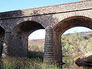
- Bulla BridgeBulla BridgeBulla Bridge is a four span bluestone arched bridge over Deep Creek in the town of Bulla, north east of Melbourne. It was constructed in 1869 by McBurnie and Ramsden, for the Shire of Bulla to a design of Scottish-born engineer John C Climie and replaced a timber bridge built in about 1859. The...
(current triple arch bluestone bridge built 1869, replacing an earlier timber bridge) - Wildwood Rd
- Konagaderra Rd
- McCabes Bridge (Stockdale Rd)
- Darraweit Valley Rd
- Chintin Rd
- Gallaghers Ford (Joyces Rd)
- Dalys Bridge (Woodend – Wallan Rd)
- Sheehans Crossing bridge (Sheehans Rd)
- Forbes Bridge (Forbes Rd)
- Doggetts Bridge (Lancefield – Kilmore Rd)
- Musteys Bridge (Lancefield – Tooborac Rd)
- Linehans Bridge (Baynton Rd) (replaced by a low-level causeway during the 1990s, the old bridge is closed and derelict)
- Twin Bridges (Kyneton – Lancefield Rd)
- White Bridge (Whitebridge Rd)