

Ivan Asen Point
Encyclopedia
Osmar Strait
Osmar Strait is the wide strait in the South Shetland Islands, Antarctica between Smith Island to the northwest and Low Island to the southeast.The strait is named after the settlement of Osmar in northeastern Bulgaria.-Location:...
from the southeast coast of Smith Island
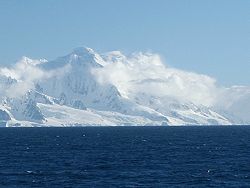
Smith Island (South Shetland Islands)
Smith Island is long and wide, lying west of Deception Island in the South Shetland Islands of the British Antarctic Territory. Surface area ....
in the South Shetland Islands
South Shetland Islands
The South Shetland Islands are a group of Antarctic islands, lying about north of the Antarctic Peninsula, with a total area of . By the Antarctic Treaty of 1959, the Islands' sovereignty is neither recognized nor disputed by the signatories and they are free for use by any signatory for...
, Antarctica and forming the south side of the entrance to an 1.15 km wide cove indenting the coast for 980 m, and named Ivan Asen Cove (63°01′25"S 62°31′12"W) in association with the point.
The point is named after Czar
Tsar
Tsar is a title used to designate certain European Slavic monarchs or supreme rulers. As a system of government in the Tsardom of Russia and Russian Empire, it is known as Tsarist autocracy, or Tsarism...
Ivan Asen II of Bulgaria
Ivan Asen II of Bulgaria
-Early rule:He was a son of Ivan Asen I of Bulgaria and Elena . Elena, who survived until after 1235, is sometimes alleged to be a daughter of Stefan Nemanja of Serbia, but this relationship is questionable and would have caused various canonical impediments to marriages between various descendants...
, 1218-1241 AD.
Location
The point is located at 63°01′43"S 62°31′09"W which is 12.5 km northeast of Cape JamesCape James
Cape James is a cape which forms the south tip of Smith Island in the South Shetland Islands, Antarctica. The name appears on a chart based upon the 1828-31 British naval expedition under Captain Henry Foster, and is now well established in international usage.-Location:The point is located at ...
, 20.5 km southwest of Cape Smith
Cape Smith
Cape Smith is a cape forming the north end of Smith Island in the South Shetland Islands, Antarctica. The discovery of the South Shetland Islands was first reported in 1819 by Captain William Smith, for whom the cape is named.-Location:...
, 3.8 km south-southeast of the island’s summit Mount Foster
Mount Foster
Mount Foster is a peak rising to 2105 m in the Imeon Range on Smith Island in the South Shetland Islands, Antarctica. It is the highest point of the South Shetland Islands archipelago....
(2105 m), and 3.45 km southeast of Slaveykov Peak
Slaveykov Peak
Slaveykov Peak is the sharp peak rising to 1760 m in Imeon Range on Smith Island in the South Shetland Islands, Antarctica. The feature is situated 2 km southwest of the summit Mount Foster, to which it is linked by Zavet Saddle, 1.12 km north-northeast of Neofit Peak, 2.4 km...
(Bulgarian mapping in 2009).
See also
- Smith IslandSmith Island (South Shetland Islands)Smith Island is long and wide, lying west of Deception Island in the South Shetland Islands of the British Antarctic Territory. Surface area ....
- List of Bulgarian toponyms in Antarctica
Map
- L.L. Ivanov. Antarctica: Livingston Island and Greenwich, Robert, Snow and Smith Islands. Scale 1:120000 topographic map. Troyan: Manfred Wörner Foundation, 2009. ISBN 978-954-92032-6-4