

Cape James
Encyclopedia
Smith Island (South Shetland Islands)
Smith Island is long and wide, lying west of Deception Island in the South Shetland Islands of the British Antarctic Territory. Surface area ....
in the South Shetland Islands
South Shetland Islands
The South Shetland Islands are a group of Antarctic islands, lying about north of the Antarctic Peninsula, with a total area of . By the Antarctic Treaty of 1959, the Islands' sovereignty is neither recognized nor disputed by the signatories and they are free for use by any signatory for...
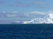
, Antarctica. The name appears on a chart based upon the 1828-31 British naval expedition under Captain Henry Foster
Henry Foster (scientist)
Henry Foster was a British naval officer who took part in expeditions to the Arctic and Antarctic and made various notable scientific observations....
, and is now well established in international usage.
Location
The point is located at 63°05′50"S 62°43′01"W which is 4.5 km south-southwest of Elin Pelin PointElin Pelin Point
Elin Pelin Point is a point on the northwest coast of Smith Island, South Shetland Islands situated 4.6 km north-northeast of Cape James and 4.8 km south-southwest of Lista Point. Bulgarian early mapping in 2009. Named after the Bulgarian writer Elin Pelin .-Map:* L.L. Ivanov. Scale...
, 6.8 km southwest of Organa Peak
Organa Peak
Organa Peak is a peak rising to 1270 m in Imeon Range on Smith Island, South Shetland Islands. Situated 6.8 km northeast of Cape James, and 1.85 km south-southwest of Riggs Peak. Overlooking Letnitsa Glacier to the east and southeast, and Kremena Ice Piedmont to the south. Bulgarian...
, 3.55 km west-southwest of Suhindol Point
Suhindol Point
Suhindol Point is a point on the southeast coast of Smith Island, South Shetland Islands projecting 450 m southeastwards into Osmar Strait, and situated 3.54 km east-northeast of Cape James and 4.3 km southwest of Dupnitsa Point. Bulgarian early mapping in 2009. Named after the town of...
and 29.5 km northwest of Low Island
Low Island (South Shetland Islands)
Low Island or Isla Baja, historical names Jameson Island or Jamesons Island is an island long and wide, southeast of Smith Island, in the South Shetland Islands. The island is located at and is separated from Smith Island by Osmar Strait. Low Island was so named because of its low elevation...
(Bulgarian mapping in 2009).
Map
- L.L. Ivanov. Antarctica: Livingston Island and Greenwich, Robert, Snow and Smith Islands. Scale 1:120000 topographic map. Troyan: Manfred Wörner Foundation, 2009. ISBN 978-954-92032-6-4