
Mount Foster
Encyclopedia
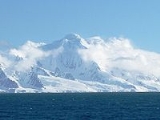
Mount Foster is a peak rising to 2105 m in the Imeon Range
on Smith Island
in the South Shetland Islands
, Antarctica. It is the highest point of the South Shetland Islands archipelago.
Mount Foster has triple peaks of which Mount Foster proper is the southernmost, the central one is Evlogi Peak
(2090 m), and the northern one is Antim Peak
(2070 m). The first ascent was made by Greg Landreth and team on 29 January 1996.
The feature is named after Captain Henry Foster
, commander of HMS Chanticleer
who explored the South Shetlands in 1829.
to Slaveykov Peak
to the southwest and surmounts Bistra Glacier
to the west, Chuprene Glacier
to the north-northwest, Rupite Glacier
to the east, Landreth Glacier
to the southeast and Dragoman Glacier
to the south-southeast. The peak is located 5.45 km northeast of Riggs Peak
, 2.78 km south-southeast of Garmen Point
, 7.64 km southwest of Mount Pisgah and 3.86 km north-northwest of Ivan Asen Point
(Bulgarian mapping in 2009).
Imeon Range
Imeon Range is a mountain range occupying the interior of Smith Island in the South Shetland Islands, Antarctica. Extending 30 km in southwest-northeast direction between Cape James and Cape Smith, and 6.8 km wide...
on Smith Island
Smith Island (South Shetland Islands)
Smith Island is long and wide, lying west of Deception Island in the South Shetland Islands of the British Antarctic Territory. Surface area ....
in the South Shetland Islands
South Shetland Islands
The South Shetland Islands are a group of Antarctic islands, lying about north of the Antarctic Peninsula, with a total area of . By the Antarctic Treaty of 1959, the Islands' sovereignty is neither recognized nor disputed by the signatories and they are free for use by any signatory for...
, Antarctica. It is the highest point of the South Shetland Islands archipelago.
Mount Foster has triple peaks of which Mount Foster proper is the southernmost, the central one is Evlogi Peak
Evlogi Peak
Evlogi Peak is a peak rising to 2090 m in Imeon Range on Smith Island, South Shetland Islands. Situated 1 km north-northeast of the summit Mount Foster, and 1.3 km southwest of Antim Peak, with intervening saddles of elevation 1950 and 1800 m respectively...
(2090 m), and the northern one is Antim Peak
Antim Peak
Antim Peak is the ice-covered peak rising to 2080 m in Imeon Range on Smith Island in the South Shetland Islands, Antarctica. Situated 2.25nbsp;km and 1.3 km northeast of the summit Mount Foster and Evlogi Peak respectively, 5.4 km south-southwest of Mount Pisgah, 16 km...
(2070 m). The first ascent was made by Greg Landreth and team on 29 January 1996.
The feature is named after Captain Henry Foster
Henry Foster (scientist)
Henry Foster was a British naval officer who took part in expeditions to the Arctic and Antarctic and made various notable scientific observations....
, commander of HMS Chanticleer
HMS Chanticleer (1808)
HMS Chanticleer was a Cherokee-class 10-gun brig of the Royal Navy. Chanticleer was launched on 26 July 1808. She served in European waters during the Napoleonic Wars and was paid off and laid up at Sheerness in July 1816. She was chosen for an 1828 scientific voyage to the Pacific Ocean...
who explored the South Shetlands in 1829.
Location
Mount Foster is linked by Zavet SaddleZavet Saddle
Zavet Saddle is a saddle of elevation 1410 m in Imeon Range on Smith Island, South Shetland Islands bounded by Slaveykov Peak to the southwest and the summit Mount Foster to the northeast. Overlooking Dragoman Glacier to the southeast and Bistra Glacier to the northwest. The feature is named...
to Slaveykov Peak
Slaveykov Peak
Slaveykov Peak is the sharp peak rising to 1760 m in Imeon Range on Smith Island in the South Shetland Islands, Antarctica. The feature is situated 2 km southwest of the summit Mount Foster, to which it is linked by Zavet Saddle, 1.12 km north-northeast of Neofit Peak, 2.4 km...
to the southwest and surmounts Bistra Glacier
Bistra Glacier
Bistra Glacier is the 1.75 km long and 750 m wide glacier in Imeon Range on Smith Island in the South Shetland Islands, Antarctica. Draining the west slopes of Mount Foster and the north slopes of Slaveykov Peak, and flowing northwestwards of Zavet Saddle to enter Drake Passage south of...
to the west, Chuprene Glacier
Chuprene Glacier
Chuprene Glacier is a 4 km long glacier on Smith Island, South Shetland Islands draining the northwest slopes of Imeon Range. Flowing southwest of Drinov Peak and Popovo Saddle, and west of Slatina Peak and Varshets Saddle southwestward along the northwest slopes of Antim Peak and Evlogi...
to the north-northwest, Rupite Glacier
Rupite Glacier
Rupite Glacier is a 2.9 km long glacier on Smith Island, South Shetland Islands draining the southeast slopes of Imeon Range east of the summit Mount Foster and southeast of Evlogi Peak. Flowing southeastward into Osmar Strait. Bulgarian early mapping in 2008. Named after the settlement...
to the east, Landreth Glacier
Landreth Glacier
Landreth Glacier is the steep 2.3 km long and 600 m wide glacier on the southeast side of Imeon Range, Smith Island in the South Shetland Islands, Antarctica, which is draining southeastwards from Mount Foster between the side ridges separating it from Rupite Glacier to the north and Dragoman...
to the southeast and Dragoman Glacier
Dragoman Glacier
Dragoman Glacier is a 2.6 km long glacier on Smith Island, South Shetland Islands draining the southeast slopes of Imeon Range southeast of Zavet Saddle and south of the summit Mount Foster. Flowing southeastward into Ivan Asen Cove, Osmar Strait. Bulgarian early mapping in 2009. Named...
to the south-southeast. The peak is located 5.45 km northeast of Riggs Peak
Riggs Peak
Riggs Peak is a peak rising to 1690 m in Imeon Range on Smith Island, South Shetland Islands. Situated 2.38 km southwest of Neofit Peak, 5.4 km southwest of the summit Mount Foster, and 8.6 km northeast of Cape James. Overlooking Letnitsa Glacier to the south, and Gramada Glacier...
, 2.78 km south-southeast of Garmen Point
Garmen Point
Garmen Point is a point on the northwest coast of Smith Island, South Shetland Islands situated 13.65 km north-northeast of Cape James, 6.12 km south-southwest of Markeli Point and 19.65 km southwest of Cape Smith. Formed by an offshoot of Mount Foster. Bulgarian early mapping in...
, 7.64 km southwest of Mount Pisgah and 3.86 km north-northwest of Ivan Asen Point
Ivan Asen Point
Ivan Asen Point is a narrow rocky point projecting 680 m into Osmar Strait from the southeast coast of Smith Island in the South Shetland Islands, Antarctica and forming the south side of the entrance to an 1.15 km wide cove indenting the coast for 980 m, and named Ivan Asen Cove ...
(Bulgarian mapping in 2009).
Reference
- Composite Gazetteer of Antarctica: Mount Foster