

Smith Island (South Shetland Islands)
Encyclopedia
Smith Island is 20 miles (32.2 km) long and 5 miles (8 km) wide, lying 45 miles (72.4 km) west of Deception Island in the South Shetland Islands
of the British Antarctic Territory
. Surface area 148 square kilometres (57.1 sq mi).
The discovery of the South Shetland Islands was first reported in 1819 by Capt. William Smith
, for whom the island is named. This island was known to both American and British sealers
as early as 1820, and the name Smith has been well established in international usage for over 100 years, although in Russian literature it is often referred to as Borodino Island, sometimes marked as Borodino (Smith) Island.
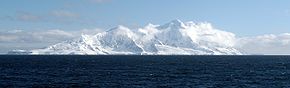 The island hosts no research stations or camps, and is seldom visited by scientists or mountaineers. Its interior is entirelly occupied by Imeon Range
rising to 2105 m (6,906 ft) (Mount Foster
). The first detailed topographic mapping of the island was made by the Antarctic Place-names Commission
and the Military Topographic Service of the Bulgarian Army and published in 2009 in both English and Bulgarian.
South Shetland Islands
The South Shetland Islands are a group of Antarctic islands, lying about north of the Antarctic Peninsula, with a total area of . By the Antarctic Treaty of 1959, the Islands' sovereignty is neither recognized nor disputed by the signatories and they are free for use by any signatory for...
of the British Antarctic Territory
British Antarctic Territory
The British Antarctic Territory is a sector of Antarctica claimed by the United Kingdom as one of its 14 British Overseas Territories. It comprises the region south of 60°S latitude and between longitudes and , forming a wedge shape that extends to the South Pole...
. Surface area 148 square kilometres (57.1 sq mi).
The discovery of the South Shetland Islands was first reported in 1819 by Capt. William Smith
William Smith (mariner)
William Smith was the English captain who discovered the South Shetland Islands, an archipelago off the Graham Land in Antarctica....
, for whom the island is named. This island was known to both American and British sealers
Seal hunting
Seal hunting, or sealing, is the personal or commercial hunting of seals. The hunt is currently practiced in five countries: Canada, where most of the world's seal hunting takes place, Namibia, the Danish region of Greenland, Norway and Russia...
as early as 1820, and the name Smith has been well established in international usage for over 100 years, although in Russian literature it is often referred to as Borodino Island, sometimes marked as Borodino (Smith) Island.
Imeon Range
Imeon Range is a mountain range occupying the interior of Smith Island in the South Shetland Islands, Antarctica. Extending 30 km in southwest-northeast direction between Cape James and Cape Smith, and 6.8 km wide...
rising to 2105 m (6,906 ft) (Mount Foster
Mount Foster
Mount Foster is a peak rising to 2105 m in the Imeon Range on Smith Island in the South Shetland Islands, Antarctica. It is the highest point of the South Shetland Islands archipelago....
). The first detailed topographic mapping of the island was made by the Antarctic Place-names Commission
Antarctic Place-names Commission
The Antarctic Place-names Commission was established by the Bulgarian Antarctic Institute in 1994, and since 2001 has been a body affiliated to the Ministry of Foreign Affairs of Bulgaria. The Commission approves Bulgarian place names in Antarctica, which are formally given by the President of the...
and the Military Topographic Service of the Bulgarian Army and published in 2009 in both English and Bulgarian.
See also
- Composite Antarctic Gazetteer
- Imeon RangeImeon RangeImeon Range is a mountain range occupying the interior of Smith Island in the South Shetland Islands, Antarctica. Extending 30 km in southwest-northeast direction between Cape James and Cape Smith, and 6.8 km wide...
- List of Antarctic islands south of 60° S
- SCARScientific Committee on Antarctic ResearchThe Scientific Committee on Antarctic Research is an interdisciplinary body of the International Council for Science . It was established in February 1958 to continue the international coordination of Antarctic scientific activities that had begun during the International Geophysical Year of 1957-58...
- South Shetland IslandsSouth Shetland IslandsThe South Shetland Islands are a group of Antarctic islands, lying about north of the Antarctic Peninsula, with a total area of . By the Antarctic Treaty of 1959, the Islands' sovereignty is neither recognized nor disputed by the signatories and they are free for use by any signatory for...
- Territorial claims in Antarctica