

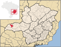
Ituiutaba
Encyclopedia
Minas Gerais
Minas Gerais is one of the 26 states of Brazil, of which it is the second most populous, the third richest, and the fourth largest in area. Minas Gerais is the Brazilian state with the largest number of Presidents of Brazil, the current one, Dilma Rousseff, being one of them. The capital is the...
state, Brazil
Brazil
Brazil , officially the Federative Republic of Brazil , is the largest country in South America. It is the world's fifth largest country, both by geographical area and by population with over 192 million people...
. Elevated to city status in 1901, it had a population in 2007 of 100,316 and a total area in the municipality of 2,694 km². The elevation of the seat of the municipality is 544 mts..
Location
It is located in the west of the economic and geographical region called Triângulo MineiroTriângulo Mineiro
The Triangle Mineiro Portuguese pronunciation: [tɾiɐɡulu minejru] is an officer in the region west of the state of Minas Gerais, Brazil. The area is 93.500 km ² and is limited by the Serra da Canastra and Marcela, east, south of Sao Paulo, Goias in the north and west of the junction of the rivers...
and is on BR 365, which begins at Chaveslândia in the west and connects as far as Pirapora
Pirapora
Pirapora is a municipality in northcentral Minas Gerais in Brazil. Its population in 2007 was 51,636 in a total area of 577 km². The name Pirapora comes from the Tupi words for "fish" + "jump", referring to the piracema season when a mass migration of fishes ascends the São Francisco River...
in the north. Neighboring municipalties are Gurinhatã
Gurinhatã
Gurinhatã is a municipality in the west of the Brazilian state of Minas Gerais. As of 2007 the population was 6,194 in a total area of 1,844 km². It became a municipality in 1962.-Location:...
, Ipiaçú
Ipiaçu
Ipiaçu is a municipality in the west of the Brazilian state of Minas Gerais. As of 2007 the population was 4,191 in a total area of 470 km². It became a municipality in 1962.-Location:...
, Capinópolis
Capinópolis
Capinópolis is a municipality in the west of the Brazilian state of Minas Gerais. As of 2007 the population was 15,302 in a total area of 621 km². It became a municipality in 1953. The name means "city of grass".-Location:...
, Canápolis
Canápolis
Canápolis is a Brazilian municipality located in the west of the state of Minas Gerais. Its population as of 2007 was 11,313 living in a total area of 845 km². The city belongs to the statistical mesoregion of Triângulo Mineiro and Alto Paranaíba and to the statistical microregion of Uberlândia. ...
, Santa Vitória
Santa Vitória, Minas Gerais
Santa Vitória is a municipality in the west of the Brazilian state of Minas Gerais. , the population was 18,157. It became a municipality in 1948....
, Monte Alegre de Minas
Monte Alegre de Minas
Monte Alegre de Minas is a Brazilian municipality located in the west of the state of Minas Gerais. Its population as of 2007 was 18,348 living in a total area of 2,593 km². The city belongs to the statistical mesoregion of Triângulo Mineiro and Alto Paranaíba and to the statistical microregion of...
, Prata, Campina Verde
Campina Verde
Campina Verde is a municipality in the north of the Brazilian state of Minas Gerais. As of 2007 the population was 18,680 in a total area of 3,663 km². It became a municipality in 1938.-Location:...
and the state of Goiás
Goiás
Goiás is a state of Brazil, located in the central part of the country. The name Goiás comes from the name of an indigenous community...
.
Distances
- UberlândiaUberlândiaUberlândia is the main town in the Triangle region, west of the state of Minas Gerais, Brazil. With a population of 604,013 inhabitants, according to 2010 estimates, the city is the second largest in the state second only to Belo Horizonte...
: 135 km - UberabaUberabaUberaba is a city and municipality in the west of the state of Minas Gerais in Brazil. Its population is 296.000 with an area of 4529.7 km², giving a density of 60.71 people per km². It is located on a plateau at an elevation of 785 meters and is in the Uberaba River floodplain...
: 237 km - ItumbiaraItumbiaraItumbiara is a small city and municipality in the extreme south of the state of Goiás, Brazil. The population was 100,000 in a total area of 2,461,3 km²...
: 110 km - Chaveslândia: 135 km
- Belo HorizonteBelo HorizonteBelo Horizonte is the capital of and largest city in the state of Minas Gerais, located in the southeastern region of Brazil. It is the third largest metropolitan area in the country...
: 685 km
Statistical Microregion
Ituiutaba is also the name of statistical microregion 29 which includes 06 municipalities: Cachoeira DouradaCachoeira Dourada, Minas Gerais
Cachoeira Dourada is a municipality in the west of the Brazilian state of Minas Gerais. As of 2007 the population was 2,470 in a total area of 202 km²...
, Capinópolis
Capinópolis
Capinópolis is a municipality in the west of the Brazilian state of Minas Gerais. As of 2007 the population was 15,302 in a total area of 621 km². It became a municipality in 1953. The name means "city of grass".-Location:...
, Gurinhatã
Gurinhatã
Gurinhatã is a municipality in the west of the Brazilian state of Minas Gerais. As of 2007 the population was 6,194 in a total area of 1,844 km². It became a municipality in 1962.-Location:...
, Ipiaçu
Ipiaçu
Ipiaçu is a municipality in the west of the Brazilian state of Minas Gerais. As of 2007 the population was 4,191 in a total area of 470 km². It became a municipality in 1962.-Location:...
, Ituiutaba, and Santa Vitória
Santa Vitória, Minas Gerais
Santa Vitória is a municipality in the west of the Brazilian state of Minas Gerais. , the population was 18,157. It became a municipality in 1948....
. The population of this microregion was 135,140 (2000) and the area was 8,748.90 km². The population density in 2000 was 15.45 inhab/km².
Climate
Classified as AW hot-humid (according to the Koppen classification), tropical with dry winter, with a well-defined rainy season from October to April and a dry season from May to September. Average temperatures range from 14°C in June to 31°C in December. The yearly average is 28°C. Frost is rare.Economic activities
The most important economic activities are cattle raising, industry, commerce, and agriculture. The GDP in 2005 was R$ 972,529,000. Ituiutaba is in the top tier of municipalities in the state with regard to economic and social development. It is the center of a rich agricultural area which receives adequate rainfall and is well watered. As of 2007 there were 08 banking agencies in the town. There were 14,365 automobiles.In the rural area there were 1,459 establishments occupying about 4,300 workers. 628 of the farms had tractors, a ratio of around one tractor for every two farms. There were 190,000 head of cattle in 2006. The crops with a planted area of more than 1000 hectares were sugarcane, corn and soybeans. There was also production of rubber, coffee, and oranges.
Health and education
Ituiutaba has high quality of life, using Brazilian standards. The population is comparatively well-educated. According to the city government site (no date given) there were 128 doctors, 130 dentists, 13 veterinarians, 18 psychologists, 170 lawyers, 14 architects, and 111 agronomists.In the health sector there were 54 total establishments, 23 public and 31 private. Of these there were 06 hospitals with 211 beds. In the educational sector there were 33 pre-schools, 39 primary schools and 05 middle schools. There were 03 institutes of higher education, all private.
- Municipal Human Development IndexHuman Development IndexThe Human Development Index is a composite statistic used to rank countries by level of "human development" and separate "very high human development", "high human development", "medium human development", and "low human development" countries...
: 0.818 (2000) - State ranking: 15 out of 853 municipalities as of 2000
- National ranking: 254 out of 5,138 municipalities as of 2000
The highest ranking municipality in Minas Gerais in 2000 was Poços de Caldas
Poços de Caldas
Poços de Caldas is a city and municipality in south-western Minas Gerais state, Brazil, in the microregion of the same name. Its estimated population in 2009 was 151,449 inhabitants...
with 0.841, while the lowest was Setubinha
Setubinha
Setubinha is a municipality in the northeast of the Brazilian state of Minas Gerais. As of 2007 the population was 10,834 in a total area of 536 km². The elevation is 729 metres. It is part of the IBGE statistical microregion of Teófilo Otoni...
with 0.568. Nationally the highest was São Caetano do Sul
São Caetano do Sul
São Caetano do Sul is a city in São Paulo state in Brazil, located in the Greater São Paulo Metropolitan Area. It is the city with the highest per capita income in Brazil and it also has the highest Human Development Index .-Geography:São Caetano do Sul is located on a plateau that is part of the...
in São Paulo with 0.919, while the lowest was Setubinha. In more recent statistics (considering 5,507 municipalities) Manari in the state of Pernambuco
Pernambuco
Pernambuco is a state of Brazil, located in the Northeast region of the country. To the north are the states of Paraíba and Ceará, to the west is Piauí, to the south are Alagoas and Bahia, and to the east is the Atlantic Ocean. There are about of beaches, some of the most beautiful in the...
has the lowest rating in the country—0,467—putting it in last place.
- Literacy rate: 89%
- Life expectancy: 76.0 (average of males and females)
- Urbanization rate: 51.36%
- Percentage of urban houses connected to sewage system: 99
Media
There are five television stations: Rede Integração - affiliated with Rede Globo, Rede Vitoriosa - affiliated with Sistema Brasileiro de Televisão - SBT, TV Paranaiba - affiliated with Rede Record, Band Triângulo - affiliated with Band and Rede Vida. There are seven radio stations: Rádio Cancella FM, Rádio Cancella AM, Rádio Difusora FM, Rádio Difusora AM, Rádio Interativa FM, Rádio Globo AM and Rádio Dimensão FM. There are three newspapers: Jornal do Pontal, Gazeta do Pontal and Jornal Hoje em Dia.History
The settlement of the region began in 1820 when Joaquim Antonio de Morais and José da Silva Ramos arrived and expelled the native inhabitants, the Caiapós. The first name was Arraial de São José do Tijuco. In 1890 there were 5,000 inhabitants. In 1901 it became a municipality with the name Vila Platina, later changed in 1917 to Ituiutaba.See also
- List of municipalities in Minas Gerais