

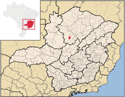
Pirapora
Encyclopedia
Minas Gerais
Minas Gerais is one of the 26 states of Brazil, of which it is the second most populous, the third richest, and the fourth largest in area. Minas Gerais is the Brazilian state with the largest number of Presidents of Brazil, the current one, Dilma Rousseff, being one of them. The capital is the...
in Brazil
Brazil
Brazil , officially the Federative Republic of Brazil , is the largest country in South America. It is the world's fifth largest country, both by geographical area and by population with over 192 million people...
. Its population in 2007 was 51,636 in a total area of 577 km². The name Pirapora comes from the Tupi words for "fish" + "jump", referring to the piracema
Piracema
Piracema is the name given to the period of the year when fish within the Paraguay River drainage basin―which includes the Pantanal region in the Brazilian states of Mato Grosso and Mato Grosso do Sul―reproduce....
season when a mass migration of fishes ascends the São Francisco River
São Francisco River
The São Francisco is a river in Brazil. With a length of , it is the longest river that runs entirely in Brazilian territory, and the fourth longest in South America and overall in Brazil...
to spawn
Location
Pirapora belongs to its own statistical microregion. The elevation of the municipal seat is 472 meters. It became a municipality in 1912. This municipality is located on the right bank of the São Francisco RiverSão Francisco River
The São Francisco is a river in Brazil. With a length of , it is the longest river that runs entirely in Brazilian territory, and the fourth longest in South America and overall in Brazil...
and is 340 km. from the state capital.
Neighboring municipalities are: Lagoa Grande
Lagoa Grande, Minas Gerais
Lagoa Grande is a municipality in the northeast of the Brazilian state of Minas Gerais. Its population in 2007 was 8,660 inhabitants in a total area of 1,220 km²....
, Coromandel
Coromandel, Minas Gerais
Coromandel is a Brazilian town, located in the southeast region of the country, in the state of Minas Gerais. Its population is over 28,000 people according the 2004 census. The municipality of Coromandel is located 495 km from the state capital Belo Horizonte, and 673 km from São Paulo...
, Guarda-Mor
Guarda-Mor
Guarda-Mor is a municipality in the north of the Brazilian state of Minas Gerais. Its population in 2007 was 6,577 inhabitants in a total area of 2,066 km². It is a large producer of cattle and grains, especially soybeans....
, Lagamar
Lagamar
Lagamar is a municipality in the north of the Brazilian state of Minas Gerais. Its population in 2007 was 7,636 inhabitants in a total area of . It is a large producer of cattle and grains and there is extraction of phosphates....
and Paracatu
Paracatu, Minas Gerais
Paracatu is a town in the western part of the state of Minas Gerais, Brazil having 79,739 inhabitants . Its area is of 8.232 km²...
. There are two districts, besides the municipal seat: Claro de Minas, 12 km. distant, and Vazamor, 32 km. distant.
Microregion of Pirapora
The statistical microregion of Pirapora includes 9 cities: BuritizeiroBuritizeiro
Buritizeiro is a municipality in the north of the Brazilian state of Minas Gerais. Its population in 2007 was 26,133 inhabitants in a total area of 7,226 km². It is a major producer of cattle and grains.-Location:...
, Várzea da Palma
Várzea da Palma
Várzea da Palma is a municipality in north-central Minas Gerais in Brazil. Its population in 2007 was 54,448 in a total area of 2,195 km²....
, Ibiaí
Ibiaí
Ibiaí is a Brazilian municipality located in the north of the state of Minas Gerais. In 2007 the population was 7,571 in a total area of 870 km². It became a municipality in 1963.-Location and Distances:...
, Jequitaí
Jequitaí
Jequitaí is a Brazilian municipality located in the north of the state of Minas Gerais. In 2007 the population was 8,029 in a total area of 1,268 km². It became a municipality in 1948.-Location and Distances:...
, São Romão
São Romão
São Romão is a Brazilian municipality located in the north of the state of Minas Gerais. In 2007 the population was 9,080 in a total area of 2,432 km². It became a municipality in 1943.-Location and Distances:...
, Lassance
Lassance
Lassance is a Brazilian municipality located in the north of the state of Minas Gerais. In 2007 the population was 6,458 in a total area of 3,213 km². It became a municipality in 1953.-Location and Distances:...
, Riachinho
Riachinho
Riachinho is a Brazilian municipality located in the north of the state of Minas Gerais. In 2007 the population was 8,126 in a total area of 1,775 km². It became a municipality in 1992.-Location and Distances:...
, Santa Fé de Minas
Santa Fé de Minas
Santa Fé de Minas is a Brazilian municipality located in the north of the state of Minas Gerais. In 2007 the population was 4,034 in a total area of 2,916 km². It became a municipality in 1962....
and Lagoa dos Patos
Lagoa dos Patos, Minas Gerais
Lagoa dos Patos is a Brazilian municipality located in the north of the state of Minas Gerais. In 2007 the population was 4,448 in a total area of 599 km². It became a municipality in 1962....
. It has an area of 23,111 km2 and a population of approximately 150,000 inhabitants.
History
The city is located on the right bank of the great São Francisco RiverSão Francisco River
The São Francisco is a river in Brazil. With a length of , it is the longest river that runs entirely in Brazilian territory, and the fourth longest in South America and overall in Brazil...
, the longest river to flow entirely inside Brazilian territory. Its history goes back to the colonial period of the bandeirantes and the gold panhandlers who folloed the river upstream and arrived at the rapids of Pirapora and founded the settlement of São Gonçalo das Tabocas. In 1911 the small Arraial de São Gonçalo de Pirapora became the seat of a municipality and its name was shortened to Pirapora. Its street plan was laid out in the form of a chess set, inspired by the new capital of Belo Horizonte, and the streets were given names of Brazilian states.
There are highway connections with the main federal highway, the BR 040, to the west. In 1910 the railroad came up from the south and reached Pirapora, with a bridge (694 m) being built across the river. There were plans to extend the line to the coast. At the end of the nineteen seventies the line was deactivated, but the bridge and the rails still remain.
Today the river has lost its economic importance and is mainly used by tourist boats that attempt to recreate the spirit of the past, when Mississippi style riverboats were used to go as far as Juazeiro in Bahia. These boats used charcoal, which contributed to the disappearance of the vegetation along the river. One of the old paddle wheel steamboats, the Benjamim Guimarães
Benjamim Guimarães
The Benjamim Guimarães is a steam paddle boat based in Pirapora, Minas Gerais, Brazil.It was built at Pittsburgh in the United States by James Rees and Company in 1913, one of a number of similar steamboats built for South American service. It originally navigated the rivers of the Amazon basin...
, can still be seen anchored in front of the city and is a major tourist site.
The economy
The main economic activities are industry, cattle raising, farming (both extensive mechanized and subsistence), goods and services, and tourism. The GDP for 2005 was R$662,985,000. In the rural area there were 605 farms and a total agricultural area of 57,000 hectares, of which 38,000 ha. were planted, 14,000 were in natural pasture, and 13,000 ha. were in woodland or forest. 2,800 people were dependent on farming. 107 of the farms had tractors. In 2006 there were 9,600 head of cattle. With irrigation Pirapora has become a major producer of tropical fruits, growing eating grapes, papaya, mangoes, cantaloupe, and guava. There is also production on a smaller scale of corn, beans, rice, manioc, tomatoes, lettuce, and bananas.According to the city government site, Pirapora is the second most important city in the north of Minas, after Montes Claros, in industrial output. There is an industrial park where several small and medium industries are installed. Iron silicon, metallic silicon, and textiles are produced.
Health and education
In 2005 there were 39 health establishments—25 public and 14 private. There was 01 public hospital and 02 private hospitals. The number of hospital beds was 133. The Centro Regional de Saúde da Visão is a public clinic that specializes in eye surgery and attracts patients from all over the north of Minas Gerais.In 2007 there were three institutes of higher learning in the city: Instituto Educacional Santo Agostinho (private), União de Ensino de Minas Gerais Ltda (private), and UNIMONTES-Universidade Estadual de Montes Claros (public).
The score on the Municipal Human Development Index
Human Development Index
The Human Development Index is a composite statistic used to rank countries by level of "human development" and separate "very high human development", "high human development", "medium human development", and "low human development" countries...
was 0.758. Pirapora was ranked 235 out of 853 municipalities in the state, with Poços de Caldas
Poços de Caldas
Poços de Caldas is a city and municipality in south-western Minas Gerais state, Brazil, in the microregion of the same name. Its estimated population in 2009 was 151,449 inhabitants...
in first place with 0.841 and Setubinha
Setubinha
Setubinha is a municipality in the northeast of the Brazilian state of Minas Gerais. As of 2007 the population was 10,834 in a total area of 536 km². The elevation is 729 metres. It is part of the IBGE statistical microregion of Teófilo Otoni...
in last place with 0.568.