
Maryland Route 58
Encyclopedia
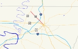
Maryland Route 58 is a state highway
in the U.S. state
of Maryland
. Known for most of its length as Cearfoss Pike, the state highway runs 3.53 miles (5.7 km) from MD 63
in Cearfoss
east to Key Circle in Hagerstown
. MD 58 was constructed in the late 1920s along what was originally the Hagerstown and Cross Roads Turnpike.
. The roundabout
is 0.03 mile (0.0482802 km) north of MD 63's intersection with MD 494
(Fairview Road). MD 58 heads southeast as two-lane Cearfoss Pike through farmland and scattered residences. Between Point Salem Road and Terps Boulevard, MD 58 expands to a four-lane divided highway and meets I-81
(Maryland Veterans Memorial Highway) at a partial cloverleaf interchange. Within the interchange, the state highway enters the city of Hagerstown and its name changes to Salem Avenue. East of I-81, MD 58 enters a densely-populated residential area, reduces to a two-lane street, and reaches its eastern terminus at the intersection with Key Circle. Salem Avenue continues southeast as a municipal street toward downtown Hagerstown.
.
{|class=wikitable
!Location
!Mile
!Destinations
!Notes
|-
|Cearfoss
|0.00
|
|Western terminus; Cearfoss Roundabout
|-
|rowspan=2|Hagerstown
|3.19
|
|I-81 Exit 7
|-
|3.53
|Salem Avenue east / Key Circle south
|Eastern terminus
State highway
State highway, state road or state route can refer to one of three related concepts, two of them related to a state or provincial government in a country that is divided into states or provinces :#A...
in the U.S. state
U.S. state
A U.S. state is any one of the 50 federated states of the United States of America that share sovereignty with the federal government. Because of this shared sovereignty, an American is a citizen both of the federal entity and of his or her state of domicile. Four states use the official title of...
of Maryland
Maryland
Maryland is a U.S. state located in the Mid Atlantic region of the United States, bordering Virginia, West Virginia, and the District of Columbia to its south and west; Pennsylvania to its north; and Delaware to its east...
. Known for most of its length as Cearfoss Pike, the state highway runs 3.53 miles (5.7 km) from MD 63
Maryland Route 63
Maryland Route 63 is a state highway in the U.S. state of Maryland. The state highway runs from MD 65 in Fairplay north to the Pennsylvania state line near Cearfoss, where the highway continues as Pennsylvania Route 163 . MD 63 is an L-shaped route that passes through central Washington County...
in Cearfoss
Cearfoss, Maryland
Cearfoss is an unincorporated community in northwestern Washington County, Maryland, United States. It is located northwest of Hagerstown and Maugansville near the Pennsylvania border. Many highways intersect in Cearfoss in a roundabout including Maryland Route 63, Maryland Route 58, and Maryland...
east to Key Circle in Hagerstown
Hagerstown, Maryland
Hagerstown is a city in northwestern Maryland, United States. It is the county seat of Washington County, and, by many definitions, the largest city in a region known as Western Maryland. The population of Hagerstown city proper at the 2010 census was 39,662, and the population of the...
. MD 58 was constructed in the late 1920s along what was originally the Hagerstown and Cross Roads Turnpike.
Route description
MD 58 begins at the Cearfoss Roundabout in Cearfoss, where the highway intersects MD 63 (Greencastle Pike) and the county-maintained portion of Cearfoss Pike, which heads northwest toward Mercersburg, PennsylvaniaMercersburg, Pennsylvania
Mercersburg is a borough in Franklin County, Pennsylvania, southwest of Harrisburg. Originally called Black Town, it was incorporated in 1831. In 1900, 956 people lived here, and in 1910, 1,410 people lived here...
. The roundabout
Roundabout
A roundabout is the name for a road junction in which traffic moves in one direction around a central island. The word dates from the early 20th century. Roundabouts are common in many countries around the world...
is 0.03 mile (0.0482802 km) north of MD 63's intersection with MD 494
Maryland Route 494
Maryland Route 494 is a state highway in the U.S. state of Maryland. Known as Fairview Road, the state highway runs from the Pennsylvania state line near Fairview, where the highway continues north as Pennsylvania Route 75 , east to MD 63 in Cearfoss. MD 494 was constructed in the 1930s...
(Fairview Road). MD 58 heads southeast as two-lane Cearfoss Pike through farmland and scattered residences. Between Point Salem Road and Terps Boulevard, MD 58 expands to a four-lane divided highway and meets I-81
Interstate 81 in Maryland
Interstate 81 is a part of the Interstate Highway System that runs from Dandridge, Tennessee to Fishers Landing, New York. In Maryland, the Interstate highway runs from the West Virginia state line at the Potomac River in Williamsport north to the Pennsylvania state line near Maugansville...
(Maryland Veterans Memorial Highway) at a partial cloverleaf interchange. Within the interchange, the state highway enters the city of Hagerstown and its name changes to Salem Avenue. East of I-81, MD 58 enters a densely-populated residential area, reduces to a two-lane street, and reaches its eastern terminus at the intersection with Key Circle. Salem Avenue continues southeast as a municipal street toward downtown Hagerstown.
History
The predecessor highway of MD 58 was the 19th century Hagerstown and Cross Roads Turnpike, which followed essentially the same alignment as modern MD 58 between the tollgate at Broadfording Road, now just east of I-81, and Cearfoss. What is now the county-maintained portion of Cearfoss Pike was originally the Mercersburg Road. About 1 miles (1.6 km) of that county highway from Cearfoss to Conococheague Creek was paved as a state-aid road in 1916 but was not taken into the state road system and was never part of MD 58. MD 58 was paved from Broadfording Road to Garden View Road in 1928 and extended to Cearfoss in 1930. The state highway was rebuilt starting in 1956; the highway was expanded at that time to a four-lane divided highway around its interchange with I-81, which was completed in 1958. The Cearfoss Roundabout at the state highway's western terminus was constructed in 1995.Junction list
The entire route is in Washington CountyWashington County, Maryland
Washington County is a county located in the western part of the U.S. state of Maryland, bordering southern Pennsylvania to the north, northern Virginia to the south, and the Eastern Panhandle of West Virginia to the south and west. As of the 2010 Census, its population is 147,430...
.
{|class=wikitable
!Location
!Mile
!Destinations
!Notes
|-
|Cearfoss
Cearfoss, Maryland
Cearfoss is an unincorporated community in northwestern Washington County, Maryland, United States. It is located northwest of Hagerstown and Maugansville near the Pennsylvania border. Many highways intersect in Cearfoss in a roundabout including Maryland Route 63, Maryland Route 58, and Maryland...
|0.00
|
|Western terminus; Cearfoss Roundabout
Roundabout
A roundabout is the name for a road junction in which traffic moves in one direction around a central island. The word dates from the early 20th century. Roundabouts are common in many countries around the world...
|-
|rowspan=2|Hagerstown
Hagerstown, Maryland
Hagerstown is a city in northwestern Maryland, United States. It is the county seat of Washington County, and, by many definitions, the largest city in a region known as Western Maryland. The population of Hagerstown city proper at the 2010 census was 39,662, and the population of the...
|3.19
|
|I-81 Exit 7
|-
|3.53
|Salem Avenue east / Key Circle south
|Eastern terminus