
.gif)
Interstate 295 (District of Columbia)
Encyclopedia
Interstate 295 in the U.S. state
of Maryland
and in Washington, D.C.
is a 8.05 miles (13 km) spur route connecting I-95/I-495
and Maryland Route 210
(Indian Head Highway) on the Potomac River
(just outside the District's boundary with Maryland) to Interstate 695
in downtown Washington.
 Although I-295 technically begins at the Capital Beltway (I-95
/I-495), a pair of mainline ramps connects the southern terminus of the route to the nearby MD 210
. Continuing north from this interchange, I-295 enters the District of Columbia; the route is only 0.8 miles (1.3 km) long in Maryland. The highway is known throughout as the Anacostia Freeway.
Passing to the west and north of Oxon Cove Park
, the route parallels the Potomac River
, running through the Southeast quadrant of D.C. It passes close to Shepard Parkway and forms the eastern boundary of Bolling Air Force Base
and the Anacostia Naval Station. Near the southern end of Anacostia Park
the route turns east and begins to parallel the Anacostia River
, interchanging with South Capitol Street near the latter's crossing of the river.
Within the park, I-295 encounters the southern end of the 11th Street Bridges
and exits from itself onto the bridges; the mainline freeway through the interchange assumes the identity of D.C. Route 295. The route continues to Baltimore, though it changes identities several times: I-295, DC 295, MD 201
, the Baltimore-Washington Parkway
(an unnumbered federally owned expressway
operated by the National Park Service
), and MD 295.
I-295 the crosses the Anacostia River
and interchanges with I-695
, an unfinished connector highway known as the Southeast Freeway. Officially I-295 comes to an end at the Southeast Freeway.
According to signage, I-295 continues along the Southeast Freeway to end at I-395 (I-295 is shown to do this in some road atlases).
in 1950 as a connector route between the Baltimore-Washington Parkway
at Kenilworth Avenue and the Capital Beltway
near Oxon Hill
. The route would provide access to the Anacostia waterfront, which included Bolling Air Force Base
and the Anacostia Naval Station. In 1955, District officials approved the portion of the route between Suitland Parkway and E Capitol Street; the remainder of the route was approved in 1956. The southern portion of the route, from the Beltway to the 11th Street Bridges, was given a financial boost when it was included in the Interstate Highway System
. The route was designated I-295 by AASHO in 1958.
The first 7.8 miles (12.6 km) of the route opened on August 7, 1964 when the connecting segment of the Capital Beltway
opened. In 1990, the freeway was extended 1.7 miles (2.7 km) south to connect with MD 210
, to remove the significant traffic flow between the two routes from the segment of the Beltway between both interchanges.
and followed the Southeast Freeway as far as East Capitol Street
, where it would turn north and follow the East Leg of the Inner Loop
freeway. The East Leg, six lanes wide, would have curved around the far eastern edge of the downtown area, passing beneath Mt. Olivet Road in a 1/2 mile tunnel, before terminating at I-66 and I-95 north of Union Station
, providing access to the North Leg Freeway, the North Central Freeway, and the New York Avenue Industrial Freeway.
in Prince George's County, Maryland
. The interchange has been rebuilt to accommodate future ramps for proposed HOV lanes on the Beltway. The project was completed in stages starting in 2008 and ending in 2011.
U.S. state
A U.S. state is any one of the 50 federated states of the United States of America that share sovereignty with the federal government. Because of this shared sovereignty, an American is a citizen both of the federal entity and of his or her state of domicile. Four states use the official title of...
of Maryland
Maryland
Maryland is a U.S. state located in the Mid Atlantic region of the United States, bordering Virginia, West Virginia, and the District of Columbia to its south and west; Pennsylvania to its north; and Delaware to its east...
and in Washington, D.C.
Washington, D.C.
Washington, D.C., formally the District of Columbia and commonly referred to as Washington, "the District", or simply D.C., is the capital of the United States. On July 16, 1790, the United States Congress approved the creation of a permanent national capital as permitted by the U.S. Constitution....
is a 8.05 miles (13 km) spur route connecting I-95/I-495
Interstate 495 (Capital Beltway)
Interstate 495 is a Interstate Highway that surrounds the United States' capital of Washington, D.C., and its inner suburbs in adjacent Maryland and Virginia. I-495 is widely known as the Capital Beltway or simply the Beltway, especially when the context of Washington, D.C., is clear...
and Maryland Route 210
Maryland Route 210
Maryland Route 210 , or Indian Head Highway, is a state highway in Prince George's and Charles counties in Maryland. At its northern end, MD 210 starts from the end of South Capitol Street in Washington, D.C., connecting the U.S. Capitol with Indian Head, Maryland...
(Indian Head Highway) on the Potomac River
Potomac River
The Potomac River flows into the Chesapeake Bay, located along the mid-Atlantic coast of the United States. The river is approximately long, with a drainage area of about 14,700 square miles...
(just outside the District's boundary with Maryland) to Interstate 695
Interstate 695 (District of Columbia)
Interstate 695 is the unsigned designation for the 1.39-mile Southeast Freeway in Washington, D.C. It runs from Interstate 395 south of the United States Capitol building east past the north end of Interstate 295 to Pennsylvania Avenue at Barney Circle, just northwest of the John Philip Sousa...
in downtown Washington.
Route description
Interstate 95 in Maryland
Interstate 95 in Maryland is a major highway that runs diagonally from northeast to southwest, from Maryland's border with Delaware, to the Woodrow Wilson Bridge, briefly entering the District of Columbia before reaching Virginia...
/I-495), a pair of mainline ramps connects the southern terminus of the route to the nearby MD 210
Maryland Route 210
Maryland Route 210 , or Indian Head Highway, is a state highway in Prince George's and Charles counties in Maryland. At its northern end, MD 210 starts from the end of South Capitol Street in Washington, D.C., connecting the U.S. Capitol with Indian Head, Maryland...
. Continuing north from this interchange, I-295 enters the District of Columbia; the route is only 0.8 miles (1.3 km) long in Maryland. The highway is known throughout as the Anacostia Freeway.
Passing to the west and north of Oxon Cove Park
Oxon Cove Park and Oxon Hill Farm
Oxon Cove Park and Oxon Cove Farm is a national historic district that includes a living farm museum operated by the National Park Service, and located at Oxon Hill, Prince George's County, Maryland...
, the route parallels the Potomac River
Potomac River
The Potomac River flows into the Chesapeake Bay, located along the mid-Atlantic coast of the United States. The river is approximately long, with a drainage area of about 14,700 square miles...
, running through the Southeast quadrant of D.C. It passes close to Shepard Parkway and forms the eastern boundary of Bolling Air Force Base
Bolling Air Force Base
Joint Base Anacostia-Bolling is a military installation, located in Southeast Washington, D.C., established on 1 October 2010 in accordance with congressional legislation implementing the recommendations of the 2005 Base Realignment and Closure Commission...
and the Anacostia Naval Station. Near the southern end of Anacostia Park
Anacostia Park
Anacostia Park is operated by the United States National Park Service. It is one of Washington, D.C.'s largest and most important recreation areas, with over 1200 acres at multiple sites. Included in Anacostia Park is Kenilworth Park and Aquatic Gardens and Kenilworth Marsh...
the route turns east and begins to parallel the Anacostia River
Anacostia River
The Anacostia River is a river in the Mid Atlantic region of the United States. It flows from Prince George's County in Maryland into Washington, D.C., where it joins with the Washington Channel to empty into the Potomac River at Buzzard Point. It is approximately long...
, interchanging with South Capitol Street near the latter's crossing of the river.
Within the park, I-295 encounters the southern end of the 11th Street Bridges
11th Street Bridges
The 11th Street Bridges are a pair of one-way bridges across the Anacostia River in Washington, D.C., U.S.A. The southbound structure is officially named the Officer Kevin J. Welsh Memorial Bridge, while the northbound structure is officially named the 11th Street Bridge. The bridges convey...
and exits from itself onto the bridges; the mainline freeway through the interchange assumes the identity of D.C. Route 295. The route continues to Baltimore, though it changes identities several times: I-295, DC 295, MD 201
Maryland Route 201
-Route description:MD 201 begins at a large hybrid cloverleaf just outside the D.C. boundary at Tuxedo, Maryland that is maintained by the Maryland State Highway Administration...
, the Baltimore-Washington Parkway
Baltimore-Washington Parkway
The Baltimore–Washington Parkway is a highway in the U.S. state of Maryland, running southwest from Baltimore to Washington, D.C. The road begins at an interchange with U.S. Route 50 and Maryland Route 201 near Cheverly in Prince George's County at the D.C...
(an unnumbered federally owned expressway
Controlled-access highway
A controlled-access highway is a highway designed exclusively for high-speed vehicular traffic, with all traffic flow and ingress/egress regulated...
operated by the National Park Service
National Park Service
The National Park Service is the U.S. federal agency that manages all national parks, many national monuments, and other conservation and historical properties with various title designations...
), and MD 295.
I-295 the crosses the Anacostia River
Anacostia River
The Anacostia River is a river in the Mid Atlantic region of the United States. It flows from Prince George's County in Maryland into Washington, D.C., where it joins with the Washington Channel to empty into the Potomac River at Buzzard Point. It is approximately long...
and interchanges with I-695
Interstate 695 (District of Columbia)
Interstate 695 is the unsigned designation for the 1.39-mile Southeast Freeway in Washington, D.C. It runs from Interstate 395 south of the United States Capitol building east past the north end of Interstate 295 to Pennsylvania Avenue at Barney Circle, just northwest of the John Philip Sousa...
, an unfinished connector highway known as the Southeast Freeway. Officially I-295 comes to an end at the Southeast Freeway.
According to signage, I-295 continues along the Southeast Freeway to end at I-395 (I-295 is shown to do this in some road atlases).
History
The Anacostia Freeway was first conceived by the National Capital Park and Planning CommissionMaryland-National Capital Park and Planning Commission
The Maryland-National Capital Park and Planning Commission is a bi-county agency that administers parks and planning in Montgomery and Prince George's Counties in Maryland.-History:...
in 1950 as a connector route between the Baltimore-Washington Parkway
Baltimore-Washington Parkway
The Baltimore–Washington Parkway is a highway in the U.S. state of Maryland, running southwest from Baltimore to Washington, D.C. The road begins at an interchange with U.S. Route 50 and Maryland Route 201 near Cheverly in Prince George's County at the D.C...
at Kenilworth Avenue and the Capital Beltway
Interstate 495 (Capital Beltway)
Interstate 495 is a Interstate Highway that surrounds the United States' capital of Washington, D.C., and its inner suburbs in adjacent Maryland and Virginia. I-495 is widely known as the Capital Beltway or simply the Beltway, especially when the context of Washington, D.C., is clear...
near Oxon Hill
Oxon Hill, Maryland
Oxon Hill is part of the Oxon Hill-Glassmanor census-designated place in southern Prince George's County, Maryland, United States. Oxon Hill is a suburb of Washington, DC located southeast of the downtown district and east of Alexandria, Virginia...
. The route would provide access to the Anacostia waterfront, which included Bolling Air Force Base
Bolling Air Force Base
Joint Base Anacostia-Bolling is a military installation, located in Southeast Washington, D.C., established on 1 October 2010 in accordance with congressional legislation implementing the recommendations of the 2005 Base Realignment and Closure Commission...
and the Anacostia Naval Station. In 1955, District officials approved the portion of the route between Suitland Parkway and E Capitol Street; the remainder of the route was approved in 1956. The southern portion of the route, from the Beltway to the 11th Street Bridges, was given a financial boost when it was included in the Interstate Highway System
Interstate Highway System
The Dwight D. Eisenhower National System of Interstate and Defense Highways, , is a network of limited-access roads including freeways, highways, and expressways forming part of the National Highway System of the United States of America...
. The route was designated I-295 by AASHO in 1958.
The first 7.8 miles (12.6 km) of the route opened on August 7, 1964 when the connecting segment of the Capital Beltway
Interstate 495 (Capital Beltway)
Interstate 495 is a Interstate Highway that surrounds the United States' capital of Washington, D.C., and its inner suburbs in adjacent Maryland and Virginia. I-495 is widely known as the Capital Beltway or simply the Beltway, especially when the context of Washington, D.C., is clear...
opened. In 1990, the freeway was extended 1.7 miles (2.7 km) south to connect with MD 210
Maryland Route 210
Maryland Route 210 , or Indian Head Highway, is a state highway in Prince George's and Charles counties in Maryland. At its northern end, MD 210 starts from the end of South Capitol Street in Washington, D.C., connecting the U.S. Capitol with Indian Head, Maryland...
, to remove the significant traffic flow between the two routes from the segment of the Beltway between both interchanges.
East Leg
Under the 1971 D.C. freeway plans, I-295 would have turned east at the northern end of the 11th Street Bridges11th Street Bridges
The 11th Street Bridges are a pair of one-way bridges across the Anacostia River in Washington, D.C., U.S.A. The southbound structure is officially named the Officer Kevin J. Welsh Memorial Bridge, while the northbound structure is officially named the 11th Street Bridge. The bridges convey...
and followed the Southeast Freeway as far as East Capitol Street
East Capitol Street
East Capitol Street is a major street that divides the northeast and southeast quadrants of Washington, D.C. It runs due east from the United States Capitol to the DC-Maryland border. The street is uninterrupted until Lincoln Park then continues eastward to Robert F. Kennedy Memorial Stadium...
, where it would turn north and follow the East Leg of the Inner Loop
Inner Loop (Washington, D.C.)
The Inner Loop was two planned freeways around downtown Washington, D.C. The innermost loop would have formed an oval centered on the White House, with a central freeway connecting the southern segment to the northern segment and then continuing on to Interstate 95. Interstate 95 would have met...
freeway. The East Leg, six lanes wide, would have curved around the far eastern edge of the downtown area, passing beneath Mt. Olivet Road in a 1/2 mile tunnel, before terminating at I-66 and I-95 north of Union Station
Union Station (Washington, D.C.)
Washington Union Station is a train station and leisure destination visited by 32 million people each year in the center of Washington, D.C. The train station is served by Amtrak, MARC and Virginia Railway Express commuter rail services as well as by Washington Metro subway trains and local buses...
, providing access to the North Leg Freeway, the North Central Freeway, and the New York Avenue Industrial Freeway.
Future
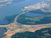
One major interchange project was recently completed and another is under construction on I-295.Woodrow Wilson Bridge project
As part of the larger Woodrow Wilson Memorial Bridge reconstruction project, the southern terminus of I-295 has been significantly rebuilt. Several new connections have been constructed to link the Beltway, MD 210 and I-295 with the new 300 acres (1.2 km²) National Harbor site, being built on the shore of the Potomac RiverPotomac River
The Potomac River flows into the Chesapeake Bay, located along the mid-Atlantic coast of the United States. The river is approximately long, with a drainage area of about 14,700 square miles...
in Prince George's County, Maryland
Prince George's County, Maryland
Prince George's County is a county located in the U.S. state of Maryland, immediately north, east, and south of Washington, DC. As of 2010, it has a population of 863,420 and is the wealthiest African-American majority county in the nation....
. The interchange has been rebuilt to accommodate future ramps for proposed HOV lanes on the Beltway. The project was completed in stages starting in 2008 and ending in 2011.
11th Street Bridges project
A major project is currently underway to significantly rebuild the interchanges among the I-295, DC 295 and the 11th Street bridges. Due to the cancellation of both the remainder of the Southeast Freeway and the newer Barney Circle Freeway, there are no through connections between the 11th Street Bridges and DC 295, leading to severe congestion and major traffic routing problems. This project is in the process of constructing the missing movements at these interchanges, allowing direct freeway-grade access to and from DC 295 at the 11th Street bridges as well as providing a through grade-separated north–south route within D.C. Project construction began in 2011.Exit list
| Location | Exit Exit number An exit number is a number assigned to a road junction, usually an exit from a freeway. It is usually marked on the same sign as the destinations of the exit, as well as a sign in the gore.... |
Destinations | Notes | |
|---|---|---|---|---|
| Prince George's County, Maryland Prince George's County, Maryland Prince George's County is a county located in the U.S. state of Maryland, immediately north, east, and south of Washington, DC. As of 2010, it has a population of 863,420 and is the wealthiest African-American majority county in the nation.... |
Continuation beyond I-95/I-495 | |||
| 1B | National Harbor Boulevard | Southbound exit and northbound entrance | ||
| 1A/C | , Richmond | Southbound exit and northbound entrance; signed as exits 1A (north) and 1C (south) | ||
| Washington, D.C. Washington, D.C. Washington, D.C., formally the District of Columbia and commonly referred to as Washington, "the District", or simply D.C., is the capital of the United States. On July 16, 1790, the United States Congress approved the creation of a permanent national capital as permitted by the U.S. Constitution.... |
1 | Laboratory Road– U.S. Naval Research Lab | ||
| 2 | Malcolm X Avenue – Bolling AFB | |||
| 3A | Suitland Parkway Suitland Parkway The Suitland Parkway is a parkway in Washington, D.C., and Prince George's County, Maryland, maintained by the U.S. National Park Service. Conceived in 1937, it was built during World War II to provide a road connection between military facilities in the Washington, D.C., metropolitan area, and... – Anacostia Naval Station |
No southbound entrance | ||
| 3B | South Capitol Street South Capitol Street South Capitol Street is a major street dividing the southeast and southwest quadrants of Washington, D.C. It runs south from the United States Capitol to the Washington-Maryland line... , Howard Road – Downtown Washington Downtown Washington, D.C. Downtown is a neighborhood of Washington, D.C., as well as a colloquial name for the central business district in the northwest quadrant of the city. Geographically, the area extends roughly five to six blocks west, northwest, north, northeast, and east of the White House... |
signed as South Capitol Street northbound, Howard Road southbound | ||
| Northbound exit and southbound entrance | ||||
| Martin Luther King, Jr. Avenue – Anacostia Park Anacostia Park Anacostia Park is operated by the United States National Park Service. It is one of Washington, D.C.'s largest and most important recreation areas, with over 1200 acres at multiple sites. Included in Anacostia Park is Kenilworth Park and Aquatic Gardens and Kenilworth Marsh... |
Southbound exit and northbound entrance | |||
| 11th Street Bridges 11th Street Bridges The 11th Street Bridges are a pair of one-way bridges across the Anacostia River in Washington, D.C., U.S.A. The southbound structure is officially named the Officer Kevin J. Welsh Memorial Bridge, while the northbound structure is officially named the 11th Street Bridge. The bridges convey... over the Anacostia River Anacostia River The Anacostia River is a river in the Mid Atlantic region of the United States. It flows from Prince George's County in Maryland into Washington, D.C., where it joins with the Washington Channel to empty into the Potomac River at Buzzard Point. It is approximately long... |
||||
| M Street – Washington Navy Yard Washington Navy Yard The Washington Navy Yard is the former shipyard and ordnance plant of the United States Navy in Southeast Washington, D.C. It is the oldest shore establishment of the U.S. Navy... |
Northbound exit and southbound entrance | |||
| RFK Stadium | Northbound exit and southbound entrance; closed except for stadium games | |||
| 8th Street Southeast | Northbound exit and southbound entrance | |||
| Northbound exit and southbound entrance | ||||