

Integrated urban water management in Buenos Aires, Argentina
Encyclopedia
Integrated urban water management
(IUWM) in Buenos Aires
is not unlike many large urban areas in Latin America where in past decades, more focus was placed on just a few sectors or only one sector. The water management philosophy in Buenos Aires has evolved to one that is integrating efforts in reducing water pollution, improving stormwater
management, adding drainage
infrastructure, and controlling water supply. Primary challenges in urban water management will continue to be flood control and stormwater management as Buenos Aires is situated in a low-lying pampas region where heavy rain can be expected all year long. Adding to the challenges, urbanization has outpaced planning and development in the various water sectors. Efforts have been made to control the major tributaries of Río de la Plata
such as channelizing and building culverts into urban rivers, however, this has increased flooding as the natural meander and saturating ability of the rivers have been lost. Rapid urbanization and very large quantities of industrial discharge have also caused severe contamination of the water basins that Buenos Aires is built upon. The Matanza-Riachuelo river (MR)
, a tributary of the Río de la Plata (La Plata River), is a prime example and has become the most contaminated basin in Argentina
.
In response to water pollution and flooding challenges, the Government of Argentina (GoA) is working with the World Bank
to address industrial water pollution by providing technical assistance and mentoring to the 50 worst industrial polluters which represent 95% of the total effluent. Oversight and monitoring is provided by the Matanza-Riachuelo River Basin Authority (ACUMAR). The Urban Flood Prevention and Drainage Program (APL) is the government's commitment to flood prevention and risk management and falls within the framework of the Buenos Aires Hydraulic Master Plan. The "Master Plan' focuses on implementing non-structural measures throughout the entire city.
Recent history in Buenos Aires urban water management is notable for its move to privatization
of the water and sanitation systems.
Signed in 1992, the Buenos Aires water concession was a unique example of water privatization on a large urban scale for its rapid implementation. The concession handed control of water and sanitation
systems to the French company Suez S.A.. Generating controversy for its size, the privatization was successful in that improvements were made to water and service coverage while efficiencies were gained within the water company itself. Additionally, a near 27% reduction in water tariffs quickly followed after the signing of the concession. After a renegotiation of terms in 1997 that generated wide criticism, the concession was canceled in 2006. Water and sewer provisions in the Buenos Aires Metro Area (BAMA) have since been handled by a conglomerate of companies called Water of Greater Buenos Aires (Aguas del Gran Buenos Aires).
primary fiscal surpluses, has helped to sustain this strong performance. Consequently, average real GDP
increased by nearly 9% per year between 2003 and 2006, surpassing the maximum GDP reached in 1998. Poverty and unemployment
have fallen substantially from their peaks during the economic crisis. Poverty has declined to about 31% from a high of over 57% in 2002, while unemployment fell to near 11% from 21% in 2003.
The period in Argentina between 1990 and 1993 was a time of transition away from social policies, government support devices, and welfare systems to an IMF-backed structural adjustment in economic and market policies. During this time, crime became a serious problem with the creation of an informal criminal economy that sought to take advantage of a lack of economic authority. Crime rates rose 286% between 1992 and 1995 and in 1995 the former President, Carlos Menem
was re-elected with international praise for achieving low inflation, privatizing state-run companies and the currency peg to the dollar. Crime has continued to grow as a considerable social concern in the aftermath of the 2001 recession and a reversal of the currency peg where hyperinflation
ensued. Consequently, the arms and drug trade has flourished and slums in Buneos Aires grew by 114% during the 1990s to around 113,000 people. These slums lack basic public services and law enforcement, and have become safe havens for criminal activities.
of Argentina and is bordered on the eastern and north-east sides by the Río de la Plata
, on the south and southeast side by the Riachuelo
and to the northwest, west and Southwest by the Avenida General Paz, which is a long highway that separates the Buenos Aires Province
from the city.
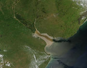
The region was formerly transected by small tributaries and some lagoons, some of which were refilled and others piped. Among the most important small tributary basins are the Maldonado, Vega, Medrano, Cildañez and White. In 1908 many of these tributaries were channelized as floods were damaging the city's infrastructure. Starting in 1919, most creeks were enclosed. Notably, the Maldonado was re-engineered in 1954 to flow underground in tubes and currently runs below Juan B. Justo Avenue.
The city has a humid subtropical climate
and the average annual temperature is 17.6 °C (63.7 °F). The city gets 1147 mm (45 in) of rainfall per year. Rain can be expected at any time of year with March being the wettest month (5.3 inches) and June the driest month (2.5 inches).
or Lima
. Second, the reform was widely acclaimed for generating major improvements in the water and sanitation sectors, including wider coverage, better service, more efficient operation of the company, and a reduction in waste. What makes these improvements especially striking is the immediate 26.9 percent reduction in water system tariffs that followed the signing. Finally, the Buenos Aires case is of interest because the contract was renegotiated in 1997, provoking criticisms of the original bid and the regulation. More recently, the concession was revoked in 2006 and remained under arbitration in 2008.
and surrounding high plains that have ample high quality groundwater below them. In the outskirts of the city, the inhabitants have good access to wells and other piped water.
Groundwater:
Over many decades a significant proportion of the water-supply of the Buenos Aires Metro Area (BAMA) was obtained from three major groundwater zones found at different depths, quantities and qualities. The Pampeano, Puelches, and the Parana make up these three levels of groundwater usage and reached their pinnacle of use in the late 1980s. At that time BAMA underwent a switch from groundwater to imported surface water and now groundwater levels have risen to the point of flooding quite easily because of the close proximity of the water level to the surface.
Each of the three most important catchments (Maldonado, Medrano and Vega) are drained by a large drainage pipe that follows in the direction of the former watercourses. Typical dimensions range from 15m to 20m wide and 3m to 4m height with an internal supporting structure of columns and beams that results in interference of stormwater flow and can cause back up and increased flooding. The city counts approximately 1400 km (870 mi.) of stormwater conveyance covering an area of 30,000ha (74,000 acres) with 7,000 sub-catchments structures, 12,000 street level storm drains, and 6,000 sewer drains.
and industrial growth has continuously increased in the metropolitan area of Buenos Aires. It is estimated that more than 4,000 industrial facilities are located in the lower and middle sections of the basin. Almost all of these industries discharge untreated effluents into the drainage system or directly into the MR River. In addition to high levels of organic pollution, these discharges contribute toxic contaminants such as heavy metals from petrochemical industries, tanneries, and meat processing facilities. The sudden onset of environmental and social degradation of the MR basin has resulted from limited investment in public infrastructure, poor environmental management, lack of adequate urban and industrial planning, and limited public infrastructure investment.
The MR basin is home to Argentina’s largest concentrations of urban poor. Of the approximately 3.5 million inhabitants in the basin, 1.2 million live below the poverty line. An estimated 10 percent of the total population in the MR Basin lives in informal settlements, often in flood-prone areas and/or near open garbage dumps. The poorest populations living alongside the river are in constant contact with numerous contaminants ranging from untreated organic waste to toxic industrial chemicals.
provinces, Buenos Aires is a very high risk area. Across the country, an according to 1998 statistics of Swiss-Re, Argentina ranks 18th in the world in potential flood losses, in excess of US$ 3 billion in 1998. Argentina is also one of 14 countries whose potential flood losses are greater than 1 percent of GDP. Specifically in Buenos Aires, flooding occurs on average about twice per year. These floods are due to two causes: the condition of the drainage network, and strong winds from the southeast, (sudestadas), which produce a rise of the Rio de la Plata high above its average. Its waters then spill over the land, flooding the coastal areas inhabited by the poor. From the topographical standpoint, the City of Buenos Aires and its suburbs are located in a periphery of rolling grasslands, characterized by its limited slope toward the Rio de la Plata. The area was originally carved by small watercourses that either drain in the la Plata or in the two most important bodies of water in the area: the Reconquista and Matanza-Riachuelo. All of them have the special characteristics of a plain region: short water courses with little permanent flow, irregular routes, and broad flood valleys. The layout of the watercourses defines flood-prone areas, where flooding of the following tributary areas often occurs. The Maldonado (covering 5,050 hectares in Buenos Aires), Medrano, (covering 2,050 ha in Buenos Aires and 4,600 in total); White-Vega (covering 1,777 ha); and Cildáñez are important basins covering Buneos Aires.
ACUMAR is the Matanza-Riachuelo River Basin Authority and includes 17 different governments offices such as the Secretary of Environment of the Federal Government, multiple provinces of Buenos Aires, the city of Buenos Aires, and the 14 municipalities involved in the basin and the civil society. ACUMAR has been legally provided with sufficient management and enforcement power in addressing the coordination issues of the MR river basin.
SAyDS (Secretaría de Ambiente y Desarrollo Sustentable) is the Secretariat of the Environment and Sustainable Development.
AySA (Agua y Saneamiento Argentinos S.A.) is the National Water and Sanitation utility of Argentina and works with ACUMAR on implementation of water projects within their concessions of Buenos Aires.
ETOSS (Ente Tripartito de Obras y Servicios Sanitarios) is a regulatory body whose principal mission is that of the regulation and control of the utility contract and the overseeing of the interaction between the various actors involved in the utility contract. ETOSS consists of representatives from the national government, the province of Buenos Aires, and the city of Buenos Aires.
The United Coordinator for the Technical Management and International Finance handles (Unidade Coordinación para la Gestión Técnica y Financiera Internacional-UCOFI) financial management and procurement responsibilities for the entire Matanza-Riachuelo World Bank project in Buenoa Aires and has experience and knowledge of managing projects financed by international financial institutions.
(IDB) loan to help finance implementation of the EMP objectives. However, 12 years after the beginning of the project, the IDB only disbursed US$10 million, and is only now committing another US$90 million for urgent clean-up activities (the remaining balance having been long reallocated). The Government of Argentina (GoA) concluded that the lack of an adequate institutional and legal framework to coordinate the involvement of different government jurisdictions has been a major obstacle to implementing the EMP.
The World Bank
is engaged with the GoA in a multi-phase US$ 840 million project with the following objectives (i) improve sewerage services in the MR River Basin and other parts of the Province and City of Buenos Aires by expanding transport and treatment capacity; (ii) support a reduction of industrial discharges to the MR River, through the provision of industrial
conversion grants to small and medium enterprises; (iii) promote improved decision-making for environmentally sustainable land use and drainage planning, and to pilot urban drainage and land use investments, in the M-R River Basin; and (iv) strengthen ACUMAR’s institutional framework for ongoing and sustainable clean-up of the MR River Basin.
Panorama of Buenos Aires Waterfront seen from the Río de la Plata
Integrated urban water management
Integrated urban water management is a philosophy of varying definitions and interpretations. According to the authors of the book entitled, "Integrated Urban Water Management: Humid Tropics", IUWM is described as the practice of managing freshwater, wastewater, and storm water as components of a...
(IUWM) in Buenos Aires
Buenos Aires
Buenos Aires is the capital and largest city of Argentina, and the second-largest metropolitan area in South America, after São Paulo. It is located on the western shore of the estuary of the Río de la Plata, on the southeastern coast of the South American continent...
is not unlike many large urban areas in Latin America where in past decades, more focus was placed on just a few sectors or only one sector. The water management philosophy in Buenos Aires has evolved to one that is integrating efforts in reducing water pollution, improving stormwater
Stormwater
Stormwater is water that originates during precipitation events. It may also be used to apply to water that originates with snowmelt that enters the stormwater system...
management, adding drainage
Drainage
Drainage is the natural or artificial removal of surface and sub-surface water from an area. Many agricultural soils need drainage to improve production or to manage water supplies.-Early history:...
infrastructure, and controlling water supply. Primary challenges in urban water management will continue to be flood control and stormwater management as Buenos Aires is situated in a low-lying pampas region where heavy rain can be expected all year long. Adding to the challenges, urbanization has outpaced planning and development in the various water sectors. Efforts have been made to control the major tributaries of Río de la Plata
Río de la Plata
The Río de la Plata —sometimes rendered River Plate in British English and the Commonwealth, and occasionally rendered [La] Plata River in other English-speaking countries—is the river and estuary formed by the confluence of the Uruguay River and the Paraná River on the border between Argentina and...
such as channelizing and building culverts into urban rivers, however, this has increased flooding as the natural meander and saturating ability of the rivers have been lost. Rapid urbanization and very large quantities of industrial discharge have also caused severe contamination of the water basins that Buenos Aires is built upon. The Matanza-Riachuelo river (MR)
Matanza River
The Matanza River is known by several names, including, in Spanish, Río de la Matanza , Río Matanza , Río Mataderos , Río de la Manzana , El Riachuelo , or simply Riachuelo...
, a tributary of the Río de la Plata (La Plata River), is a prime example and has become the most contaminated basin in Argentina
Argentina
Argentina , officially the Argentine Republic , is the second largest country in South America by land area, after Brazil. It is constituted as a federation of 23 provinces and an autonomous city, Buenos Aires...
.
In response to water pollution and flooding challenges, the Government of Argentina (GoA) is working with the World Bank
World Bank
The World Bank is an international financial institution that provides loans to developing countries for capital programmes.The World Bank's official goal is the reduction of poverty...
to address industrial water pollution by providing technical assistance and mentoring to the 50 worst industrial polluters which represent 95% of the total effluent. Oversight and monitoring is provided by the Matanza-Riachuelo River Basin Authority (ACUMAR). The Urban Flood Prevention and Drainage Program (APL) is the government's commitment to flood prevention and risk management and falls within the framework of the Buenos Aires Hydraulic Master Plan. The "Master Plan' focuses on implementing non-structural measures throughout the entire city.
Recent history in Buenos Aires urban water management is notable for its move to privatization
Privatization
Privatization is the incidence or process of transferring ownership of a business, enterprise, agency or public service from the public sector to the private sector or to private non-profit organizations...
of the water and sanitation systems.
Signed in 1992, the Buenos Aires water concession was a unique example of water privatization on a large urban scale for its rapid implementation. The concession handed control of water and sanitation
Sanitation
Sanitation is the hygienic means of promoting health through prevention of human contact with the hazards of wastes. Hazards can be either physical, microbiological, biological or chemical agents of disease. Wastes that can cause health problems are human and animal feces, solid wastes, domestic...
systems to the French company Suez S.A.. Generating controversy for its size, the privatization was successful in that improvements were made to water and service coverage while efficiencies were gained within the water company itself. Additionally, a near 27% reduction in water tariffs quickly followed after the signing of the concession. After a renegotiation of terms in 1997 that generated wide criticism, the concession was canceled in 2006. Water and sewer provisions in the Buenos Aires Metro Area (BAMA) have since been handled by a conglomerate of companies called Water of Greater Buenos Aires (Aguas del Gran Buenos Aires).
Economic and Social
Argentina has enjoyed four years of rapid recovery from the economic and social crisis of 2001-02, which was one of the most severe losses of income and downturns in living standards on record there. Effective macroeconomic management, focused on the generation ofprimary fiscal surpluses, has helped to sustain this strong performance. Consequently, average real GDP
Real GDP
Real Gross Domestic Product is a macroeconomic measure of the value of output economy adjusted for price changes . The adjustment transforms the money-value measure, called nominal GDP, into an index for quantity of total output...
increased by nearly 9% per year between 2003 and 2006, surpassing the maximum GDP reached in 1998. Poverty and unemployment
Unemployment
Unemployment , as defined by the International Labour Organization, occurs when people are without jobs and they have actively sought work within the past four weeks...
have fallen substantially from their peaks during the economic crisis. Poverty has declined to about 31% from a high of over 57% in 2002, while unemployment fell to near 11% from 21% in 2003.
The period in Argentina between 1990 and 1993 was a time of transition away from social policies, government support devices, and welfare systems to an IMF-backed structural adjustment in economic and market policies. During this time, crime became a serious problem with the creation of an informal criminal economy that sought to take advantage of a lack of economic authority. Crime rates rose 286% between 1992 and 1995 and in 1995 the former President, Carlos Menem
Carlos Menem
Carlos Saúl Menem is an Argentine politician who was President of Argentina from 1989 to 1999. He is currently an Argentine National Senator for La Rioja Province.-Early life:...
was re-elected with international praise for achieving low inflation, privatizing state-run companies and the currency peg to the dollar. Crime has continued to grow as a considerable social concern in the aftermath of the 2001 recession and a reversal of the currency peg where hyperinflation
Hyperinflation
In economics, hyperinflation is inflation that is very high or out of control. While the real values of the specific economic items generally stay the same in terms of relatively stable foreign currencies, in hyperinflationary conditions the general price level within a specific economy increases...
ensued. Consequently, the arms and drug trade has flourished and slums in Buneos Aires grew by 114% during the 1990s to around 113,000 people. These slums lack basic public services and law enforcement, and have become safe havens for criminal activities.
Geography and climate
Buenos Aires lies in the pampa regionPampa
The Pampas are the fertile South American lowlands, covering more than , that include the Argentine provinces of Buenos Aires, La Pampa, Santa Fe, Entre Ríos and Córdoba, most of Uruguay, and the southernmost Brazilian State, Rio Grande do Sul...
of Argentina and is bordered on the eastern and north-east sides by the Río de la Plata
Río de la Plata
The Río de la Plata —sometimes rendered River Plate in British English and the Commonwealth, and occasionally rendered [La] Plata River in other English-speaking countries—is the river and estuary formed by the confluence of the Uruguay River and the Paraná River on the border between Argentina and...
, on the south and southeast side by the Riachuelo
Matanza River
The Matanza River is known by several names, including, in Spanish, Río de la Matanza , Río Matanza , Río Mataderos , Río de la Manzana , El Riachuelo , or simply Riachuelo...
and to the northwest, west and Southwest by the Avenida General Paz, which is a long highway that separates the Buenos Aires Province
Buenos Aires Province
The Province of Buenos Aires is the largest and most populous province of Argentina. It takes the name from the city of Buenos Aires, which used to be the provincial capital until it was federalized in 1880...
from the city.
The region was formerly transected by small tributaries and some lagoons, some of which were refilled and others piped. Among the most important small tributary basins are the Maldonado, Vega, Medrano, Cildañez and White. In 1908 many of these tributaries were channelized as floods were damaging the city's infrastructure. Starting in 1919, most creeks were enclosed. Notably, the Maldonado was re-engineered in 1954 to flow underground in tubes and currently runs below Juan B. Justo Avenue.
The city has a humid subtropical climate
Humid subtropical climate
A humid subtropical climate is a climate zone characterized by hot, humid summers and mild to cool winters...
and the average annual temperature is 17.6 °C (63.7 °F). The city gets 1147 mm (45 in) of rainfall per year. Rain can be expected at any time of year with March being the wettest month (5.3 inches) and June the driest month (2.5 inches).
The Buenos Aires water concession of 1992
The signing of the Buenos Aires water and sanitation concession in 1992 attracted world wide attention and was the source of considerable controversy for its scale of private participation in the Argentine water and sanitation sector. In addition to being one of the world's largest water concessions, the Buenos Aires concession has remained interesting for a number of other reasons. First, the rapid implementation of the Buenos Aires concession contrasted with the slow movement towards private participation in other large urban water systems, such as SantiagoSantiago, Chile
Santiago , also known as Santiago de Chile, is the capital and largest city of Chile, and the center of its largest conurbation . It is located in the country's central valley, at an elevation of above mean sea level...
or Lima
Lima
Lima is the capital and the largest city of Peru. It is located in the valleys of the Chillón, Rímac and Lurín rivers, in the central part of the country, on a desert coast overlooking the Pacific Ocean. Together with the seaport of Callao, it forms a contiguous urban area known as the Lima...
. Second, the reform was widely acclaimed for generating major improvements in the water and sanitation sectors, including wider coverage, better service, more efficient operation of the company, and a reduction in waste. What makes these improvements especially striking is the immediate 26.9 percent reduction in water system tariffs that followed the signing. Finally, the Buenos Aires case is of interest because the contract was renegotiated in 1997, provoking criticisms of the original bid and the regulation. More recently, the concession was revoked in 2006 and remained under arbitration in 2008.
Water supply
Over most of its history, Buenos Aires has remained a city with a quality water supply due to the immense Río de la PlataRío de la Plata
The Río de la Plata —sometimes rendered River Plate in British English and the Commonwealth, and occasionally rendered [La] Plata River in other English-speaking countries—is the river and estuary formed by the confluence of the Uruguay River and the Paraná River on the border between Argentina and...
and surrounding high plains that have ample high quality groundwater below them. In the outskirts of the city, the inhabitants have good access to wells and other piped water.
Groundwater:
Over many decades a significant proportion of the water-supply of the Buenos Aires Metro Area (BAMA) was obtained from three major groundwater zones found at different depths, quantities and qualities. The Pampeano, Puelches, and the Parana make up these three levels of groundwater usage and reached their pinnacle of use in the late 1980s. At that time BAMA underwent a switch from groundwater to imported surface water and now groundwater levels have risen to the point of flooding quite easily because of the close proximity of the water level to the surface.
Stormwater and drainage
Due to rapid urbanization, topographic elements, and the occurrence of severe storm events in Buenos Aires, flooding has become one of the most serious problems affecting the normal life of the citizens of Buenos Aires. Extensive and frequent damage to urban, commercial, and industrial infrastructure is also prevalent. The continuous increase in the degree of impermeable surfaces (only 10% of the city is open and green space) in the city has altered normal functioning of the stormwater drainage network. Today, the system cannot adequately convey the stormwater runoff generated after a storm.Each of the three most important catchments (Maldonado, Medrano and Vega) are drained by a large drainage pipe that follows in the direction of the former watercourses. Typical dimensions range from 15m to 20m wide and 3m to 4m height with an internal supporting structure of columns and beams that results in interference of stormwater flow and can cause back up and increased flooding. The city counts approximately 1400 km (870 mi.) of stormwater conveyance covering an area of 30,000ha (74,000 acres) with 7,000 sub-catchments structures, 12,000 street level storm drains, and 6,000 sewer drains.
Pollution
The Matanza-Riachuelo river (MR), a tributary of the Río de la Plata (La Plata River), is the most contaminated river basin in Argentina. Pollution levels have increased steadily as urbanizationUrbanization
Urbanization, urbanisation or urban drift is the physical growth of urban areas as a result of global change. The United Nations projected that half of the world's population would live in urban areas at the end of 2008....
and industrial growth has continuously increased in the metropolitan area of Buenos Aires. It is estimated that more than 4,000 industrial facilities are located in the lower and middle sections of the basin. Almost all of these industries discharge untreated effluents into the drainage system or directly into the MR River. In addition to high levels of organic pollution, these discharges contribute toxic contaminants such as heavy metals from petrochemical industries, tanneries, and meat processing facilities. The sudden onset of environmental and social degradation of the MR basin has resulted from limited investment in public infrastructure, poor environmental management, lack of adequate urban and industrial planning, and limited public infrastructure investment.
The MR basin is home to Argentina’s largest concentrations of urban poor. Of the approximately 3.5 million inhabitants in the basin, 1.2 million live below the poverty line. An estimated 10 percent of the total population in the MR Basin lives in informal settlements, often in flood-prone areas and/or near open garbage dumps. The poorest populations living alongside the river are in constant contact with numerous contaminants ranging from untreated organic waste to toxic industrial chemicals.
Flooding and Drainage
Flooding is the major natural hazard in Argentina, and along with the littoralLittoral
The littoral zone is that part of a sea, lake or river that is close to the shore. In coastal environments the littoral zone extends from the high water mark, which is rarely inundated, to shoreline areas that are permanently submerged. It always includes this intertidal zone and is often used to...
provinces, Buenos Aires is a very high risk area. Across the country, an according to 1998 statistics of Swiss-Re, Argentina ranks 18th in the world in potential flood losses, in excess of US$ 3 billion in 1998. Argentina is also one of 14 countries whose potential flood losses are greater than 1 percent of GDP. Specifically in Buenos Aires, flooding occurs on average about twice per year. These floods are due to two causes: the condition of the drainage network, and strong winds from the southeast, (sudestadas), which produce a rise of the Rio de la Plata high above its average. Its waters then spill over the land, flooding the coastal areas inhabited by the poor. From the topographical standpoint, the City of Buenos Aires and its suburbs are located in a periphery of rolling grasslands, characterized by its limited slope toward the Rio de la Plata. The area was originally carved by small watercourses that either drain in the la Plata or in the two most important bodies of water in the area: the Reconquista and Matanza-Riachuelo. All of them have the special characteristics of a plain region: short water courses with little permanent flow, irregular routes, and broad flood valleys. The layout of the watercourses defines flood-prone areas, where flooding of the following tributary areas often occurs. The Maldonado (covering 5,050 hectares in Buenos Aires), Medrano, (covering 2,050 ha in Buenos Aires and 4,600 in total); White-Vega (covering 1,777 ha); and Cildáñez are important basins covering Buneos Aires.
Response to challenges
Pollution
The Government of Argentina (GoA) with World Bank assistance has aimed to reduce industrial wastewater discharge (organic as well as toxic effluents) that directly enter the MR River. Over the next 15–20 years these efforts will contribute to the environmental recovery of the river. They will focus on the 50 main industrial polluters that contribute ~95% of the total industrial organic load (approximately 70 percent of the total organic load) discharged to the MR River and a further 170 industries with the highest toxic load currently discharged into the MR River. A combination of technical assistance to improve monitoring, control, and enforcement by the MR Basin Authority will be instituted. The idea is to help in collecting baseline data and carrying out diagnostics. Support will be provided for private sector investments in pollution control and cleaner production processes, targeting small-to-medium enterprises (SMEs) that are typically more polluting per unit of output and have weaker financial and technical capacity to comply with environmental regulations.Flooding and Drainage
The Urban Flood Prevention and Drainage Program (APL) is the result of a government commitment to flood prevention and risk management. The program places emphasis on risk prevention, and developing a strategy that guides the targeted Provinces from protection to a full risk management scheme. This program targets urban areas from the most exposed provinces for US$200 million. The first phase of this project was directed at the City of Buenos Aires where a portion of the funding was a $130 million direct loan from the World Bank. Overall government strategy beginning in 1992 has aimed at evolving from a disaster response to a risk prevention approach, introducing a water basin approach and strengthening of the institutions. The program is being implemented within the framework of the Buenos Aires Hydraulic Master Plan, which involves the entire city in implementing non-structural measures and then the Maldonado Basin for the first stage of the structural measures. Planned investments will benefit about 500,000 people over an area that suffers losses estimated at US$ 50 million annually.Legal initiatives
Law 26128 was approved in 2006 by the National Congress of Argentina and created MR River Basin Authority (ACUMAR). Law 26128 also designated the Secretary of Environment to be the acting authority. This Law 26128 was a result of the GoA giving a high priority to the environmental and social recovery of the MR basin. Additionally, the recently passed legislation is a response to the lack of a strong institutional framework.Institutional framework
AGBA (Aguas del Gran Buenos Aires) is the conglomerate of water and sewer companies that provide service to 1.65 million inhabitants in the Buenos Aires Metro Area or BAMA. AGBA is made of the following subsidiary companies: IMPREGILO (43%), DRAGADOS (27%), AGUAS DE BILBAO BIZKAIA (20%) and the remaining 10% is owned by the employees whom are organized under the name "Programa de Participación Accionaria del Personal" (PPAP).ACUMAR is the Matanza-Riachuelo River Basin Authority and includes 17 different governments offices such as the Secretary of Environment of the Federal Government, multiple provinces of Buenos Aires, the city of Buenos Aires, and the 14 municipalities involved in the basin and the civil society. ACUMAR has been legally provided with sufficient management and enforcement power in addressing the coordination issues of the MR river basin.
SAyDS (Secretaría de Ambiente y Desarrollo Sustentable) is the Secretariat of the Environment and Sustainable Development.
AySA (Agua y Saneamiento Argentinos S.A.) is the National Water and Sanitation utility of Argentina and works with ACUMAR on implementation of water projects within their concessions of Buenos Aires.
ETOSS (Ente Tripartito de Obras y Servicios Sanitarios) is a regulatory body whose principal mission is that of the regulation and control of the utility contract and the overseeing of the interaction between the various actors involved in the utility contract. ETOSS consists of representatives from the national government, the province of Buenos Aires, and the city of Buenos Aires.
The United Coordinator for the Technical Management and International Finance handles (Unidade Coordinación para la Gestión Técnica y Financiera Internacional-UCOFI) financial management and procurement responsibilities for the entire Matanza-Riachuelo World Bank project in Buenoa Aires and has experience and knowledge of managing projects financed by international financial institutions.
Multi-lateral assistance
In the mid-1990s, the government completed a comprehensive MR Environmental Management Plan (EMP) and received a US$250 million Inter-American Development BankInter-American Development Bank
The Inter-American Development Bank is the largest source of development financing for Latin America and the Caribbean...
(IDB) loan to help finance implementation of the EMP objectives. However, 12 years after the beginning of the project, the IDB only disbursed US$10 million, and is only now committing another US$90 million for urgent clean-up activities (the remaining balance having been long reallocated). The Government of Argentina (GoA) concluded that the lack of an adequate institutional and legal framework to coordinate the involvement of different government jurisdictions has been a major obstacle to implementing the EMP.
The World Bank
World Bank
The World Bank is an international financial institution that provides loans to developing countries for capital programmes.The World Bank's official goal is the reduction of poverty...
is engaged with the GoA in a multi-phase US$ 840 million project with the following objectives (i) improve sewerage services in the MR River Basin and other parts of the Province and City of Buenos Aires by expanding transport and treatment capacity; (ii) support a reduction of industrial discharges to the MR River, through the provision of industrial
conversion grants to small and medium enterprises; (iii) promote improved decision-making for environmentally sustainable land use and drainage planning, and to pilot urban drainage and land use investments, in the M-R River Basin; and (iv) strengthen ACUMAR’s institutional framework for ongoing and sustainable clean-up of the MR River Basin.
See also
- Water resources management in UruguayWater resources management in UruguayThe water resources management system in Uruguay has been influenced by the general sense of water as an abundant resource in the country. Average annual rainfall is 1,182 mm, representing a contribution of 210 km3 annually throughout its territory. In 2002, the per capita renewable...
- Water supply and sanitation in ArgentinaWater supply and sanitation in ArgentinaWater supply and sanitation in Argentina is characterized by relatively low tariffs, mostly reasonable service quality, low levels of metering and high levels of consumption for those with access to services. At the same time, according to the WHO, 21% of the total population remains without access...
- Integrated urban water management in Monterrey, Mexico
- Water management in Greater Mexico CityWater management in Greater Mexico CityGreater Mexico City , a metropolitan area with more than 19 million inhabitants including Mexico's capital with about 9 million inhabitants, faces tremendous water challenges...
- Water management in the Metropolitan Region of São PauloWater management in the Metropolitan Region of São PauloWater management in the Metropolitan Region of São Paulo faces several challenges, including pollution of drinking water reservoirs that are surrounded by slums, water scarcity leading to conflicts with the Campinas Metropolitan area to the north, inefficient water use, and flooding...
- Integrated urban water management in Medellín, ColombiaIntegrated urban water management in Medellín, ColombiaIntegrated urban water management ' in Medellín, Colombia is considered to be an overall success and a good example of how a large metropolitan area with moderate income disparity can adequately operate and maintain quality water supply to its many citizens...
- Urban water management in Bogotá, ColombiaUrban water management in Bogotá, ColombiaWater management in Bogotá, Colombia, a city of more than 7 million inhabitants, faces three main challenges: improving the quality of the highly polluted Bogotá river, controlling floods and revitalizing riparian areas along the river....
- Water management in greater TegucigalpaWater management in greater TegucigalpaTegucigalpa, the capital city of Honduras, is located in a central mountainous region having a tropical climate within the Choluteca River Basin. Major rivers supplying the capital city are the Choluteca and Guacerique rivers which then fill the Concepción and Laureles storage reservoirs...
- Integrated urban water management in Aracaju, BrazilIntegrated urban water management in Aracaju, BrazilIntegrated urban water management in Aracaju, the capital city of the Brazilian State of Sergipe has been and still is a challenging prospect. Home to half a million people, Aracaju is located in a tropical coastal zone within a semi-arid state and receives below average rainfall of...
Río de la Plata
The Río de la Plata —sometimes rendered River Plate in British English and the Commonwealth, and occasionally rendered [La] Plata River in other English-speaking countries—is the river and estuary formed by the confluence of the Uruguay River and the Paraná River on the border between Argentina and...