

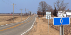
Indiana State Road 26
Encyclopedia
United States
The United States of America is a federal constitutional republic comprising fifty states and a federal district...
that crosses the entire state from east to west, covering a distance of about 150 miles (241.4 km).
Route description
State Road 26 begins on Indiana's western border with IllinoisIllinois
Illinois is the fifth-most populous state of the United States of America, and is often noted for being a microcosm of the entire country. With Chicago in the northeast, small industrial cities and great agricultural productivity in central and northern Illinois, and natural resources like coal,...
near the town of Ambia
Ambia, Indiana
Ambia is a town in Hickory Grove Township, Benton County, Indiana, United States. The population was 239 at the 2010 census. It is part of the Lafayette, Indiana Metropolitan Statistical Area.-History:...
. It ends on Indiana's eastern border near the town of Fort Recovery, Ohio
Fort Recovery, Ohio
Fort Recovery is a village in Mercer County, Ohio, United States. The population was 1,273 at the 2000 census. The village is near the location of Fort Recovery, first established in 1793 under orders from General Anthony Wayne....
. In Illinois, State Road 26 becomes Illinois Route 9
Illinois Route 9
Illinois Route 9 is a cross-state, east–west rural state highway in central Illinois. It runs from the Fort Madison Toll Bridge over the Mississippi River to Iowa in Niota east to State Road 26 at the Indiana border. This is a distance of ....
and in Ohio it turns into Ohio State Route 119
Ohio State Route 119
State Route 119 is an east–west highway serving rural sections of west-central Ohio. It begins just west of Fort Recovery at the eastern terminus of Indiana State Road 26 and intersects with State Route 49 in the virtual center of Fort Recovery. A "TO Indiana 26" shield can be seen...
.
With the exception of a stretch on the east side of Lafayette
Lafayette, Indiana
Lafayette is a city in and the county seat of Tippecanoe County, Indiana, United States, northwest of Indianapolis. As of the 2010 census, the city had a total population of 67,140. West Lafayette, on the other side of the Wabash River, is home to Purdue University, which has a large impact on...
, State Road 26 is an undivided surface road.
State Road 26 passes through the campus of Purdue University
Purdue University
Purdue University, located in West Lafayette, Indiana, U.S., is the flagship university of the six-campus Purdue University system. Purdue was founded on May 6, 1869, as a land-grant university when the Indiana General Assembly, taking advantage of the Morrill Act, accepted a donation of land and...
in West Lafayette
West Lafayette, Indiana
As of the census of 2010, there were 29,596 people, 12,591 households, and 3,588 families residing in the city. The population density was 5,381.1 people per square mile . The racial makeup of the city was 74.3% White, 17.3% Asian, 2.7% African American, 0.16% Native American, 0.03% Pacific...
, where it is concurrent with State Street.
It has an interchange with Interstate 65
Interstate 65
Interstate 65 is a major Interstate Highway in the United States. The southern terminus is located at an intersection with Interstate 10 in Mobile, Alabama, and its northern terminus is at an interchange with Interstate 90 , U.S. Route 12, and U.S...
east of Lafayette
Lafayette, Indiana
Lafayette is a city in and the county seat of Tippecanoe County, Indiana, United States, northwest of Indianapolis. As of the 2010 census, the city had a total population of 67,140. West Lafayette, on the other side of the Wabash River, is home to Purdue University, which has a large impact on...
and with Interstate 69
Interstate 69
Interstate 69 is an Interstate Highway in the United States. It exists in two parts: a completed highway from Indianapolis, Indiana, northeast to the Canadian border in Port Huron, Michigan, and a mostly proposed extension southwest to the Mexican border in Texas...
east of Fairmount
Fairmount, Indiana
Fairmount is a town in Fairmount Township, Grant County in the east central part of the U.S. state of Indiana. The population was 2,992 at the 2000 census. It is ninety kilometers northeast of Indianapolis...
.