
Igoumenitsa
Encyclopedia
Igoumenitsa is a coastal city in northwestern Greece
. It is the capital of the regional unit Thesprotia
. Its original ancient name used to be Titani.
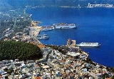
Igoumenitsa is a picturesque small town with lots of green (the dominating forest can be easily seen in the picture), beaches with crystal clear blue waters, and green mountains surrounding the town. The 670 km Egnatia Highway
, which serves northern Greece, terminates at Igoumenitsa.
during the 4th century BC, covering 28 hectares. The circumference of its walls was 2,400 metres. The walls had four gates. Internal walls, in the shape of a sickle, divided the city in half. Its most noteworthy tower, located at the top of the hill, was round, and is thought to have been a religious sanctuary. Excavations have revealed a theatre which seats 2,500 and ruins of two temples.
The city was a meeting place of the Epirote League (Livy 42.38.1). A spur near Philiates
between the Kalamas River
, the acropolis had a fine semicircular tower. A small theater, towers, and gateways which are still visible. The Kalamas may have been navigable to this point. The city was destroyed by the Romans
in 167 BC and later on it was annexed into the Roman Empire
. It was ruled by Ottoman Empire
and was renamed as "Reşadiye" in 1909 honour of Mehmet V, Ottoman Sultan between 1909 and 1918. During Italo-Turkish War
, Hamidiye torpedo boat was sunk by an Italian destroyer on December 30, 1912 in here.
After the liberation of the region from ottoman rule during the balkan wars in 1913, the city name was Grava (greek: Γράβα) which means "cave" in ancient greek and in 1938 became head of the prefecture of Thesprotia and renamed to Igoumenitsa.
During World War II
Igoumenitsa (Albanian
: Gumenica) was burned by Cham Albanian
collaborationist
bands.
, Greece to Brindisi
, Italy car–ferry ships of the Hellenic Mediterranean Lines (HML) stop at Igoumenitsa, before crossing the Adriatic Sea
and vice versa, as well as the ships of Superfast Ferries
, Anek Lines
and several other shipping companies, before going to Ancona
, Bari
or Venice
in Italy, and vice versa. Frequent passenger and car ferries to and from Corfu.
The Egnatia Odos
motorway, which was opened in 2009 and is part of the , has significantly enhanced the connection with Thessaloniki
and Turkey
and shortened the required travelling time from and to the Turkish border by several hours. Between Thessaloniki
and the Turkish border, the road runs more or less parallel to the ancient Roman
Via Egnatia
.
it is only 380 mm; in Crete
it is 640 mm, and in Ioannina
1,300 mm.
The temperature table are dated as of 2005.
The water is safe for swimming between the months of May to November, that's only half a year. In 2005, the town had 65 rainy days, the summer had 4 rainy days with 10 hours of mix of sun and clouds each day. The last 25 years, the lowest temperature was -9°C and the highest was 43°C.
Greece
Greece , officially the Hellenic Republic , and historically Hellas or the Republic of Greece in English, is a country in southeastern Europe....
. It is the capital of the regional unit Thesprotia
Thesprotia
Thesprotia is one of the regional units of Greece. It is part of the Epirus region. Its capital is the town of Igoumenitsa. It is named after the Thesprotians, an ancient Greek tribe that inhabited the region in antiquity.-History:...
. Its original ancient name used to be Titani.
Igoumenitsa is a picturesque small town with lots of green (the dominating forest can be easily seen in the picture), beaches with crystal clear blue waters, and green mountains surrounding the town. The 670 km Egnatia Highway
Egnatia Odos (modern road)
Egnatia Odos is the Greek part of the European route. It is a motorway in Greece that extends from the western port of Igoumenitsa to the eastern Greek–Turkish border at Kipoi. It runs a total of...
, which serves northern Greece, terminates at Igoumenitsa.
Municipality
The present municipality Igoumenitsa was formed at the 2011 local government reform by the merger of the following 5 former municipalities, that became municipal units (constituent communities in brackets):- Igoumenitsa (Agia Marina, Agios Vlasios, Graikochori, Igoumenitsa, KastriKastri, ThesprotiaKastri is a town in Thesprotia, Epirus, Greece. The local church is dedicated to Saint George.Until the end of World War II the town was inhabited mainly by an Orthodox Albanian-speaking community ....
, Kryovrysi, Ladochori, Mavroudi, Nea Selefkeia) - MargaritiMargaritiMargariti is a village and a former municipality in Thesprotia, Epirus, Greece. Since the 2011 local government reform it is part of the municipality Igoumenitsa, of which it is a municipal unit. Population 3,032 .-History:...
(Eleftheri, Karteri, Katavothra, Margariti, Mazarakia, Mesovouni, Spatharaioi) - ParapotamosParapotamosParapotamos is a village and a former municipality in Thesprotia, Epirus, Greece. Since the 2011 local government reform it is part of the municipality Igoumenitsa, of which it is a municipal unit. Population 1,668 . The village of Parapotamos, the former municipality's seat, was home to Cham...
(Drimitsa, Geroplatanos, Koritiani, Parapotamos) - PerdikaPerdikaPerdika is a village and a former community in Thesprotia, Epirus, Greece. Since the 2011 local government reform it is part of the municipality Igoumenitsa, of which it is a municipal unit. Population 2,272 ....
- SyvotaSyvotaSyvota , formerly Mourtos til 1953, is a village and a former municipality in Thesprotia, Epirus, Greece. Since the 2011 local government reform it is part of the municipality Igoumenitsa, of which it is a municipal unit. Population 3,010...
(Argyrotopos, Faskomilia, Plataria, Syvota)
History
In ancient times Igoumenitsa was known as Titani, (Gitani, Gitana, Goumani) and was one of the most important towns of the Kingdom of ThesprotisThesprotia
Thesprotia is one of the regional units of Greece. It is part of the Epirus region. Its capital is the town of Igoumenitsa. It is named after the Thesprotians, an ancient Greek tribe that inhabited the region in antiquity.-History:...
during the 4th century BC, covering 28 hectares. The circumference of its walls was 2,400 metres. The walls had four gates. Internal walls, in the shape of a sickle, divided the city in half. Its most noteworthy tower, located at the top of the hill, was round, and is thought to have been a religious sanctuary. Excavations have revealed a theatre which seats 2,500 and ruins of two temples.
The city was a meeting place of the Epirote League (Livy 42.38.1). A spur near Philiates
Thesprotia
Thesprotia is one of the regional units of Greece. It is part of the Epirus region. Its capital is the town of Igoumenitsa. It is named after the Thesprotians, an ancient Greek tribe that inhabited the region in antiquity.-History:...
between the Kalamas River
River Thyamis
The Thyamis , also known as Glycis or Kalamas, is a river in the Epirus region of Greece. It flows into the Ionian Sea. The names of the Chameria region , as well as the former Cham minority, derive from the river's name...
, the acropolis had a fine semicircular tower. A small theater, towers, and gateways which are still visible. The Kalamas may have been navigable to this point. The city was destroyed by the Romans
Roman Republic
The Roman Republic was the period of the ancient Roman civilization where the government operated as a republic. It began with the overthrow of the Roman monarchy, traditionally dated around 508 BC, and its replacement by a government headed by two consuls, elected annually by the citizens and...
in 167 BC and later on it was annexed into the Roman Empire
Roman Empire
The Roman Empire was the post-Republican period of the ancient Roman civilization, characterised by an autocratic form of government and large territorial holdings in Europe and around the Mediterranean....
. It was ruled by Ottoman Empire
Ottoman Empire
The Ottoman EmpireIt was usually referred to as the "Ottoman Empire", the "Turkish Empire", the "Ottoman Caliphate" or more commonly "Turkey" by its contemporaries...
and was renamed as "Reşadiye" in 1909 honour of Mehmet V, Ottoman Sultan between 1909 and 1918. During Italo-Turkish War
Italo-Turkish War
The Italo-Turkish or Turco-Italian War was fought between the Ottoman Empire and the Kingdom of Italy from September 29, 1911 to October 18, 1912.As a result of this conflict, Italy was awarded the Ottoman provinces of Tripolitania, Fezzan, and...
, Hamidiye torpedo boat was sunk by an Italian destroyer on December 30, 1912 in here.
After the liberation of the region from ottoman rule during the balkan wars in 1913, the city name was Grava (greek: Γράβα) which means "cave" in ancient greek and in 1938 became head of the prefecture of Thesprotia and renamed to Igoumenitsa.
During World War II
World War II
World War II, or the Second World War , was a global conflict lasting from 1939 to 1945, involving most of the world's nations—including all of the great powers—eventually forming two opposing military alliances: the Allies and the Axis...
Igoumenitsa (Albanian
Albanian language
Albanian is an Indo-European language spoken by approximately 7.6 million people, primarily in Albania and Kosovo but also in other areas of the Balkans in which there is an Albanian population, including western Macedonia, southern Montenegro, southern Serbia and northwestern Greece...
: Gumenica) was burned by Cham Albanian
Cham Albanians
Cham Albanians, or Chams , are a sub-group of Albanians who originally resided in the coastal region of Epirus in northwestern Greece, an area known among Albanians as Chameria. The Chams have their own peculiar cultural identity, which is a mixture of Albanian and Greek influences as well as many...
collaborationist
Axis-Cham Albanian collaboration
During the Axis occupation of Greece between 1941 and 1944, large parts of the Albanian minority in the Thesprotia prefecture in Epirus, northwestern Greece, known as Chams collaborated with the occupation forces. Fascist Italian as well as Nazi German propaganda promised that the region would be...
bands.
Traffic
The PatrasPatras
Patras , ) is Greece's third largest urban area and the regional capital of West Greece, located in northern Peloponnese, 215 kilometers west of Athens...
, Greece to Brindisi
Brindisi
Brindisi is a city in the Apulia region of Italy, the capital of the province of Brindisi, off the coast of the Adriatic Sea.Historically, the city has played an important role in commerce and culture, due to its position on the Italian Peninsula and its natural port on the Adriatic Sea. The city...
, Italy car–ferry ships of the Hellenic Mediterranean Lines (HML) stop at Igoumenitsa, before crossing the Adriatic Sea
Adriatic Sea
The Adriatic Sea is a body of water separating the Italian Peninsula from the Balkan peninsula, and the system of the Apennine Mountains from that of the Dinaric Alps and adjacent ranges...
and vice versa, as well as the ships of Superfast Ferries
Superfast Ferries
Superfast Ferries is a Greece-based ferry company founded in 1993 by Pericles Panagopulos and Alexander Panagopulos. Superfast Ferries is a member of Attica Group and operates 5 ultra-modern car-passenger ferries, offering daily connections between Ancona and Bari and Patras and Igoumenitsa...
, Anek Lines
ANEK Lines
ANEK Lines is a shipping company in Greece. It was founded in 1967 by numerous shareholders who were inhabitants of Crete. It operates passenger ferries, mainly on Piraeus-Crete and Adriatic Sea lines....
and several other shipping companies, before going to Ancona
Ancona
Ancona is a city and a seaport in the Marche region, in central Italy, with a population of 101,909 . Ancona is the capital of the province of Ancona and of the region....
, Bari
Bari
Bari is the capital city of the province of Bari and of the Apulia region, on the Adriatic Sea, in Italy. It is the second most important economic centre of mainland Southern Italy after Naples, and is well known as a port and university city, as well as the city of Saint Nicholas...
or Venice
Venice
Venice is a city in northern Italy which is renowned for the beauty of its setting, its architecture and its artworks. It is the capital of the Veneto region...
in Italy, and vice versa. Frequent passenger and car ferries to and from Corfu.
The Egnatia Odos
Egnatia Odos (modern road)
Egnatia Odos is the Greek part of the European route. It is a motorway in Greece that extends from the western port of Igoumenitsa to the eastern Greek–Turkish border at Kipoi. It runs a total of...
motorway, which was opened in 2009 and is part of the
Thessaloniki
Thessaloniki , historically also known as Thessalonica, Salonika or Salonica, is the second-largest city in Greece and the capital of the region of Central Macedonia as well as the capital of the Decentralized Administration of Macedonia and Thrace...
and Turkey
Turkey
Turkey , known officially as the Republic of Turkey , is a Eurasian country located in Western Asia and in East Thrace in Southeastern Europe...
and shortened the required travelling time from and to the Turkish border by several hours. Between Thessaloniki
Thessaloniki
Thessaloniki , historically also known as Thessalonica, Salonika or Salonica, is the second-largest city in Greece and the capital of the region of Central Macedonia as well as the capital of the Decentralized Administration of Macedonia and Thrace...
and the Turkish border, the road runs more or less parallel to the ancient Roman
Roman Republic
The Roman Republic was the period of the ancient Roman civilization where the government operated as a republic. It began with the overthrow of the Roman monarchy, traditionally dated around 508 BC, and its replacement by a government headed by two consuls, elected annually by the citizens and...
Via Egnatia
Via Egnatia
The Via Egnatia was a road constructed by the Romans in the 2nd century BC. It crossed the Roman provinces of Illyricum, Macedonia, and Thrace, running through territory that is now part of modern Albania, the Republic of Macedonia, Greece, and European Turkey.Starting at Dyrrachium on the...
.
Historical population
| Year | Town population | Municipality population |
|---|---|---|
| 1981 | 6,389 | - |
| 1991 | 6,807 | 11,608 |
| 2001 | 9,104 | 14,710 |
Climate
The average rainfall in Igoumenitsa is around 1,100 mm. By comparison in AthensAthens
Athens , is the capital and largest city of Greece. Athens dominates the Attica region and is one of the world's oldest cities, as its recorded history spans around 3,400 years. Classical Athens was a powerful city-state...
it is only 380 mm; in Crete
Crete
Crete is the largest and most populous of the Greek islands, the fifth largest island in the Mediterranean Sea, and one of the thirteen administrative regions of Greece. It forms a significant part of the economy and cultural heritage of Greece while retaining its own local cultural traits...
it is 640 mm, and in Ioannina
Ioannina
Ioannina , often called Jannena within Greece, is the largest city of Epirus, north-western Greece, with a population of 70,203 . It lies at an elevation of approximately 500 meters above sea level, on the western shore of lake Pamvotis . It is located within the Ioannina municipality, and is the...
1,300 mm.
The temperature table are dated as of 2005.
| Month | Inland temperature |
Sea temperature |
|---|---|---|
| January | 12°C | 16°C |
| February | 9°C | 15°C |
| March | 14°C | 16°C |
| April | 16°C | 17°C |
| May | 22°C | 19°C |
| June | 25°C | 22°C |
| July | 28°C | 24°C |
| August | 27°C | 25°C |
| September | 25°C | 24°C |
| October | 20°C | 23°C |
| November | 18°C | 20°C |
| December | 13°C | 17°C |
The water is safe for swimming between the months of May to November, that's only half a year. In 2005, the town had 65 rainy days, the summer had 4 rainy days with 10 hours of mix of sun and clouds each day. The last 25 years, the lowest temperature was -9°C and the highest was 43°C.