
Iceberg B-15
Encyclopedia
Iceberg
An iceberg is a large piece of ice from freshwater that has broken off from a snow-formed glacier or ice shelf and is floating in open water. It may subsequently become frozen into pack ice...
s. It measured around 295 km long and 37 km wide (183-23 mi), with a surface area of 11,000 km² (4,250 mi²) larger than the island of Jamaica
Jamaica
Jamaica is an island nation of the Greater Antilles, in length, up to in width and 10,990 square kilometres in area. It is situated in the Caribbean Sea, about south of Cuba, and west of Hispaniola, the island harbouring the nation-states Haiti and the Dominican Republic...
. The mass was estimated around three billion tonnes. After almost a decade, parts of B-15 still have not melted.
Background
CalvedIce calving
Ice calving, also known as glacier calving or iceberg calving, is a form of ice ablation or ice disruption. It is the sudden release and breaking away of a mass of ice from a glacier, iceberg, ice front, ice shelf, or crevasse...
from the Ross Ice Shelf
Ross Ice Shelf
The Ross Ice Shelf is the largest ice shelf of Antarctica . It is several hundred metres thick. The nearly vertical ice front to the open sea is more than 600 km long, and between 15 and 50 metres high above the water surface...
near Roosevelt Island
Roosevelt Island, Antarctica
Roosevelt Island is an ice-covered island, about long in a NW-SE direction, wide and about in area, lying in the eastern part of the Ross Ice Shelf of Antarctica...
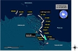
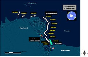
in March 2000, B-15 broke up into several pieces in 2000, 2002 and 2003, the largest of which, B-15A, covered 6,400 km² of the sea surface. In November 2003, after the separation from B-15J iceberg, B-15A drifted away from Ross Island
Ross Island
Ross Island is an island formed by four volcanoes in the Ross Sea near the continent of Antarctica, off the coast of Victoria Land in McMurdo Sound.-Geography:...
on the open waters of the Ross Sea.
In December 2003 a small knife-shaped iceberg, B-15K (about 300 km²), detached itself from the main body of B-15A and started drifting northward.
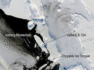
In 2005 prevailing currents took B-15A slowly past the Drygalski Ice Tongue; the collision broke off the tip of Drygalski in mid-April.
Then the iceberg sailed on along the coast leaving McMurdo Sound
McMurdo Sound
The ice-clogged waters of Antarctica's McMurdo Sound extend about 55 km long and wide. The sound opens into the Ross Sea to the north. The Royal Society Range rises from sea level to 13,205 feet on the western shoreline. The nearby McMurdo Ice Shelf scribes McMurdo Sound's southern boundary...
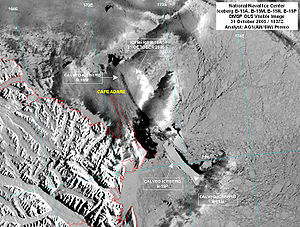
until it ran aground off Cape Adare
Cape Adare
Cape Adare is the northeastern most peninsula in Victoria Land, East Antarctica. The cape separates the Ross Sea to the east from the Southern Ocean to the west, and is backed by the high Admiralty Mountains...
in Victoria Land
Victoria Land
Victoria Land is a region of Antarctica bounded on the east by the Ross Ice Shelf and the Ross Sea and on the west by Oates Land and Wilkes Land. It was discovered by Captain James Clark Ross in January 1841 and named after the UK's Queen Victoria...
and broke into several smaller pieces on 27–28 October 2005. The largest piece was still named B-15A (now measuring approx. 1,700 km²), while three additional pieces were named B-15P, B-15M and B-15N.
It then moved farther up north and broke up into more pieces. These were spotted by air force fisheries patrol on 3 November 2006. On 21 November 2006 several large pieces were seen just 60 km off the coast of Timaru, New Zealand. The largest measured about 1.8 km (~1 mi), rising 37 m (120 ft) from the surface of the ocean.
Effect on Antarctic ecology
On April 10, 2005 B-15A hit the Drygalski ice tongue, a projection of the fast-moving David GlacierDavid Glacier
David Glacier is the most imposing outlet glacier in Victoria Land, Antarctica, fed by two main flows which drain an area larger than 200,000 square kilometres of the East Antarctic plateau, with an estimated ice discharge rate of 7.8 +/- 0.7 km³/year...
that flows through Antarctica's mountainous Victoria Land
Victoria Land
Victoria Land is a region of Antarctica bounded on the east by the Ross Ice Shelf and the Ross Sea and on the west by Oates Land and Wilkes Land. It was discovered by Captain James Clark Ross in January 1841 and named after the UK's Queen Victoria...
coastal region, breaking off an 8 km² (3 mi²) section of the ice tongue. This collision with the Drygalski tongue forced a redrawing of Antarctic maps.
B-15A prevented ocean currents and winds from assisting in the 2004–2005 summer break-up of the sea ice in McMurdo Sound
McMurdo Sound
The ice-clogged waters of Antarctica's McMurdo Sound extend about 55 km long and wide. The sound opens into the Ross Sea to the north. The Royal Society Range rises from sea level to 13,205 feet on the western shoreline. The nearby McMurdo Ice Shelf scribes McMurdo Sound's southern boundary...
, and was an obstacle to the annual resupply ships to three research stations. The floe was expected to cause a catastrophic decline in the population of Adelie Penguin
Adelie Penguin
The Adélie Penguin, Pygoscelis adeliae, is a species of penguin common along the entire Antarctic coast. They are among the most southerly distributed of all seabirds, as are the Emperor Penguin, the South Polar Skua, the Wilson's Storm Petrel, the Snow Petrel, and the Antarctic Petrel...
s, as it added considerable distances which parent penguins must travel back from the sea to their chicks. Weddell seal
Weddell Seal
The Weddell seal , is a relatively large and abundant true seal with a circumpolar distribution surrounding Antarctica. Weddell seals have the most southerly distribution of any mammal, with a habitat that extends as far south as McMurdo Sound...
s and Skuas are also inhabitants of McMurdo Sound and their populations may have been affected as well.
Global warming
Global warming refers to the rising average temperature of Earth's atmosphere and oceans and its projected continuation. In the last 100 years, Earth's average surface temperature increased by about with about two thirds of the increase occurring over just the last three decades...
. A more recent and detailed study by Martin et al. (2010), however, indicates that the iceberg breakup was principally caused by repeated grounding with near-coastal bathymetry
Bathymetry
Bathymetry is the study of underwater depth of lake or ocean floors. In other words, bathymetry is the underwater equivalent to hypsometry. The name comes from Greek βαθύς , "deep", and μέτρον , "measure"...
near Cape Adare
Cape Adare
Cape Adare is the northeastern most peninsula in Victoria Land, East Antarctica. The cape separates the Ross Sea to the east from the Southern Ocean to the west, and is backed by the high Admiralty Mountains...
, Victoria Land.
See also
- Iceberg B-9Iceberg B-9Iceberg B-9 154 km by 35 km calved away from Antarctica, from the sector east of Roosevelt Island, neighbouring the Bay of Whales and immediately east of the calving site of Iceberg B-15. It carried away Little America V....
- Iceberg B-17BIceberg B-17BIceberg B-17B is an iceberg twice the size of Manhattan, floating in the southern ocean approximately off the coast of Western Australia. Iceberg B-17B measures approximately and calved off the Ross Ice Shelf in 1999....
- Iceberg C-19Iceberg C-19Iceberg C-19 is an iceberg that calved from the Ross Ice Shelf on May 2002 on a fissure scientists had been watching since the 1980s. After that the Ross Ice Shelf returned to the size it was in 1911, when it was mapped by Robert F. Scott’s party. It was the second-largest iceberg to calve in the...
- Iceberg D-16Iceberg D-16Iceberg D-16 is a city-sized iceberg near Antarctica, discovered on March 26, 2006 by the National Ice Center using satellite imagery from the Defense Meteorological Satellite Program...
- McMurdo SoundMcMurdo SoundThe ice-clogged waters of Antarctica's McMurdo Sound extend about 55 km long and wide. The sound opens into the Ross Sea to the north. The Royal Society Range rises from sea level to 13,205 feet on the western shoreline. The nearby McMurdo Ice Shelf scribes McMurdo Sound's southern boundary...
External links
- ESA satellite monitoring, updated frequently
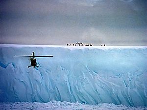
- Pictures from 3 research trips to the icebergs
- Satellite pictures of the iceberg's fragments from the Antarctic Meteorological Research Center
- Situation around Balleby Islands; Icebergs B-15A, B-15N, C-19A, ESAEuropean Space AgencyThe European Space Agency , established in 1975, is an intergovernmental organisation dedicated to the exploration of space, currently with 18 member states...
MERIS Level 1 Selected Image, 2 March 2006. - Envisat shows behemoth B-15A iceberg breaking up, ESAEuropean Space AgencyThe European Space Agency , established in 1975, is an intergovernmental organisation dedicated to the exploration of space, currently with 18 member states...
News, 7 November 2005. - Pile-up as berg hits Antarctica, BBC News OnlineBBC News OnlineBBC News Online is the website of BBC News, the division of the BBC responsible for newsgathering and production. The website is the most popular news website in the United Kingdom and forms a major part of BBC Online ....
, 19 April 2005. - Get Ready for the Largest Demolition Derby on the Planet, NASANASAThe National Aeronautics and Space Administration is the agency of the United States government that is responsible for the nation's civilian space program and for aeronautics and aerospace research...
, 6 January 2005. - The Iceberg Cometh, The GuardianThe GuardianThe Guardian, formerly known as The Manchester Guardian , is a British national daily newspaper in the Berliner format...
, 15 December 2004. - NASA Earth Observatory images, NovemberNovember 2004November 2004: January – February – March – April – May – June – July – August – September – October – November – December-Events:November 2004: January – February – March – April – May – June – July – August – September – October – November – December-Events:November 2004: January – February –...
- December 2004 - Video of the Iceberg Space monitoring